Reduced catlin (2 risultati)
Editore: [Longman, Rees, Orme, Brown, and Green] [1831], London 1831
Da: Attic Books (ABAC, ILAB), London, ON, CanadaAttic Books (ABAC, ILAB)
Contatta il venditoreVenditore con 5 stelleCondizione: Usato - Quasi ottimo
EUR 179,51
EUR 13,07 spedizioneSpedito da Canada a U.S.A.Quantità: 1 disponibili
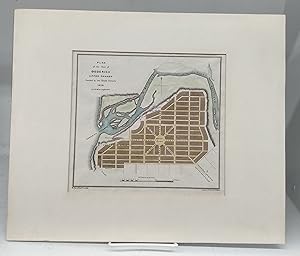
Condizione: Near fine. 22 x 28 cm page with 19 x 20 cm coloured steel engraving map. Taped to 32 x 38 cm cardboard frame. Source is "The British Dominions in North America; or a Topographical and Statistical Description of the Provinces of Lower and Upper Canada, New Brunswick, Nova Scotia, the Island of Newfoundland, Prince Edw…ard, and Cape Breton," published 1831. J & C Walker - John Walker, Alexander Walker and Charles Walker, known collectively as J & C Walker (active 1820-95) - were engravers, draughtsmen and publishers working through the 19th century. The firm engraved a large corpus of work for the British Admiralty and produced numerous high-quality geographical maps and nautical charts for a variety of other institutions. This map of Goderich, Huron County shows early street names, Maitland River, marketplace, etc.
Editore: [Longman, Rees, Orme, Brown, and Green] [1831], London 1831
Da: Attic Books (ABAC, ILAB), London, ON, CanadaAttic Books (ABAC, ILAB)
Contatta il venditoreVenditore con 5 stelleCondizione: Usato - Quasi ottimo
EUR 179,51
EUR 13,07 spedizioneSpedito da Canada a U.S.A.Quantità: 1 disponibili
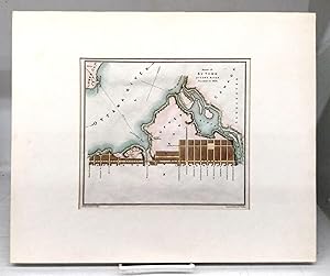
Condizione: Near fine. 21 x 27 cm page with 18 x 20 cm coloured steel engraving map. Taped to 32 x 39 cm cardboard frame. Source is "The British Dominions in North America; or a Topographical and Statistical Description of the Provinces of Lower and Upper Canada, New Brunswick, Nova Scotia, the Island of Newfoundland, Prince Edw…ard, and Cape Breton," published 1831. J & C Walker - John Walker, Alexander Walker and Charles Walker, known collectively as J & C Walker (active 1820-95) - were engravers, draughtsmen and publishers working through the 19th century. The firm engraved a large corpus of work for the British Admiralty and produced numerous high-quality geographical maps and nautical charts for a variety of other institutions. This map of Bytown (now Ottawa) shows early street names.

