Importo totale (1 articolo articoli):
Destinazione ordine:

sanborn map company (35 risultati)
Vai alla pagina principale dei risultati di ricerca
Filtri di ricerca
Tipo di articolo
- Tutti i tipi di prodotto
- Libri (33)
- Riviste e Giornali (Nessun altro risultato corrispondente a questo perfezionamento)
- Fumetti (Nessun altro risultato corrispondente a questo perfezionamento)
- Spartiti (Nessun altro risultato corrispondente a questo perfezionamento)
- Arte, Stampe e Poster (Nessun altro risultato corrispondente a questo perfezionamento)
- Fotografie (Nessun altro risultato corrispondente a questo perfezionamento)
- Mappe (2)
- Manoscritti e Collezionismo cartaceo (Nessun altro risultato corrispondente a questo perfezionamento)
Condizioni Maggiori informazioni
- Nuovo (8)
- Come nuovo, Ottimo o Quasi ottimo (Nessun altro risultato corrispondente a questo perfezionamento)
- Molto buono o Buono (19)
- Discreto o Mediocre (2)
- Come descritto (6)
Legatura
Ulteriori caratteristiche
- Prima ed. (1)
- Copia autograf. (Nessun altro risultato corrispondente a questo perfezionamento)
- Sovracoperta (Nessun altro risultato corrispondente a questo perfezionamento)
- Con foto (32)
- Non Print on Demand (27)
Lingua (2)
Spedizione gratuita
Paese del venditore
Valutazione venditore
-
1931 Waterville Maine Plat Map Kennebeck County
Lingua: Inglese
Editore: Sanborn Map Company, 1931
Da: Lavendier Books, Foster, RI, U.S.A.
Valutazione del venditore 5 su 5 stelle

Hardcover. Condizione: Fair. Sanborn Map Company; New York, 1931. Boards. Large Plat Map of Waterville Maine (Kennebeck County). An Acceptable, tan boards and tan cloth spine, paper title label affirmed to front board but partially missing, publisher info in black lettering on bottom board, the book is well worn with several handling marks and notations, heavy handling/scuffing to boards, ink stamp on front board, few soiled spots on boards, exposed board corners with heavy wear, age toning to pages, board corners are soft, few dog-eared pages and some creasing to pages, 12-page Description and Utilization of the Sanborn Map pamphlet laid in, another fold-out map also laid in, waving to pages along edges (possible moisture damage) though no moisture stains to text block, binding is intact but shaky due to size of book. A working copy. 4to[quarto or approx. 13.5 x 21.5 inches], We pack securely and ship daily with delivery confirmation on every book. The picture on the listing page is of the actual book for sale. Additional Scan(s) are available for any item, please inquire.Please note: Oversized books/sets MAY require additional postage then what is quoted for 2.2lb book.
-

Insurance Maps of Kingston New York
Lingua: Inglese
Editore: Sanborn Map Company, 1957
Da: Shaker Mill Books, W. Stockbridge, MA, U.S.A.
Valutazione del venditore 5 su 5 stelle
Hardcover. Condizione: Very Good. Bar-Loc (Style "B") 13 x 14 x 3" Notebook containing 51 transparent envelopes in which map sheets are encased (pages numbered 1-91). Tan boards, burgundy labels to front and to spine strip with bright gilt lettering, all maps are colorful and unmarked. Will require additional shipping charge. Laid in: 2 description and utilization booklets plastic square foot template in envelope folded highway map of Ulster County 2 folded maps showing residence, business & industrial zones folded map of the City of Kingston.
-
![Immagine del venditore per Sanborn services for city and regional planners. 1969 [LeatherBound] venduto da S N Books World](https://pictures.abebooks.com/inventory/md/md31650029412.jpg)
Sanborn services for city and regional planners. 1969 [LeatherBound]
Lingua: Inglese
Data di pubblicazione: 2025
EUR 21,47
Spedizione gratuita
Spedito da India a U.S.A.Quantit�: 18 disponibili
Aggiungi al carrelloLeatherBound. Condizione: New. BOOKS ARE EXEMPT FROM IMPORT DUTIES AND TARIFFS; NO EXTRA CHARGES APPLY. Leatherbound edition. Condition: New. Leather Binding on Spine and Corners with Golden leaf printing on spine. Bound in genuine leather with Satin ribbon page markers and Spine with raised gilt bands. Pages: 32. A perfect gift for your loved ones. Reprinted from 1969 edition. NO changes have been made to the original text. This is NOT a retyped or an ocr'd reprint. Illustrations, Index, if any, are included in black and white. Each page is checked manually before printing. As this print on demand book is reprinted from a very old book, there could be some missing or flawed pages, but we always try to make the book as complete as possible. Fold-outs, if any, are not part of the book. If the original book was published in multiple volumes then this reprint is of only one volume, not the whole set. IF YOU WISH TO ORDER PARTICULAR VOLUME OR ALL THE VOLUMES YOU CAN CONTACT US. Resized as per current standards. Sewing binding for longer life, where the book block is actually sewn (smythe sewn/section sewn) with thread before binding which results in a more durable type of binding. Language: English Pages: 32.
-
![Immagine del venditore per Description and utilization of the Sanborn map. 1940 [LeatherBound] venduto da S N Books World](https://pictures.abebooks.com/inventory/md/md30877558953.jpg)
Description and utilization of the Sanborn map. 1940 [LeatherBound]
Lingua: Inglese
Data di pubblicazione: 2025
EUR 21,47
Spedizione gratuita
Spedito da India a U.S.A.Quantit�: 18 disponibili
Aggiungi al carrelloLeatherBound. Condizione: NEW. BOOKS ARE EXEMPT FROM IMPORT DUTIES AND TARIFFS; NO EXTRA CHARGES APPLY. Leather Binding on Spine and Corners with Golden leaf printing on spine. Bound in genuine leather with Satin ribbon page markers and Spine with raised gilt bands. A perfect gift for your loved ones. Reprinted from 1940 edition. NO changes have been made to the original text. This is NOT a retyped or an ocr'd reprint. Illustrations, Index, if any, are included in black and white. Each page is checked manually before printing. As this print on demand book is reprinted from a very old book, there could be some missing or flawed pages, but we always try to make the book as complete as possible. Fold-outs, if any, are not part of the book. If the original book was published in multiple volumes then this reprint is of only one volume, not the whole set and contains approximately 20 pages. IF YOU WISH TO ORDER PARTICULAR VOLUME OR ALL THE VOLUMES YOU CAN CONTACT US. Resized as per current standards. Sewing binding for longer life, where the book block is actually sewn (smythe sewn/section sewn) with thread before binding which results in a more durable type of binding. Language: English.
-
![Immagine del venditore per Description and utilization of the Sanborn map 1949 [LeatherBound] venduto da S N Books World](https://pictures.abebooks.com/inventory/md/md30863571538.jpg)
Description and utilization of the Sanborn map 1949 [LeatherBound]
Lingua: Inglese
Data di pubblicazione: 2025
EUR 21,47
Spedizione gratuita
Spedito da India a U.S.A.Quantit�: 18 disponibili
Aggiungi al carrelloLeatherbound. Condizione: NEW. BOOKS ARE EXEMPT FROM IMPORT DUTIES AND TARIFFS; NO EXTRA CHARGES APPLY. Leather Binding on Spine and Corners with Golden leaf printing on spine. Bound in genuine leather with Satin ribbon page markers and Spine with raised gilt bands. A perfect gift for your loved ones. Reprinted from 1949 edition. NO changes have been made to the original text. This is NOT a retyped or an ocr'd reprint. Illustrations, Index, if any, are included in black and white. Each page is checked manually before printing. As this print on demand book is reprinted from a very old book, there could be some missing or flawed pages, but we always try to make the book as complete as possible. Fold-outs, if any, are not part of the book. If the original book was published in multiple volumes then this reprint is of only one volume, not the whole set and contains approximately 34 pages. IF YOU WISH TO ORDER PARTICULAR VOLUME OR ALL THE VOLUMES YOU CAN CONTACT US. Resized as per current standards. Sewing binding for longer life, where the book block is actually sewn (smythe sewn/section sewn) with thread before binding which results in a more durable type of binding. Language: English.
-
![Immagine del venditore per Pittsburgh Area Transportation Study land use survey manual 1960 1960 [LeatherBound] venduto da S N Books World](https://pictures.abebooks.com/inventory/md/md30863727214.jpg)
Pittsburgh Area Transportation Study land use survey manual 1960 1960 [LeatherBound]
Lingua: Inglese
Data di pubblicazione: 2025
EUR 26,84
Spedizione gratuita
Spedito da India a U.S.A.Quantit�: 18 disponibili
Aggiungi al carrelloLeatherbound. Condizione: NEW. BOOKS ARE EXEMPT FROM IMPORT DUTIES AND TARIFFS; NO EXTRA CHARGES APPLY. Leatherbound edition. Condition: New. Leather Binding on Spine and Corners with Golden leaf printing on spine. Bound in genuine leather with Satin ribbon page markers and Spine with raised gilt bands. Pages: 102. A perfect gift for your loved ones. Reprinted from 1960 edition. NO changes have been made to the original text. This is NOT a retyped or an ocr'd reprint. Illustrations, Index, if any, are included in black and white. Each page is checked manually before printing. As this print on demand book is reprinted from a very old book, there could be some missing or flawed pages, but we always try to make the book as complete as possible. Fold-outs, if any, are not part of the book. If the original book was published in multiple volumes then this reprint is of only one volume, not the whole set. IF YOU WISH TO ORDER PARTICULAR VOLUME OR ALL THE VOLUMES YOU CAN CONTACT US. Resized as per current standards. Sewing binding for longer life, where the book block is actually sewn (smythe sewn/section sewn) with thread before binding which results in a more durable type of binding. Language: English Pages: 102.
-
Torrington, Connecticut (Fire Insurance Map)
Editore: Sanborn Map Company, New York, 1931
Da: Carydale Books, Rhinebeck, NY, U.S.A.
Valutazione del venditore 5 su 5 stelle
Hardcover. Condizione: Good. Early Edition. This is 40 folio sheets, folded, of details of Torrington, CT in 1931 with the various buildings colored The maps measure ca. 21 x 25" and the 40 sheets cover the entire city at the time. The Library of Congress shows the earliest set of such maps were done in 1886 with updated versions published every so many years. They were often heavily used and often destroyed once considered too old for their intended use, thus copies are uncommon. This set has printed notes inside suggesting 1951 updates were made and there are many hand- done alterations to indicate buildings removed or added. Thus, they are quite interesting for historical study.The maps are bound in a heavily worn book with labels indicating it was from a Boston Insurance library, The maps are generally in good or better condition, some have many mark, others have few. Overall a good copy. (3651) Note: due to size and weight, shipping out side the USA or priorty shipping will cost more than an average book.
-
Sanborn Map Company. Fayette, Fayette County, Alabama November 1928. [Bound collection of Sanborn fire-property insurance maps for Fayette, Alabama.]
Editore: New York: Sanborn Map Company (11 Broadway, New York City), November 1928., 1928
Da: David Hallinan, Bookseller, Columbus, MS, U.S.A.
Valutazione del venditore 5 su 5 stelle
14 leaves (i.e. 28 pages) plus covers featuring seven hand-colored maps (numbered as 1-7) on rectos and opposing versos. Paperback folio: approximately H 21 5/16 inches x L 13 3/8 inches (H 54.3cm x L 34.2cm). Brown paper covers with some staining, soiling, and prevalent creasing as well as nicks and tears at edges; old tape rear to 4.5 inch horizontal tear at rear cover's center left extending inward from fore-edge; Sanborn imprint printed in black near bottom of front cover; original black cloth binding tape applied lengthwise along spine with slight fraying at ends. A few small stains and light soiling as well as a few pencil markings and annotations but, in overall general appearance, maps remain clean. Maps all specify "Copyright 1928" but several have printed initials/dates - Map #2 "G.H. | 1.29"; Map #4 "F.L. | 12.28"; Map #5 "F.P | 1.29"; Map #6 "G.H. | 1.29" - which are presumably the on-site cartographer's initials and month/year date notations. Index with Map #1 indicates that the folio has all seven maps that were prepared for the small city which, circa 1928, had approximately 2000 residents. {{Laid-in at folio's rear is an historically significant hand-drawn four-color downtown map tilted at top left "Fayette, Ala | 1912" uncredited but reflecting Sanborn detail recording structures, lots, building uses, etc. primarily on blocks 1-7, 11-12, and 16-19; approx. H 22 inches x L 24 inches; multiple folds/creases, soiling and toning, several tears one of which has an old short tape repair, small losses at corners; paper quality and specificity of notes certainly seem to make this map contemporary to the 1912 date and not a later re-creation.}} Located in lower northwest Alabama, Fayette is the county seat of Fayette County and lies north of Tuscaloosa County and west-northwest of Birmingham. Fayette's diminutve urbaness makes it unlikely that Sanborn would have prepared a large print run - certainly fewer than fifty and quite likely perhaps even half that number. Please note that although the folio has a shipping weight of under 1.5 pounds (.68 kg) its oversized dimensions will likely require additional postage and insurance above AbeBooks' preset rate for any postal class other than domestic Media Mail.
-
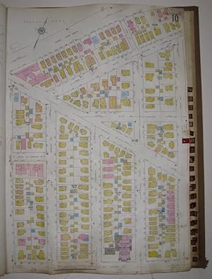
Vol. 7 of 29 Atlases of Insurance Maps for Queens. Hollis & Jamaica Estates
Editore: Sanborn Map Company, New York, 1925
Da: Argosy Book Store, ABAA, ILAB, New York, NY, U.S.A.
Membro dell'associazione: ABAA ILAB
Valutazione del venditore 5 su 5 stelle
hardcover. Condizione: very good(-). Atlas. Lithograph with original hand coloring. Massive elephant folio. Decorative calligraphic titles, indices, and key maps. Contains a set of 90 maps along with changes recorded on paste-on correction slips through 1974. Quarter leather binding with gilt title on front and spine. This volume includes part of South Jamaica, the Long Island Railroad split of the Main Line and the Montauk Line, and a Queens neighborhood reference inset. The Sanborn map collection consists of a uniform series of large scale maps, dating from 1867 to the present depicting the commercial, industrial, and residential sections of some twelve thousand cities and towns in the United States, Canada, and Mexico. The maps were designed to assist fire insurance agents in determining the degree of hazard associated with a particular property and therefore show the size, shape and construction of dwellings, commercial buildings, and factories as well as fire walls locations of windows and doors, sprinkler systems, and types of roofs. The maps also indicate widths and names of streets, property boundaries, building use, and house and block numbers. They show locations of water mains, giving their dimensions, and of fire alarm boxes and hydrants. Sanborn maps are an unrivaled source of information about the structure and use of buildings in American Cities. The collection includes some fifty thousand editions of fire insurance maps comprising an estimated seven hundred thousand individual sheets. The Library of Congress holdings represent the largest extant collection of maps produced by the Sanborn Map Company. The majority of the maps were acquired by the Library through copyright deposit, but the collection was substantially enriched in 1967 when the Bureau of the Census transferred to the Library of Congress a complete set. The 1,899 loose-leaf binders were particularly noteworthy because they included later editions than those previously acquired by the Library. The Bureau of the Census set of maps had been regularly updated by printed, paste-on corrections supplied by the Sanborn Map Company, whereas the Library of Congress copies were retained in the form in which they were copyrighted.
-
Vol. 8 of 29 Atlases of Insurance Maps for Brooklyn. East New York
Editore: Sanborn Map Company, New York, 1928
Da: Argosy Book Store, ABAA, ILAB, New York, NY, U.S.A.
Membro dell'associazione: ABAA ILAB
Valutazione del venditore 5 su 5 stelle
hardcover. Condizione: very good. Atlas. Lithograph with original hand coloring. Massive elephant folio. Decorative calligraphic titles, indices, and key maps. Contains a set of 76 detailed maps of East New York along with changes recorded on paste-on correction slips through 1973. Quarter leather binding with gilt title on front and spine. Original protective canvas cover in very good condition. This volume includes an inset "Map of Islands of Jamaica Bay, Brooklyn, NY", Sunrise Highway and Conduit Avenue Extension. The Sanborn map collection consists of a uniform series of large scale maps, dating from 1867 to the present depicting the commercial, industrial, and residential sections of some twelve thousand cities and towns in the United States, Canada, and Mexico. The maps were designed to assist fire insurance agents in determining the degree of hazard associated with a particular property and therefore show the size, shape and construction of dwellings, commercial buildings, and factories as well as fire walls locations of windows and doors, sprinkler systems, and types of roofs. The maps also indicate widths and names of streets, property boundaries, building use, and house and block numbers. They show locations of water mains, giving their dimensions, and of fire alarm boxes and hydrants. Sanborn maps are an unrivaled source of information about the structure and use of buildings in American Cities. The collection includes some fifty thousand editions of fire insurance maps comprising an estimated seven hundred thousand individual sheets. The Library of Congress holdings represent the largest extant collection of maps produced by the Sanborn Map Company. The majority of the maps were acquired by the Library through copyright deposit, but the collection was substantially enriched in 1967 when the Bureau of the Census transferred to the Library of Congress a complete set. The 1,899 loose-leaf binders were particularly noteworthy because they included later editions than those previously acquired by the Library. The Bureau of the Census set of maps had been regularly updated by printed, paste-on corrections supplied by the Sanborn Map Company, whereas the Library of Congress copies were retained in the form in which they were copyrighted.
-
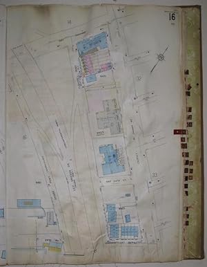
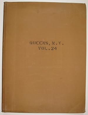
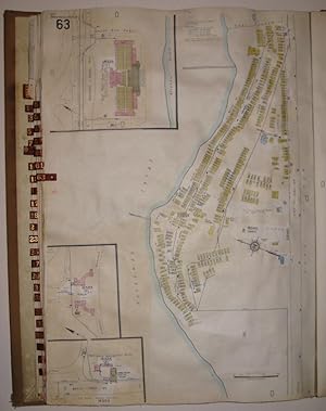
Vol. 24 of 29 Atlases of Insurance Maps for Queens. Flushing Heights & Jamaica
Editore: Sanborn Map Company, New York, 1934
Da: Argosy Book Store, ABAA, ILAB, New York, NY, U.S.A.
Membro dell'associazione: ABAA ILAB
Valutazione del venditore 5 su 5 stelle
hardcover. Condizione: very good. Atlas. Lithograph with original hand coloring. Massive elephant folio. Decorative calligraphic titles, indices, and key maps. Contains a set of 46 maps along with changes recorded on paste-on correction slips through 1974. Quarter leather binding with gilt title on front and spine. Original protective canvas cover in good condition. This volume includes Hillcrest and part of Jamaica Estates, Grand Central Parkway to the south and Horace Harding Expressway (Long Island Expressway) to the north. Also shown is Cedar Grove Cemetery (Mt. Hebron Cemetery) and a Queens neighborhood reference inset. St. John's University is included as well as Queens College CUNY campus. The Sanborn map collection consists of a uniform series of large scale maps, dating from 1867 to the present depicting the commercial, industrial, and residential sections of some twelve thousand cities and towns in the United States, Canada, and Mexico. The maps were designed to assist fire insurance agents in determining the degree of hazard associated with a particular property and therefore show the size, shape and construction of dwellings, commercial buildings, and factories as well as fire walls locations of windows and doors, sprinkler systems, and types of roofs. The maps also indicate widths and names of streets, property boundaries, building use, and house and block numbers. They show locations of water mains, giving their dimensions, and of fire alarm boxes and hydrants. Sanborn maps are an unrivaled source of information about the structure and use of buildings in American Cities. The collection includes some fifty thousand editions of fire insurance maps comprising an estimated seven hundred thousand individual sheets. The Library of Congress holdings represent the largest extant collection of maps produced by the Sanborn Map Company. The majority of the maps were acquired by the Library through copyright deposit, but the collection was substantially enriched in 1967 when the Bureau of the Census transferred to the Library of Congress a complete set. The 1,899 loose-leaf binders were particularly noteworthy because they included later editions than those previously acquired by the Library. The Bureau of the Census set of maps had been regularly updated by printed, paste-on corrections supplied by the Sanborn Map Company, whereas the Library of Congress copies were retained in the form in which they were copyrighted.
-
Vol. 18 of 29 Atlases of Insurance Maps for Queens.Howard Beach and Ozone Park
Editore: Sanborn Map Company, New York, 1927
Da: Argosy Book Store, ABAA, ILAB, New York, NY, U.S.A.
Membro dell'associazione: ABAA ILAB
Valutazione del venditore 5 su 5 stelle
hardcover. Condizione: very good. Atlas. Lithograph with original hand coloring. Massive elephant folio. Decorative calligraphic titles, indices, and key maps. Contains a set of 74 maps along with changes recorded on paste-on correction slips through 1973. Quarter leather binding with gilt title on front and spine. This volume includes Shore Parkway (Belt Parkway) and Conduit Avenue intersection and the Aqueduct Racetrack. Maps also show the original Spring Creek Basin reaching inland as far as Conduit Avenue, and the original shoreline along Jamaica Bay. The Sanborn map collection consists of a uniform series of large scale maps, dating from 1867 to the present depicting the commercial, industrial, and residential sections of some twelve thousand cities and towns in the United States, Canada, and Mexico. The maps were designed to assist fire insurance agents in determining the degree of hazard associated with a particular property and therefore show the size, shape and construction of dwellings, commercial buildings, and factories as well as fire walls locations of windows and doors, sprinkler systems, and types of roofs. The maps also indicate widths and names of streets, property boundaries, building use, and house and block numbers. They show locations of water mains, giving their dimensions, and of fire alarm boxes and hydrants. Sanborn maps are an unrivaled source of information about the structure and use of buildings in American Cities. The collection includes some fifty thousand editions of fire insurance maps comprising an estimated seven hundred thousand individual sheets. The Library of Congress holdings represent the largest extant collection of maps produced by the Sanborn Map Company. The majority of the maps were acquired by the Library through copyright deposit, but the collection was substantially enriched in 1967 when the Bureau of the Census transferred to the Library of Congress a complete set. The 1,899 loose-leaf binders were particularly noteworthy because they included later editions than those previously acquired by the Library. The Bureau of the Census set of maps had been regularly updated by printed, paste-on corrections supplied by the Sanborn Map Company, whereas the Library of Congress copies were retained in the form in which they were copyrighted.
-
Vol. 21 of 29 Atlases of Insurance Maps for Queens. Rockaway Peninsula & Broad Channel
Editore: Sanborn Map Company, New York, 1933
Da: Argosy Book Store, ABAA, ILAB, New York, NY, U.S.A.
Membro dell'associazione: ABAA ILAB
Valutazione del venditore 5 su 5 stelle
hardcover. Condizione: very good. Atlas. Lithograph with original hand coloring. Massive elephant folio. Decorative calligraphic titles, indices, and key maps. Contains a set of 73 maps along with changes recorded on paste-on correction slips through 1973. Quarter leather binding with gilt title on front and spine. Slight wear to original protective canvas cover. This volume includes Breezy Point, Belle Harbor, Arverne, Fort Tilden and Jacob Riis Park. Also included is a "Graphic Map of Volumes" of the Borough of Queens. The Sanborn map collection consists of a uniform series of large scale maps, dating from 1867 to the present depicting the commercial, industrial, and residential sections of some twelve thousand cities and towns in the United States, Canada, and Mexico. The maps were designed to assist fire insurance agents in determining the degree of hazard associated with a particular property and therefore show the size, shape and construction of dwellings, commercial buildings, and factories as well as fire walls locations of windows and doors, sprinkler systems, and types of roofs. The maps also indicate widths and names of streets, property boundaries, building use, and house and block numbers. They show locations of water mains, giving their dimensions, and of fire alarm boxes and hydrants. Sanborn maps are an unrivaled source of information about the structure and use of buildings in American Cities. The collection includes some fifty thousand editions of fire insurance maps comprising an estimated seven hundred thousand individual sheets. The Library of Congress holdings represent the largest extant collection of maps produced by the Sanborn Map Company. The majority of the maps were acquired by the Library through copyright deposit, but the collection was substantially enriched in 1967 when the Bureau of the Census transferred to the Library of Congress a complete set. The 1,899 loose-leaf binders were particularly noteworthy because they included later editions than those previously acquired by the Library. The Bureau of the Census set of maps had been regularly updated by printed, paste-on corrections supplied by the Sanborn Map Company, whereas the Library of Congress copies were retained in the form in which they were copyrighted.
-
[ Redondo Beach Fire Insurance Atlas] Redondo Beach Los Angeles Co. Cal.
Editore: Sanborn Map Company, 1916
Da: Barry Lawrence Ruderman, La Jolla, CA, U.S.A.
Membro dell'associazione: ABAA ILAB
Valutazione del venditore 5 su 5 stelle
Mappa
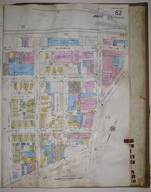
No Binding. Condizione: See Description. Sanborn Map Company / 1916 (updated to Sept. 1929) / [ Redondo Beach Fire Insurance Atlas] Redondo Beach Los Angeles Co. Cal. (Safe 4, 97315) Original hand-color. Unbound, with sheets mounted on alternating tabs. 19 maps, including the index page. Complete. Pastedown updates to September 1929. Old repaired horizontal tear to the index sheet (paper tape on verso). Some moderate crinkling and dust soiling to the map sheets. Else quite clean. Ink stamp of the Liverpool & London Globe Ins. Co., Ltd. Redondo Beach in 1929 Redondo Beach Los Angeles Co. Cal., produced by the Sanborn Map Company in 1916 and extensively updated in September 1929, provides a detailed mapping of Redondo Beach during the early 20th century - particularly as a document of the massively changing urban landscape between 1916 and 1929. This fire insurance atlas, comprising 19 sheets, was originally made as a specialized tool for insurance company underwriters in determining the degree of fire risk associated with any property shown therein. It offers rich visual insight into the built environment of the city, making it an invaluable resource for understanding the area's urban evolution at a time when automobile-focused infrastructure systems began to dominate the Southland. In the 1920s, Redondo Beach emerged as a quintessential seaside destination along the Pacific coast. Located southwest of Los Angeles, it transformed from its earlier reputation as a bustling port to a recreational haven. The decade saw the construction of the opulent Hotel Redondo, which became a magnet for tourists and Hollywood elite seeking sun, surf, and relaxation. The city's iconic pier, already an attraction since the late 1800s, was frequented by anglers, tourists, and locals alike. As the Jazz Age unfolded, Redondo Beach's sandy shores, dance pavilions, and oceanfront attractions encapsulated the era's penchant for leisure and pleasure, mirroring the Roaring Twenties' broader cultural zeitgeist. The atlas encompasses a breadth of information, ranging from the prevailing western winds to the intricacies of the city's water supply system maintained by the California Water Service Company. The gravity system for water distribution is documented alongside the complex framework of the fire department. This department was composed of both volunteer and full-time personnel. The atlas also provides insights into building classifications, indicating materials used in construction and their fire-resistance capabilities. The color-coding system categorizes structures based on their construction material, aiding in the identification of fire risks. Such detailed annotations underline the importance of safety standards during that era. A selection of the structures depicted include the following: Associated Oil Company Beryl Heights Public School Central Public School South Public School The Casino Hotel Redondo Hotel Clifton Sea Gull Inn Cafe Montgomery & Mullin Lumber Co. Redondo Beach Bath House Redondo Motor Car Company Southern California Edison Co. facilities Vincent Park (the area along El Redondo and nearby streets particularly rich with pasted updates of dozens of new dwellings) In sum, Redondo Beach Los Angeles Co. Cal. is an unparalleled record of Redondo Beach's infrastructure and urban layout during the early 20th century. It offers a clear picture of the growth processes in the 1920s, urban development, and safety standards that shaped the community during that time. Rarity The Redondo Beach Sanborn atlas is very rare in the market. The only other example of the September 1929 update we can trace is held at California State Northridge. Not a single example of any Redondo. Map.
-
Insurance Maps of Long Beach California [volumes 1-3, including Signal Hill and part of Lakewood]
Editore: Sanborn Map Company, 1914
Da: Barry Lawrence Ruderman, La Jolla, CA, U.S.A.
Membro dell'associazione: ABAA ILAB
Valutazione del venditore 5 su 5 stelle
Hardcover. Condizione: Good. Sanborn Map Company / 1914 - 1957 / [Los Angeles Fire Insurance Atlas] Insurance Maps of Long Beach California [volumes 1-3, including Signal Hill and part of Lakewood] (Safe 4, 98218) Large folio. 3 volumes. Approximately 241 map sheets. Original thick tan cloth bindings, leather corners, red leather labels to front covers, with remnants of leather spine labels (mostly chipped away except on vol. 2). Most of the leather thumb tabs still intact. Bindings worn, with some staining. Vol. 1 with occasional staining and some insect damage (to lower margin of several map sheets toward back of volume). Vol. 3 with significant foxing and soiling. Else overall condition of the maps is quite good. Ownership stamp: Aetna Insurance Co. Vol 1: Title page, index, key map, 1-99, 99A maps [sheet 29 blank, 30-31 skipped, 41 blank, 42-45 skipped, 53 blank, 54-59 skipped, but likely not issued as the blank and skipped numbers are not on key map]. Vol. 2: Title page, index, double-sheet key map, 201-299, 299A-299E. Vol. 3: double-sheet key map plus 301-362 maps [sheet 323 blank, nos. 332-337 and 346-351 skipped in numbering, but these maps likely not issued as they do not appear on key map]. The Most Detailed Mapping of Long Beach's Built Environment Over the First Half of the 20th-Century The present massive 3-volume Long Beach Sanborn fire insurance atlas, containing approximately 241 map sheets, is remarkable for documenting immense changes to the city's built landscape over nearly half a century (1914-1957). The respective pasted-in updates having been dutifully inserted by Sanborn Map employees over the course of 38 dated visits, as indicated in the update log of each volume. Various index updates are also included in the opening pages of each volume. This 3-volume atlas includes information on Long Beach's urban layout, water facilities, factories, Signal Hill oil district, industrial buildings, providing a detailed representation of the city's infrastructure systems during the first half of the 20th century. Executed with a scale 50 feet to an inch, the atlas shows nearly every building in Long Beach, with block-by-block, street-by-street, structure-by-structure, color-coded representations. Use of each structure is given: dwelling, grocery, storage, lumber yard, movie theater, church, hardware, etc., often recording the name of the individual business owner. Color coding denotes building material (yellow for frame structures, tan/brown for fireproof buildings; red for brick, blue for stone, and the like). The first volume includes a special WWII-era notice printed in red ink citing the U.S. Espionage Act, referring to the need to keep information concerning properties related to National Defense activities strictly confidential. Further stating: Tracings or other reproductions of Sanborn Maps in full or in part are prohibited. The Growth of Long Beach After a faltering start in the 1880s as an agricultural colony (originally named for its founder, William Erwin Willmore), Long Beach eventually grew into the second largest city within present Los Angeles County. Early attempts at developing the area, such as the California Co-Operative Colony, which operated by a subscription system whereby shareholders bought a $140 share of stock entitling them to a business or residential lot in the proposed town, did not pan out well. The big impetus to developing Long Beach finally came with the discovery of oil in Signal Hill in the 1920s. Signal Hill City is well mapped in the present atlas set, as is part of neighboring Lakewood. From 1914 to the 1950s (the timeframe covered by the atlas volumes), Long Beach experienced significant growth and transformation, becoming a nexus of economic and cultural activity in Southern California. During this period, the Port of Long Beach expanded, evolv. Book.
-

Pleasantville, Atlantic County, New Jersey ATLAS Egg Harbor Twp., Pleasantville, and Absecon
Editore: SANBORN MAP COMPANY, NEW YORK, 1924
Da: Princeton Antiques Bookshop / Ruffolo Enterprises, Atlantic City, NJ, U.S.A.
Valutazione del venditore 5 su 5 stelle
HARD BACK BROWN. Condizione: POOR. First page is a broad map of Egg Harbor Twp., Pleasantville, and Absecon. Each page is mapped in detail of Pleasantville. Dampstained and waterstained. Edge-wear, cover edge bowed, corner bumps and rubs. Pages browning.Color map. 13 1/2 X 21 Oversized book, additional postage may be required. DATE PUBLISHED: 1924 EDITION: 26.
-
Vol. 4 of 29 Atlases of Insurance Maps for Queens. Woodhaven and Richmond Hill
Editore: Sanborn Map Company, New York, 1927
Da: Argosy Book Store, ABAA, ILAB, New York, NY, U.S.A.
Membro dell'associazione: ABAA ILAB
Valutazione del venditore 5 su 5 stelle
hardcover. Condizione: very good. Atlas. Lithograph with original hand coloring. Massive elephant folio. Decorative calligraphic titles, indices, and key maps. Contains a set of 76 detailed maps along with changes recorded on paste-on correction slips through 1974. Quarter leather binding with gilt title on front and spine. Large tear to spine of original protective canvas cover. This volume includes the area between Rockaway and Lefferts Boulevards, and also shows the widened Woodhaven Boulevard and the Long Island Railroad intersection. The Sanborn map collection consists of a uniform series of large scale maps, dating from 1867 to the present depicting the commercial, industrial, and residential sections of some twelve thousand cities and towns in the United States, Canada, and Mexico. The maps were designed to assist fire insurance agents in determining the degree of hazard associated with a particular property and therefore show the size, shape and construction of dwellings, commercial buildings, and factories as well as fire walls locations of windows and doors, sprinkler systems, and types of roofs. The maps also indicate widths and names of streets, property boundaries, building use, and house and block numbers. They show locations of water mains, giving their dimensions, and of fire alarm boxes and hydrants. Sanborn maps are an unrivaled source of information about the structure and use of buildings in American Cities. The collection includes some fifty thousand editions of fire insurance maps comprising an estimated seven hundred thousand individual sheets. The Library of Congress holdings represent the largest extant collection of maps produced by the Sanborn Map Company. The majority of the maps were acquired by the Library through copyright deposit, but the collection was substantially enriched in 1967 when the Bureau of the Census transferred to the Library of Congress a complete set. The 1,899 loose-leaf binders were particularly noteworthy because they included later editions than those previously acquired by the Library. The Bureau of the Census set of maps had been regularly updated by printed, paste-on corrections supplied by the Sanborn Map Company, whereas the Library of Congress copies were retained in the form in which they were copyrighted.
-
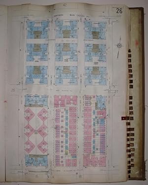
Vol. 12 of 29 Atlases of Insurance Maps for Brooklyn. Gravesend & Bensonhurst
Editore: Sanborn Map Company, New York, 1929
Da: Argosy Book Store, ABAA, ILAB, New York, NY, U.S.A.
Membro dell'associazione: ABAA ILAB
Valutazione del venditore 5 su 5 stelle
hardcover. Condizione: very good. Atlas. Lithograph with original hand coloring. Massive elephant folio. Decorative calligraphic titles, indices, and key maps. Contains a set of 78 detailed maps of southern Brooklyn along with changes recorded on paste-on correction slips through 1973. Quarter leather binding with gilt title on front and spine. Tear to spine of original protective canvas cover. This volume includes the new Belt Parkway ("Shore Parkway") and undeveloped waterfront land that is now filled-in parks and piers. The Sanborn map collection consists of a uniform series of large scale maps, dating from 1867 to the present depicting the commercial, industrial, and residential sections of some twelve thousand cities and towns in the United States, Canada, and Mexico. The maps were designed to assist fire insurance agents in determining the degree of hazard associated with a particular property and therefore show the size, shape and construction of dwellings, commercial buildings, and factories as well as fire walls locations of windows and doors, sprinkler systems, and types of roofs. The maps also indicate widths and names of streets, property boundaries, building use, and house and block numbers. They show locations of water mains, giving their dimensions, and of fire alarm boxes and hydrants. Sanborn maps are an unrivaled source of information about the structure and use of buildings in American Cities. The collection includes some fifty thousand editions of fire insurance maps comprising an estimated seven hundred thousand individual sheets. The Library of Congress holdings represent the largest extant collection of maps produced by the Sanborn Map Company. The majority of the maps were acquired by the Library through copyright deposit, but the collection was substantially enriched in 1967 when the Bureau of the Census transferred to the Library of Congress a complete set. The 1,899 loose-leaf binders were particularly noteworthy because they included later editions than those previously acquired by the Library. The Bureau of the Census set of maps had been regularly updated by printed, paste-on corrections supplied by the Sanborn Map Company, whereas the Library of Congress copies were retained in the form in which they were copyrighted.
-
Vol. 10 of 29 Atlases of Insurance Maps for Queens. Jackson Heights & East Elmhurst
Editore: Sanborn Map Company, New York, 1930
Da: Argosy Book Store, ABAA, ILAB, New York, NY, U.S.A.
Membro dell'associazione: ABAA ILAB
Valutazione del venditore 5 su 5 stelle
hardcover. Condizione: very good. Atlas. Lithograph with original hand coloring. Massive elephant folio. Decorative calligraphic titles, indices, and key maps. Contains a set of 94 maps along with changes recorded on paste-on correction slips through 1974. Quarter leather binding with gilt title on front and spine. Large tear to spine of original protective canvas cover. This volume includes the Brooklyn-Queens Expressway expansion which connected to Grand Central Parkway, the La Guardia Airport prior to runway extension, and original avenue names (Schurz, Patterson, Fillmore etc.). The Sanborn map collection consists of a uniform series of large scale maps, dating from 1867 to the present depicting the commercial, industrial, and residential sections of some twelve thousand cities and towns in the United States, Canada, and Mexico. The maps were designed to assist fire insurance agents in determining the degree of hazard associated with a particular property and therefore show the size, shape and construction of dwellings, commercial buildings, and factories as well as fire walls locations of windows and doors, sprinkler systems, and types of roofs. The maps also indicate widths and names of streets, property boundaries, building use, and house and block numbers. They show locations of water mains, giving their dimensions, and of fire alarm boxes and hydrants. Sanborn maps are an unrivaled source of information about the structure and use of buildings in American Cities. The collection includes some fifty thousand editions of fire insurance maps comprising an estimated seven hundred thousand individual sheets. The Library of Congress holdings represent the largest extant collection of maps produced by the Sanborn Map Company. The majority of the maps were acquired by the Library through copyright deposit, but the collection was substantially enriched in 1967 when the Bureau of the Census transferred to the Library of Congress a complete set. The 1,899 loose-leaf binders were particularly noteworthy because they included later editions than those previously acquired by the Library. The Bureau of the Census set of maps had been regularly updated by printed, paste-on corrections supplied by the Sanborn Map Company, whereas the Library of Congress copies were retained in the form in which they were copyrighted.
-
Vol. 6 of 29 Atlases of Insurance Maps for Queens. Downtown Jamaica & Morris Park
Editore: Sanborn Map Company, New York, 1925
Da: Argosy Book Store, ABAA, ILAB, New York, NY, U.S.A.
Membro dell'associazione: ABAA ILAB
Valutazione del venditore 5 su 5 stelle
hardcover. Condizione: very good. Atlas. Lithograph with original hand coloring. Massive elephant folio. Decorative calligraphic titles, indices, and key maps. Contains a set of 79 maps along with changes recorded on paste-on correction slips through 1970. Quarter leather binding with gilt title on front and spine. Tear to spine of original protective canvas cover. This volume includes part of Richmond Hill and the Van Wyck Expressway, and the original Jamaica Station on the Long Island Railroad at the current AirTrain Terminal on Sutphin Boulevard. The Sanborn map collection consists of a uniform series of large scale maps, dating from 1867 to the present depicting the commercial, industrial, and residential sections of some twelve thousand cities and towns in the United States, Canada, and Mexico. The maps were designed to assist fire insurance agents in determining the degree of hazard associated with a particular property and therefore show the size, shape and construction of dwellings, commercial buildings, and factories as well as fire walls locations of windows and doors, sprinkler systems, and types of roofs. The maps also indicate widths and names of streets, property boundaries, building use, and house and block numbers. They show locations of water mains, giving their dimensions, and of fire alarm boxes and hydrants. Sanborn maps are an unrivaled source of information about the structure and use of buildings in American Cities. The collection includes some fifty thousand editions of fire insurance maps comprising an estimated seven hundred thousand individual sheets. The Library of Congress holdings represent the largest extant collection of maps produced by the Sanborn Map Company. The majority of the maps were acquired by the Library through copyright deposit, but the collection was substantially enriched in 1967 when the Bureau of the Census transferred to the Library of Congress a complete set. The 1,899 loose-leaf binders were particularly noteworthy because they included later editions than those previously acquired by the Library. The Bureau of the Census set of maps had been regularly updated by printed, paste-on corrections supplied by the Sanborn Map Company, whereas the Library of Congress copies were retained in the form in which they were copyrighted.
-
Vol. 10A of 29 Atlases of Insurance Maps for Brooklyn. Kensington, South Prospect Park & Borough Park
Editore: Sanborn Map Company, New York, 1929
Da: Argosy Book Store, ABAA, ILAB, New York, NY, U.S.A.
Membro dell'associazione: ABAA ILAB
Valutazione del venditore 5 su 5 stelle
hardcover. Condizione: very good. Atlas. Lithograph with original hand coloring. Massive elephant folio. Decorative calligraphic titles, indices, and key maps. Contains a set of 76 detailed maps of southern Brooklyn along with changes recorded on paste-on correction slips through 1973. Quarter leather binding with gilt title on front and spine. Tear to spine and lower right corner of original protective canvas cover. This volume includes the terminus of Prospect Expressway, the underground route of the Long Island Railroad and Old Washington Cemetery. The Sanborn map collection consists of a uniform series of large scale maps, dating from 1867 to the present depicting the commercial, industrial, and residential sections of some twelve thousand cities and towns in the United States, Canada, and Mexico. The maps were designed to assist fire insurance agents in determining the degree of hazard associated with a particular property and therefore show the size, shape and construction of dwellings, commercial buildings, and factories as well as fire walls locations of windows and doors, sprinkler systems, and types of roofs. The maps also indicate widths and names of streets, property boundaries, building use, and house and block numbers. They show locations of water mains, giving their dimensions, and of fire alarm boxes and hydrants. Sanborn maps are an unrivaled source of information about the structure and use of buildings in American Cities. The collection includes some fifty thousand editions of fire insurance maps comprising an estimated seven hundred thousand individual sheets. The Library of Congress holdings represent the largest extant collection of maps produced by the Sanborn Map Company. The majority of the maps were acquired by the Library through copyright deposit, but the collection was substantially enriched in 1967 when the Bureau of the Census transferred to the Library of Congress a complete set. The 1,899 loose-leaf binders were particularly noteworthy because they included later editions than those previously acquired by the Library. The Bureau of the Census set of maps had been regularly updated by printed, paste-on corrections supplied by the Sanborn Map Company, whereas the Library of Congress copies were retained in the form in which they were copyrighted.
-
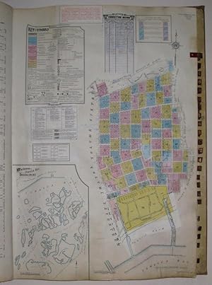
Vol. 17 of 29 Atlases of Insurance Maps for Brooklyn. Canarsie
Editore: Sanborn Map Company, New York, 1928
Da: Argosy Book Store, ABAA, ILAB, New York, NY, U.S.A.
Membro dell'associazione: ABAA ILAB
Valutazione del venditore 5 su 5 stelle
hardcover. Condizione: very good. Atlas. Lithograph with original hand coloring. Massive elephant folio. Decorative calligraphic titles, indices, and key maps. Contains a set of 101 detailed maps of eastern Brooklyn and Jamaica Bay along with changes recorded on paste-on correction slips through 1974. Quarter leather binding with gilt title on front and spine. Large tear to spine of original protective canvas cover. This volume includes Paerdegat and Fresh Creek Basins before artificial widening, Shore Parkway and the Long Island Railroad, and multiple pools, islets and marshes in Jamaica Bay. The Sanborn map collection consists of a uniform series of large scale maps, dating from 1867 to the present depicting the commercial, industrial, and residential sections of some twelve thousand cities and towns in the United States, Canada, and Mexico. The maps were designed to assist fire insurance agents in determining the degree of hazard associated with a particular property and therefore show the size, shape and construction of dwellings, commercial buildings, and factories as well as fire walls locations of windows and doors, sprinkler systems, and types of roofs. The maps also indicate widths and names of streets, property boundaries, building use, and house and block numbers. They show locations of water mains, giving their dimensions, and of fire alarm boxes and hydrants. Sanborn maps are an unrivaled source of information about the structure and use of buildings in American Cities. The collection includes some fifty thousand editions of fire insurance maps comprising an estimated seven hundred thousand individual sheets. The Library of Congress holdings represent the largest extant collection of maps produced by the Sanborn Map Company. The majority of the maps were acquired by the Library through copyright deposit, but the collection was substantially enriched in 1967 when the Bureau of the Census transferred to the Library of Congress a complete set. The 1,899 loose-leaf binders were particularly noteworthy because they included later editions than those previously acquired by the Library. The Bureau of the Census set of maps had been regularly updated by printed, paste-on corrections supplied by the Sanborn Map Company, whereas the Library of Congress copies were retained in the form in which they were copyrighted.
-
Vol. 18 of 29 Atlases of Insurance Maps for Brooklyn.Coney Island and Brighton Beach
Editore: Sanborn Map Company, New York, 1930
Da: Argosy Book Store, ABAA, ILAB, New York, NY, U.S.A.
Membro dell'associazione: ABAA ILAB
Valutazione del venditore 5 su 5 stelle
hardcover. Condizione: very good. Atlas. Lithograph with original hand coloring. Massive elephant folio. Decorative calligraphic titles, indices, and key maps. Contains a set of 86 detailed maps of southern Brooklyn along with changes recorded on paste-on correction slips through 1974. Quarter leather binding with gilt title on front and spine. Minor wear to spine of original protective canvas cover. This volume includes Sheepshead Bay, Shore Parkway, Gravesend Bay, Beach Line, the Boardwalk and the Cyclone. The Sanborn map collection consists of a uniform series of large scale maps, dating from 1867 to the present depicting the commercial, industrial, and residential sections of some twelve thousand cities and towns in the United States, Canada, and Mexico. The maps were designed to assist fire insurance agents in determining the degree of hazard associated with a particular property and therefore show the size, shape and construction of dwellings, commercial buildings, and factories as well as fire walls locations of windows and doors, sprinkler systems, and types of roofs. The maps also indicate widths and names of streets, property boundaries, building use, and house and block numbers. They show locations of water mains, giving their dimensions, and of fire alarm boxes and hydrants. Sanborn maps are an unrivaled source of information about the structure and use of buildings in American Cities. The collection includes some fifty thousand editions of fire insurance maps comprising an estimated seven hundred thousand individual sheets. The Library of Congress holdings represent the largest extant collection of maps produced by the Sanborn Map Company. The majority of the maps were acquired by the Library through copyright deposit, but the collection was substantially enriched in 1967 when the Bureau of the Census transferred to the Library of Congress a complete set. The 1,899 loose-leaf binders were particularly noteworthy because they included later editions than those previously acquired by the Library. The Bureau of the Census set of maps had been regularly updated by printed, paste-on corrections supplied by the Sanborn Map Company, whereas the Library of Congress copies were retained in the form in which they were copyrighted.
-
Vol. 9 of 29 Atlases of Insurance Maps for Queens. Woodside & Maspeth
Editore: Sanborn Map Company, New York, 1932
Da: Argosy Book Store, ABAA, ILAB, New York, NY, U.S.A.
Membro dell'associazione: ABAA ILAB
Valutazione del venditore 5 su 5 stelle
hardcover. Condizione: very good. Atlas. Lithograph with original hand coloring. Massive elephant folio. Decorative calligraphic titles, indices, and key maps. Contains a set of 73 maps along with changes recorded on paste-on correction slips through 1973. Quarter leather binding with gilt title on front and spine. Original protective canvas cover in very good condition. This volume includes Elmhurst Heights, the partially completed Brooklyn Queens Expressway ("Connecting Highway/Laurel Hill Blvd."), bordered on the south by the Queens-Midtown Expressway. The Sanborn map collection consists of a uniform series of large scale maps, dating from 1867 to the present depicting the commercial, industrial, and residential sections of some twelve thousand cities and towns in the United States, Canada, and Mexico. The maps were designed to assist fire insurance agents in determining the degree of hazard associated with a particular property and therefore show the size, shape and construction of dwellings, commercial buildings, and factories as well as fire walls locations of windows and doors, sprinkler systems, and types of roofs. The maps also indicate widths and names of streets, property boundaries, building use, and house and block numbers. They show locations of water mains, giving their dimensions, and of fire alarm boxes and hydrants. Sanborn maps are an unrivaled source of information about the structure and use of buildings in American Cities. The collection includes some fifty thousand editions of fire insurance maps comprising an estimated seven hundred thousand individual sheets. The Library of Congress holdings represent the largest extant collection of maps produced by the Sanborn Map Company. The majority of the maps were acquired by the Library through copyright deposit, but the collection was substantially enriched in 1967 when the Bureau of the Census transferred to the Library of Congress a complete set. The 1,899 loose-leaf binders were particularly noteworthy because they included later editions than those previously acquired by the Library. The Bureau of the Census set of maps had been regularly updated by printed, paste-on corrections supplied by the Sanborn Map Company, whereas the Library of Congress copies were retained in the form in which they were copyrighted.
-
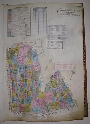
Vol. 12 of 29 Atlases of Insurance Maps for Queens. Bayside, Douglas Manor and Douglaston
Editore: Sanborn Map Company, New York, 1934
Da: Argosy Book Store, ABAA, ILAB, New York, NY, U.S.A.
Membro dell'associazione: ABAA ILAB
Valutazione del venditore 5 su 5 stelle
hardcover. Condizione: very good. Atlas. Lithograph with original hand coloring. Massive elephant folio. Decorative calligraphic titles, indices, and key maps. Contains a set of 91 maps along with changes recorded on paste-on correction slips through 1973. Quarter leather binding with gilt title on front and spine. Medium tear to spine of original protective canvas cover. This volume includes part of Auburndale and Little Neck, the border to Nassau County, Fort Totten, Clearview Golf Course, and the Horace Harding/Clearview Expressways Interchange. The Sanborn map collection consists of a uniform series of large scale maps, dating from 1867 to the present depicting the commercial, industrial, and residential sections of some twelve thousand cities and towns in the United States, Canada, and Mexico. The maps were designed to assist fire insurance agents in determining the degree of hazard associated with a particular property and therefore show the size, shape and construction of dwellings, commercial buildings, and factories as well as fire walls locations of windows and doors, sprinkler systems, and types of roofs. The maps also indicate widths and names of streets, property boundaries, building use, and house and block numbers. They show locations of water mains, giving their dimensions, and of fire alarm boxes and hydrants. Sanborn maps are an unrivaled source of information about the structure and use of buildings in American Cities. The collection includes some fifty thousand editions of fire insurance maps comprising an estimated seven hundred thousand individual sheets. The Library of Congress holdings represent the largest extant collection of maps produced by the Sanborn Map Company. The majority of the maps were acquired by the Library through copyright deposit, but the collection was substantially enriched in 1967 when the Bureau of the Census transferred to the Library of Congress a complete set. The 1,899 loose-leaf binders were particularly noteworthy because they included later editions than those previously acquired by the Library. The Bureau of the Census set of maps had been regularly updated by printed, paste-on corrections supplied by the Sanborn Map Company, whereas the Library of Congress copies were retained in the form in which they were copyrighted.
-
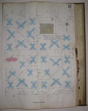
Vol. 16 of 29 Atlases of Insurance Maps for Brooklyn. Brownsville
Editore: Sanborn Map Company, New York, 1928
Da: Argosy Book Store, ABAA, ILAB, New York, NY, U.S.A.
Membro dell'associazione: ABAA ILAB
Valutazione del venditore 5 su 5 stelle
hardcover. Condizione: very good. Atlas. Lithograph with original hand coloring. Massive elephant folio. Decorative calligraphic titles, indices, and key maps. Contains a set of 64 detailed maps of Brooklyn along with changes recorded on paste-on correction slips through 1974. Quarter leather binding with gilt title on front and spine. Tear to spine of original protective canvas cover. This volume includes Kings Highway Extension and a corner of Evergreen Cemetery. The Sanborn map collection consists of a uniform series of large scale maps, dating from 1867 to the present depicting the commercial, industrial, and residential sections of some twelve thousand cities and towns in the United States, Canada, and Mexico. The maps were designed to assist fire insurance agents in determining the degree of hazard associated with a particular property and therefore show the size, shape and construction of dwellings, commercial buildings, and factories as well as fire walls locations of windows and doors, sprinkler systems, and types of roofs. The maps also indicate widths and names of streets, property boundaries, building use, and house and block numbers. They show locations of water mains, giving their dimensions, and of fire alarm boxes and hydrants. Sanborn maps are an unrivaled source of information about the structure and use of buildings in American Cities. The collection includes some fifty thousand editions of fire insurance maps comprising an estimated seven hundred thousand individual sheets. The Library of Congress holdings represent the largest extant collection of maps produced by the Sanborn Map Company. The majority of the maps were acquired by the Library through copyright deposit, but the collection was substantially enriched in 1967 when the Bureau of the Census transferred to the Library of Congress a complete set. The 1,899 loose-leaf binders were particularly noteworthy because they included later editions than those previously acquired by the Library. The Bureau of the Census set of maps had been regularly updated by printed, paste-on corrections supplied by the Sanborn Map Company, whereas the Library of Congress copies were retained in the form in which they were copyrighted.
-
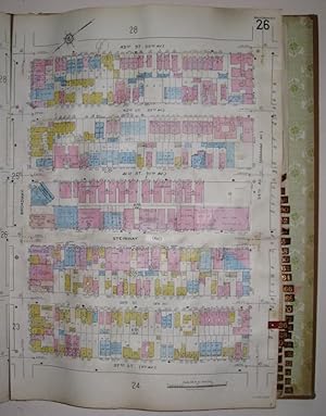
Vol. 2 of 29 Atlases of Insurance Maps for Queens. Astoria
Editore: Sanborn Map Company, New York, 1915
Da: Argosy Book Store, ABAA, ILAB, New York, NY, U.S.A.
Membro dell'associazione: ABAA ILAB
Valutazione del venditore 5 su 5 stelle
hardcover. Condizione: very good. Atlas. Lithograph with original hand coloring. Massive elephant folio. Decorative calligraphic titles, indices, and key maps. Contains a set of 89 detailed maps of Astoria along with changes recorded on paste-on correction slips through 1974. Quarter leather binding with gilt title on front and spine. Original protective canvas cover in good condition. This volume includes Astoria Boulevard leading to "Triborough Plaza/GCP", Hell Gate Rail Bridge. Indicates Triborough Bridge location, but map only shows the bridge extending halfway over Hell Gate. The Sanborn map collection consists of a uniform series of large scale maps, dating from 1867 to the present depicting the commercial, industrial, and residential sections of some twelve thousand cities and towns in the United States, Canada, and Mexico. The maps were designed to assist fire insurance agents in determining the degree of hazard associated with a particular property and therefore show the size, shape and construction of dwellings, commercial buildings, and factories as well as fire walls locations of windows and doors, sprinkler systems, and types of roofs. The maps also indicate widths and names of streets, property boundaries, building use, and house and block numbers. They show locations of water mains, giving their dimensions, and of fire alarm boxes and hydrants. Sanborn maps are an unrivaled source of information about the structure and use of buildings in American Cities. The collection includes some fifty thousand editions of fire insurance maps comprising an estimated seven hundred thousand individual sheets. The Library of Congress holdings represent the largest extant collection of maps produced by the Sanborn Map Company. The majority of the maps were acquired by the Library through copyright deposit, but the collection was substantially enriched in 1967 when the Bureau of the Census transferred to the Library of Congress a complete set. The 1,899 loose-leaf binders were particularly noteworthy because they included later editions than those previously acquired by the Library. The Bureau of the Census set of maps had been regularly updated by printed, paste-on corrections supplied by the Sanborn Map Company, whereas the Library of Congress copies were retained in the form in which they were copyrighted.
-

Wilmette 32
Editore: SanBorn Map Company, New York, 1938
Da: mediumraremaps.com, Franklin, TN, U.S.A.
Valutazione del venditore 4 su 5 stelle

Mappa
27 1/2 x 18 3/4 inches. Sunburn Map Company was founded after the Civil War for the purpose of providing detailed maps to facilitate insurance underwriting. Over the years it evolved into a monopoly. The company was able to survive the Great Depression. The maps were made available with recent updates on a current basis. The company continued publishing into the 1970s. This map is oa segment of Wilmette Illinois covering the east-west streets of Elmwood, Greenwood Ashland and Chestnut. The north-south street run from 11th street to Sheridan Road.The map is delightfully detailed with the real estate buildings and their editions. See pics. Very good mounted on archival backing paper.
-
CATALOGUE OF INSURANCE MAPS PUBLISHED BY SANBORN MAP COMPANY. 1926
Editore: Pelham, N. Y., 1926
Da: David M. Lesser, ABAA, Woodbridge, CT, U.S.A.
Membro dell'associazione: ABAA ESA ILAB SNEAB
Valutazione del venditore 5 su 5 stelle
Original green publisher's cloth [front cover slightly bowed], title stamped in gilt on front cover and spine. "Sixtieth Anniversary" stamped on front cover. [8], 296 pp. "This catalog contains a complete list of our latest publications," listing hundreds of titles. With Index, photo illustrations of the Sanborn offices, and a detailed listing of Sanborn atlases within each State and Mexico. Very Good. Ownership signature, "H. R. Deal | Sept. 14, 1926." All Sanborn works are rare, having been published in small numbers for the exclusive use of property insurance companies and underwriters. Painstakingly prepared from public records and the Sanborn Company's own surveying and research, a Sanborn work presents the most detailed pictorial history obtainable of an urban area. "We make a specialty of publishing diagrams and other insurance maps. Our invaluable basic data and original surveys or practically every city and town in the United States, together with our experienced organization, enable us to quote lower prices than obtainable elsewhere." According to OCLC this is the first Sanborn publication OCLC 7459064 [2- IL State Lib., Free Lib. of Phila.] as of January 2026.
-
![Immagine del venditore per New Haven Conn. Insurance Maps of Norwich Norwich-town, Connecticut 1926 Volume 4 [LeatherBound] venduto da True World of Books](https://pictures.abebooks.com/inventory/md/md31618331510.jpg)
New Haven Conn. Insurance Maps of Norwich Norwich-town, Connecticut 1926 Volume 4 [LeatherBound]
Data di pubblicazione: 2025
EUR 26,84
Spedizione gratuita
Spedito da India a U.S.A.Quantit�: 18 disponibili
Aggiungi al carrelloLeatherBound. Condizione: New. BOOKS ARE EXEMPT FROM IMPORT DUTIES AND TARIFFS; NO EXTRA CHARGES APPLY. LeatherBound edition. Condition: New. Reprinted from 1926 edition. Leather Binding on Spine and Corners with Golden leaf printing on spine. Bound in genuine leather with Satin ribbon page markers and Spine with raised gilt bands. A perfect gift for your loved ones. Pages: 108 NO changes have been made to the original text. This is NOT a retyped or an ocr'd reprint. Illustrations, Index, if any, are included in black and white. Each page is checked manually before printing. As this print on demand book is reprinted from a very old book, there could be some missing or flawed pages, but we always try to make the book as complete as possible. Fold-outs, if any, are not part of the book. If the original book was published in multiple volumes then this reprint is of only one volume, not the whole set. Sewing binding for longer life, where the book block is actually sewn (smythe sewn/section sewn) with thread before binding which results in a more durable type of binding. Pages: 108 Volume 4.


![Immagine del venditore per [ Redondo Beach Fire Insurance Atlas] Redondo Beach Los Angeles Co. Cal. venduto da Barry Lawrence Ruderman](https://pictures.abebooks.com/inventory/md/md32181778577.jpg)
![Immagine del venditore per Insurance Maps of Long Beach California [volumes 1-3, including Signal Hill and part of Lakewood] venduto da Barry Lawrence Ruderman](https://pictures.abebooks.com/inventory/md/md31937837370.jpg)