
Importo totale (1 articolo articoli):
Destinazione ordine:

ubd gregorys (192 risultati)
Vai alla pagina principale dei risultati di ricerca
Filtri di ricerca
Tipo di articolo
- Tutti i tipi di prodotto
- Libri (192)
- Riviste e Giornali (Nessun altro risultato corrispondente a questo perfezionamento)
- Fumetti (Nessun altro risultato corrispondente a questo perfezionamento)
- Spartiti (Nessun altro risultato corrispondente a questo perfezionamento)
- Arte, Stampe e Poster (Nessun altro risultato corrispondente a questo perfezionamento)
- Fotografie (Nessun altro risultato corrispondente a questo perfezionamento)
- Mappe (Nessun altro risultato corrispondente a questo perfezionamento)
- Manoscritti e Collezionismo cartaceo (Nessun altro risultato corrispondente a questo perfezionamento)
Condizioni Maggiori informazioni
- Nuovo (165)
- Come nuovo, Ottimo o Quasi ottimo (Nessun altro risultato corrispondente a questo perfezionamento)
- Molto buono o Buono (20)
- Discreto o Mediocre (Nessun altro risultato corrispondente a questo perfezionamento)
- Come descritto (7)
Legatura
Ulteriori caratteristiche
- Prima ed. (Nessun altro risultato corrispondente a questo perfezionamento)
- Copia autograf. (Nessun altro risultato corrispondente a questo perfezionamento)
- Sovracoperta (Nessun altro risultato corrispondente a questo perfezionamento)
- Con foto (65)
- Non Print on Demand (192)
Lingua (2)
Spedizione gratuita
Paese del venditore
Valutazione venditore
-

Hardcover. Condizione: Good.
-

EUR 3,86
Spedizione EUR 5,00
Spedito da Germania a U.S.A.Quantit�: 1 disponibili
Aggiungi al carrelloCondizione: good. Befriedigend/Good: Durchschnittlich erhaltenes Buch bzw. Schutzumschlag mit Gebrauchsspuren, aber vollst�ndigen Seiten. / Describes the average WORN book or dust jacket that has all the pages present.
-

Gippsland Discovery Map 386 5th ed: Wilsons Promontory
Lingua: Inglese
Editore: Universal Publishers Pty Ltd, 2013
ISBN 10: 073192746X ISBN 13: 9780731927463
Da: WorldofBooks, Goring-By-Sea, WS, Regno Unito
Valutazione del venditore 5 su 5 stelle

EUR 5,58
Spedizione EUR 6,43
Spedito da Regno Unito a U.S.A.Quantit�: 1 disponibili
Aggiungi al carrelloPaperback. Condizione: Very Good. The book has been read, but is in excellent condition. Pages are intact and not marred by notes or highlighting. The spine remains undamaged.
-
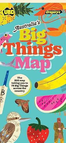
Australia's Big Things Map (Paperback)
Lingua: Inglese
Editore: Hardie Grant Explore, MaCquarie Park, 2022
ISBN 10: 0731932994 ISBN 13: 9780731932993
Da: Grand Eagle Retail, Bensenville, IL, U.S.A.
Valutazione del venditore 5 su 5 stelle
Paperback. Condizione: new. Paperback. Holidaymakers, vanlifers and roadtrippers across Australia agree that any road trip should include a stop at one of our beloved Big Things. Whether it's an oversized piece of fruit, an animal, sea creature, insect or other statue, AustraliasBig Things Map is here to help you create your ultimate checklist. This folded sheet map details 75 of the country's best giant novelties with a colourful and retro design. One side features a detailed map of Australia with an illustration of each Big Thing, and the other side includes the history and a few fun facts on each site, as well as a way to rate each oversized object you visit. Pin this entertaining map inside your van, or keep it in the glovebox, so you dont miss a single Big Mango, Merino or Murray Cod across Australia. Because lets face it: though their paint may be chipped and their features worn away, and whether you love them or begrudge their very existence, youre still likely to take a few selfies with one of Australia's Big Things while you're there. Discover 75 of the nation's favourite giant novelty icons and landmarks with the fully illustrated Australia Big Things Map. Shipping may be from multiple locations in the US or from the UK, depending on stock availability.
-

Australia Pocket Map 179 1st ed
Da: WorldofBooks, Goring-By-Sea, WS, Regno Unito
Valutazione del venditore 5 su 5 stelle
EUR 5,98
Spedizione EUR 6,43
Spedito da Regno Unito a U.S.A.Quantit�: 1 disponibili
Aggiungi al carrelloPaperback. Condizione: Very Good. The book has been read, but is in excellent condition. Pages are intact and not marred by notes or highlighting. The spine remains undamaged.
-

EUR 2,87
Spedizione EUR 5,00
Spedito da Germania a U.S.A.Quantit�: 1 disponibili
Aggiungi al carrelloCondizione: very good. Gut/Very good: Buch bzw. Schutzumschlag mit wenigen Gebrauchsspuren an Einband, Schutzumschlag oder Seiten. / Describes a book or dust jacket that does show some signs of wear on either the binding, dust jacket or pages.
-

EUR 2,87
Spedizione EUR 5,00
Spedito da Germania a U.S.A.Quantit�: 1 disponibili
Aggiungi al carrelloCondizione: good. Befriedigend/Good: Durchschnittlich erhaltenes Buch bzw. Schutzumschlag mit Gebrauchsspuren, aber vollst�ndigen Seiten. / Describes the average WORN book or dust jacket that has all the pages present.
-

EUR 2,87
Spedizione EUR 5,00
Spedito da Germania a U.S.A.Quantit�: 2 disponibili
Aggiungi al carrelloCondizione: good. Befriedigend/Good: Durchschnittlich erhaltenes Buch bzw. Schutzumschlag mit Gebrauchsspuren, aber vollst�ndigen Seiten. / Describes the average WORN book or dust jacket that has all the pages present.
-

EUR 3,86
Spedizione EUR 5,00
Spedito da Germania a U.S.A.Quantit�: 1 disponibili
Aggiungi al carrelloCondizione: very good. Gut/Very good: Buch bzw. Schutzumschlag mit wenigen Gebrauchsspuren an Einband, Schutzumschlag oder Seiten. / Describes a book or dust jacket that does show some signs of wear on either the binding, dust jacket or pages.
-

EUR 3,86
Spedizione EUR 5,00
Spedito da Germania a U.S.A.Quantit�: 1 disponibili
Aggiungi al carrelloCondizione: good. Befriedigend/Good: Durchschnittlich erhaltenes Buch bzw. Schutzumschlag mit Gebrauchsspuren, aber vollst�ndigen Seiten. / Describes the average WORN book or dust jacket that has all the pages present.
-

Australia Pocket Map 179 4th ed (Folded)
Da: Grand Eagle Retail, Bensenville, IL, U.S.A.
Valutazione del venditore 5 su 5 stelle
Folded. Condizione: new. Folded. National Map Handy pocket size map of Australia Australia map projection-Lamberts conformal conic at a scale of 1:5 800 000 Features eastern and middle Australia on 1 side (Queensland, New South Wales,Victoria, Northern Territory, South Australia and Tasmania) and western and middle Australia on the other side (Western Australia, Northern Territory and South Australia) Also includes index to cities and towns Shipping may be from multiple locations in the US or from the UK, depending on stock availability.
-
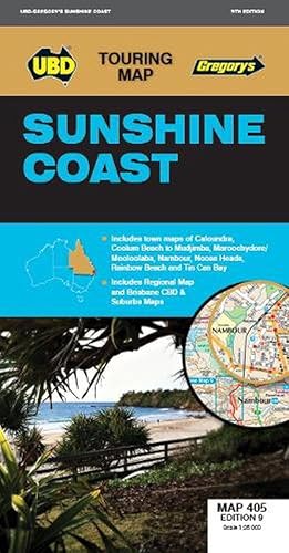
Sunshine Coast Map 405 9th (Folded)
Lingua: Inglese
Editore: Hardie Grant Explore, MaCquarie Park, 2023
ISBN 10: 073193282X ISBN 13: 9780731932825
Da: Grand Eagle Retail, Bensenville, IL, U.S.A.
Valutazione del venditore 5 su 5 stelle
Folded. Condizione: new. Folded. The latest edition of the Sunshine Coast touring map has been fully revised and updated and includes: Sunshine Coast regional mapping at a scale of 1 : 171 950 and index covering along the coast from Inskip Peninsula in the north to Caloundra and Toorbul in the south, Wonga Lower in the west and Noosa Heads and Caloundra in the east. Street level mapping at a scale of 1 : 25 000 with coverage for Caloundra and surrounding suburbs, Maroochydore Mooloolaba and surrounding suburbs, Nambour, Noosa Heads Noosaville Sunshine Beach, Peregian Beach to Mudjimba, Rainbow Beach and Tin Can Bay. There is also a list of Visitor Information Centres. With all the information that is contained in the handy fold out map it is ideal for use when exploring the Sunshine Coast. Shipping may be from multiple locations in the US or from the UK, depending on stock availability.
-
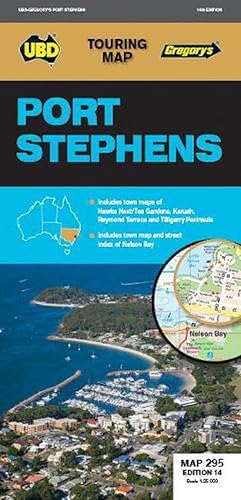
Port Stephens Map 295 14th ed (Folded)
Lingua: Inglese
Editore: Universal Publishers, MaCquarie Park, 2019
ISBN 10: 0731931912 ISBN 13: 9780731931910
Da: Grand Eagle Retail, Bensenville, IL, U.S.A.
Valutazione del venditore 5 su 5 stelle
Folded. Condizione: new. Folded. The latest edition of the Port Stephens touring map has been fully revised and updated and features: A regional touring map covering Port Stephens, Hawks Nest/Tea Gardens, Karuah, Lemon Tree Passage and Raymond Terrace. Maps and street index of Nelson Bay and surrounding suburbs. Maps of Hawks Nest/Tea Gardens, Karuah, Raymond Terrace and Tilligerry Peninsula (Lemon Tree Passage, Mallabula, Tanilba Bay). Regional touring attractions and advertisers index. With all this information contained in the handy fold out map this is an essential mapping tool for both the local or tourist. Shipping may be from multiple locations in the US or from the UK, depending on stock availability.
-

Sydney to Brisbane Map 244 10th ed (Folded)
Da: Grand Eagle Retail, Bensenville, IL, U.S.A.
Valutazione del venditore 5 su 5 stelle
Folded. Condizione: new. Folded. The latest edition of the Sydney to Brisbane touring map has been fully revised and updated and includes: Information on travelling from Sydney to Brisbane via both the Pacific Motorway/Highway and the New England Highway. Information on choosing to travel between Sydney and Brisbane via either the Pacific or New England Highways. State mapping with both routes highlighted. 2 x separate strip maps for each route with information on the major towns along each route. Visitor Information Centre locations, addresses and contact information. With all this information contained in one handy fold out map this is an essential tool when travelling between Sydney and Brisbane. Shipping may be from multiple locations in the US or from the UK, depending on stock availability.
-

Darwin & the Top End Map 590 22nd ed (Folded)
Da: Grand Eagle Retail, Bensenville, IL, U.S.A.
Valutazione del venditore 5 su 5 stelle
Folded. Condizione: new. Folded. The latest edition of the Darwin and the Top End touring map has been fully revised and updated and is a very useful tool to have when travelling in the area. There are regional touring maps covering Darwin in the north, Katherine and Mataranka in the south, as well as Daly River, Kakadu & Litchfield National Parks. Also featured are maps and a street index of Darwin & Palmerston city centres and surrounding suburbs; maps of Jabiru, Katherine and Kakadu and Litchfield National Parks, and a regional touring attractions and advertisers index. Shipping may be from multiple locations in the US or from the UK, depending on stock availability.
-
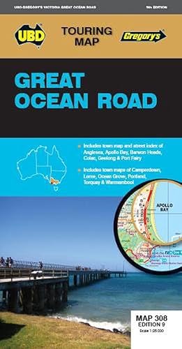
Great Ocean Road Map 308 9th (Folded)
Lingua: Inglese
Editore: Hardie Grant Explore, MaCquarie Park, 2022
ISBN 10: 0731932773 ISBN 13: 9780731932771
Da: Grand Eagle Retail, Bensenville, IL, U.S.A.
Valutazione del venditore 5 su 5 stelle
Folded. Condizione: new. Folded. The latest edition of the Great Ocean Road touring map has been fully revised & updated is an essential tool to have at hand when travelling around the Great Ocean Road area.With regional map coverage from Ararat in the north, Nelson, Apollo Bay and Ocean Grove in the south, Wallan in the east and Mt Gambier (SA) in the west.There are also 12 street level maps for Anglesea, Apollo Bay, Barwon Heads, Camperdown, Colac, Geelong (which also includes a street index), Lorne, Ocean Grove, Port Fairy, Portland, Torquay and Warrnambool.There is also a list of regional touring attractions.With all this information contained in this one handy sized fold out map this is an essential tool to have when travelling in and around the Great Ocean Road. Shipping may be from multiple locations in the US or from the UK, depending on stock availability.
-

Gippsland Discovery Map 386 8th ed (Folded)
Lingua: Inglese
Editore: Universal Publishers, MaCquarie Park, 2020
ISBN 10: 0731932331 ISBN 13: 9780731932337
Da: Grand Eagle Retail, Bensenville, IL, U.S.A.
Valutazione del venditore 5 su 5 stelle
Folded. Condizione: new. Folded. This newest edition of the Gippsland Discovery and Wilsons Promontory touring map is an essential tool to use when travelling in the area. With a regional map and towns index covering Buxton in the north, Wilsons Promontory in the south, Heyfield in the east and Craigieburn in the south. There is also street level mapping and town descriptions for the towns of Churchill, Cowes, Inverloch, Korumburra, Leongatha, Moe, Morwell, Traralgon, Warragul and Yarram and town maps of Drouin and Trafalgar. Phillip Island is also covered with street maps of Cowes, Newhaven, San Remo, Smiths Beach and Summerlands. There are detailed descriptions of the top attractions and activities throughout the region and a list of Visitor Information Centres. Shipping may be from multiple locations in the US or from the UK, depending on stock availability.
-

New South Wales State & Suburban Map 270 31st ed (Folded)
Da: Grand Eagle Retail, Bensenville, IL, U.S.A.
Valutazione del venditore 5 su 5 stelle
Folded. Condizione: new. Folded. The latest edition of the New South Wales state and suburban map has been fully revised and updated. It includes state mapping at a scale of 1: 1 600 000 plus an index to towns and localities on one side and on the other side there is Sydney and surrounds suburban coverage north to Gosford, south to Douglas Park and Stanwell Park, along the coast from Palm Beach to Coalcliff and west to Springwood plus an index to the suburbs and localities included on this map. With all this information contained in this handy fold up map this is an essential tool when travelling around New South Wales and the Sydney region. Shipping may be from multiple locations in the US or from the UK, depending on stock availability.
-

Canberra Suburban Streets Map 259 41st Ed (Folded)
Da: Grand Eagle Retail, Bensenville, IL, U.S.A.
Valutazione del venditore 5 su 5 stelle
Folded. Condizione: new. Folded. The latest edition of the Canberra Suburban Streets Map has been fully revised and updated and includes street level mapping, suburbs and a street index of Canberra, with coverage north to Casey and south to Banks. Queanbeyan is also covered on this map. There is also detailed coverage of Capital Hill and Canberra City, Australian National University, as well as Belconnen and Woden town centres. This handy map is an essential tool for finding your way around Canberra. Shipping may be from multiple locations in the US or from the UK, depending on stock availability.
-

Central Coast Suburban Streets Map 289 16th ed (Folded)
Da: Grand Eagle Retail, Bensenville, IL, U.S.A.
Valutazione del venditore 5 su 5 stelle
Folded. Condizione: new. Folded. The latest edition of the Central Coast Suburban Streets map has been fully revised and updated with over 100 new streets being added. This conveniently sized fold out map features detailed street directory mapping of the Central Coast at a scale of 1:25 000 with coverage from Doyalson in the north, Patonga in the south, along the coast from Budgewoi Peninsula to Box Head and Kariong in the west. Also included are a street index and index for suburbs and localities making it an essential tool to have at hand when travelling in this area. Shipping may be from multiple locations in the US or from the UK, depending on stock availability.
-

Melbourne City Streets & Suburbs Map 362 8th ed (Folded)
Da: Grand Eagle Retail, Bensenville, IL, U.S.A.
Valutazione del venditore 5 su 5 stelle
Folded. Condizione: new. Folded. The latest edition of the Melbourne City streets and suburbs city map has been fully revised and updated. It includes Melbourne suburban coverage north to Sunbury, east to Healesville, south to Flinders and west to Melton plus suburban coverage for Geelong and the Bellarine Peninsula, Phillip Island plus a suburbs & localities index on one side and on the other side there is street level mapping for Melbourne and surrounding suburbs at a scale of 1: 25 000 plus a suburbs and localities index. With all this information contained in this handy map it is an essential tool when travelling around Melbourne and the surrounding region. Shipping may be from multiple locations in the US or from the UK, depending on stock availability.
-

Tasmania State & Suburban Map 770 29th ed (Folded)
Da: Grand Eagle Retail, Bensenville, IL, U.S.A.
Valutazione del venditore 5 su 5 stelle
Folded. Condizione: new. Folded. The latest edition of the Tasmania state and suburban map has been fully revised and updated and includes: State map & index to towns and localities Suburban map coverage of Hobart north to Mangalore and Runnymede south to Oyster Cove and South Arm, east to Sorell and west to Molesworth and an index to the Suburbs & Localities included in the coverage. Shipping may be from multiple locations in the US or from the UK, depending on stock availability.
-

Geelong Suburban Streets Map 385 15th (Folded)
Da: Grand Eagle Retail, Bensenville, IL, U.S.A.
Valutazione del venditore 5 su 5 stelle
Folded. Condizione: new. Folded. The latest edition of the Geelong Suburban Map has been fully revised and updated and includes a Geelong city map at a scale of 1: 12 500. Street maps plus a suburb and street index covering Geelong and its surrounding suburbs from Lara in the north to Grovedale and Leopold in the south on one side of the map. Included on the other side are street maps plus suburbs and street index for the Bellarine Peninsula including Clifton Springs, Point Lonsdale, Portarlington, Queenscliff, Saint Leonards and Ocean Grove plus Barwon Heads. This handy sized fold up map is the ideal reference tool to help you find you way around Geelong and the Bellarine Peninsula for both the local or tourist alike. Shipping may be from multiple locations in the US or from the UK, depending on stock availability.
-

Albury Wodonga Murray River High Country Map 381 20th ed (Folded)
Lingua: Inglese
Editore: Universal Publishers, MaCquarie Park, 2022
ISBN 10: 073193248X ISBN 13: 9780731932481
Da: Grand Eagle Retail, Bensenville, IL, U.S.A.
Valutazione del venditore 5 su 5 stelle
Folded. Condizione: new. Folded. The latest edition of the Albury Wodonga Murray River and High Country touring map has been fully revised and updated and includes regional touring coverage from Finley and Henty in the north, Euroa and Mount Beauty in the south, Darbyshire in the east and Numurkah in the west. There is also street level mapping and indexes for Albury, Wangaratta and Wodonga and street level mapping for the towns of Barooga, Beechworth, Benalla, Bright, Cobram, Corowa, Euroa, Mount Beauty, Myrtleford, Numurkah, Rutherglen, , Tocumwal, Yarrawonga and Mulwala. There is also a list of touring attractions for the region. With all this information and so many towns included on this handy map this is an essential tool for the tourist and local when travelling in the Albury Wodonga, Murray River and High Country region. Shipping may be from multiple locations in the US or from the UK, depending on stock availability.
-

Wagga Wagga & The Riverina Map 284 21st ed (Folded)
Lingua: Inglese
Editore: Universal Publishers, MaCquarie Park, 2018
ISBN 10: 0731931726 ISBN 13: 9780731931729
Da: Grand Eagle Retail, Bensenville, IL, U.S.A.
Valutazione del venditore 5 su 5 stelle
Folded. Condizione: new. Folded. The latest edition of the Wagga Wagga and the Riverina touring map has been fully revised and updated and includes a regional touring map covering West Wyalong and Cowra in the north, Culcairn in the south, Yass in the east and Griffith in the west. Also featured are detailed street level maps and indexes for Cootamundra, Griffith, Leeton, Wagga Wagga Forest Hill and Young and detailed street level mapping for the towns of Gundagai, Junee, Narrandera, Temora, Tumut, West Wyalong Wyalong and Yass. Also included is a list of touring attractions and advertisers index. With all this information contained in this handy fold up map it is an essential tool when travelling through this region. Shipping may be from multiple locations in the US or from the UK, depending on stock availability.
-

Maryborough Hervey Bay Bundaberg Map 486/480 5th (Folded)
Da: Grand Eagle Retail, Bensenville, IL, U.S.A.
Valutazione del venditore 5 su 5 stelle
Folded. Condizione: new. Folded. The latest edition of theMaryborough Hervey Bay Bundaberg Map is a handy tool for both the tourist and locals wanting to find their way around the area. It has been fully revised and updated and includes: A regional touring map covering along the coast from Broadwater Conservation Park in the north and Peregian Springs in the south, Inland from Bulburin National Park in the north and Kingaroy in the south, and west to Gayndah, with Fraser Island also included; Maps and street indexes for Bundaberg, Hervey Bay and Maryborough; Maps of Bargara, Childers, Gayndah, Moore Park Beach, Rainbow Beach and Tin Can Bay; and a list of regional touring attractions and advertisers. Shipping may be from multiple locations in the US or from the UK, depending on stock availability.
-
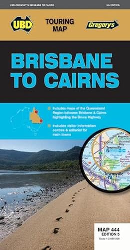
Brisbane to Cairns Map 444 5th ed (Folded)
Lingua: Inglese
Editore: Universal Publishers, MaCquarie Park, 2017
ISBN 10: 0731931157 ISBN 13: 9780731931156
Da: Grand Eagle Retail, Bensenville, IL, U.S.A.
Valutazione del venditore 5 su 5 stelle
Folded. Condizione: new. Folded. The 5th Edition of the Brisbane to Cairns touring map will help you with your travels along the Queensland coast. It includes a Queensland state map highlighting the Bruce Highway from Brisbane to Cairns, strip maps featuring the best of the Bruce Highway, and visitor and touring information. Shipping may be from multiple locations in the US or from the UK, depending on stock availability.
-

Northern Territory State & Suburban Map 571 15th ed (Folded)
Da: Grand Eagle Retail, Bensenville, IL, U.S.A.
Valutazione del venditore 5 su 5 stelle
Folded. Condizione: new. Folded. The latest edition of the Northern Territory State and Suburban map has been fully revised and updated Coverage includes a detailed Territory map on one side with information on accommodation, caravan parks, camping and fuel. The other side offers coverage of Darwin and its surrounding suburbs with an index to the towns included plus an index to the Northern Territory towns and localities then a map of Aboriginal Land and National Parks of the Northern Territory. Other content includes a Northern Territory fact file and detailed indexes. There is so much information contained in this handy fold out map you should not be travelling in the Northern Territory or Darwin without it. Shipping may be from multiple locations in the US or from the UK, depending on stock availability.
-

Western Australia State & Suburban Map 670 17th ed (Folded)
Da: Grand Eagle Retail, Bensenville, IL, U.S.A.
Valutazione del venditore 5 su 5 stelle
Folded. Condizione: new. Folded. The latest edition of the Western Australia State and Suburban map has been fully revised and updated and includes:Suburban map coverage of Perth and surrounds, north to Ridgewood, south to Halls Head and North Dandalup, and east to the Lakes, Karragullen and Gleneagle (including insets of Yanchep and Pinjarra) with an index to the suburbs and localities included on this map.State map and index to towns, localities and homesteads with a section on South West Western Australia at a scale of 1: 870 000.With the quality and clarity you have come to expect from a UBD Gregorys map this is an essential tool for navigating your way around Western Australia, Perth, Rockingham and Mandurah. Shipping may be from multiple locations in the US or from the UK, depending on stock availability.
-

Ballarat Grampians & Spa Country Map 382 18th (Folded)
Lingua: Inglese
Editore: Universal Publishers, MaCquarie Park, 2022
ISBN 10: 0731932978 ISBN 13: 9780731932979
Da: Grand Eagle Retail, Bensenville, IL, U.S.A.
Valutazione del venditore 5 su 5 stelle
Folded. Condizione: new. Folded. The latest edition of the Ballarat Grampians & Spa Country Map has been fully revised and updated. It includes street level mapping and street index for Ballarat on one side. On the reverse side is a regional touring map which covers Harcourt & Campbells Bridge in the north, Cressy in the south, Romsey in the east and Wartook and Dunkeld in the west. It also includes maps & indexes for Ararat, Creswick, Daylesford Hepburn Springs, Kyneton, Stawell and Woodend and a map of Halls Gap. There is also a list of regional touring attractions. This handy fold out map is an essential tool to have at hand whether you are living in or touring the region. Shipping may be from multiple locations in the US or from the UK, depending on stock availability.