Washington 1890 (4 risultati)

- Brossura
Da: THE SAINT BOOKSTORE, Southport, , Regno UnitoTHE SAINT BOOKSTORE
Contatta il venditoreVenditore con 5 stelleCondizione: Nuovo
EUR 31,90
EUR 21,48 spedizioneSpedito da Regno Unito a U.S.A.Quantità: Più di 20 disponibili
Paperback. Condizione: New. New copy - Usually dispatched within 4 working days.
 Altre immagini
Proceedings of a National Convention of Railroad Commissioners
Held At The Office Of The Interstate Commerce Commission; Washington, D. C., May 28, 29, 1890
- Brossura
- Print on Demand
Da: Forgotten Books, London, Regno UnitoForgotten Books
Contatta il venditoreVenditore con 4 stelleCondizione: Nuovo
EUR 17,19
Spedizione gratuitaSpedito da Regno Unito a U.S.A.Quantità: Più di 20 disponibili
Paperback. Condizione: New. Print on Demand. This book has a particular interest in the intricate subject of railroad legislation and regulation within the United States. The text focuses on discussions from a convention held to encourage harmony in legislation and regulation across different states and the national level. Atten…dees considered topics such as state versus federal regulation, the Railway Accounting Officers' uniform accounting principles, and the proposal for automatic couplers on all freight cars. The author presents the complexities of regulating an industry that straddles state lines, discusses arguments for federal versus state control, and explores the need for uniform accounting standards. This volume provides valuable insights into the ongoing challenges and debates surrounding railroad regulation in the United States. Its analysis remains relevant today as the rail industry continues to evolve and adapt to changing economic and technological conditions. This book is a reproduction of an important historical work, digitally reconstructed using state-of-the-art technology to preserve the original format. In rare cases, an imperfection in the original, such as a blemish or missing page, may be replicated in the book. print-on-demand item.
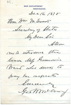
Editore: 16 December On letterhead of the War Department Washington 1878
- Manoscritto
Da: Richard M. Ford Ltd, London, , Regno UnitoRichard M. Ford Ltd
Contatta il venditoreVenditore con 5 stelleCondizione: Usato
EUR 57,27
EUR 5,21 spedizioneSpedito da Regno Unito a U.S.A.Quantità: 1 disponibili
12mo, 1 p. Good, on ruled paper. A note of introduction for the bearer, Miss Ward [Genevieve Ward, actress].

Whitney's Map of the City of Spokane Falls and Environs, Washington.
1890 Whitney / Ashley City Plan or Map of Spokane, Washington
- Mappa
Da: Geographicus Rare Antique Maps, Brooklyn, NY, U.S.A.Geographicus Rare Antique Maps
Contatta il venditoreVenditore con 4 stelleCondizione: Usato
EUR 1794,20
EUR 14,69 spedizioneSpedito in U.S.A.Quantità: 1 disponibili
Very good. Light wear along original fold lines. Manuscript notations on recto. Size 28.25 x 27.5 Inches. This is the W. H. Whitney / John K. Ashley 1890 map of Spokane, Washington, one of the earliest obtainable maps of that city. Published when Spokane was known as Spokane Falls, the map is laid out as a cadastral, allowing fo…r a detailed view into the early development of the city. It further combines the functions of a real estate map and a railroad map. A Closer Look Streets are identified, city blocks are numbered, and the numerous additions and private land holdings are shaded. Dashed lines trace the routes of the 'Seattle, Lake Shore, and Eastern Railroad', the 'Spokane Falls and Northern Railroad', and the 'Northern Pacific Railroad' through town, along with along with 'cable roads' and a 'motor line'. A beautiful vignette view of Spokane Falls appears just below the title on the right. Below, in the lower right, statistics underscore the growing city's prosperity. A further inset map situates it within the Pacific Northwest. Manuscript Notations Ink and pencil manuscript notations mark the eastern and southern city limits. Other manuscript notations delineate land purchases in East Spokane: two individuals purchased five-acre tracts in that part of the city. The Great Spokane Fire The Great Spokane Fire occurred on August 4, 1889, a year before this map was published. The fire burned over 30 city blocks, destroyed Spokane's downtown commercial district, and caused millions in damage. Spokane had been experiencing a boom era thanks to gold strikes in nearby Idaho (along with other ore strikes) and being a railroad hub. Downtown Spokane was rebuilt quickly, and in 1891 the city was reincorporated at 'Spokane' instead of 'Spokane Falls'. The Union Pacific Shield The Union Pacific shield appears in the lower left, prominently advertising Union Pacific Overland Route connections to Omaha, Nebraska and San Francisco, California. Jointly operated by the Union Pacific and Central Pacific, the Overland Route was the first transcontinental railroad. A second transcontinental route was completed in mid-1883 after the Northern Pacific finished its route between St. Paul and Wallula, Washington. The 'Oregon Railroad and Navigation Company' completed a network from Wallula to Portland, which agreed to operate Northern Pacific traffic. In 1886, the 'Oregon Railway and Navigation Company' was leased to the Union Pacific, and within a couple of years the Union Pacific owned half of 'Oregon Railway and Navigation Company' shares through a holding company with ties to the Northern Pacific. By 1889, a branch line opened to Spokane. The Union Pacific's contracted William Henry Whitney to produce a series of maps of western cities, to promote land development in along the tracks. W. H. Whitney Maps Between 1889 and 1890, W. H. Whitney issued a series of separate-issue large-scale pocket maps of western cities serviced by the first the Rio Grande Western, then, the Union Pacific and Northern Pacific Railroads. These include Salt Lake City, Portland, Seattle, Astoria, Spokane, Port Townsend, Bellingham Bay, and Tacoma. There are potentially others. They are the work of various surveyors, civil engineers, military surveyors, railroad engineers, and local land offices, compiled locally then sent to Philadelphia for engraving and printing. Most were engraved by Louis Humphrey Everts, some in partnership with 'Howell', as 'Everts and Howell'. The maps universally bear the distinctive logos of either the Rio Grande Western or the Union Pacific 'Overland Route', suggesting that the railroads at least partially financed their production. They were further designed to bear local advertising, which varies from example to example. The maps also, universally, bear the copyright of 'W. H. Whitney', filed in Washington D.C. While we cannot be certain, we believe this may be the Boston civil engineer William Henry Whitney, who, after 1888, owned a privat.


