
9781782750864 - western crete tour & trail super-durable map di kostura, jan (25 risultati)

- Brossura
Da: Rarewaves.com USA, London, LONDO, Regno UnitoRarewaves.com USA
Contatta il venditoreVenditore con 5 stelleCondizione: Nuovo
EUR 15,50
Spedizione gratuitaSpedito da Regno Unito a U.S.A.Quantità: 15 disponibili
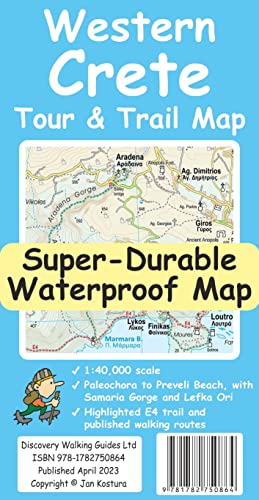
Paperback. Condizione: New. For your best adventures, use the best map. Water-proof, split-proof, tear-proof. Western Crete Tour and Trail Super-Durable Map is simply the toughest, most accurate, easy to read, easy to use map that you can buy at any price. A large 960mm by 694mm double sided map sheet at 1:40,000 scale covers ar…ea of over 1600km2, from Paleochora in the west to Preveli beach in the east. The map covers the most important hiking regions in the western Crete, including the famous Samaria Gorge, Lefka Ori (White Mountains) and much more. Our legendary 'Tour and Trail' level of detail ranges from major roads to secondary roads to minor roads to streets and narrow country roads, plus dirt roads, tracks and walking trails. Place names are in English and Greek to aid your navigation. Altitude shading is designed to clearly show the altitude range when travelling across the island by car or on foot. 20-metre and 100-metre contours combined with altitude shading bring this beautiful landscape to life. There are plenty of individual height points and all of the official 'Trig' points are on the map. Tour and Trail attention to detail includes our useful symbol range including viewpoints, picnic areas, petrol stations, bar/restaurants and parking areas where you can pull off the road safely. You will easily identify springs, caves, sports grounds, cemeteries, monasteries, churches, chapels, lighthouses, forts, camping areas, waterfalls, wind turbines, windmills, hotels etc. For walkers, the E4 long distance walking route is specially highlighted on the map in red. Published walking routes are highlighted in green. It all adds up to the most detailed, most durable map of Western Crete that you can buy anywhere. 'Super-Durable' means a waterproof, tear-proof, map that can take the roughest treatment and still folds up like new after your adventures. Super-Durable Maps come with a 2-year adventurous use 'Wear and Tear' guarantee. DWG's special concertina map fold makes our map easy to open and easy to refold back to its 232mm by 120mm size. Digital editions of our Western Crete Tour and Trail Map are available as in-app purchases for Outdooractive, Locus Map and Avenza apps.

- Brossura
Da: Rarewaves USA, OSWEGO, IL, U.S.A.Rarewaves USA
Contatta il venditoreVenditore con 5 stelleCondizione: Nuovo
EUR 16,41
Spedizione gratuitaSpedito in U.S.A.Quantità: 15 disponibili
Paperback. Condizione: New. For your best adventures, use the best map. Water-proof, split-proof, tear-proof. Western Crete Tour and Trail Super-Durable Map is simply the toughest, most accurate, easy to read, easy to use map that you can buy at any price. A large 960mm by 694mm double sided map sheet at 1:40,000 scale covers ar…ea of over 1600km2, from Paleochora in the west to Preveli beach in the east. The map covers the most important hiking regions in the western Crete, including the famous Samaria Gorge, Lefka Ori (White Mountains) and much more. Our legendary 'Tour and Trail' level of detail ranges from major roads to secondary roads to minor roads to streets and narrow country roads, plus dirt roads, tracks and walking trails. Place names are in English and Greek to aid your navigation. Altitude shading is designed to clearly show the altitude range when travelling across the island by car or on foot. 20-metre and 100-metre contours combined with altitude shading bring this beautiful landscape to life. There are plenty of individual height points and all of the official 'Trig' points are on the map. Tour and Trail attention to detail includes our useful symbol range including viewpoints, picnic areas, petrol stations, bar/restaurants and parking areas where you can pull off the road safely. You will easily identify springs, caves, sports grounds, cemeteries, monasteries, churches, chapels, lighthouses, forts, camping areas, waterfalls, wind turbines, windmills, hotels etc. For walkers, the E4 long distance walking route is specially highlighted on the map in red. Published walking routes are highlighted in green. It all adds up to the most detailed, most durable map of Western Crete that you can buy anywhere. 'Super-Durable' means a waterproof, tear-proof, map that can take the roughest treatment and still folds up like new after your adventures. Super-Durable Maps come with a 2-year adventurous use 'Wear and Tear' guarantee. DWG's special concertina map fold makes our map easy to open and easy to refold back to its 232mm by 120mm size. Digital editions of our Western Crete Tour and Trail Map are available as in-app purchases for Outdooractive, Locus Map and Avenza apps.

- Brossura
Da: Grand Eagle Retail, Bensenville, IL, U.S.A.Grand Eagle Retail
Contatta il venditoreVenditore con 5 stelleCondizione: Nuovo
EUR 16,81
Spedizione gratuitaSpedito in U.S.A.Quantità: 1 disponibili
Paperback. Condizione: new. Paperback. For your best adventures, use the best map. Water-proof, split-proof, tear-proof. Western Crete Tour & Trail Super-Durable Map is simply the toughest, most accurate, easy to read, easy to use map that you can buy at any price. A large 960mm by 694mm double sided map sheet at 1:40,000 scale…covers area of over 1600km2, from Paleochora in the west to Preveli beach in the east. The map covers the most important hiking regions in the western Crete, including the famous Samaria Gorge, Lefka Ori (White Mountains) and much more. Our legendary 'Tour & Trail' level of detail ranges from major roads to secondary roads to minor roads to streets and narrow country roads, plus dirt roads, tracks and walking trails. Place names are in English and Greek to aid your navigation. Altitude shading is designed to clearly show the altitude range when travelling across the island by car or on foot. 20-metre and 100-metre contours combined with altitude shading bring this beautiful landscape to life. There are plenty of individual height points and all of the official 'Trig' points are on the map. Tour & Trail attention to detail includes our useful symbol range including viewpoints, picnic areas, petrol stations, bar/restaurants and parking areas where you can pull off the road safely. You will easily identify springs, caves, sports grounds, cemeteries, monasteries, churches, chapels, lighthouses, forts, camping areas, waterfalls, wind turbines, windmills, hotels etc. For walkers, the E4 long distance walking route is specially highlighted on the map in red. Published walking routes are highlighted in green. It all adds up to the most detailed, most durable map of Western Crete that you can buy anywhere. 'Super-Durable' means a waterproof, tear-proof, map that can take the roughest treatment and still folds up like new after your adventures. Super-Durable Maps come with a 2-year adventurous use 'Wear and Tear' guarantee. DWG's special concertina map fold makes our map easy to open and easy to refold back to its 232mm by 120mm size. Digital editions of our Western Crete Tour & Trail Map are available as in-app purchases for Outdooractive, Locus Map and Avenza apps For your best adventures, use the best map. Water-proof, split-proof, tear-proof. Western Crete Tour & Trail Super-Durable Map is simply the toughest, most accurate, easy to read, easy to use map that you can buy at any price. Shipping may be from multiple locations in the US or from the UK, depending on stock availability.
Da: PBShop.store US, Wood Dale, IL, U.S.A.PBShop.store US
Contatta il venditoreVenditore con 5 stelleCondizione: Nuovo
EUR 15,51
Spedizione gratuitaSpedito in U.S.A.Quantità: 15 disponibili
PAP. Condizione: New. New Book. Shipped from UK. Established seller since 2000.
Da: PBShop.store UK, Fairford, GLOS, Regno UnitoPBShop.store UK
Contatta il venditoreVenditore con 5 stelleCondizione: Nuovo
EUR 15,12
EUR 3,86 spedizioneSpedito da Regno Unito a U.S.A.Quantità: 15 disponibili
PAP. Condizione: New. New Book. Shipped from UK. Established seller since 2000.
Lingua: Inglese
Da: GreatBookPrices, Columbia, MD, U.S.A.GreatBookPrices
Contatta il venditoreVenditore con 5 stelleCondizione: Nuovo
EUR 13,10
EUR 2,32 spedizioneSpedito in U.S.A.Quantità: Più di 20 disponibili
Condizione: New.
Lingua: Inglese
Da: GreatBookPrices, Columbia, MD, U.S.A.GreatBookPrices
Contatta il venditoreVenditore con 5 stelleCondizione: Usato - Come nuovo
EUR 13,10
EUR 2,32 spedizioneSpedito in U.S.A.Quantità: Più di 20 disponibili
Condizione: As New. Unread book in perfect condition.
- Brossura
Da: THE SAINT BOOKSTORE, Southport, Regno UnitoTHE SAINT BOOKSTORE
Contatta il venditoreVenditore con 5 stelleCondizione: Nuovo
EUR 16,25
EUR 14,08 spedizioneSpedito da Regno Unito a U.S.A.Quantità: Più di 20 disponibili
Paperback / softback. Condizione: New. New copy - Usually dispatched within 3 working days.
- Mappa
Da: Revaluation Books, Exeter, Regno UnitoRevaluation Books
Contatta il venditoreVenditore con 5 stelleCondizione: Nuovo
EUR 13,02
EUR 11,73 spedizioneSpedito da Regno Unito a U.S.A.Quantità: 2 disponibili
Map. Condizione: Brand New. 2 pages. 9.17x4.76x0.55 inches. In Stock.
Da: Kennys Bookshop and Art Galleries Ltd., Galway, GY, IrlandaKennys Bookshop and Art Galleries Ltd.
Contatta il venditoreVenditore con 5 stelleCondizione: Nuovo
EUR 16,10
EUR 10,50 spedizioneSpedito da Irlanda a U.S.A.Quantità: Più di 20 disponibili
Condizione: New. 2023. Map. . . . . .
Da: Kennys Bookstore, Olney, MD, U.S.A.Kennys Bookstore
Contatta il venditoreVenditore con 5 stelleCondizione: Nuovo
EUR 19,05
EUR 9,22 spedizioneSpedito in U.S.A.Quantità: Più di 20 disponibili
Condizione: New. 2023. Map. . . . . . Books ship from the US and Ireland.
Da: Brook Bookstore On Demand, Napoli, NA, ItaliaBrook Bookstore On Demand
Contatta il venditoreVenditore con 5 stelleCondizione: Nuovo
EUR 18,39
EUR 11,00 spedizioneSpedito da Italia a U.S.A.Quantità: Più di 20 disponibili
Condizione: new.
- Mappa
Da: Revaluation Books, Exeter, Regno UnitoRevaluation Books
Contatta il venditoreVenditore con 5 stelleCondizione: Nuovo
EUR 20,70
EUR 11,73 spedizioneSpedito da Regno Unito a U.S.A.Quantità: 1 disponibili
Map. Condizione: Brand New. 2 pages. 9.17x4.76x0.55 inches. In Stock.
Lingua: Inglese
Da: Majestic Books, Hounslow, Regno UnitoMajestic Books
Contatta il venditoreVenditore con 4 stelleCondizione: Nuovo
EUR 15,92
EUR 7,62 spedizioneSpedito da Regno Unito a U.S.A.Quantità: 3 disponibili
Condizione: New.
Lingua: Inglese
Da: GreatBookPricesUK, Woodford Green, Regno UnitoGreatBookPricesUK
Contatta il venditoreVenditore con 5 stelleCondizione: Nuovo
EUR 14,13
EUR 17,59 spedizioneSpedito da Regno Unito a U.S.A.Quantità: Più di 20 disponibili
Condizione: New.

- Brossura
Da: CitiRetail, Stevenage, Regno UnitoCitiRetail
Contatta il venditoreVenditore con 5 stelleCondizione: Nuovo
EUR 13,23
EUR 43,39 spedizioneSpedito da Regno Unito a U.S.A.Quantità: 1 disponibili
Paperback. Condizione: new. Paperback. For your best adventures, use the best map. Water-proof, split-proof, tear-proof. Western Crete Tour & Trail Super-Durable Map is simply the toughest, most accurate, easy to read, easy to use map that you can buy at any price. A large 960mm by 694mm double sided map sheet at 1:40,000 scale…covers area of over 1600km2, from Paleochora in the west to Preveli beach in the east. The map covers the most important hiking regions in the western Crete, including the famous Samaria Gorge, Lefka Ori (White Mountains) and much more. Our legendary 'Tour & Trail' level of detail ranges from major roads to secondary roads to minor roads to streets and narrow country roads, plus dirt roads, tracks and walking trails. Place names are in English and Greek to aid your navigation. Altitude shading is designed to clearly show the altitude range when travelling across the island by car or on foot. 20-metre and 100-metre contours combined with altitude shading bring this beautiful landscape to life. There are plenty of individual height points and all of the official 'Trig' points are on the map. Tour & Trail attention to detail includes our useful symbol range including viewpoints, picnic areas, petrol stations, bar/restaurants and parking areas where you can pull off the road safely. You will easily identify springs, caves, sports grounds, cemeteries, monasteries, churches, chapels, lighthouses, forts, camping areas, waterfalls, wind turbines, windmills, hotels etc. For walkers, the E4 long distance walking route is specially highlighted on the map in red. Published walking routes are highlighted in green. It all adds up to the most detailed, most durable map of Western Crete that you can buy anywhere. 'Super-Durable' means a waterproof, tear-proof, map that can take the roughest treatment and still folds up like new after your adventures. Super-Durable Maps come with a 2-year adventurous use 'Wear and Tear' guarantee. DWG's special concertina map fold makes our map easy to open and easy to refold back to its 232mm by 120mm size. Digital editions of our Western Crete Tour & Trail Map are available as in-app purchases for Outdooractive, Locus Map and Avenza apps For your best adventures, use the best map. Water-proof, split-proof, tear-proof. Western Crete Tour & Trail Super-Durable Map is simply the toughest, most accurate, easy to read, easy to use map that you can buy at any price. Shipping may be from our UK warehouse or from our Australian or US warehouses, depending on stock availability.
Lingua: Inglese
Da: Books Puddle, New York, NY, U.S.A.Books Puddle
Contatta il venditoreVenditore con 4 stelleCondizione: Nuovo
EUR 22,93
EUR 3,51 spedizioneSpedito in U.S.A.Quantità: 3 disponibili
Condizione: New.

- Brossura
Da: AussieBookSeller, Truganina, VIC, AustraliaAussieBookSeller
Contatta il venditoreVenditore con 5 stelleCondizione: Nuovo
EUR 26,64
EUR 32,50 spedizioneSpedito da Australia a U.S.A.Quantità: 1 disponibili
Paperback. Condizione: new. Paperback. For your best adventures, use the best map. Water-proof, split-proof, tear-proof. Western Crete Tour & Trail Super-Durable Map is simply the toughest, most accurate, easy to read, easy to use map that you can buy at any price. A large 960mm by 694mm double sided map sheet at 1:40,000 scale…covers area of over 1600km2, from Paleochora in the west to Preveli beach in the east. The map covers the most important hiking regions in the western Crete, including the famous Samaria Gorge, Lefka Ori (White Mountains) and much more. Our legendary 'Tour & Trail' level of detail ranges from major roads to secondary roads to minor roads to streets and narrow country roads, plus dirt roads, tracks and walking trails. Place names are in English and Greek to aid your navigation. Altitude shading is designed to clearly show the altitude range when travelling across the island by car or on foot. 20-metre and 100-metre contours combined with altitude shading bring this beautiful landscape to life. There are plenty of individual height points and all of the official 'Trig' points are on the map. Tour & Trail attention to detail includes our useful symbol range including viewpoints, picnic areas, petrol stations, bar/restaurants and parking areas where you can pull off the road safely. You will easily identify springs, caves, sports grounds, cemeteries, monasteries, churches, chapels, lighthouses, forts, camping areas, waterfalls, wind turbines, windmills, hotels etc. For walkers, the E4 long distance walking route is specially highlighted on the map in red. Published walking routes are highlighted in green. It all adds up to the most detailed, most durable map of Western Crete that you can buy anywhere. 'Super-Durable' means a waterproof, tear-proof, map that can take the roughest treatment and still folds up like new after your adventures. Super-Durable Maps come with a 2-year adventurous use 'Wear and Tear' guarantee. DWG's special concertina map fold makes our map easy to open and easy to refold back to its 232mm by 120mm size. Digital editions of our Western Crete Tour & Trail Map are available as in-app purchases for Outdooractive, Locus Map and Avenza apps For your best adventures, use the best map. Water-proof, split-proof, tear-proof. Western Crete Tour & Trail Super-Durable Map is simply the toughest, most accurate, easy to read, easy to use map that you can buy at any price. Shipping may be from our Sydney, NSW warehouse or from our UK or US warehouse, depending on stock availability.
Lingua: Inglese
Da: GreatBookPricesUK, Woodford Green, Regno UnitoGreatBookPricesUK
Contatta il venditoreVenditore con 5 stelleCondizione: Usato - Come nuovo
EUR 16,77
EUR 17,59 spedizioneSpedito da Regno Unito a U.S.A.Quantità: Più di 20 disponibili
Condizione: As New. Unread book in perfect condition.

- Brossura
Da: Rarewaves USA United, OSWEGO, IL, U.S.A.Rarewaves USA United
Contatta il venditoreVenditore con 5 stelleCondizione: Nuovo
EUR 17,95
EUR 43,92 spedizioneSpedito in U.S.A.Quantità: 15 disponibili
Paperback. Condizione: New. For your best adventures, use the best map. Water-proof, split-proof, tear-proof. Western Crete Tour and Trail Super-Durable Map is simply the toughest, most accurate, easy to read, easy to use map that you can buy at any price. A large 960mm by 694mm double sided map sheet at 1:40,000 scale covers ar…ea of over 1600km2, from Paleochora in the west to Preveli beach in the east. The map covers the most important hiking regions in the western Crete, including the famous Samaria Gorge, Lefka Ori (White Mountains) and much more. Our legendary 'Tour and Trail' level of detail ranges from major roads to secondary roads to minor roads to streets and narrow country roads, plus dirt roads, tracks and walking trails. Place names are in English and Greek to aid your navigation. Altitude shading is designed to clearly show the altitude range when travelling across the island by car or on foot. 20-metre and 100-metre contours combined with altitude shading bring this beautiful landscape to life. There are plenty of individual height points and all of the official 'Trig' points are on the map. Tour and Trail attention to detail includes our useful symbol range including viewpoints, picnic areas, petrol stations, bar/restaurants and parking areas where you can pull off the road safely. You will easily identify springs, caves, sports grounds, cemeteries, monasteries, churches, chapels, lighthouses, forts, camping areas, waterfalls, wind turbines, windmills, hotels etc. For walkers, the E4 long distance walking route is specially highlighted on the map in red. Published walking routes are highlighted in green. It all adds up to the most detailed, most durable map of Western Crete that you can buy anywhere. 'Super-Durable' means a waterproof, tear-proof, map that can take the roughest treatment and still folds up like new after your adventures. Super-Durable Maps come with a 2-year adventurous use 'Wear and Tear' guarantee. DWG's special concertina map fold makes our map easy to open and easy to refold back to its 232mm by 120mm size. Digital editions of our Western Crete Tour and Trail Map are available as in-app purchases for Outdooractive, Locus Map and Avenza apps.
Lingua: Inglese
Da: Ria Christie Collections, Uxbridge, Regno UnitoRia Christie Collections
Contatta il venditoreVenditore con 5 stelleCondizione: Nuovo
EUR 14,14
EUR 14,05 spedizioneSpedito da Regno Unito a U.S.A.Quantità: Più di 20 disponibili
Condizione: New. In.
Lingua: Inglese
Da: Biblios, frankfurt am main, HESSE, GermaniaBiblios
Contatta il venditoreVenditore con 4 stelleCondizione: Nuovo
EUR 18,67
EUR 9,95 spedizioneSpedito da Germania a U.S.A.Quantità: 3 disponibili
Condizione: New.

- Brossura
Da: AHA-BUCH GmbH, Einbeck, GermaniaAHA-BUCH GmbH
Contatta il venditoreVenditore con 5 stelleCondizione: Nuovo
EUR 15,73
EUR 60,45 spedizioneSpedito da Germania a U.S.A.Quantità: 2 disponibili
Taschenbuch. Condizione: Neu. Neuware - For your best adventures, use the best map. Water-proof, split-proof, tear-proof. Western Crete Tour & Trail Super-Durable Map is simply the toughest, most accurate, easy to read, easy to use map that you can buy at any price. A large 960mm by 694mm double sided map sheet at 1:40,000 scale… covers area of over 1600km2, from Paleochora in the west to Preveli beach in the east. The map covers the most important hiking regions in the western Crete, including the famous Samaria Gorge, Lefka Ori (White Mountains) and much more. Our legendary 'Tour & Trail' level of detail ranges from major roads to secondary roads to minor roads to streets and narrow country roads, plus dirt roads, tracks and walking trails. Place names are in English and Greek to aid your navigation. Altitude shading is designed to clearly show the altitude range when travelling across the island by car or on foot. 20-metre and 100-metre contours combined with altitude shading bring this beautiful landscape to life. There are plenty of individual height points and all of the official 'Trig' points are on the map. Tour & Trail attention to detail includes our useful symbol range including viewpoints, picnic areas, petrol stations, bar/restaurants and parking areas where you can pull off the road safely. You will easily identify springs, caves, sports grounds, cemeteries, monasteries, churches, chapels, lighthouses, forts, camping areas, waterfalls, wind turbines, windmills, hotels etc. For walkers, the E4 long distance walking route is specially highlighted on the map in red. Published walking routes are highlighted in green. It all adds up to the most detailed, most durable map of Western Crete that you can buy anywhere. 'Super-Durable' means a waterproof, tear-proof, map that can take the roughest treatment and still folds up like new after your adventures. Super-Durable Maps come with a 2-year adventurous use 'Wear and Tear' guarantee. DWG's special concertina map fold makes our map easy to open and easy to refold back to its 232mm by 120mm size. Digital editions of our Western Crete Tour & Trail Map are available as in-app purchases for Outdooractive, Locus Map and Avenza apps.

- Brossura
Da: Rarewaves.com UK, London, Regno UnitoRarewaves.com UK
Contatta il venditoreVenditore con 5 stelleCondizione: Nuovo
EUR 13,24
EUR 76,23 spedizioneSpedito da Regno Unito a U.S.A.Quantità: 15 disponibili
Paperback. Condizione: New. For your best adventures, use the best map. Water-proof, split-proof, tear-proof. Western Crete Tour and Trail Super-Durable Map is simply the toughest, most accurate, easy to read, easy to use map that you can buy at any price. A large 960mm by 694mm double sided map sheet at 1:40,000 scale covers ar…ea of over 1600km2, from Paleochora in the west to Preveli beach in the east. The map covers the most important hiking regions in the western Crete, including the famous Samaria Gorge, Lefka Ori (White Mountains) and much more. Our legendary 'Tour and Trail' level of detail ranges from major roads to secondary roads to minor roads to streets and narrow country roads, plus dirt roads, tracks and walking trails. Place names are in English and Greek to aid your navigation. Altitude shading is designed to clearly show the altitude range when travelling across the island by car or on foot. 20-metre and 100-metre contours combined with altitude shading bring this beautiful landscape to life. There are plenty of individual height points and all of the official 'Trig' points are on the map. Tour and Trail attention to detail includes our useful symbol range including viewpoints, picnic areas, petrol stations, bar/restaurants and parking areas where you can pull off the road safely. You will easily identify springs, caves, sports grounds, cemeteries, monasteries, churches, chapels, lighthouses, forts, camping areas, waterfalls, wind turbines, windmills, hotels etc. For walkers, the E4 long distance walking route is specially highlighted on the map in red. Published walking routes are highlighted in green. It all adds up to the most detailed, most durable map of Western Crete that you can buy anywhere. 'Super-Durable' means a waterproof, tear-proof, map that can take the roughest treatment and still folds up like new after your adventures. Super-Durable Maps come with a 2-year adventurous use 'Wear and Tear' guarantee. DWG's special concertina map fold makes our map easy to open and easy to refold back to its 232mm by 120mm size. Digital editions of our Western Crete Tour and Trail Map are available as in-app purchases for Outdooractive, Locus Map and Avenza apps.
Lingua: Inglese
Da: Speedyhen, Hertfordshire, Regno UnitoSpeedyhen
Contatta il venditoreVenditore con 5 stelleCondizione: Nuovo
EUR 13,60
EUR 48,08 spedizioneSpedito da Regno Unito a U.S.A.Quantità: Più di 20 disponibili
Condizione: NEW.


