
Importo totale (1 articolo articoli):
Destinazione ordine:

border ordnance survey map sheet (6 risultati)
Vai alla pagina principale dei risultati di ricerca
Filtri di ricerca
Tipo di articolo
- Tutti i tipi di prodotto
- Libri (4)
- Riviste e Giornali (Nessun altro risultato corrispondente a questo perfezionamento)
- Fumetti (Nessun altro risultato corrispondente a questo perfezionamento)
- Spartiti (Nessun altro risultato corrispondente a questo perfezionamento)
- Arte, Stampe e Poster (Nessun altro risultato corrispondente a questo perfezionamento)
- Fotografie (Nessun altro risultato corrispondente a questo perfezionamento)
- Mappe (2)
- Manoscritti e Collezionismo cartaceo (Nessun altro risultato corrispondente a questo perfezionamento)
Condizioni Maggiori informazioni
- Nuovo (Nessun altro risultato corrispondente a questo perfezionamento)
- Come nuovo, Ottimo o Quasi ottimo (Nessun altro risultato corrispondente a questo perfezionamento)
- Molto buono o Buono (6)
- Discreto o Mediocre (Nessun altro risultato corrispondente a questo perfezionamento)
- Come descritto (Nessun altro risultato corrispondente a questo perfezionamento)
Legatura
- Tutte
- Rilegato (Nessun altro risultato corrispondente a questo perfezionamento)
- Brossura (5)
Ulteriori caratteristiche
- Prima ed. (Nessun altro risultato corrispondente a questo perfezionamento)
- Copia autograf. (Nessun altro risultato corrispondente a questo perfezionamento)
- Sovracoperta (Nessun altro risultato corrispondente a questo perfezionamento)
- Con foto (6)
- Non Print on Demand (6)
Lingua (2)
Prezzo
- Qualsiasi prezzo
- Inferiore a EUR 20
- EUR 20 a EUR 45
- Superiore a EUR 45 (Nessun altro risultato corrispondente a questo perfezionamento)
Spedizione gratuita
- Spedizione gratuita in U.S.A. (Nessun altro risultato corrispondente a questo perfezionamento)
Paese del venditore
Valutazione venditore
-

Ordnance Survey of Great Britain. Aeronautical map. R.A .F. War. The Border. 1-5000,000. Third Edition. Sheet 4.
Lingua: Inglese
Editore: Ordnance Survey, United Kingdom, 1942
Da: Carmarthenshire Rare Books, Carmarthen, Regno Unito
Valutazione del venditore 5 su 5 stelle

EUR 5,90
Spedizione EUR 20,62
Spedito da Regno Unito a U.S.A.Quantit�: 1 disponibili
Aggiungi al carrelloSoft cover. Condizione: Very Good. Condizione sovraccoperta: No Jacket Issued. paperback, large multi folding map in colour, very good. We are a real bookshop with real books situated in and shipping from the United Kingdom. Shelf B133.
-

Ordnance Survey of Great Britain. Aeronautical map, The Border. R.A.F. edition War 1/4 inch to one mile Third Edition. Sheet 1.
Lingua: Inglese
Editore: Ordnance Survey, United Kingdom, 1942
Da: Carmarthenshire Rare Books, Carmarthen, Regno Unito
Valutazione del venditore 5 su 5 stelle
EUR 5,90
Spedizione EUR 20,62
Spedito da Regno Unito a U.S.A.Quantit�: 1 disponibili
Aggiungi al carrelloSoft cover. Condizione: Very Good. Condizione sovraccoperta: No Jacket Issued. paperback, large linen backed multi folding map in colour, very good. We are a real bookshop with real books situated in and shipping from the United Kingdom. Shelf B133.
-

Ordnance Survey of Great Britain. (Aeronautical Map) R.A.F. (War) 2nd edition. The Border 1/4 inch to one mile. Sheet 1.
Lingua: Inglese
Editore: War Office, United Kingdom, 1942
Da: Carmarthenshire Rare Books, Carmarthen, Regno Unito
Valutazione del venditore 5 su 5 stelle
EUR 5,90
Spedizione EUR 20,62
Spedito da Regno Unito a U.S.A.Quantit�: 1 disponibili
Aggiungi al carrelloSoft cover. Condizione: Very Good. Condizione sovraccoperta: No Jacket Issued. 1942? Large linen backed multi folding folding colour map, very good. We are a real bookshop with real books situated in and shipping from the United Kingdom. Shelf B217.
-
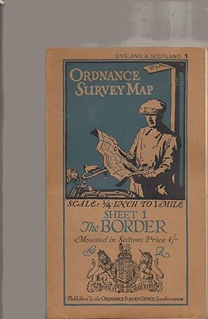
The Border. Ordnance Survey Map. Sheet 1. Scale 1/4 Inch to 1 Mile. Mounted in Sections.
Lingua: Inglese
Editore: Ordnance Survey Office, Southampton, UK, 1925
Da: SAVERY BOOKS, Brighton, East Sussex, Regno Unito
Valutazione del venditore 5 su 5 stelle
Mappa
EUR 18,74
Spedizione EUR 40,10
Spedito da Regno Unito a U.S.A.Quantit�: 1 disponibili
Aggiungi al carrelloCard Covers. Condizione: Very Good Plus. 17.5x9.5cm folded. Map is bright & clean & not damaged. Neatly folded. Dispatched ROYAL MAIL FIRST CLASS with TRACKING next working day or sooner securely boxed in cardboard. ref H9988.
-
Ordnance Survey Quarter Inch Map of The Border Region Sheet 1, Fourth Edition War Revision 1940
Lingua: Inglese
Editore: Ordnance Survey, 1943
Da: Morning Mist Books and Maps, Cirencester, Regno Unito
Valutazione del venditore 5 su 5 stelle
Mappa
EUR 11,80
Spedizione EUR 45,83
Spedito da Regno Unito a U.S.A.Quantit�: 1 disponibili
Aggiungi al carrelloNo Binding. Condizione: Very Good. Military edition with related gridlines overprinted but based on the pre-war fourth edition. Revised to 1939. Map mounted in sections on linen with Stanford covers and label. No holes or tears, a bright copy. Includes aerodromes, landing sites etc. Print code: 30,000/8/43 G.S., G.S. No. 3957. Further details available on request. (q99).
-
Ordnance Survey of Great Britain (Aeronautical map) The Border Sheet 1. 1/4 to 1 Mile Sheet.
Editore: Ordnance Survey
Da: Scrivener's Books and Bookbinding, Derbyshire, Regno Unito
Valutazione del venditore 4 su 5 stelle

EUR 35,40
Spedizione EUR 40,10
Spedito da Regno Unito a U.S.A.Quantit�: 1 disponibili
Aggiungi al carrelloSoft cover. Condizione: Good. Left hand edge of Map (strip starting with 'O' of Ordance Survey is missing) and the bottom edge & bottom right hand corner have all been trimmed away, leaving 12 panels of map. Presumably not required by the crew. Map clearly been used but colours are bright.

