
Importo totale (1 articolo articoli):
Destinazione ordine:

coltons new map missouri compiled (4 risultati)
Feedback
Vai alla pagina principale dei risultati di ricerca
Filtri di ricerca
Tipo di articolo
- Tutti i tipi di prodotto
- Libri (3)
- Riviste e Giornali (Nessun altro risultato corrispondente a questo perfezionamento)
- Fumetti (Nessun altro risultato corrispondente a questo perfezionamento)
- Spartiti (Nessun altro risultato corrispondente a questo perfezionamento)
- Arte, Stampe e Poster (Nessun altro risultato corrispondente a questo perfezionamento)
- Fotografie (Nessun altro risultato corrispondente a questo perfezionamento)
- Mappe (1)
- Manoscritti e Collezionismo cartaceo (Nessun altro risultato corrispondente a questo perfezionamento)
Condizioni Maggiori informazioni
- Nuovo (Nessun altro risultato corrispondente a questo perfezionamento)
- Come nuovo, Ottimo o Quasi ottimo (Nessun altro risultato corrispondente a questo perfezionamento)
- Molto buono o Buono (1)
- Discreto o Mediocre (Nessun altro risultato corrispondente a questo perfezionamento)
- Come descritto (3)
Legatura
- Tutte
- Rilegato (3)
- Brossura (Nessun altro risultato corrispondente a questo perfezionamento)
Ulteriori caratteristiche
- Prima ed. (1)
- Copia autograf. (Nessun altro risultato corrispondente a questo perfezionamento)
- Sovracoperta (Nessun altro risultato corrispondente a questo perfezionamento)
- Con foto (3)
- Non Print on Demand (4)
Lingua (1)
Prezzo
- Qualsiasi prezzo
- Inferiore a EUR 20 (Nessun altro risultato corrispondente a questo perfezionamento)
- EUR 20 a EUR 45 (Nessun altro risultato corrispondente a questo perfezionamento)
- Superiore a EUR 45
Spedizione gratuita
- Spedizione gratuita in U.S.A. (Nessun altro risultato corrispondente a questo perfezionamento)
Paese del venditore
Valutazione venditore
-
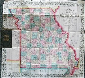
Colton's new Map of Missouri, Compiled from the U. S. Surveys and other Authentic Sources
Editore: New York, New York, 1869
Da: High Ridge Books, Inc. - ABAA, South Deerfield, MA, U.S.A.
Membro dell'associazione: ABAA ESA ILAB SNEAB
Valutazione del venditore 5 su 5 stelle

EUR 877,81
Convertire valutaEUR 7,24 per la spedizione in U.S.A.Quantit�: 1 disponibili
Aggiungi al carrelloOriginal cloth, fine condition. Full hand color by county. There is a contemporary pastedown slip at the top right of the map for H. T. Crane's "Central Book Store" in Maryville, Missouri.
-
Colton's New Map of Missouri Compiled from the U.S. Surveys and Other Authentic Sources
Editore: J H Colton, New York, 1852
Da: Old New York Book Shop, ABAA, Atlanta, GA, U.S.A.
Membro dell'associazione: ABAA ILAB
Valutazione del venditore 5 su 5 stelle
Prima edizione
EUR 307,23
Convertire valutaEUR 4,05 per la spedizione in U.S.A.Quantit�: 1 disponibili
Aggiungi al carrelloHardcover. Condizione: Very Good. First Edition. Doedecimo under 6" - 7". Hand colored map of Missouri measuring 28 3/4" x 24 3/4" hand colored in green, red, yellow, blue and pink. Split at some folds and at some corners. Folded into 12mo, and laid into a gilt stamped brown cloth case.
-

Colton's New Sectional Map of the State of Missouri. Compiled from the United States surveys & other authentic sources, exhibiting the sections, fractional sections, counties, cities, towns, villages, post offices, rail roads & other internal improvements
Editore: J.H. Colton, New York, 1862
Da: Bartleby's Books, ABAA, Chevy Chase, MD, U.S.A.
Membro dell'associazione: ABAA ESA ILAB IOBA
Valutazione del venditore 5 su 5 stelle
EUR 2.194,52
Convertire valutaEUR 6,82 per la spedizione in U.S.A.Quantit�: 1 disponibili
Aggiungi al carrelloEngraved broadside map, 37 x 41 1/2 inches, the counties hand-colored in light shades of blue, green, yellow, and pink, with a darker pink outlining state borders, all enclosed within a wide ornamental border. Cover title: "Colton's Sectional Map of Missouri." Cf. Phillips, p. 443 for the 1861 issue. Apparently not in the Rumsey online collection. OCLC locates one copy of this 1862 issue (Wisconsin-Milwaukee). Several old discreet institutional markings, map backed with archival paper, several small holes at corner folds, but very good otherwise. Folded into 12mo gilt-stamped black cloth boards (rebacked). (#3732).
-
Colton's New Sectional Map of the State of Missouri. Compiled from United States Surveys and other Authentic Sources.
Data di pubblicazione: 1861
Da: Geographicus Rare Antique Maps, Brooklyn, NY, U.S.A.
Membro dell'associazione: ABAA ESA ILAB
Valutazione del venditore 4 su 5 stelle

Mappa
EUR 1.179,77
Convertire valutaEUR 14,49 per la spedizione in U.S.A.Quantit�: 1 disponibili
Aggiungi al carrelloAverage. Mounted on fresh linen. Varnished. Dampstaining. Cracking. Wear along original fold lines. Some small areas reinstated or infilled. Size 36.5 x 42.5 Inches. This is an 1861 J. H. Colton map of Missouri at the beginning of the American Civil War (1861 - 1865). The map captures Missouri during a period when it was a violent microcosm of the greater abolition/pro-slavery divide. Although officially a slave state, Missouri harbored a large population of absolutists on both sides of the debate - and more from each side flooded in from 1850 on - turning it into a hotbed of violence and unrest that did not relent until long after the Civil War. A Closer Look Missouri appears divided into counties, with the Public Land Survey System grid superimposed. Cities and towns are labeled, with St. Joseph, St. Louis, Kansas City, and Palmyra prominent. Roads and railroads (including the Hannibal and St. Joseph Railroad, the North Missouri Railroad, and the Cairo and Fulton Railroad) snake through the state. The American Civil War in Missouri The American Civil War officially began on April 12, 1861, when Confederate forces fired on Fort Sumter in Charleston, South Carolina. However, the history of conflict in Missouri began decades earlier. Tensions in Missouri began in 1820 following the Missouri Compromise when Missouri was allowed to join the Union as a slave state and Maine as a free state. As part of the compromise, Congress declared that slavery would be illegal north of 36° 30' latitude. This brought southern slaveholders to Missouri, but its proximity to free states made Missouri an important part of the Underground Railroad. A little over thirty years later, as part of the Kansas-Nebraska Act, Congress decreed that the issue of slavery would be decided by a vote in the Kansas and Nebraska territories. This led to a flood of pro-slavery Missourians (known as 'Border Ruffians') into Kansas as well as anti-slavery 'Free-Staters' from northern states. Inevitably, violence erupted between these two factions in what has become known as 'Bleeding Kansas.' The two sides exchanged atrocities, with pro-slavery forces sacking Lawrence and abolitionist John Brown leading the Pottawatomie massacre. Finally, during the 1860 - 1861 secession crises, Missouri declared that it would remain 'militarily neutral,' not declaring allegiance to either the Union or the Confederacy and fighting any incursion into the state from either side. However, Missouri's newly elected governor, Claiborne Fox Jackson, was an ardent supporter of the Confederacy and worked behind the scenes to advocate for Missouri's secession. A potential flashpoint in Missouri was the St. Louis Arsenal (the greatest Union asset in the state), which held over 39,000 small arms. Unionists believed Jackson wanted to use the Missouri State Guard to capture the Arsenal and send the arms south to the Confederacy. President Lincoln sent reinforcements to guard the Arsenal, which eventually led to Union forces attacking the Missouri State Guard after learning that the Guard had received Confederate artillery, presuming (rightly?) that the artillery would be used to attack the Arsenal. Both sides attempted to sign a truce, but it did not last. By June 1861, the pro-Confederate elements of the government fled Jefferson City and created a government-in-exile in Neosho, Missouri, where it seceded. (In reality, this action meant almost nothing since the pro-Confederate government did not control any of Missouri.) After the governor's office was officially declared vacant, a pro-Union government took power, aligned with the Union, and tens of thousands of Missourians eventually served in the Union Army. In Missouri, armed field and guerilla conflict persisted throughout the war. The guerrilla aspects of the war in Missouri lasted well into the 1880s, even if the continued violence was not seen as directly related to the war. The James-Younger Gang, led by Jesse James, was one of the groups that continued fighting long after the war. Publication History and Census This map was created and published by J. H. Colton in 1861. The present 1862 edition is well represented in institutional collections. Colton first published his Sectional Map of Missouri in 1860 and his sons G. W. and C. B. Colton published editions of this map through the late 1870s. References: OCLC 243700613, 33252811.


