Importo totale (1 articolo articoli):
Destinazione ordine:

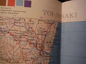
contour toi misaki di army map service (1 risultati)
Vai alla pagina principale dei risultati di ricerca
Filtri di ricerca
Tipo di articolo
- Tutti i tipi di prodotto
- Libri (Nessun altro risultato corrispondente a questo perfezionamento)
- Riviste e Giornali (Nessun altro risultato corrispondente a questo perfezionamento)
- Fumetti (Nessun altro risultato corrispondente a questo perfezionamento)
- Spartiti (Nessun altro risultato corrispondente a questo perfezionamento)
- Arte, Stampe e Poster (Nessun altro risultato corrispondente a questo perfezionamento)
- Fotografie (Nessun altro risultato corrispondente a questo perfezionamento)
- Mappe (1)
- Manoscritti e Collezionismo cartaceo (Nessun altro risultato corrispondente a questo perfezionamento)
Condizioni Maggiori informazioni
- Nuovo (Nessun altro risultato corrispondente a questo perfezionamento)
- Come nuovo, Ottimo o Quasi ottimo (1)
- Molto buono o Buono (Nessun altro risultato corrispondente a questo perfezionamento)
- Discreto o Mediocre (Nessun altro risultato corrispondente a questo perfezionamento)
- Come descritto (Nessun altro risultato corrispondente a questo perfezionamento)
Legatura
- Tutte
- Rilegato (Nessun altro risultato corrispondente a questo perfezionamento)
- Brossura (Nessun altro risultato corrispondente a questo perfezionamento)
Ulteriori caratteristiche
- Prima ed. (Nessun altro risultato corrispondente a questo perfezionamento)
- Copia autograf. (Nessun altro risultato corrispondente a questo perfezionamento)
- Sovracoperta (Nessun altro risultato corrispondente a questo perfezionamento)
- Con foto (1)
- Non Print on Demand (1)
Lingua (1)
Prezzo
- Qualsiasi prezzo
- Inferiore a EUR 20
- EUR 20 a EUR 45 (Nessun altro risultato corrispondente a questo perfezionamento)
- Superiore a EUR 45 (Nessun altro risultato corrispondente a questo perfezionamento)
Spedizione gratuita
- Spedizione gratuita in U.S.A. (Nessun altro risultato corrispondente a questo perfezionamento)
Paese del venditore
Valutazione venditore
-
Army Map Service Contour Map of Toi-Misaki, Japan (1944)
Editore: Army Map Service, 1944
Lingua: Inglese
Da: Imperial Books and Collectibles, Wauwatosa, WI, U.S.A.
Valutazione del venditore 5 su 5 stelle

Mappa
Map. Condizione: Fine. Original WW II era folded color contour Map of Toi-Misaki, Japan by the U. S. Army Map Service in 1944 (Second Edition). Single sided. Edges smooth no chips or tears. Clean and unmarked. Folded into four sections. Map dimensions 22.25" H x 20" W including borders. Scale 1:250,000 Contour intervals - 100 meters. Polyconic Projection. Highly detailed. Fine condition. Numerous WW II era maps of Japan listed and available.