Importo totale (1 articolo articoli):
Destinazione ordine:

daily mail milestone motor map (3 risultati)
Feedback
Vai alla pagina principale dei risultati di ricerca
Filtri di ricerca
Tipo di articolo
- Tutti i tipi di prodotto
- Libri (2)
- Riviste e Giornali (Nessun altro risultato corrispondente a questo perfezionamento)
- Fumetti (Nessun altro risultato corrispondente a questo perfezionamento)
- Spartiti (Nessun altro risultato corrispondente a questo perfezionamento)
- Arte, Stampe e Poster (Nessun altro risultato corrispondente a questo perfezionamento)
- Fotografie (Nessun altro risultato corrispondente a questo perfezionamento)
- Mappe (1)
- Manoscritti e Collezionismo cartaceo (Nessun altro risultato corrispondente a questo perfezionamento)
Condizioni Maggiori informazioni
- Nuovo (Nessun altro risultato corrispondente a questo perfezionamento)
- Come nuovo, Ottimo o Quasi ottimo (Nessun altro risultato corrispondente a questo perfezionamento)
- Molto buono o Buono (2)
- Discreto o Mediocre (Nessun altro risultato corrispondente a questo perfezionamento)
- Come descritto (1)
Legatura
- Tutte
- Rilegato (1)
- Brossura (Nessun altro risultato corrispondente a questo perfezionamento)
Ulteriori caratteristiche
- Prima ed. (2)
- Copia autograf. (Nessun altro risultato corrispondente a questo perfezionamento)
- Sovracoperta (Nessun altro risultato corrispondente a questo perfezionamento)
- Con foto (3)
- Non Print on Demand (3)
Lingua (2)
Prezzo
- Qualsiasi prezzo
- Inferiore a EUR 20 (Nessun altro risultato corrispondente a questo perfezionamento)
- EUR 20 a EUR 40
- Superiore a EUR 40
Spedizione gratuita
- Spedizione gratuita in U.S.A. (Nessun altro risultato corrispondente a questo perfezionamento)
Paese del venditore
Valutazione venditore
-

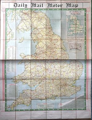
Daily Mail Milestone Motor Map: England (North Section and South Section together in slipcase)
Editore: George Philip & Son, 1920
Lingua: Inglese
Da: Shelley and Son Books (IOBA), Hendersonville, NC, U.S.A.
Membro dell'associazione: IOBA
Valutazione del venditore 5 su 5 stelle

EUR 30,55
Convertire valutaEUR 5,51 per la spedizione in U.S.A.Quantit�: 1 disponibili
Aggiungi al carrelloCondizione: Very Good. Map of England divided into two parts, a North Section and a South Section. Both maps contain 18 foldout panels on the original brown cloth backing. The actual date of publication is unknown, but these maps were produced in the 1920's. Slipcase reads "With Index" which is referring to the various tables included on the maps. Maps and slipcase in very good condition. Slipcase shows some wear at corners, and is mildly rubbed. More photos available upon request, full refund if not satisfied.
-
Daily Mail Milestone Motor Map
Editore: George Philip & Son Ltd., United Kingdom
Da: Certain Books, ABAA, Bolivia, NC, U.S.A.
Membro dell'associazione: ABAA ESA ILAB
Valutazione del venditore 5 su 5 stelle
Prima edizione
EUR 56,73
Convertire valutaEUR 8,47 per la spedizione in U.S.A.Quantit�: 1 disponibili
Aggiungi al carrelloSlipcase. Condizione: Very Good. Map. In two linen-backed sections; the North and South British Isles, lithographed in colors. Undated and circa 1930. Approx. 31" x 47"; some edge, tips wear to slipcase; map still brightly colored; in very good condition.
-
Daily Mail Milestone Motor Map: England: North Section and South Section together in slipcase.
Editore: The Daily Mail, George Philip & Son, undated [c.1920s]., London:, 1920
Da: Chapel Books, Westleton, SFK, Regno Unito
Valutazione del venditore 1 su 5 stelle

Mappa Prima edizione
EUR 35,39
Convertire valutaEUR 22,90 per la spedizione da Regno Unito a U.S.A.Quantit�: 1 disponibili
Aggiungi al carrelloMap. Condizione: Near Fine in worn slipcase. First or early edition. Both maps consist of 18 foldout panels on the original backing of brown cloth. Scale 1:500,000, 8 miles to 1 inch. Each map is 10.5x8ins folded, or c.31.5x48ins opened. Combined, they form a map 5' x 4': handy for the motorist with a flat-bed trailer on which to lay them out. Bright and clean, with no tears. Slipcase adequate but showing some wear and with a split at the bottom edge. 'With Index' is printed on the slipcase, but the only Index here is that of Motor Marks printed on the maps, as are the Perpetual Lighting-Up Table and a Table of Distances.