Importo totale (1 articolo articoli):
Destinazione ordine:

description litalie ancienne gaule cisalpine (2 risultati)
Feedback
Vai alla pagina principale dei risultati di ricerca
Filtri di ricerca
Tipo di articolo
- Tutti i tipi di prodotto
- Libri (1)
- Riviste e Giornali (Nessun altro risultato corrispondente a questo perfezionamento)
- Fumetti (Nessun altro risultato corrispondente a questo perfezionamento)
- Spartiti (Nessun altro risultato corrispondente a questo perfezionamento)
- Arte, Stampe e Poster (Nessun altro risultato corrispondente a questo perfezionamento)
- Fotografie (Nessun altro risultato corrispondente a questo perfezionamento)
- Mappe (1)
- Manoscritti e Collezionismo cartaceo (Nessun altro risultato corrispondente a questo perfezionamento)
Condizioni Maggiori informazioni
- Nuovo (Nessun altro risultato corrispondente a questo perfezionamento)
- Come nuovo, Ottimo o Quasi ottimo (1)
- Molto buono o Buono (Nessun altro risultato corrispondente a questo perfezionamento)
- Discreto o Mediocre (Nessun altro risultato corrispondente a questo perfezionamento)
- Come descritto (1)
Legatura
- Tutte
- Rilegato (Nessun altro risultato corrispondente a questo perfezionamento)
- Brossura (Nessun altro risultato corrispondente a questo perfezionamento)
Ulteriori caratteristiche
- Prima ed. (Nessun altro risultato corrispondente a questo perfezionamento)
- Copia autograf. (Nessun altro risultato corrispondente a questo perfezionamento)
- Sovracoperta (Nessun altro risultato corrispondente a questo perfezionamento)
- Con foto (2)
- Non Print on Demand (2)
Lingua (2)
Prezzo
- Qualsiasi prezzo
- Inferiore a EUR 20 (Nessun altro risultato corrispondente a questo perfezionamento)
- EUR 20 a EUR 45 (Nessun altro risultato corrispondente a questo perfezionamento)
- Superiore a EUR 45
Spedizione gratuita
- Spedizione gratuita in U.S.A. (Nessun altro risultato corrispondente a questo perfezionamento)
Paese del venditore
Valutazione venditore
-
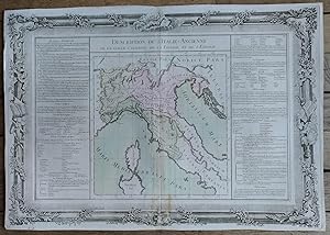
Description de l'ITALIE ancienne, de la GAULE CISALPINE, de la LIGURIE, et de l'ETRURIE
Editore: Desnos, PARIS, 1761
Lingua: Francese
Mappa
EUR 60,00
Convertire valutaEUR 28,70 per la spedizione da Francia a U.S.A.Quantit�: 1 disponibili
Aggiungi al carrelloPas de couverture. Condizione: Tr�s bon. Description de l'ITALIE ancienne, de la GAULE CISALPINE, de la LIGURIE, et de l'ETRURIE Grand document grav� (39 cm x 55.5 cm) sur papier verg� filigran�, issu de l'Atlas BUY de MORNAS, atlas m�thodique et �l�mentaire de G�ographie, Desnos, Paris, 1761 Bon �tat d'usage (carte aux contours coloris�s -pliure centrale verticale).
-

Description de L'Italie-Ancienne de la Gaule-Cisalpine, de la Ligurie, et de L'Etrurie.
Editore: Artist: Desnos Louis Charles ( - 1805 ) Paris; issued in: Paris; - Louis-Charles Desnos (1725 - 1805) was both a globe maker and publisher of maps In the former capacity he was appointed globe maker to the King of Denmark but spent most of his life working in Paris Louis Charles Desnos and Claude Buy de Mornas worked together in the same establishments and issued together "La Manniere de Reconnoitre les Principales Etoiles dans le Ciel" (The Manner of Recognizing the Principal Stars in the Sky) in 1761; ca: 1700, 1725
Da: Antique Sommer& Sapunaru KG, M�nchen, Germania
Membro dell'associazione: ILAB VDA
Valutazione del venditore 5 su 5 stelle

EUR 390,00
Convertire valutaEUR 45,00 per la spedizione da Germania a U.S.A.Quantit�: 1 disponibili
Aggiungi al carrelloTechnic: Copper print, colorit: coloredcondition: Perfect condition, size (in cm): 36,5 x 53 cm cm; - Map shows northern Italy up to Campania with Corsica and partly Sardinia with floral border. Map describes left and right of Old Italy, of Gaul-Cisalpina, Liguria and Etruria.