Importo totale (1 articolo articoli):
Destinazione ordine:

java map sumatra borneo bali di schenk valk (1 risultati)
Feedback
Vai alla pagina principale dei risultati di ricerca
Filtri di ricerca
Tipo di articolo
- Tutti i tipi di prodotto
- Libri (1)
- Riviste e Giornali (Nessun altro risultato corrispondente a questo perfezionamento)
- Fumetti (Nessun altro risultato corrispondente a questo perfezionamento)
- Spartiti (Nessun altro risultato corrispondente a questo perfezionamento)
- Arte, Stampe e Poster (Nessun altro risultato corrispondente a questo perfezionamento)
- Fotografie (Nessun altro risultato corrispondente a questo perfezionamento)
- Mappe (Nessun altro risultato corrispondente a questo perfezionamento)
- Manoscritti e Collezionismo cartaceo (Nessun altro risultato corrispondente a questo perfezionamento)
Condizioni
- Tutte
- Nuovi (Nessun altro risultato corrispondente a questo perfezionamento)
- Antichi o usati (1)
Legatura
- Tutte
- Rilegato (Nessun altro risultato corrispondente a questo perfezionamento)
- Brossura (Nessun altro risultato corrispondente a questo perfezionamento)
Ulteriori caratteristiche
- Prima ed. (Nessun altro risultato corrispondente a questo perfezionamento)
- Copia autograf. (Nessun altro risultato corrispondente a questo perfezionamento)
- Sovracoperta (Nessun altro risultato corrispondente a questo perfezionamento)
- Con foto (1)
- Non Print on Demand (1)
Lingua (1)
Prezzo
- Qualsiasi prezzo
- Inferiore a EUR 20 (Nessun altro risultato corrispondente a questo perfezionamento)
- EUR 20 a EUR 45 (Nessun altro risultato corrispondente a questo perfezionamento)
- Superiore a EUR 45
Spedizione gratuita
- Spedizione gratuita in Italia (Nessun altro risultato corrispondente a questo perfezionamento)
Paese del venditore
Valutazione venditore
-
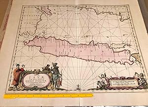
Java map with some of Sumatra, Borneo, Bali ca. 1700
Editore: P. Schenk & G. Valk, Amsterdam, 1700
Da: Carydale Books, Rhinebeck, NY, U.S.A.
Valutazione del venditore 4 su 5 stelle

EUR 176,23
Convertire valutaEUR 36,21 per la spedizione da U.S.A. a ItaliaQuantit�: 1 disponibili
Aggiungi al carrelloDisbound. Condizione: Good. No Jacket. map area ca. 16.5"x 20.1" on paper sheet ca. 20" x 24", paper age darkened - early hand colored map of Java with parts of other island and penninsulas shown. Not dated but ca. 1700. It has clear evidence of a fold down the middle. Colors a bit dull, but present. A small symbol of a fort is shown at Batavia- the Dutch Capital. Cracata- presumably Krakatoa- is indicated as an island in the Sunda Straits west of Java. Overall, a good copy. Due to size, this may be rolled and shipped in a tube - especially for international shipping.