

Importo totale (1 articolo articoli):
Destinazione ordine:

libya tourist map (9 risultati)
Vai alla pagina principale dei risultati di ricerca
Filtri di ricerca
Tipo di articolo
- Tutti i tipi di prodotto
- Libri (7)
- Riviste e Giornali (Nessun altro risultato corrispondente a questo perfezionamento)
- Fumetti (Nessun altro risultato corrispondente a questo perfezionamento)
- Spartiti (Nessun altro risultato corrispondente a questo perfezionamento)
- Arte, Stampe e Poster (Nessun altro risultato corrispondente a questo perfezionamento)
- Fotografie (Nessun altro risultato corrispondente a questo perfezionamento)
- Mappe (2)
- Manoscritti e Collezionismo cartaceo (Nessun altro risultato corrispondente a questo perfezionamento)
Condizioni Maggiori informazioni
- Nuovo (7)
- Come nuovo, Ottimo o Quasi ottimo (1)
- Molto buono o Buono (Nessun altro risultato corrispondente a questo perfezionamento)
- Discreto o Mediocre (Nessun altro risultato corrispondente a questo perfezionamento)
- Come descritto (1)
Legatura
- Tutte
- Rilegato (Nessun altro risultato corrispondente a questo perfezionamento)
- Brossura (Nessun altro risultato corrispondente a questo perfezionamento)
Ulteriori caratteristiche
- Prima ed. (Nessun altro risultato corrispondente a questo perfezionamento)
- Copia autograf. (Nessun altro risultato corrispondente a questo perfezionamento)
- Sovracoperta (Nessun altro risultato corrispondente a questo perfezionamento)
- Con foto (4)
- Non Print on Demand (9)
Lingua (2)
Spedizione gratuita
Paese del venditore
Valutazione venditore
-

Jebel Acacus Libya Tourist Map and Guide (Folded)
Lingua: Inglese
Editore: West Col Productions, Reading, 2006
ISBN 10: 0906227933 ISBN 13: 9780906227930
Da: Grand Eagle Retail, Bensenville, IL, U.S.A.
Valutazione del venditore 5 su 5 stelle

Folded. Condizione: new. Folded. Offers tourist and trekking information in English and French. Shipping may be from multiple locations in the US or from the UK, depending on stock availability.
-
Jebel Acacus Libya Tourist Map and Guide
Da: PBShop.store US, Wood Dale, IL, U.S.A.
Valutazione del venditore 5 su 5 stelle
UNK. Condizione: New. New Book. Shipped from UK. Established seller since 2000.
-
Jebel Acacus Libya Tourist Map and Guide
Da: PBShop.store UK, Fairford, GLOS, Regno Unito
Valutazione del venditore 5 su 5 stelle
EUR 19,53
Spedizione EUR 3,81
Spedito da Regno Unito a U.S.A.Quantità: 15 disponibili
Aggiungi al carrelloUNK. Condizione: New. New Book. Shipped from UK. Established seller since 2000.
-
Jebel Acacus Libya Tourist Map and Guide
Da: THE SAINT BOOKSTORE, Southport, Regno Unito
Valutazione del venditore 5 su 5 stelle
EUR 19,54
Spedizione EUR 18,54
Spedito da Regno Unito a U.S.A.Quantità: Più di 20 disponibili
Aggiungi al carrelloSheet map, folded. Condizione: New. New copy - Usually dispatched within 4 working days.
-

Jebel Acacus Libya Tourist Map and Guide
Da: Rarewaves.com USA, London, LONDO, Regno Unito
Valutazione del venditore 5 su 5 stelle
EUR 39,80
Spedizione gratuita
Spedito da Regno Unito a U.S.A.Quantità: 1 disponibili
Aggiungi al carrelloMap. Condizione: New.
-
Jebel Acacus Libya Tourist Map and Guide (Folded)
Lingua: Inglese
Editore: West Col Productions, Reading, 2006
ISBN 10: 0906227933 ISBN 13: 9780906227930
Da: AussieBookSeller, Truganina, VIC, Australia
Valutazione del venditore 5 su 5 stelle
EUR 41,35
Spedizione EUR 31,88
Spedito da Australia a U.S.A.Quantità: 1 disponibili
Aggiungi al carrelloFolded. Condizione: new. Folded. Offers tourist and trekking information in English and French. Shipping may be from our Sydney, NSW warehouse or from our UK or US warehouse, depending on stock availability.
-

Jebel Acacus Libya Tourist Map and Guide
Da: Rarewaves.com UK, London, Regno Unito
Valutazione del venditore 5 su 5 stelle
EUR 36,60
Spedizione EUR 75,26
Spedito da Regno Unito a U.S.A.Quantità: 1 disponibili
Aggiungi al carrelloMap. Condizione: New.
-
![Immagine del venditore per - / [Libya Tourist Map Guide]. venduto da Geographicus Rare Antique Maps](https://pictures.abebooks.com/inventory/md/md32307605675.jpg)
- / [Libya Tourist Map Guide].
Data di pubblicazione: 1962
Da: Geographicus Rare Antique Maps, Brooklyn, NY, U.S.A.
Membro dell'associazione: ABAA ESA ILAB
Valutazione del venditore 3 su 5 stelle

Mappa
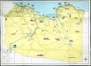
Very good. Some minor verso reinforcement along some old fold splits. Size 18 x 25.75 Inches. This is a c. 1962 tourist pictorial map of Libya produced by the country's Public Tourist Administration. It was produced in the wake of the discovery of vast oil reserves in the country, which rapidly transformed it from one of the poorest countries in the world to among the wealthiest post-colonial states. A Closer Look Libya is displayed with color-shading, giving a sense of terrain, with spots of green near the coast and around oases. Settlements of various sizes, roads of different types and qualities, oil fields, and other features are indicated according to the legend at bottom-left. Distances in kilometers between settlements are marked in red. Illustrations refer to the history, economy, recreational activities, and wildlife of different regions, including the country's impressive historical ruins, such as the Roman ruins at Sabratha (??????) and Leptis Magna (????), some of the best preserved in the Mediterranean, as well as the ancient Greek colony of Cyrene in the country's northeast. A Libyan Golden Age? Like other Italian colonies in Africa, Libya's transition out of colonization was fairly gradual. The area was invaded and occupied by the Allies by 1943, with the coastal provinces of Tripolitana and Cyrenaica administered by the British, and Fezzan, in the southwest and bordering Algeria, administered by France. In 1951, the Allied occupation ended, and a new independent kingdom was established under the leadership of Sayyid Idris, the Emir of Cyrenaica. The new government maintained relations with the Soviet Union and the emerging Arab nationalist movement, but was overall pro-Western, allowing British and American military bases and foreign companies, including Italian ones, on its soil. In June 1959, Libya's historical trajectory was radically altered when prospectors from Esso (now Exxon) discovered large oil reserves in Cyrenaica. In 1961, the largest oil field in Libya was discovered at the Sarir field. As the government retained 50 percent of the oil profits, it quickly became incredibly wealthy. But this fantastic new wealth was not evenly distributed, and the country's pronounced regionalism could not be overcome despite reforms meant to do so. By the late 1960s, both the U.S. and U.K. intelligence services expected a coup against the monarchy, and indeed a group of army officers led by Muammar Gaddafi did just that on September 1, 1969. Publication History and Census Although not indicated here, this map was prepared by the Public Tourist Administration of Libya (??????? ?????? ??????? ???????). It is undated, but the presence of oil fields and the United Arab Republic both indicate a date later than 1959 and most likely in the early 1960s. This map is not noted in the OCLC, but the David Rumsey Historical Map Collection holds an example. References: Rumsey 16385.000.
-
Libya Tourist Map
Data di pubblicazione: 1960
Da: Antikvariat Krenek, Prag, Repubblica Ceca
Membro dell'associazione: ILAB
Valutazione del venditore 5 su 5 stelle
Mappa
EUR 125,01
Spedizione EUR 14,50
Spedito da Repubblica Ceca a U.S.A.Quantità: 1 disponibili
Aggiungi al carrelloKein Einband. Condizione: Gut bis sehr gut. Libya - pictorial map. "Libya Tourist Map". Orig. lithograph in colour, ca. 1960. With title cartouche and many illustrations. 45,5:64,5 cm (18 x 25 1/2 inch.). Pictorial, originally folded, tourist map of Libya printed in the 1960s, during the country's economic boom after the discovery of oil reserves in 1959 and before the 1969 coup d'état. Shows major tourist attractions, main and secondary roads and gravel roads, distances between towns, oil fields and geographical names.

