Importo totale (1 articolo articoli):
Destinazione ordine:

map massachusetts proper compiled actual di carleton osgood (4 risultati)
Vai alla pagina principale dei risultati di ricerca
Filtri di ricerca
Tipo di articolo
- Tutti i tipi di prodotto
- Libri (2)
- Riviste e Giornali (Nessun altro risultato corrispondente a questo perfezionamento)
- Fumetti (Nessun altro risultato corrispondente a questo perfezionamento)
- Spartiti (Nessun altro risultato corrispondente a questo perfezionamento)
- Arte, Stampe e Poster (Nessun altro risultato corrispondente a questo perfezionamento)
- Fotografie (Nessun altro risultato corrispondente a questo perfezionamento)
- Mappe (2)
- Manoscritti e Collezionismo cartaceo (Nessun altro risultato corrispondente a questo perfezionamento)
Condizioni Maggiori informazioni
- Nuovo (Nessun altro risultato corrispondente a questo perfezionamento)
- Come nuovo, Ottimo o Quasi ottimo (Nessun altro risultato corrispondente a questo perfezionamento)
- Molto buono o Buono (Nessun altro risultato corrispondente a questo perfezionamento)
- Discreto o Mediocre (Nessun altro risultato corrispondente a questo perfezionamento)
- Come descritto (4)
Legatura
- Tutte
- Rilegato (1)
- Brossura (Nessun altro risultato corrispondente a questo perfezionamento)
Ulteriori caratteristiche
- Prima ed. (2)
- Copia autograf. (1)
- Sovracoperta (Nessun altro risultato corrispondente a questo perfezionamento)
- Con foto (3)
- Non Print on Demand (4)
Lingua (1)
Prezzo
- Qualsiasi prezzo
- Inferiore a EUR 20 (Nessun altro risultato corrispondente a questo perfezionamento)
- EUR 20 a EUR 45 (Nessun altro risultato corrispondente a questo perfezionamento)
- Superiore a EUR 45
Spedizione gratuita
Paese del venditore
Valutazione venditore
-
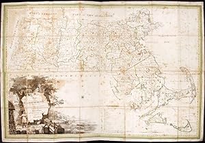
Map of Massachusetts proper compiled from Actual Surveys made by Order of the General Court, and under the inspection of agents of their appointment
Editore: B. & J. Loring, [Boston, 1801
Da: Donald A. Heald Rare Books (ABAA), New York, NY, U.S.A.
Membro dell'associazione: ABAA ILAB
Valutazione del venditore 5 su 5 stelle

Mappa Prima edizione Copia autografata
Copper-engraved map, with original outline colour, folded and mounted on linen. Publisher's paper label to verso, in good condition apart from some slight browning. Modern cloth chemise, within a morocco-backed cloth slipcase. A very rare and highly important early map of Massachusetts. The revised and much improved first "official" edition of the most important early map of Massachusetts. In three key ways, this edition is a great improvement over Osgood Carleton's 1798 original which was rejected for official sanction by the government of the Commonwealth. Firstly, the coastline and coastal islands have been more correctly rendered, largely due to the incorporation of information from the charts of Joseph Des Barres. Secondly, roads and streams that had been left incomplete in the earlier map were extended. Thirdly, some of the clutter of the 1798 map, engraved by Carleton's partner, John Norman, was removed, and the map is more attractive and informative, with a cleaner and crisper appearance. The history of the creation and publication of Carleton's map is interesting. There was a movement to create a state-sponsored map of Massachusetts as early as 1791. In 1795, after a failed attempt by the Massachusetts Historical Society, Osgood Carleton and John Norman signed a contract with the Commonwealth to create a state map based on surveys submitted by every town, with the entire map to be endorsed as to its quality by the state government. The map was produced in 1798, but it failed to win approval by the General Court which criticized Norman's engraving. The government asked Norman to redraw the map, although he had already printed 400 copies and went about marketing it without the official seal of approval from the Massachusetts government. Carleton, however, began to recompile the map and the firm of Callendar and Hill was contracted to engrave it. The present version of the map was approved by the General Court in 1801, and 500 copies were ordered to be printed. The map was published by B. & J. Loring in Boston, and offered (along with a companion map of Maine, which was then a constituent part of Massachusetts) at four dollars for a set, seven dollars if mounted on cloth with rollers, and eight dollars folded into cases. This copy of the map retains the publisher's original paper label, which forcefully asserts that this 1801 version of the Carleton map of Massachusetts, approved by the General Court, is "the only accurate one ever published of this state." The map is drawn on a scale of four miles to the inch, and gives a clear delineation of the boundaries and coastline of Massachusetts, and of the borders of each town in the state. The distance of each town from Boston and from their respective county seat is given, and major roads and streams are shown. Public and private institutions, including academies, meetinghouses, courthouses, etc., are located, as are topographical features such as mountains, ponds, rivers and streams. The cartouche, smaller in size and more attractive than that in the 1798 version, is still quite large, taking up much of the lower left corner of the map. It shows an Indian standing beside trees on a shoreline, with boats in the distant waters, and casks, anchors, nets, and a globe in the foreground. Danforth, 'The First Official Maps of Maine and Massachusetts,' in Imago Mundi 35 (1983), pp. 37-57; Krieger & Cobb, Mapping Boston, p. 52; Phillips, A List of Maps of America, p. 400; Ristow, American Maps and Mapmakers, pp. 89-92.
-

Map of Massachusetts Proper Compiled from Actual Surveys Made by Order of the General Court, and Under the Inspection of Agents of Their Appolintment
Editore: Boston, Boston, 1801
Da: High Ridge Books, Inc. - ABAA, South Deerfield, MA, U.S.A.
Membro dell'associazione: ABAA ESA ILAB SNEAB
Valutazione del venditore 5 su 5 stelle
4 part map, restored. Modern linen backing. Extensive facsimile work at edges, particularly in the large cartouche at the lower left. An early crease runs vertically through Hampshire County and there is a 2 inch circular stain in the lower right border, just below Nantucket. While extensively restored, this is now a very presentable copy of and early, important map of Massachusetts by Carleton, one of the most prominent early American cartographers. The map was engraved by Joseph Callender and Samuel Hall. The vignette was drawn by G. Graham.
-

Map of Massachusetts Proper Compiled form Actual Surveys made by Order of the General Court, and under the inspection of Agents of their appointment, by Osgood Carleton.
Data di pubblicazione: 1801
Da: Geographicus Rare Antique Maps, Brooklyn, NY, U.S.A.
Membro dell'associazione: ABAA ESA ILAB
Valutazione del venditore 5 su 5 stelle
Mappa Prima edizione
Very good. Full professional restoration Dissected as issued and mounted on fresh linen. Size 32 x 47.5 Inches. Known as 'The Agent's Map', this is a fine example of the first official map of Massachusetts, published in 1801 by Osgood Carleton. The map emerged out of a long and complex struggle to produce a large-scale, accurate, and comprehensive state map - something increasingly important in the heady early days of independence following the American Revolutionary War (1775 - 1783). This expansive map covers all of Massachusetts in considerable detail, giving no attention whatsoever to the neighboring states. While generally ignoring topography, the map offers superb practical detail throughout, noting roads, county borders, schools, meeting houses, courts, milage from Boston, and more. The sole mountain illustrated is the Hoosack Range, near modern-day North Adams. A Long and Complicated History The Massachusetts legislature put out a call for a large-scale state map in 1792. In the subsequent months, the state received several proposals. Nearly 18 months later, in June of 1794, they accepted a proposal put forth by veteran cartographers Osgood Carleton and John Norman. Both Carleton and Norman were known to the Legislature. They traveled in educated circles and had already published an important nautical atlas of great benefit to Massachusetts seamen. They further liked Carleton's proposal that a regional map be produced by each town - at the town's expense - sparing the state the need for immediate cash outlay. Collecting the Surveys While the process of mandating that each town produce its own local survey, at its own expense, became the norm for state mapmaking, in 1794 it was revolutionary. Some towns had already produced detailed surveys, so had no problem submitting them, but most lacked the means and expertise to issue anything comprehensive. Provincetown, for example, submitted a 'plan' consisting of nothing more than an outline of the town with no interior detail. More than 90 other towns simply ignored the legislative mandate and submitted nothing at all. The legislature began assessing tax penalties on non-compliant towns, and all but 17 eventually produced surveys, although many were inaccurate and useless. Presenting the Finished Map Despite these many issues, Carleton and Normal completed the map roughly on schedule, presenting it to a committee established by the Massachusetts Legislature on June 29, 1798. The committee was unimpressed. The engraving, done by Norman, was hastily completed and sloppy, leading to numerous errors. Moreover, attempts to illustrate topography with mountain profiles resulted in a sloppy, cluttered map. The legislature demanded these issues be fixed, It is expected in the Mean time they correct all the Error in said maps, and take out the many accidental strokes in the Plate; and also that they make Margins of the Rivers, Ponds, and Sea Coasts neater, and that the whole Plate be better Polished ( Boston Gazette , Aug. 20, 1798, quoted in Ristow, W., American Maps and Mapmakers , p. 91.). The legislature further appointed the known geographical experts Jedidiah Morse, John Davis, and Samuel Webber as 'Agents of the Commonwealth' (Davis later withdrew) to verify the soon-to-be-revised map. The First Official Map of Massachusetts It took Carleton more than two years to revise the map to his satisfaction. In this time, new surveys arrived from the delinquent towns, and others were ordered or updated. Carleton split with Norman and hired two new engravers, Samuel Hill and Joseph Callender, both well known in Boston for quality work. He also reached out to the artist and line-and-stipple engraver George Graham to produce a striking new vignette cartouche. The final product incorporated the wealth of new information, but also removed all topography (except lakes and rivers), yielding a clean, easy-to-read map rich in detail. The new cartouche was also impressive, featuring rich pastures.
-

Map of Massachusetts Proper Compiled from Actual Surveys
Data di pubblicazione: 1801
Da: Arader Galleries - AraderNYC, New York, NY, U.S.A.
Valutazione del venditore 5 su 5 stelle
No Binding. Condizione: Please Contact Seller. With the end of the war arrived a new sense of American pride and confidence, and detailed mapping of the states and their cities came into great demand partly for administrative purposes. Osgood Carleton was at the forefront of this trend and with the assistance of the Massachusetts Historical Society, lobbied the Massachusetts State Legislature to pass a resolution in 1794 directing each town to prepare an accurate town map. This is the second map of Massachusetts by Carleton. His first was made in 1798, but when the Massachusetts Historical Society examined the engraved plates, they deemed his work to be unsatisfactory. Working from Carleton's design and the information he gathered, the map was re-engraved by Samuel Hill and Joseph Callender and published by the Commonwealth of Massachusetts in 1801. This map is now known as the first official map of Massachusetts. Engraving Engraved by Joseph Callender and Samuel HillVignette Drawn by G. GrahamThomas & Andrews: Boston, 1801 1801 Size: Unframed: 47 x 31.5". Book.