Importo totale (1 articolo articoli):
Destinazione ordine:

a r fremin (38 risultati)
Vai alla pagina principale dei risultati di ricerca
Filtri di ricerca
Tipo di articolo
- Tutti i tipi di prodotto
- Libri (30)
- Riviste e Giornali (Nessun altro risultato corrispondente a questo perfezionamento)
- Fumetti (Nessun altro risultato corrispondente a questo perfezionamento)
- Spartiti (Nessun altro risultato corrispondente a questo perfezionamento)
- Arte, Stampe e Poster (4)
- Fotografie (Nessun altro risultato corrispondente a questo perfezionamento)
- Mappe (4)
- Manoscritti e Collezionismo cartaceo (Nessun altro risultato corrispondente a questo perfezionamento)
Condizioni Maggiori informazioni
- Nuovo (Nessun altro risultato corrispondente a questo perfezionamento)
- Come nuovo, Ottimo o Quasi ottimo (5)
- Molto buono o Buono (11)
- Discreto o Mediocre (Nessun altro risultato corrispondente a questo perfezionamento)
- Come descritto (22)
Legatura
Ulteriori caratteristiche
- Prima ed. (2)
- Copia autograf. (Nessun altro risultato corrispondente a questo perfezionamento)
- Sovracoperta (Nessun altro risultato corrispondente a questo perfezionamento)
- Con foto (21)
- Non Print on Demand (38)
Lingua (3)
Spedizione gratuita
- Spedizione gratuita in U.S.A. (Nessun altro risultato corrispondente a questo perfezionamento)
Paese del venditore
Valutazione venditore
-
![Immagine del venditore per Carte du Partage de la Terre Aux Trois Fils de Noe et a Leurs Descendans [Map of the Parts of the Earth of Noah's Three Sons and Their Descendants] venduto da Pazzo Books](https://pictures.abebooks.com/inventory/md/md14380041440.jpg)
Carte du Partage de la Terre Aux Trois Fils de Noe et a Leurs Descendans [Map of the Parts of the Earth of Noah's Three Sons and Their Descendants]
Editore: Paris, 1844
Da: Pazzo Books, Boston, MA, U.S.A.
Membro dell'associazione: ABAA ILAB SNEAB
Valutazione del venditore 5 su 5 stelle

14" x 11", light foxing. Quantity Available: 1. Shipped Weight: Under 1 kilo. Category: Prints, maps, broadsides; Inventory No: 044671.
-
![Immagine del venditore per Plan et Distribution de la Terre de Chanaan [Map of the Land of Canaan] venduto da Pazzo Books](https://pictures.abebooks.com/inventory/md/md14380039388.jpg)
Plan et Distribution de la Terre de Chanaan [Map of the Land of Canaan]
Data di pubblicazione: 1844
Da: Pazzo Books, Boston, MA, U.S.A.
Membro dell'associazione: ABAA ILAB SNEAB
Valutazione del venditore 5 su 5 stelle
Condizione: Very Good Condition. 12 1/2" x 9" map, light foxing. Quantity Available: 1. Shipped Weight: Under 1 kilo. Category: Prints, maps, broadsides; Inventory No: 044669.
-

CARTE DU DEPARTEMENT DE LA SARTHE
Lingua: Francese
Data di pubblicazione: 1910
Da: Librairie Guimard, Nantes, Francia
Valutazione del venditore 4 su 5 stelle

EUR 23,00
Spedizione EUR 30,00
Spedito da Francia a U.S.A.Quantit�: 1 disponibili
Aggiungi al carrello1910 chemise cart. �d. in-12, d. rouge pass�, etiquette �d. coll�e / 1er pl., carte en coul., col. � gauche : l�gende des signes et � droite col. : statistique et renseignements divers, gaultier �d.,atlas des d�partements de la france - r�gion de l'ouest n � 70 - grav�e par dyonnet et b�nard, rectifi�e par grangez - fin 19� si�cle - 1 d�chirure sur la bande de titre entre la fin du mot d�partement et l'�cusson de la ville du mans.
-
CARTE DE LA SYRIE.
Editore: Paris, F�lix Locquin et Cie, 1839. Planche 380x270mm (carte 240x190mm) extraite de l'Atlas de la Sainte Bible. Grav� par BARRIERE fr�res., 1839
Da: LE SERPENT QUI PENSE, PRECHAC, Francia
Valutazione del venditore 4 su 5 stelle
EUR 20,00
Spedizione EUR 40,00
Spedito da Francia a U.S.A.Quantit�: 1 disponibili
Aggiungi al carrelloPetite et tr�s l�g�re mouillure marginale (0,3cm), sinon tr�s bon �tat.
-
CARTE DU PARTAGE DE LA TERRE AUX TROIS FILS DE NOE et � leurs descendans.
Editore: Paris, F�lix Locquin et Cie, 1839. Planche 270x380mm (carte 240x325mm) extraite de l'Atlas de la Sainte Bible. Grav� par BARRIERE fr�res., 1839
Da: LE SERPENT QUI PENSE, PRECHAC, Francia
Valutazione del venditore 4 su 5 stelle
EUR 20,00
Spedizione EUR 40,00
Spedito da Francia a U.S.A.Quantit�: 1 disponibili
Aggiungi al carrelloPetite mouillure marginale (0,5cm), sinon tr�s bon �tat.
-
CARTE DU VOYAGE DES ISRAELITES depuis leur sortie d'Egypte jusqu'au passage du Jourdain, d'apr�s le P. Sicard et d'autres voyageurs plus modernes.
Editore: Paris, F�lix Locquin et Cie, 1839. Planche 270x380mm (carte hors marges 180x230mm) extraite de l'Atlas de la Sainte Bible. Grav� par BARRIERE fr�res., 1839
Da: LE SERPENT QUI PENSE, PRECHAC, Francia
Valutazione del venditore 4 su 5 stelle
EUR 20,00
Spedizione EUR 40,00
Spedito da Francia a U.S.A.Quantit�: 1 disponibili
Aggiungi al carrelloPetite et tr�s l�g�re mouillure marginale (0,5cm), sinon tr�s bon �tat.
-
CARTE DE LA MONARCHIE DES HEBREUX SOUS SALOMON ou le Royaume d'Isra�l divis� en douze gouvernements.
Editore: Paris, F�lix Locquin et Cie, 1839. Planche 380x270mm (carte 340x250mm) extraite de l'Atlas de la Sainte Bible. Grav� par BARRIERE fr�res., 1839
Da: LE SERPENT QUI PENSE, PRECHAC, Francia
Valutazione del venditore 4 su 5 stelle
EUR 20,00
Spedizione EUR 40,00
Spedito da Francia a U.S.A.Quantit�: 1 disponibili
Aggiungi al carrelloTRES BON ETAT.
-
PLAN ET DISTRIBUTION DE LA TERRE DE CHANAAN Suivant la vision d'Ez�chiel.
Editore: Paris, F�lix Locquin et Cie, 1839. Planche 380x270mm (carte 220x175mm) extraite de l'Atlas de la Sainte Bible. Grav� par BARRIERE fr�res., 1839
Da: LE SERPENT QUI PENSE, PRECHAC, Francia
Valutazione del venditore 4 su 5 stelle
EUR 20,00
Spedizione EUR 40,00
Spedito da Francia a U.S.A.Quantit�: 1 disponibili
Aggiungi al carrelloPetite et l�g�re mouillure marginale, sinon tr�s bon �tat.
-
CARTE DU MIDI DE LA JUDEE, ou TERRE SAINTE comprenant les Tribus d'ephra�m, de Gad, de Dan, de ruben, de Sim�on, de Benjamin et de Juda.
Editore: Paris, F�lix Locquin et Cie, 1839. Planche 270x380mm (carte hors marges 235x350mm) extraite de l'Atlas de la Sainte Bible. Grav� par BARRIERE fr�res., 1839
Da: LE SERPENT QUI PENSE, PRECHAC, Francia
Valutazione del venditore 4 su 5 stelle
EUR 20,00
Spedizione EUR 40,00
Spedito da Francia a U.S.A.Quantit�: 1 disponibili
Aggiungi al carrelloPetite et tr�s l�g�re mouillure marginale (0,3cm), sinon tr�s bon �tat.
-
CARTE DU PARADIS TERRESTRE adapt�e aux deux syst�mes de D. Calmet et de Huet.
Editore: Paris, F�lix Locquin et Cie, 1839. Planche 380x270mm (carte 220x160mm) extraite de l'Atlas de la Sainte Bible. Grav� par BARRIERE fr�res., 1839
Da: LE SERPENT QUI PENSE, PRECHAC, Francia
Valutazione del venditore 4 su 5 stelle
EUR 20,00
Spedizione EUR 40,00
Spedito da Francia a U.S.A.Quantit�: 1 disponibili
Aggiungi al carrelloQuelques p�les rousseurs, petite mouillure marginale, sinon bon �tat.
-
CARTE DE LA TERRE DE CHANAAN OU TERRE PROMISE � Abraham et sa post�rit�.
Editore: Paris, F�lix Locquin et Cie, 1839. Planche 380x270mm (carte 270x160mm) extraite de l'Atlas de la Sainte Bible. Grav� par BARRIERE fr�res., 1839
Da: LE SERPENT QUI PENSE, PRECHAC, Francia
Valutazione del venditore 4 su 5 stelle
EUR 20,00
Spedizione EUR 40,00
Spedito da Francia a U.S.A.Quantit�: 1 disponibili
Aggiungi al carrelloPetite et tr�s l�g�re mouillure marginale (0,5cm), sinon tr�s bon �tat (petite tache au verso de la gravure transparaissant l�g�rement au recto (marge).
-
CARTE DE L'EMPIRE DES PERSES pour servir � l'intelligence des livres d'Esdras, de N�h�mias, de Tobie, de Judith, d'Esther, de Job et des Proph�tes.
Editore: Paris, F�lix Locquin et Cie, 1839. Planche 380x270mm (carte 220x320mm) extraite de l'Atlas de la Sainte Bible. Grav� par BARRIERE fr�res., 1839
Da: LE SERPENT QUI PENSE, PRECHAC, Francia
Valutazione del venditore 4 su 5 stelle
EUR 20,00
Spedizione EUR 40,00
Spedito da Francia a U.S.A.Quantit�: 1 disponibili
Aggiungi al carrelloPetite et l�g�re mouillure marginale, sinon tr�s bon �tat.
-
CARTE DES VOYAGES DES APOTRES ST PIERRE ET ST PAUL.
Editore: Paris, F�lix Locquin et Cie, 1839. Planche 380x270mm (carte 190x330mm) extraite de l'Atlas de la Sainte Bible. Grav� par BARRIERE fr�res., 1839
Da: LE SERPENT QUI PENSE, PRECHAC, Francia
Valutazione del venditore 4 su 5 stelle
EUR 20,00
Spedizione EUR 40,00
Spedito da Francia a U.S.A.Quantit�: 1 disponibili
Aggiungi al carrelloPetite et l�g�re mouillure marginale, sinon tr�s bon �tat.
-
CARTE DU NORD DE LA JUDEE, ou TERRE SAINTE comprenant les Tribus d'Aser, de Nephtali, de Zabulon, d'Issachar et de Manass�.
Editore: Paris, F�lix Locquin et Cie, 1839. Planche 270x380mm (carte hors marges 230x310mm) extraite de l'Atlas de la Sainte Bible. Grav� par BARRIERE fr�res., 1839
Da: LE SERPENT QUI PENSE, PRECHAC, Francia
Valutazione del venditore 4 su 5 stelle
EUR 20,00
Spedizione EUR 40,00
Spedito da Francia a U.S.A.Quantit�: 1 disponibili
Aggiungi al carrelloPetite et tr�s l�g�re mouillure marginale (0,3cm), sinon tr�s bon �tat.
-
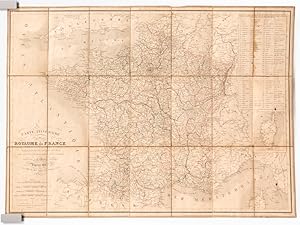
Carte Routi�re de la France � l'usage des Voyageurs. Nouvelle Carte Physique et Routi�re de la France, indiquant toutes les routes de poste, imp�riales et d�partementales, avec les distances compt�es en kilom�tre d'un lieu � un autre, les chemins de fer ex�cut�s et en construction, ainsi que les canaux navigables et les principales rivi�res.
Lingua: Francese
Editore: Auguste Logerot, 1876
Da: Librairie du Cardinal, GRADIGNAN, Francia
Valutazione del venditore 5 su 5 stelle
Mappa
EUR 130,00
Spedizione EUR 25,00
Spedito da Francia a U.S.A.Quantit�: 1 disponibili
Aggiungi al carrellorigide. Condizione: Bon. Carte entoil�e en couleurs sous chemise cartonn�e, au format 94 x 69.5 cm, Auguste Logerot, Paris, 1876.Rappel du titre complet : Carte Routi�re de la France � l'usage des Voyageurs. Nouvelle Carte Physique et Routi�re de la France, indiquant toutes les routes de poste, imp�riales et d�partementales, avec les distances compt�es en kilom�tre d'un lieu � un autre, les chemins de fer ex�cut�s et en construction, ainsi que les canaux navigables et les principales rivi�res. Belle carte de France en couleurs (qq. anciennes traces de crayon de couleurs soulignant la fronti�re du Rhin). Langue: Fran�ais.
-
Carte itin�raire du Royaume de France, indiquant toutes les Routes de Poste, ainsi que les d�partementales et les Canaux
Lingua: Francese
Editore: Chez Binet, 1837
Da: Librairie du Cardinal, GRADIGNAN, Francia
Valutazione del venditore 5 su 5 stelle
Mappa
EUR 175,00
Spedizione EUR 25,00
Spedito da Francia a U.S.A.Quantit�: 1 disponibili
Aggiungi al carrellosouple. Condizione: Assez bon. Dress�e par A.R. Fr�min, Chez Binet, Paris, 1837, 1 carte d�pliante entoil�e format 76,3 x 59,5 cm, limites des d�partements rehauss�es en couleurs Jolie carte de France. Etat tr�s satisfaisant (petites taches d'encre et qq. brunissures). Langue: Fran�ais.
-
Nouvelle Carte physique et routi�re de la France. Indiquant toutes les routes des Postes imp�riales et d�partementales, avec les distances compt�es en kilom�tres, d'un lieu � un autre, les chemins de fer ex�cut�s et en construction ainsi que les canaux navigables et les principales rivi�res dress�e par A.R. FREMIN d'apr�s les cartes de la Marine, celles des Ponts-et-Chauss�es et des Postes.
Lingua: Francese
Editore: Paris, LOGEROT, 1871, 1871
EUR 150,00
Spedizione EUR 52,00
Spedito da Francia a U.S.A.Quantit�: 1 disponibili
Aggiungi al carrelloCouverture souple. Condizione: Bon. Chemise en percaline rouge, premier plat orn� du titre estamp� renfermant une carte de France repli�e (800 x 650mm) orn�e de 3 cartons figurant les environs de Paris , l'Alg�rie et la Corse. (l�gers frottements au dos de la chemise, la carte pr�sente de p�les rousseurs et une petite fente � un pli). Rare.
-

NOUVELLE CARTE PHYSIQUE ET ROUTIER DE LA FRANCE
Editore: AUG. LOGEROT, 1850
Da: Le-Livre, SABLONS, Francia
Membro dell'associazione: ILAB
Valutazione del venditore 5 su 5 stelle
EUR 65,25
Spedizione EUR 42,00
Spedito da Francia a U.S.A.Quantit�: 1 disponibili
Aggiungi al carrelloCouverture souple. Condizione: bon. R200014372: 1850. In-12. Broch�. Bon �tat, Couv. convenable, Dos satisfaisant, Int�rieur frais. 1 carte d�pliante 90/68. . . . Classification Dewey : 900-GEOGRAPHIE, HISTOIRE, SCIENCES AUXILIAIRES DE L'HISTOIRE.
-
EUR 47,00
Spedizione EUR 17,50
Spedito da Austria a U.S.A.Quantit�: 1 disponibili
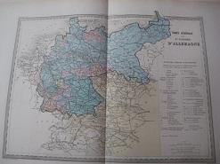
Aggiungi al carrello58,5 x 40 cm. Carte Generale de L`Empire d`Allemagne von A.R. Fremin, hrsg. Paris, Fosset, 1866, Stahlstich grenzkoloriert, Format 58,5 x 66 cm sehr guter Zustand, genuine map Sprache: Deutsch Gewicht in Gramm: 550.
-
Atlas de la Bible dite de Vence, sans doute l'�dition de 1825. (manque page de titre)
Editore: Barriere s.d. (ca 1825) paris, 1825
EUR 170,00
Spedizione EUR 10,00
Spedito da Francia a U.S.A.Quantit�: 1 disponibili
Aggiungi al carrello1 vol grand In4 . Bon �tat. Oblong, � l'italienne, cartonnage recouvert de papier d'attente de l'�poque, frott� sur bords, sans dos,(en attente du cuir) comprenant 37 belles planches grav�es sur un beau papier XVIII�, certaines sous serpente (par Barri�re Fr�res, 1820 -1824), dont 12 cartes dress�es par Fr�min, 17 plans d'ouvrages architecturaux ou d�tails de pi�ces ornementales, 7 gravures concernant des objets (vases d'airain, chandeliers, instruments de musique.), 1 planche d'alphabets de langues orientales dans lesquelles la bible a �t� traduite. Bon �tat int�rieur. Quelques piqures en marge et une pale mouillure affectant un grand angle inf�rieur droit de tout l'ouvrage. Cachet de biblioth�que sur page de garde. Photos sur demande.
-

Carte de L `Oceanie, map, anno 1844
Editore: Fremin, A.R., Paris
Da: Hammelburger Antiquariat, Hammelburg, Germania
Valutazione del venditore 5 su 5 stelle
EUR 159,00
Spedizione EUR 30,00
Spedito da Germania a U.S.A.Quantit�: 1 disponibili
Aggiungi al carrelloHardcover. Condizione: very good. Carte de L `Oceanie, map, anno 1844 "Carte de L Oceanie" old steel engraved map by S. Jacobs, edited by Fremin, A.R. sheet size ca. 38 x 51 cm map ca. 30 x 42 cm - centerfolded, slightly browned, partly spotted -.
-
CARTE ROUTIERE de la FRANCE � l'usage des voyageurs. Nouvelle carte physique et routi�re de la France indiquant toutes les routes nationales et d�partementales ; avec les distances compt�es en kilom�tres ( d'un lieu � un autre. ) les chemins de fer �x�cut�s et en construction ainsi que les canaux navigables et les principales rivi�res, d'apr�s les cartes de la Marine, celles des Ponts et Chauss�es et des postes.
Da: Librairie les mains dans les poches, Tourbes, Francia
Valutazione del venditore 5 su 5 stelle
EUR 36,00
Spedizione EUR 45,00
Spedito da Francia a U.S.A.Quantit�: 1 disponibili
Aggiungi al carrelloCondizione: Bon. Paris, J. Gaultier �diteur, 1900. Carte d�pliante ( 68x93,5 cm ) grav�e sur acier et tir�e en couleurs.; in-12, chemise cartonn�e �diteur, papier grenu cerise, demi-toile rouge, titre dor� sur le premier plat. Nouvelle �dition, orn�e en carton, des cartes de Paris, de l'Alg�rie, et de la Corse. Exemplaire bien conserv� malgr� des pliures fragiles. Scotch au dos de la carte. La librairie offre aux clients d'AbeBooks 20% de r�duction sur l'ensemble de son catalogue. Prix d'origine : 45 EUR.
-
Hardcover. Condizione: Good. No jacket. Circa 1838. "Adopte dans les maisons d'education." In French. 37 maps collated complete. Covers worn, especially along edges. Front flyleaf missing 1/3. Some foxing. As-Is.
-
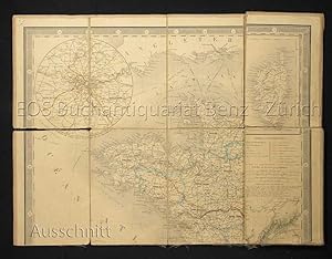
Nouvelle carte physique et routi�re de la France. Toutes les routes de poste, royales et d�partementales, avec les distances compt�es en kilom�tres d'un lieu a un autre. Les chemins de fer �x�cut�s et en construction ainsi que les canaux navigables et les pincipales rivi�res. Dress� par A.R. Fremin, Geogrpahe, d'apr�s les cartes de la marine, celles de ponts et chauss�es et des postes.
Editore: Paris, Augte. Logerot, 1853
Da: EOS Buchantiquariat Benz, Z�rich, Svizzera
Membro dell'associazione: ILAB VEBUKU
Valutazione del venditore 5 su 5 stelle
Arte / Stampa / Poster
EUR 247,63
Spedizione EUR 25,00
Spedito da Svizzera a U.S.A.Quantit�: 1 disponibili
Aggiungi al carrelloLithogr. Karte auf Leinen aufgezogen. Blattformat: 70 x 93 cm. Die Karte mit Gebrauchsspuren. Mehrfach eingerissen. + Wichtig: F�r unsere Kunden in der EU erfolgt der Versand alle 14 Tage verzollt ab Deutschland / Postbank-Konto in Deutschland vorhanden +.
-
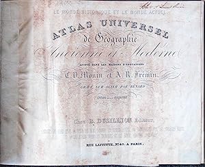
Le Monde Historique et le Monde Actuel. Atlas Universel de Geographie Ancienne et Moderne, Adopte dans les Maisons d'Educations
Editore: Paris, Paris, 1841
Da: High Ridge Books, Inc. - ABAA, South Deerfield, MA, U.S.A.
Membro dell'associazione: ABAA ESA ILAB SNEAB
Valutazione del venditore 5 su 5 stelle
Original 1/4 leather with pebbled cloth. Some damage with loss to preliminary text leaves, some repairs. One folding cosmological plate, 12 maps of the ancient world, 37 of the modern, all hand-colored in outline.
-
Atlas g�ographique et g�ologique des quatre parties du monde et de la France en particulier. Pr�c�d� d'un essai sur la g�ographie naturelle et physique du globe . d'apr�s les excellents ouvrages de MM. Cuvier, Brongniart et autres savants. First edition.
Editore: Paris: Augustin.Legrand & Dondey-Dupr� et Fils, 1824
Da: Wittenborn Art Books, San Francisco, CA, U.S.A.
Valutazione del venditore 5 su 5 stelle
Condizione: Good. Folio. 29 x 42 cm. Original cardboard "reliure d'attente" with printed labels. 24 maps; 16 in color and 16pp of text. OCLC Number :54232598. Grand in-folio, cartonnage de parution avec �tiquette imprim�e sur le premier plat. Atlas peu courant, compos� de 24 cartes dont 16 en couleur, la plupart sur double page, et de 16 pages de texte. Augustin Legrand annonce que son "ouvrage est enti�rement neuf et en accord avec les cours, trait�s et le�ons � l'usage des coll�ges et maisons d'�ducation." Sur Augustin Legrand, et en particulier sur son r�le p�dagogique, voir la notice de notre confr�re Jacques Desse :"Augustin Legrand. Un pionnier inconnu du livre jeunesse". (En ligne sur Internet). Bon exemplaire.
-
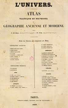
L'Univers. Atlas classique et universel de g�ographie ancienne et moderne. First edition
Editore: Paris: Armand Aubr�e, 1837
Da: Wittenborn Art Books, San Francisco, CA, U.S.A.
Valutazione del venditore 5 su 5 stelle
Arte / Stampa / Poster
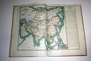
Condizione: Good. Large folio. Contemporary qtr. roan and marbled boards, worn. 57 x 40 cm. 37 of 38 double page maps. Includes 9 of the Americas. Light foxing throughout. Uncolored.Introduction by A. Mont�mont, author of Biblioth�que universelle des voyages from which maps no. 1-3 are taken.OCLC Number:2791319Notes by David Rumsey to his copy:"Accompanies Montemont's Histoire Universellle Des Voyages. Large Folio atlas. Not in Phillips. 1st page of ancient maps lacking. We can find no record of this atlas, other than the Sabin reference and the Oceanie map in Tooley Aust. Monin and Fremin did a smaller world atlas, offered by Hudson in 1988. These maps are large and impressive. They were published with Montemont's 46 volume History of Voyages, although Sabin calls for an Atlas of 22 maps, whereas this has 38 maps on 36 sheets. Maps are without color and bound in quarter leather brown marbled paper covered boards with "Atlas De L'Histoire Des Voyages" stamped in gold on the spine."G�ographie ancienne 8 cartes en 4 pages.G�ographie moderne Planisph�re sur double page, Mappemonde sur double page. Asie:5 cartes Carte g�n�rale sur double page, Chine, Japon in plano sur double page.Asie M�ridionale,l'Inde 1 page,Turquie d'Asie sur 1 page.Asie Bor�ale sur 1 page. Afrique 5 cartes :Afrique carte g�n�rale in plano sur double page.Asie septentrionale Alger,Maroc Tunisie Tripoli?1 page, Afrique m�ridionale 1 page,Afrique orientale 1 page, Afrique occidentale 1 page.Am�rique 9 cartes : Am�rique m�ridionale in plano sur double page,Am�rique septentrionale in plano sur double page, Mexique et Guatemala 1 page, Etats-Unis et Canada 1 page,Colombie et Guyane 1 page,P�rou et Bolivie 1 page,La plata et le Chili 1 page,Br�sil,Paraguay et Uruguay 1 page,Am�rique Bor�ale 1 page.Europe in plano sur double page,Su�de,Norv�ge et Danemark 1 page,Iles Britanniques 1 page,Espagne et Portugal 1 page,Turquie Orientale 1 page,Turquie d'Europe et Gr�ce 1 page.Italie,Suisse et Tyrol. In-folio � basane havane �p. 37 (sur 38) cartes grav�es sur double page, � pleine page ou 2 par page. Manque la carte "Alger, Maroc, Tunis, Tripoli, etc.". Frott�s et �pidermures.
-
Sacra Bibbia di Vence : prima edizione italiana - opera dedicata a S. M. I. R. A. Francesco 1. Atlante contenente le carte geografiche ed iconografiche relative al testo ed alle dissertazioni
Editore: Fortunato Stella e Figli, Milano, 1833
Da: ERIC CHAIM KLINE, BOOKSELLER (ABAA ILAB), Santa Monica, CA, U.S.A.
Membro dell'associazione: ABAA ILAB
Valutazione del venditore 4 su 5 stelle
Prima edizione
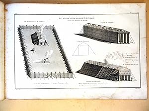
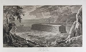
Hardcover. Condizione: f to vg. First Italian edition. Oblong folio (12 6/8 x 18 1/2"). [1] leaf (Title), 38 leaves (Plates), [1] leaf (List of content). Original half morocco over burgundy paper covered boards. Gold lettering and tooling on spine. Rare first Italian edition of Paul-Louis-Bernard Drach's atlas volume of his "Sainte Bible de Vence," a series which was originally published in 27 volumes in Paris from 1827 to 1833. The striking 38 engraved plates featured in this atlas are composed of 13 maps by A. R. Fremin and 25 engravings signed by Falkeisen, Angelini and Lanzani. The engraved plates have been laid down on beautiful hand-made paper, and describe the following: 1. Map of the place of Eden (Mesopotamy and Persian Gulf); 2. Noah's Arch construction; 3. Noah's Arch; 4. Map of the land divided among Noah's sons; 5. The Babel Tower; 6. Map of the Land of Canaan; 7. Map of Jews' Pilgrimage; 8. The Jerusalem Sahnedrin; 9. The Temple of Jerusalem (plans and sections); 10. The Temple of Jerusalem (square plan); 11. Map of ancient Jerusalem; 12. The Temple of Salomon; 13. The Temple's foundations; 14. The East Gate; 15. The Buildings of the Temple; 16. Musical Instruments of the Jews; 17. Hebrew Alphabet; 18. Jew's Vestments and worship's objects; 19. Two Menorah; 20. High Priest's vestments and Golden Menorah; 21. Moses' Tabernacle; 22. The Loaves of Proposition; 23. Plan and section of the Tabernacle; 24. The encampment of the Israelites; 25. Map of the Holy Land (South); 26. Map of the Holy Land (North); 27. Map of Syria; 28.Map of Israel under Salomon; 29. Plan of the House of the Forest of Lebanon; 30. The House of the Forest of Lebanon; 31. The Bronze Sea; 32. The Washings; 33. The Altars of the Holocausts; 34. Map of the Persian Empire; 35. Map of the Land of Canaan according to Ezechiel; 36. Map of Herod's Reign; 37. Zachary's Vision; 38. Map of the travels of Saint Peter and Saint Paul. The plates measure appr. 12 1/2 x 18 1/4" (image size appr. : 9 1/2 x 14 6/8"). Binding rubbed on covers and along edges. Head and tail of spine chipped. Previous owner's Ex-libris (Calvin Bullock) on inside of front cover. Minor and sporadic foxing along paper margin (not affecting plates). Title and captions in Italian. Binding in overall fair, interior in very good, plates in near fine to fine condition. About the author: "David Paul Drach (aka Paul-Louis-Bernard Drach after his conversion) (1791-1865), was a Catholic convert from Judaism, and librarian of the College of Propaganda in Rome. Drach received his early education from his father, who was a rabbi. After spending some time in various Talmudic schools, he became a teacher at Rappoltsweiler, though only sixteen years of age. The love of the secular sciences brought him to Paris, where he was welcomed by his coreligionists, and became tutor in a wealthy Jewish family. His reputation as a teacher brought him Christian pupils; and this may have had some influence on his subsequent conversion; in fact, he had always manifested some leaning toward Christianity. Drach had already begun the study of Greek and Latin so as to become acquainted with the Christian doctrines in their original sources. Struck by the accusation of some of the Fathers that the Jews had corrupted the Hebrew text, he began a comparative study of the Hebrew and the Septuagint, which study he continued in spite of the remonstrances of the president of the Central Consistory. Drach was received into the Catholic faith in 1823, together with his two daughters and his son Paul, who afterward became a priest and a distinguished Biblical scholar. In 1827 Drach accepted the position of librarian of the Propaganda in Rome, which position he held until the year of his death." (From the Jewish Encyclopedia).
-
Atlas.
Editore: Paris, Monrocq & Geisend�rfer for Auguste Logerot, ca. 1879., 1879
Da: Antiquariat INLIBRIS Gilhofer Nfg. GmbH, Vienna, A, Austria
Membro dell'associazione: ILAB VDA VDAO
Valutazione del venditore 5 su 5 stelle
EUR 4.000,00
Spedizione EUR 30,00
Spedito da Austria a U.S.A.Quantit�: 1 disponibili
Aggiungi al carrello8 jigsaw puzzles, 302 x 228 mm each: lithographs in original hand colour, laid down to wood panels. Relief shown by hachures. Stored in decorative box (320 x 250 x 55 mm). Charming hand-coloured geographical puzzle set, manufactured by Logerot in Paris, rarely encountered complete and with eight maps: World, North America, South America, Europe, Asia, Africa, Oceania, and France. Puzzles of this type were first produced in London by John Spilsbury in the 1760s, but the style passed to the continent and became a popular educational tool in France and Germany in the early to mid 19th century. Logerot issued his puzzles from the 1850s onwards; the European borders of this set point to a production date between 1878 and 1880. The puzzle maps are stored in the box fully assembled, each resting on a paper mat with cloth tabs for easy retrieval. - In excellent condition. - Cf. OCLC 56131950. Tooley III, p. 148 ("99 jugsaw puzzles, c. 1850").
-
Amerique Septentrionale
Lingua: Francese
Editore: Paris, 1847
Da: T. W. Palmer Books, Eugene, OR, U.S.A.
Valutazione del venditore 4 su 5 stelle
Mappa Prima edizione
No Binding. Condizione: Very Good. No Jacket. 1st Edition. Paper 30.5 x 40 cm Neat line 22 x 30 cm Engraving impression 26 x 35 Engraved map with outline color. Above neat line: Geographie moderne Pl. 75 Below neat line: Dressee par A. R. Fremin Amerique Russe but USA north west extends between 42 degrees and 54 degrees 40 minutes north, and Texas is included with a vague western border. Date based on these boundaries. Some mountains portrayed by hachure. Good rag paper is uniformy age darkened with tiny chips on top. No folds nor evidence of ever being in a book or atlas.