
Importo totale (1 articolo articoli):
Destinazione ordine:

abraham goos (15 risultati)
Vai alla pagina principale dei risultati di ricerca
Filtri di ricerca
Tipo di articolo
- Tutti i tipi di prodotto
- Libri (8)
- Riviste e Giornali (Nessun altro risultato corrispondente a questo perfezionamento)
- Fumetti (Nessun altro risultato corrispondente a questo perfezionamento)
- Spartiti (Nessun altro risultato corrispondente a questo perfezionamento)
- Arte, Stampe e Poster (4)
- Fotografie (Nessun altro risultato corrispondente a questo perfezionamento)
- Mappe (3)
- Manoscritti e Collezionismo cartaceo (Nessun altro risultato corrispondente a questo perfezionamento)
Condizioni Maggiori informazioni
- Nuovo (4)
- Come nuovo, Ottimo o Quasi ottimo (1)
- Molto buono o Buono (3)
- Discreto o Mediocre (Nessun altro risultato corrispondente a questo perfezionamento)
- Come descritto (7)
Legatura
- Tutte
- Rilegato (3)
- Brossura (Nessun altro risultato corrispondente a questo perfezionamento)
Ulteriori caratteristiche
- Prima ed. (1)
- Copia autograf. (Nessun altro risultato corrispondente a questo perfezionamento)
- Sovracoperta (Nessun altro risultato corrispondente a questo perfezionamento)
- Con foto (13)
- Non Print on Demand (14)
Lingua (1)
Spedizione gratuita
Paese del venditore
Valutazione venditore
-

Nieuw Nederlands Caertboeck: Waer in volkomentlijcker als oyt te voren vertoont werden de XVII: Nederlanden . . .
Editore: Weesp : Robas Productions z.j.
ISBN 10: 9072770722 ISBN 13: 9789072770721
EUR 11,00
Spedizione EUR 20,00
Spedito da Paesi Bassi a U.S.A.Quantit�: 1 disponibili
Aggiungi al carrelloCondizione: Good. Originele zwarte linnen band met zilveropdruk, oblong, ca. 23x16cm, (paginagrote) illustraties in z/w, ongepagineerd.
-

Map of Friesland, Groningen and East Friesland, A5
Editore: Contentum Ltd., Larnaca, Cyprus
Arte / Stampa / Poster
EUR 17,99
Spedizione EUR 14,50
Spedito da Cipro a U.S.A.Quantit�: Pi� di 20 disponibili
Aggiungi al carrelloLoose Leaf. Condizione: New. Reproduction. Original title: Map of Friesland, Groningen and East Friesland German: Karte von Friesland, Groningen und Ostfriesland French: Carte de Friesland, Groningue et Frise de l'Est Spanish: Mapa de Frisia, Groningen y Frisia Oriental High-quality fine-art reproduction based on an original work from the Rijksmuseum. Creation period: 17th century (1649). Professionally printed on premium fine-art paper (Photo Matt Fibre) in size A5. The motif is printed with a white border (museum-style presentation). No.
-

EUR 17,99
Spedizione EUR 14,50
Spedito da Cipro a U.S.A.Quantit�: Pi� di 20 disponibili
Aggiungi al carrelloLoose Leaf. Condizione: New. Reproduction. Original title: Map of the Seventeen Provinces German: Karte der Siebzehn Provinzen French: Carte des dix-sept provinces Spanish: Mapa de las 17 Provincias High-quality fine-art reproduction based on an original work from the Rijksmuseum. Creation period: 17th century (1630). Professionally printed on premium fine-art paper (Photo Matt Fibre) in size A5. The motif is printed with a white border (museum-style presentation). No.
-

Map of the county of Holland, 1630, A5
Editore: Contentum Ltd., Larnaca, Cyprus
Arte / Stampa / Poster
EUR 17,99
Spedizione EUR 14,50
Spedito da Cipro a U.S.A.Quantit�: Pi� di 20 disponibili
Aggiungi al carrelloLoose Leaf. Condizione: New. Reproduction. Original title: Map of the county of Holland, 1630 German: Karte der Grafschaft Holland, 1630 French: Carte du comt� de Holland, 1630 Spanish: Mapa de la provincia de Holanda, 1630 High-quality fine-art reproduction based on an original work from the Rijksmuseum. Creation period: 17th century (1630). Professionally printed on premium fine-art paper (Photo Matt Fibre) in size A5. The motif is printed with a white border (museum-style presentation). No.
-

Nieuw Nederlands Caertboeck: Waer in volkomentlijcker als oyt te voren vertoont werden de XVII: Nederlanden . . .
Editore: Weesp : Robas Productions z.j.
ISBN 10: 9072770722 ISBN 13: 9789072770721
Da: Mooney's bookstore, Den Helder, Paesi Bassi
Valutazione del venditore 4 su 5 stelle

EUR 26,65
Spedizione EUR 14,95
Spedito da Paesi Bassi a U.S.A.Quantit�: 1 disponibili
Aggiungi al carrelloCondizione: Very good.
-
Nieuw Nederlandtsch Caertboeck. Waer in volkomentlijcker als oyt te voren vertoont werden de XVII. Nederlanden, Too in 't geheel, als elck besonder met grote neersticheyt ende kosten gesneden ende in 't licht gebracht door Abraham Goos. .
Editore: Abraham Goos, Amsterdam, 1616
Da: Arader Books, New York, NY, U.S.A.
Valutazione del venditore 5 su 5 stelle

Prima edizione
Hardcover. Condizione: Near fine. First. First edition, second state (or second edition; see below). Amsterdam: Abraham Goos, 1616. Oblong quarto (6 3/8" x 8 5/16", 162mm x 210mm). [Full collation available.] With an engraved title-page and 23 engraved maps integral to the text. Bound in contemporary vellum over paste-board, with a blind fillet border. Title and shelf-mark (709.) ink manuscript to spine, with an additional shelf-mark (66) in red ink manuscript to spine. With eight ties (perished). All edges of the text-block glazed blue. Rear lower fore-corner restored. Ties perished. Small gash to the spine, with some wear at the head and tail. Front board splayed a little. Wear to the front paste-down from the removal of a bookplate. Internally a lovely copy, with a pale water-stain to the lower margin, scarcely affecting text. Good margins and a strong impression. Gilt red sheep ex-libris of Carlo De Poortere to the recto of the first free end-paper. Ink ownership signature in an old hand to the half-title-page. Abraham Goos (1590-ca. 1643) was at the very heart of the Dutch cartographic community; he learned from Jodocus Hondius and partnered with Jan Janssonius. Goos is best known as the first publisher of a Hebrew-language map of the Holy Land (as the initial of the dedication with its tetragrammaton hints), and as the father of Pieter Goos, who was a highly successful mapmaker in his own right. Koeman and Van der Kroegt both single him out as "an excellent craftsman," outstripping his colleagues. The Nieuw Nederlandtsch Caertboeck is his only publication proper, with 2 maps of the Low Countries generally and 21 maps of the 17 individual states: one for each of the Seventeen Provinces (except Drenthe, which is included in map 22: Trans-isulana (Overijssel)), four additional maps of Holland and one additional map of Brabant (map 18, Marchionatus Sacri Imperii (Antwerp)). Each map is a stadium, with arabesque corner-ornaments. Koeman recognizes only one Goos edition, but Van der Kroegt's reissue of Koeman's Atlantes Nederlandici distinguishes two "editions," of which ours is the second (the imprint changes to include Goos's new address "inde Kalverstraet"). It is not clear to what extent this is a true setting-from-fresh of the type, or if it is in fact a change of issue or state; the typesetting of the book seems not to have changed, and the maps are identical. Of the early (late XVIIc?) ownership signature nothing can be written. Carlo De Poortere (1917-2002), the great Belgian bibliophile, amassed one of the finest libraries of continental (and especially Netherlandish) illustrated books. The present volume was not in his major sale at Sotheby's Paris (6 November 2014), but passed through the rooms of Drouot/Van de Wiele (10 October 2020, lot 895) and Reiss & Sohn (10 May 2021, lot 1894). Koeman Goo 1, Shirley T.Goos-1a, Van der Kroegt/Koeman 363:01B.
-
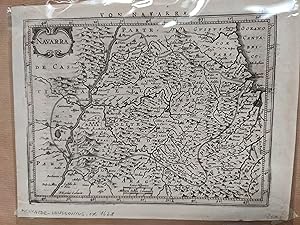
Navarra. Mapa
Editore: circa 1628, Pa�ses Bajos, 1628
Da: LIBRERIA ANTICUARIA LUCES DE BOHEMIA, ZARAGOZA, Z, Spagna
Membro dell'associazione: AILA ILAB LIBRIS
Valutazione del venditore 5 su 5 stelle
EUR 200,00
Spedizione EUR 75,00
Spedito da Spagna a U.S.A.Quantit�: 1 disponibili
Aggiungi al carrelloMapa grabado, texto en el reverso en aleman. Escala [ca. 1:512.000], 4 leucae hispaniarum [=2,5 cm]; 4 milliaria Gallica communea [2,5 cm] 23,50x18 cm. (tama�o del papel).
-
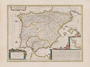
Hispaniae Veteris Descriptio.
Editore: Amsterdam, Janssonius, [c.]., 1662
Da: Inanna Rare Books Ltd., Skibbereen, CORK, Irlanda
Valutazione del venditore 5 su 5 stelle
Arte / Stampa / Poster
EUR 475,00
Spedizione EUR 28,00
Spedito da Irlanda a U.S.A.Quantit�: 1 disponibili
Aggiungi al carrelloOriginal hand-coloured copper engraving. Plate Size: 49.2 cm x 37 cm. Sheet Size: 59.8 cm x 45 cm. Original map. Very good condition. Faint hint of foxing along left fore edge. Centre fold as issued. Latin text on reverse. [Koeman I, 6000H:1.2]. Border with longitudinal and latitudinal information. A richly detailed and very interesting map showing Roman Hispania - the Iberian Peninsula and the Balearic Islands. The three Ancient Roman provinces (organised by the emperor Augustus) of Hispania Citerior et Tarraconensis, Hispania Baetica and Lusitania Hispania are shown on the map. Northern tip of Africa ('Hispania Transfretana Sive Tingitana, Qua et Mauritania') pictured also. Relief shown pictorially with rivers, mountains and significant towns and cities depicted. Large decorative cartouche with finely detailed Classical allusions in lower right section of map contains an inset box showing the coastal area around 'Gades' (Cadiz). Cartouche also lists numerous place names of uncertain location (in Latin). Bar-scales within cartouche in top right corner of the map. Decorative title cartouche in lower left corner. Three ships are also pictured suggesting the region's maritime importance. 'Mare Mediterraneum Internum' and 'Ocean Atlanticus, Quod et Mare Hesperium, Vespertinum Occiduum, et Externum' are also listed. Abraham Goos (1590 c. 1643) was a Dutch cartographer, publisher, and engraver. He made globes, maps of North America, a comprehensive map of European coastlines, and the first printed Hebrew language map of The Holy Land. His first teacher was Jodocus Hondius (15631612), a renowned map-maker, whose son-in-law was Johannes Janssonius. After Hondius died, his son-in-law Jan Janssonius took over Hondius's business and continued the partnership with Goos. One of Hondius' specialties was the manufacture of globes, and Goos and Janssonius continued this, regularly modifying them as more geographical information became available. In 1616 he published Nieuw Nederlandtsch Caertboeck, an atlas of the Seventeen Provinces in 23 maps, and one of the first atlases of the Netherlands; Johannes Janssonius (1588-1664) was a renowned geographer and publisher of the seventeenth century, when the Dutch dominated map publishing in Europe.
-

Hispaniae veteris descriptio
Editore: Artist: Goos Abraham ( - 1643 ) Amsterdam ca : 1620, 1590
Da: Antique Sommer& Sapunaru KG, M�nchen, Germania
Membro dell'associazione: ILAB VDA
Valutazione del venditore 4 su 5 stelle
EUR 820,00
Spedizione EUR 45,00
Spedito da Germania a U.S.A.Quantit�: 1 disponibili
Aggiungi al carrelloTechnic: Copper print, colorit: original colored, condition: Upper and lower margin some tears perfecly restored, size (in cm): 37 x 49 cm, Map shows the Iberian Peninsula with Spain, Portugal, the Balearic Islands and a partial map of the area around C�diz (Andalusia). Furthermore, a title, mileage indicator and index cartouche as well as three ship tafages.
-
Nieuw Nederlandtsch caertboeck. Waer in volkomentlijcker als oyt te voren vertoont werden de XVII. Nederlanden, soo in 't geheel, als elck besonder met grote neersticheyt ende kosten gesneden ende in 't licht gebracht. Mitsgaders een nieuwe beschryvinge uijt verscheyden autheuren ordentlyck tsamen gestelt door Reinier Telle .
Editore: Abraham Goos in de Kalverstraet,, Amsterdam,, 1616
Da: ASHER Rare Books, T Goy Houten, Paesi Bassi
Membro dell'associazione: ILAB NVVA
Valutazione del venditore 5 su 5 stelle
EUR 4.500,00
Spedizione EUR 25,00
Spedito da Paesi Bassi a U.S.A.Quantit�: 1 disponibili
Aggiungi al carrelloRare first edition of one of the first atlases of the Low Countries, with 23 very detailed maps. It is the only atlas published by the mapmaker, Abraham Goos, himself. At the time the present atlas was published, the Seven United provinces (The Northern Netherlands) were still together with the 10 provinces of the Spanish or Habsburg Low Countries. The atlas includes two maps of the Low Countries as a whole, one map of each of the seventeen provinces (except Drenthe, which is included in the map of Overijssel), four additional maps of Holland, and one additional map of Brabant. Goos's maps were also used for the Atlas Minor, published by Johannes Janssonius in 1628.The maps are elegantly designed with decorative title cartouches, finely engraved, and set in a decorative oval rectangular frame, while the corners are decorated in a Renaissance style. The work was reprinted by Janssonius in 1625, and Doncker in 1685. Only the first edition was printed by Goos himself. Koeman recognizes only one Goos issue, but Van der Krogt's reissue of Koeman's Atlantes Nederlandici distinguishes two, of which ours is the second. The two issues are nearly identical, but the second can be recognised by the imprint (which includes Goos's new address "inde Kalverstraet"), and the addition of the text "cum privilegio" to the maps, which Goos added after receiving his privilege for this atlas on 24 December 1615, and an honorarium of 120 guilders from the States General on 8 January 1616. Generally, 20 of the 23 maps of the second issue have this addition, but in the present copy it is 17: the text is not present on maps 3-5, 8, and 11-12.The text was written by the poet and translator Reinier Telle (1559-1618), who based it mainly on Ludovico's Guicciardini's Beschrijvinghe van alle de Nederlanden, translated by Telle in 1613. Telle's text was in turn the main source for the text in De Vyerighe Colom; finally, that text was again used for a new edition of Guicciardini's work, published by Jacob van Meurs in 1660.Abraham Goos (ca. 1590-before 1643) was born in Antwerp as the son of Margaretha van den Keere, the sister of the famous mapmaker Hendrik van den Keere. In 1600 Goos moved to Amsterdam where he soon was employed and trained by the Hondius family and by Willem Jansz. Blaeu. He had his own shop named "In 't vergulde Caertboeck", first located 'op den Dam', later, around 1615, in the Kalverstraat. Pieter Goos, Abraham's son, later became famous for his sea atlases and pilot guides.With an erased ownership's entry at the head of the half-title, and 18th-century annotations on pp. 136-138. The edges and corners of the boards are scuffed, the boards have been rubbed, with some loss of material. The first few leaves are somewhat browned, a repaired hole in the lower margin of the title page, false folds in the half title, some marginal small tears, small holes in 2 leaves, with some loss of text, a repaired tear in the last leaf, a water stain in the outer half of the last few leaves. Otherwise in good condition.l Krogt, P. van der, Koeman's Atlantes Neerlandici, IIIB, � 363, pp. 612-615 (no. 363:01B); Koeman, Atlantes Neerl., II, p. 121 (Goo 1); STCN 853385556; USTC 1032942; cf. for the text: Fontaine Verwey, H. de la, 'Reinier Telle, hekeldichter, pamfletschrijver, vertaler', in: Uit de wereld van het boek, III, pp. 55-86, esp. 68. 19th-century quarter calf, with a manuscript number on the spine ("32"), sprinkled paper sides. With an engraved title page (signed by P.S[erwouter] scul.' (bottom right) after 'D.V[inck] B[oons]' (bottom left)), 23 full page maps, several decorated woodcut initials and woodcut tailpieces. Pages: [7], "305" [=294], [2], [1 blank] pp.
-
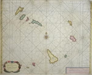
A charte of the island of Cap Verd
Editore: Artist: Goos Abraham ( - 1643 ) Amsterdam ca : 1650, 1590
Da: Antique Sommer& Sapunaru KG, M�nchen, Germania
Membro dell'associazione: ILAB VDA
Valutazione del venditore 4 su 5 stelle
Mappa
EUR 940,00
Spedizione EUR 45,00
Spedito da Germania a U.S.A.Quantit�: 1 disponibili
Aggiungi al carrelloTechnic: Copper print, colorit: colored, condition: Upper left and right corner perfectly replaced, size (in cm): 44 x 54, Map shows the Island of Cap Verde.
-

Orbis Terrae Compendiosa Descriptio ex ea, quam ex Magna Universali Mercatoris Rumoldus.
Editore: Antonii Magini c.1617, Arnhem, The Netherlands, 1617
Da: Alexandre Antique Prints, Maps & Books, Toronto, ON, Canada
Membro dell'associazione: ABAC ILAB
Valutazione del venditore 4 su 5 stelle
Mappa
EUR 1.071,51
Spedizione EUR 5,20
Spedito da Canada a U.S.A.Quantit�: 1 disponibili
Aggiungi al carrelloCondizione: Very Good. Latin text and blank verso.Rare World map, taken from Ioannis Antonii Magini's Geographia Tum Veteris, Tum Nova. It is published in Arnhem in 1617 and edited by Jan Janssonius. The map is specially engraved for this publication by Abraham Goos, inspired by the map of Girolamo Porro of 1597, a reduction of the Mercator globe., Size : 172x246 (mm), 6.77x9.69 (Inches), Black & White.
-
De starre-kunst : leerende de hoedanigheden der beweginge van alle zichtbare Hemelsche Lighamen, en't berekenen haarder zichtbare plaatzen : mitsgaders, de hoedanigheden der verduistering van zon en maan, en de berekeninge van dien 1659 [Leather Bound]
Data di pubblicazione: 2024
Da: Gyan Books Pvt. Ltd., Delhi, India
Valutazione del venditore 5 su 5 stelle
EUR 34,49
Spedizione gratuita
Spedito da India a U.S.A.Quantit�: Pi� di 20 disponibili
Aggiungi al carrelloLeather Bound. Condizione: New. Language: Dutch. Language: Dutch_Flemish. Presenting an Exquisite Leather-Bound Edition, expertly crafted with Original Natural Leather that gracefully adorns the spine and corners. The allure continues with Golden Leaf Printing that adds a touch of elegance, while Hand Embossing on the rounded spine lends an artistic flair. This masterpiece has been meticulously reprinted in 2024, utilizing the invaluable guidance of the original edition published many years ago in 1659. The contents of this book are presented in classic black and white. Its durability is ensured through a meticulous sewing binding technique, enhancing its longevity. Imprinted on top-tier quality paper. A team of professionals has expertly processed each page, delicately preserving its content without alteration. Due to the vintage nature of these books, every page has been manually restored for legibility. However, in certain instances, occasional blurriness, missing segments, or faint black spots might persist. We sincerely hope for your understanding of the challenges we faced with these books. Recognizing their significance for readers seeking insight into our historical treasure, we've diligently restored and reissued them. Our intention is to offer this valuable resource once again. We eagerly await your feedback, hoping that you'll find it appealing and will generously share your thoughts and recommendations. Lang: - Dutch,Flemish, Pages: : - 177, Print on Demand. If it is a multi-volume set, then it is only a single volume. We are specialised in Customisation of books, if you wish to opt different color leather binding, you may contact us. This service is chargeable. Product Disclaimer: Kindly be informed that, owing to the inherent nature of leather as a natural material, minor discolorations or textural variations may be perceptible. Explore the FOLIO EDITION (12x19 Inches): Available Upon Request. 177 177.
-
Antique Map-UTRECHT PROVINCE-ULTRAIECTUM-Goos-1616
Data di pubblicazione: 1616
Da: Pictura Prints, Art & Books, Overasselt, Paesi Bassi
Membro dell'associazione: ILAB NVVA
Valutazione del venditore 5 su 5 stelle
EUR 195,00
Spedizione EUR 20,00
Spedito da Paesi Bassi a U.S.A.Quantit�: 1 disponibili
Aggiungi al carrelloAbraham Goos (illustratore). 'ULTRAIECTUM'The province of Utrecht.Made by Abraham Goos after own design.Medium: Engraving / Etching on hand laid (verge) paper.Sheet size: 21.1 x 15.2 cm (8.31 x 5.98 inch). Image size: 17.4 x 11.8 cm. (6.85 x 4.65 inch).UTRECHT PROVINCE-ULTRAIECTUM | PCO-E14-38BACKGROUND INFORMATIONBy Abraham Goos in 'Nieuw Nederlandtsch Caertboeck.', publ. 1616. Condition: very good, given age. Light ghosting from matting. General age-related toning and/or occasional minor defects from handling. Please study scan carefully.
-

Duchy of Brabant - Abraham Goos + Claes Jansz
Da: Inter-Antiquariaat Mefferdt & De Jonge, Amsterdam, Paesi Bassi
Membro dell'associazione: ILAB NVVA
Valutazione del venditore 3 su 5 stelle

Mappa
EUR 2.150,00
Spedizione EUR 42,00
Spedito da Paesi Bassi a U.S.A.Quantit�: 1 disponibili
Aggiungi al carrelloFAMOUS MAP OF THE DUCHY OF BRABANT "Brabantia Ducatus." Copper engraving by Abraham Goos, published in Amsterdam by Claes Jansz. Visscher in 1622. 2nd state (of 11). Coloured by a later hand. Size 46 � 56.5 cm. The Duchy of Brabant was at the time an extensive territory, stretching far beyond the borders of present-day Belgium and the Netherlands. Much of it was then sparsely populatedlands where wars were fought and territories were gained or lost. The map was published shortly after the Twelve Years' Truce. Visscher incorporated unfolding news events, and the map appeared, repeatedly updated, in no fewer than eleven different states. This particular example shows the punitive expedition led by Prince Frederik Hendrik from Breda to Rustenburg near Leuven between 15 and 22 May 1622, and the devastation of enemy territory, symbolized by countless plumes of smoke rising from burning villages between Leuven and Brussels. In Brabant, the Eighty Years' War was primarily a conflict between Catholics and Protestants. It was a war of fortressescities were captured and recaptured, and borders shifted constantly. Most of Brabant's inhabitants remained loyal to the Spanish king; they did not regard the army of the Prince of Orange as liberators, but as occupiers. After eighty years of warfare, the Peace of M�nster was finally signed in 1648. The duchy was divided in two: southern Brabant remained under Spanish rule, while the northern part became part of the Dutch Republic. Above and below the map image are city views of Leuven, Brussels, Antwerp, 's-Hertogenbosch, Tienen, Bergen op Zoom, Lier, Helmond, Breda, and Mechelen. In the upper corners are portraits of Archduke Albrecht VII of Austria and his wife Isabella of Spain, who jointly ruled the Habsburg Netherlands from 1598 to 1621. To the left and right of the map appear an aristocratic couple, a merchant and his wife, a farmer and his wife, and a man and woman dressed in the costume of Mechelen. In the lower left corner is the coat of arms of the Margraviate of Antwerp; in the lower right, that of Mechelen. Price: Euro 2.150,- (incl. frame).


![Immagine del venditore per De starre-kunst : leerende de hoedanigheden der beweginge van alle zichtbare Hemelsche Lighamen, en't berekenen haarder zichtbare plaatzen : mitsgaders, de hoedanigheden der verduistering van zon en maan, en de berekeninge van dien 1659 [Leather Bound] venduto da Gyan Books Pvt. Ltd.](https://pictures.abebooks.com/inventory/md/md31423810191.jpg)
