Azoren (28 risultati)

Lingua: Tedesco
Editore: O.O. um 1902. 1902
- Manoscritto
Da: Antiquariat Heinz Tessin, Quickborn, GermaniaAntiquariat Heinz Tessin
Contatta il venditoreVenditore con 5 stelleCondizione: Usato
EUR 5,00
EUR 4,00 spedizioneSpedito da Germania a U.S.A.Quantità: 1 disponibili
Aggiungi al carrello9,0 x 14,0 cm. Die Portokosten betragen im Inland 1,00 Euro. [SW-Portugal].

- Brossura
Da: Revaluation Books, Exeter, Regno UnitoRevaluation Books
Contatta il venditoreVenditore con 5 stelleCondizione: Nuovo
EUR 16,95
EUR 14,49 spedizioneSpedito da Regno Unito a U.S.A.Quantità: 1 disponibili
Paperback. Condizione: Brand New. 100 pages. German language. 8.50x5.50x0.25 inches. In Stock.

- Brossura
Da: Untje.com, Roeselare, BelgioUntje.com
Contatta il venditoreVenditore con 5 stelleCondizione: Usato - Buono
EUR 14,00
EUR 72,00 spedizioneSpedito da Belgio a U.S.A.Quantità: 1 disponibili
Aggiungi al carrelloPaperback. Condizione: Good. Naamstempel Dutch.

- Stampa artistica
Da: Antiquariat Martin Barbian & Grund GbR, Saarbruecken, GermaniaAntiquariat Martin Barbian & Grund GbR
Contatta il venditoreVenditore con 5 stelleCondizione: Usato
EUR 30,00
EUR 45,00 spedizioneSpedito da Germania a U.S.A.Quantità: 1 disponibili
Aggiungi al carrelloZwei Stahlstiche nach Sainson auf einem Blatt, um 1834, 20x13 cm, (Stadtansichten / Portugal).
 Altre immagini
Editore: Amsterdam, Valk & Schenk, um 1700. 1700
- Stampa artistica
Da: Antiquariat Thomas Rezek, München, GermaniaAntiquariat Thomas Rezek
Contatta il venditoreVenditore con 5 stelleCondizione: Usato
EUR 240,00
EUR 44,00 spedizioneSpedito da Germania a U.S.A.Quantità: 1 disponibili
Aggiungi al carrellocirca 63,5 x 52 cm. 1 gefaltetes Doppelblatt verso weiß Große Landkarte der zu Portugal gehörenden Inselgruppe der Azoren. Oben Kartusche mit Inschrift, unten Maßstab. - Gut erhalten, schöne Farben und breite Ränder.
 Altre immagini
Azoren-Bojen-Post Schiff Claus Horn 1936, Deutscher Brief nach Bremen, toller Inhalt!
Azoren-Bojen-Post Schiff Claus Horn 1936, Deutscher Brief nach Bremen, toller Inhalt!
Editore: Azoren 1936 1936
- Manoscritto
Da: Antiquariat Thomas Mertens, Berlin, GermaniaAntiquariat Thomas Mertens
Contatta il venditoreVenditore con 4 stelleCondizione: Usato - Molto buono
EUR 480,00
EUR 55,00 spedizioneSpedito da Germania a U.S.A.Quantità: 1 disponibili
Aggiungi al carrelloKein Einband. Condizione: Gut. Azoren-Bojen-Post Schiff Claus Horn 1936, Deutscher Brief nach Bremen, toller Inhalt! Sehr seltener Beleg der Azoren-Bojenpost, die vom Schiff aus in einer Boje ins Meer geworfen wurde und von Fischern aufgesammelt und zur Poststation gebracht wurde, für die dafür Schnaps und Speck zur Belohnung in… der Boje lagen. Mit Umschlag der Horn-Linie, mit großem Stempel "Azoren Bojen Post 3. Okt. 1936" und Poststempeln aus Horta (auf der Azoreninsel Faial) vom 7. Oktober 1936; die Boje wurde also innerhalb von vier Tagen gefunden. Rückseitig Vermerk des Empfängers, dass der Brief am 31. Oktober 1936 angekommen ist. Der beiliegende Briefinhalt (fest montiert auf Trägerpappe) datiert an Bord des Motorschiffes Claus Horn, den 1. Oktober 1936, geschrieben von einem A. Rosenthal in Haiti; gerichtet an Gerd Will in Bremen (lt. Adressbuch Vertretungen in Tabak-Fabrikaten), mit sehr interessantem Inhalt (Erklärung der Bojenpost): "An Bord wird die Post in eine verzinkte Tonne verpackt und bei den Azoren, wo wir morgen vorbeifahren, ins Meer geworfen. Hier, mit viel Glück, wollen die Fischer die Tonne finden und weiterbefördern. An Porto legen wir das Doppelte bei, ebenso eine Ecke Speck und eine Pulle Schnaps, um die Bemühungen der Fischer zu entlohnen. Ich höre gern, ob der Brief Euch erreicht und in welchem Zustand." Azoren 1936 Der Umschlag (mit drei portugiesischen Briefmarken) im Format 13,3 x 16,6 cm; der Brief 26 x 20 cm. Der Umschlag wurde lose (entnehmbar) auf ein Schaublatt montiert, darüber und darunter gedruckte Erläuterungen. Der Brief wurde fest auf Trägerpappe montiert. --- Zustand: Etwas fleckig und knittrig.

Lingua: Tedesco
Editore: Frankfurt M Merian 1641
- Mappa
Da: Wiener Antiquariat Ingo Nebehay GmbH, Wien, AustriaWiener Antiquariat Ingo Nebehay GmbH
Contatta il venditoreVenditore con 5 stelleCondizione: Usato
EUR 300,00
EUR 60,00 spedizioneSpedito da Austria a U.S.A.Quantità: 1 disponibili
Aggiungi al carrelloKupferstich-Seekarte nach Blaeu aus J. A. Werdenhagen, De rebus publicis Hanseaticis tractatus, 26 x 35 cm. - Der Atlantik vor Marokko mit Teilen der portugiesischen und spanischen Küste. - Alte Bugschäden sorgfältig restauriert. Broeckema, Maps of the Canary Islands, Nr. 139; Wüthrich II/56/171.
Lingua: Tedesco
Editore: ,,
- Mappa
Da: Antiquariat Werner Steinbeiß, München, GermaniaAntiquariat Werner Steinbeiß
Contatta il venditoreVenditore con 4 stelleCondizione: Usato
EUR 580,00
EUR 9,95 spedizioneSpedito da Germania a U.S.A.Quantità: 1 disponibili
Aggiungi al carrelloMit drei großen Rollwerk-KartuschenGut erhaltenes Exemplar mit vollem Rand, Van den Broecke 24 Sprache: Deutsch Gewicht in Gramm: 1000 32,5 x 46 cm, Blattgröße 43,5 x 54,5.

- Stampa artistica
Da: Galerie Joseph Fach GmbH, Oberursel im Taunus, GermaniaGalerie Joseph Fach GmbH
Contatta il venditoreVenditore con 5 stelleCondizione: Usato - Ottimo
EUR 100,00
EUR 45,00 spedizioneSpedito da Germania a U.S.A.Quantità: 1 disponibili
Aggiungi al carrelloCondizione: sehr guter Zustand. Pochoir, auf Bütten mit Wasserzeichen: Journal des Dames. 17,8:11 cm. Aus Journal des Dames et des Modes", Costumes Parisien, 1914, 144. This is a plate-signed hand-coloured pochoir illustration from the 1914 Journal des Dames et des Modes - a Parisian haute couture journal containing these(unboun…d) artworks published by Tom Antongini from June 1912 until August 1914.

- Stampa artistica
Da: Galerie Joseph Fach GmbH, Oberursel im Taunus, GermaniaGalerie Joseph Fach GmbH
Contatta il venditoreVenditore con 5 stelleCondizione: Usato - Ottimo
EUR 100,00
EUR 45,00 spedizioneSpedito da Germania a U.S.A.Quantità: 1 disponibili
Aggiungi al carrelloCondizione: sehr guter Zustand. Pochoir, auf Bütten mit Wasserzeichen: Journal des Dames. 17,8:11 cm. Aus Journal des Dames et des Modes", Costumes Parisien, 1913, 126. This is a plate-signed hand-coloured pochoir illustration from the 1914 Journal des Dames et des Modes - a Parisian haute couture journal containing these(unboun…d) artworks published by Tom Antongini from June 1912 until August 1914.

Lingua: Tedesco
- Stampa artistica
Da: Antiquariat Clemens Paulusch GmbH, Berlin, GermaniaAntiquariat Clemens Paulusch GmbH
Contatta il venditoreVenditore con 5 stelleCondizione: Usato
EUR 75,00
EUR 26,90 spedizioneSpedito da Germania a U.S.A.Quantità: 1 disponibili
Aggiungi al carrelloLithographie aus Karlsruher Unterhaltungsblatt, 1829, 17 x 22.

Lingua: Tedesco
- Prima edizione
- Mappa
Da: Antiquariat Clemens Paulusch GmbH, Berlin, GermaniaAntiquariat Clemens Paulusch GmbH
Contatta il venditoreVenditore con 5 stelleCondizione: Usato
EUR 80,00
EUR 26,90 spedizioneSpedito da Germania a U.S.A.Quantità: 1 disponibili
Aggiungi al carrellokoloriert, um 1690, 10,2 x 12,3 From the rare German Edition, printed by Joh. Hoffmann in Nürnberg ( first edition 1678 ) ( with page number "329" - Unten links eine hüb Kartusche ( Schiffsdarstellung).

- Mappa
Da: Antiquariat Clemens Paulusch GmbH, Berlin, GermaniaAntiquariat Clemens Paulusch GmbH
Contatta il venditoreVenditore con 5 stelleCondizione: Usato
EUR 750,00
EUR 26,90 spedizioneSpedito da Germania a U.S.A.Quantità: 1 disponibili
Aggiungi al carrellodat. 1788, 52,5 x 84 Tooley, Dictionry of Mapmaker, Bd. 1 ( für Bauza ) und Bd. 4 ( für Tofino). - Schöne, sauber erhaltene Karte der Azoren aus dem berühmten spanischen Seeatlas "Atlas Maritimo de Espaba", erschienen 1797 - 1789. .

Lingua: Tedesco
- Mappa
Da: Antiquariat Clemens Paulusch GmbH, Berlin, GermaniaAntiquariat Clemens Paulusch GmbH
Contatta il venditoreVenditore con 5 stelleCondizione: Usato
EUR 100,00
EUR 26,90 spedizioneSpedito da Germania a U.S.A.Quantità: 1 disponibili
Aggiungi al carrelloum 1690, 10,2 x 12,3 Unten links eine hüb Kartusche ( Schiffsdarstellung).

Lingua: Tedesco
- Prima edizione
- Mappa
Da: Antiquariat Clemens Paulusch GmbH, Berlin, GermaniaAntiquariat Clemens Paulusch GmbH
Contatta il venditoreVenditore con 5 stelleCondizione: Usato
EUR 100,00
EUR 26,90 spedizioneSpedito da Germania a U.S.A.Quantità: 1 disponibili
Aggiungi al carrelloum 1690, 10,2 x 12,3 From the rare German Edition, printed by Joh. Hoffmann in Nürnberg ( first edition 1678 ) ( with page number "329" - Unten links eine hüb Kartusche ( Schiffsdarstellung).

Lingua: Tedesco
- Mappa
Da: Antiquariat Clemens Paulusch GmbH, Berlin, GermaniaAntiquariat Clemens Paulusch GmbH
Contatta il venditoreVenditore con 5 stelleCondizione: Usato
EUR 175,00
EUR 26,90 spedizioneSpedito da Germania a U.S.A.Quantità: 1 disponibili
Aggiungi al carrello1602, 8,3 x 12,2 Krogt, Koemans Atlantes Neerlandici, Bd. III, lat. Ausgabe 1602 oder 1606. - Frühe Karte der Azoreninsel.

Lingua: Tedesco
- Mappa
Da: Antiquariat Clemens Paulusch GmbH, Berlin, GermaniaAntiquariat Clemens Paulusch GmbH
Contatta il venditoreVenditore con 5 stelleCondizione: Usato
EUR 200,00
EUR 26,90 spedizioneSpedito da Germania a U.S.A.Quantità: 1 disponibili
Aggiungi al carrelloum 1710, 22,8 x 34,3 Kupferstich aus Scherer, Heinrich: "Atlas Novus". Dekorative Karte von Nordwestafrika mit Südspanien und der Strasse von Gibraltar. Zeigt auch die Kanarischen Inseln, die Azoren, und die Kapverdischen Inseln. Oben rechts ornamentale Titelkartusche. Links unten kleine Nebenkarte von Teneriffa und Gran Canaria…. Darüber Trachtengruppe mit exotischen Vögeln. Wes Weiteren drei Schiffe und Darstellung einiger einheimischer Tiere, wie Elefant, Kamel, Giraffe und Löwe.

Lingua: Tedesco
- Mappa
Da: Antiquariat Clemens Paulusch GmbH, Berlin, GermaniaAntiquariat Clemens Paulusch GmbH
Contatta il venditoreVenditore con 5 stelleCondizione: Usato
EUR 250,00
EUR 26,90 spedizioneSpedito da Germania a U.S.A.Quantità: 1 disponibili
Aggiungi al carrellomit altem Grenzkolorit, dat. 1814, 50 x 59,5 Broeckema, Maps of the Canary Islands, Nr. 130; La Laguna, Ausstelungskatalog 2008, S.55 mit farb. Abbildung. - Zeigt 4 Karten auf einem Blatt. Die Karten von Madeira und den Azoren jeweils mit einer kleinen Insetansicht. Mittig eine Ansicht des "Teide" ( = the peak of Teneriffe".

Lingua: Tedesco
- Stampa artistica
Da: Antiquariat Clemens Paulusch GmbH, Berlin, GermaniaAntiquariat Clemens Paulusch GmbH
Contatta il venditoreVenditore con 5 stelleCondizione: Usato
EUR 290,00
EUR 26,90 spedizioneSpedito da Germania a U.S.A.Quantità: 1 disponibili
Aggiungi al carrelloKupferstich v. Merian aus Archontologia, 1646, 20,7 x 31,5.

Lingua: Tedesco
- Mappa
Da: Antiquariat Clemens Paulusch GmbH, Berlin, GermaniaAntiquariat Clemens Paulusch GmbH
Contatta il venditoreVenditore con 5 stelleCondizione: Usato
EUR 300,00
EUR 26,90 spedizioneSpedito da Germania a U.S.A.Quantità: 1 disponibili
Aggiungi al carrellodat. 1775, 54 x 38 Nicht bei Broekema, Maps of the Canary Islands. Tooley, Dictionary of Mapmaker, Bd. 1, S. 40. Der "Neptune oriental" erschien erstmals 1745, hier aus der zweiten erweiterten Ausgabe. Hübsche Karte der Makaronesischen Inseln. Die Lage von Madeira wurde korrigiert und überklebt.

Lingua: Tedesco
- Stampa artistica
Da: Antiquariat Clemens Paulusch GmbH, Berlin, GermaniaAntiquariat Clemens Paulusch GmbH
Contatta il venditoreVenditore con 5 stelleCondizione: Usato
EUR 300,00
EUR 26,90 spedizioneSpedito da Germania a U.S.A.Quantità: 1 disponibili
Aggiungi al carrelloKupferstich aus Montanus, die unbekante Neue Welt, 1673, 28,5 x 34.

Lingua: Tedesco
- Mappa
Da: Antiquariat Clemens Paulusch GmbH, Berlin, GermaniaAntiquariat Clemens Paulusch GmbH
Contatta il venditoreVenditore con 5 stelleCondizione: Usato
EUR 400,00
EUR 26,90 spedizioneSpedito da Germania a U.S.A.Quantità: 1 disponibili
Aggiungi al carrellomit altem Grenzkolorit, 1654, 32,5 x 44 Pastoureau, Les Atlas Francais, Duval II A 1654, 30. Oben rechts eine Insetkarte der Insel Terceira.

Lingua: Tedesco
- Mappa
Da: Antiquariat Clemens Paulusch GmbH, Berlin, GermaniaAntiquariat Clemens Paulusch GmbH
Contatta il venditoreVenditore con 5 stelleCondizione: Usato
EUR 500,00
EUR 26,90 spedizioneSpedito da Germania a U.S.A.Quantità: 1 disponibili
Aggiungi al carrelloum 1692, 45 x 60 Bay. Staatsbiblioth., Karte als Kunstwerk, Nr. 39 u. Abb. der Kartusche. Fauser 489 (Angra). - Mit zwei großen Korallenkartuschen, in die unten links eine große Ansicht aus der Vogelschau von Angra do Heroismo (ca. 12 x 23 cm) auf Terceira. Wie oft bei Coronelli etwas Abklatsch.

Lingua: Tedesco
- Mappa
Da: Antiquariat Clemens Paulusch GmbH, Berlin, GermaniaAntiquariat Clemens Paulusch GmbH
Contatta il venditoreVenditore con 5 stelleCondizione: Usato
EUR 500,00
EUR 26,90 spedizioneSpedito da Germania a U.S.A.Quantità: 1 disponibili
Aggiungi al carrello1641, 26 x 35 Broeckema, Maps of the Canary Islands, Nr. 139. Seltene Karte aus Werdenhagen. Am rechten Rand die Titelkartusche, darunter Meilenzeiger, im Kartenbild eine Windrose. Zeigt die Westküste Spaniens und Marokkos. Mit den Kanarischen Inseln, Madeira und den Azoren im Westen.

Lingua: Tedesco
- Mappa
Da: Antiquariat Clemens Paulusch GmbH, Berlin, GermaniaAntiquariat Clemens Paulusch GmbH
Contatta il venditoreVenditore con 5 stelleCondizione: Usato
EUR 800,00
EUR 26,90 spedizioneSpedito da Germania a U.S.A.Quantità: 1 disponibili
Aggiungi al carrellomit altem Grenzkolorit, 1652, 38 x 53 Koeman IV, J. Col 7 (42). Hubbard, Maps in Colom's Atlases: De Vyerighe Colom, 1654, in Mapforum 12, (47). Fünf Karten auf einem Blatt, oben zwei Karten der marokkanischen Atlantikküste südlich von Larache bis Casablanca und von Casablanca bis etwa Agadir. Unten 3 kleine Karten nebeneinander…: links die Küste der Azoreninsel Sao Miguel zwischen Ponta Delgada und Vila Franca do Campo, mittig Plan von Angra do Heroismo auf Terceira und rechts Karte von Madeira mit Porto Santo. Selten, wie alle Karten von Colom. Etwas fleckig.

Lingua: Tedesco
- Prima edizione
- Mappa
Da: Antiquariat Clemens Paulusch GmbH, Berlin, GermaniaAntiquariat Clemens Paulusch GmbH
Contatta il venditoreVenditore con 5 stelleCondizione: Usato
EUR 850,00
EUR 26,90 spedizioneSpedito da Germania a U.S.A.Quantità: 1 disponibili
Aggiungi al carrello1646, 47 x 36,5 (H) Norwich, Maps of Africa, 251. Seltene Seekarte aus der Erstausgabe des berühmten Seeatlas, noch ohne das in der 2. Ausgabe hinzugefügte 'Lo.6o' in der Kartusche. Zeigt den Atlantik nördlich von der Insel Corvo, die Phantominsel Mayda (hier "Maidas") im Zentrum. Mit Windrose und Segelschiff.

Lingua: Tedesco
- Mappa
Da: Antiquariat Clemens Paulusch GmbH, Berlin, GermaniaAntiquariat Clemens Paulusch GmbH
Contatta il venditoreVenditore con 5 stelleCondizione: Usato
EUR 850,00
EUR 26,90 spedizioneSpedito da Germania a U.S.A.Quantità: 1 disponibili
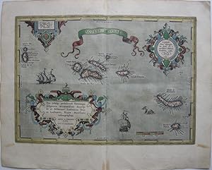
Aggiungi al carrellomit Grenz- u. Flächenkolorit, lat. Ausgabe 1592 -, 1612, 32,5 x 46 Van den Broecke, Nr. 24. ( aus einer lat. Ausgabe 1592/ 1595, 1601/ 1603 /1609 oder 1612 ) - Mit 3 großen altkol. Rollwerkskartuschen. Zeigt die zu Portugal gehörige Inselgruppe. Sehr dek.Karte mit Schiffen und Meeresungeheuern.
Lingua: Tedesco
- Mappa
Da: Antiquariat Clemens Paulusch GmbH, Berlin, GermaniaAntiquariat Clemens Paulusch GmbH
Contatta il venditoreVenditore con 5 stelleCondizione: Usato
EUR 750,00
EUR 26,90 spedizioneSpedito da Germania a U.S.A.Quantità: 1 disponibili
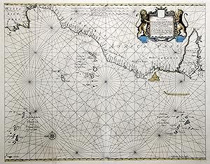
Aggiungi al carrellomit Grenzkolorit, um 1650, 42 x 54 Krogt. Koeman's Atlantes Neerlandici, Bd. 1, Seite 567 ( Abbildung 0150:1 - lat. Ausgabe ). - Seltene, ostorientierte Seekarte, die mittig die Kanarischen Inseln zeigt. Im Nordwesten die Azoren, im Nordosten die Straße von Gibraltar, im Südosten C. Verde, im Südwesten die Kapverdischen Inseln.…- Durchgehend leicht gebräunt, Bugfalte im unteren Bereich restauriert.


