Importo totale (1 articolo articoli):
Destinazione ordine:

bartholomew john r (67 risultati)
Vai alla pagina principale dei risultati di ricerca
Filtri di ricerca
Tipo di articolo
- Tutti i tipi di prodotto
- Libri (53)
- Riviste e Giornali (Nessun altro risultato corrispondente a questo perfezionamento)
- Fumetti (Nessun altro risultato corrispondente a questo perfezionamento)
- Spartiti (Nessun altro risultato corrispondente a questo perfezionamento)
- Arte, Stampe e Poster (Nessun altro risultato corrispondente a questo perfezionamento)
- Fotografie (Nessun altro risultato corrispondente a questo perfezionamento)
- Mappe (14)
- Manoscritti e Collezionismo cartaceo (Nessun altro risultato corrispondente a questo perfezionamento)
Condizioni Maggiori informazioni
- Nuovo (27)
- Come nuovo, Ottimo o Quasi ottimo (19)
- Molto buono o Buono (5)
- Discreto o Mediocre (Nessun altro risultato corrispondente a questo perfezionamento)
- Come descritto (16)
Legatura
Ulteriori caratteristiche
- Prima ed. (12)
- Copia autograf. (Nessun altro risultato corrispondente a questo perfezionamento)
- Sovracoperta (12)
- Con foto (35)
- Non Print on Demand (54)
Lingua (2)
Spedizione gratuita
Paese del venditore
Valutazione venditore
-
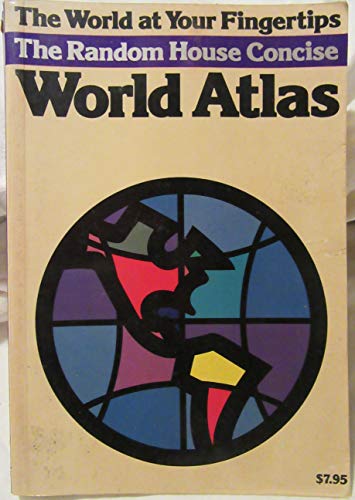
Random House Concise World Atlas
Lingua: Inglese
Editore: Random House Information Group, 1985
ISBN 10: 0394740076 ISBN 13: 9780394740072
Da: Better World Books, Mishawaka, IN, U.S.A.
Valutazione del venditore 5 su 5 stelle

Condizione: Good. Pages intact with minimal writing/highlighting. The binding may be loose and creased. Dust jackets/supplements are not included. Stock photo provided. Product includes identifying sticker. Better World Books: Buy Books. Do Good.
-

The Random House Mini World Atlas
Lingua: Inglese
Editore: Random House Information Group, 1985
ISBN 10: 0394740084 ISBN 13: 9780394740089
Da: Better World Books: West, Reno, NV, U.S.A.
Valutazione del venditore 5 su 5 stelle
Condizione: Very Good. Pages intact with possible writing/highlighting. Binding strong with minor wear. Dust jackets/supplements may not be included. Stock photo provided. Product includes identifying sticker. Better World Books: Buy Books. Do Good.
-

For the Unity of All : Contributions to the Theological Dialogue Between East and West
Da: GreatBookPrices, Columbia, MD, U.S.A.
Valutazione del venditore 5 su 5 stelle
EUR 12,81
Spedizione EUR 2,32
Spedito in U.S.A.Quantit�: Pi� di 20 disponibili
Aggiungi al carrelloCondizione: New.
-

For the Unity of All : Contributions to the Theological Dialogue Between East and West
Da: GreatBookPrices, Columbia, MD, U.S.A.
Valutazione del venditore 5 su 5 stelle
EUR 27,47
Spedizione EUR 2,32
Spedito in U.S.A.Quantit�: Pi� di 20 disponibili
Aggiungi al carrelloCondizione: As New. Unread book in perfect condition.
-

Global Initiatives of Ecumenical Patriarch Bartholomew : Peace, Reconciliation, and Care for Creation
Lingua: Inglese
Editore: University of Notre Dame Press, 2023
ISBN 10: 0268205582 ISBN 13: 9780268205584
Da: GreatBookPrices, Columbia, MD, U.S.A.
Valutazione del venditore 5 su 5 stelle
Condizione: New.
-

Global Initiatives of Ecumenical Patriarch Bartholomew : Peace, Reconciliation, and Care for Creation
Lingua: Inglese
Editore: University of Notre Dame Press, 2023
ISBN 10: 0268205582 ISBN 13: 9780268205584
Da: GreatBookPrices, Columbia, MD, U.S.A.
Valutazione del venditore 5 su 5 stelle
Condizione: As New. Unread book in perfect condition.
-

For the Unity of All : Contributions to the Theological Dialogue Between East and West
Da: GreatBookPricesUK, Woodford Green, Regno Unito
Valutazione del venditore 5 su 5 stelle
EUR 18,36
Spedizione EUR 17,39
Spedito da Regno Unito a U.S.A.Quantit�: Pi� di 20 disponibili
Aggiungi al carrelloCondizione: New.
-

Dark Star
Editore: Sidgwick & Jackson, London, 1985
Da: ReadInk, ABAA/IOBA, Los Angeles, CA, U.S.A.
Membro dell'associazione: ABAA ILAB IOBA
Valutazione del venditore 5 su 5 stelle
Prima edizione
Hardcover. Condizione: Near Fine. Condizione sovraccoperta: Near Fine dj. Illustrated by (dj design) Bartholomew Wilkins and Partners (illustratore). 1st UK edition. [nice clean book, upper corners bumped but no other significant wear, small bookseller's stamp on front endpaper (Larry Edmunds Cinema Bookshop); jacket lightly worn, slightly bumped at the upper extremities]. (B&W photographs) A biography, by his daughter, of the silent screen idol John Gilbert -- he whose career famously (or perhaps one should say mythologically) went rapidly downhill after the advent of the talkies, allegedly due to his insufficiently manly speaking voice. All nonsense, says his daughter, whose premise (per the jacket copy) is that his "career declined not because of his unsuitability for talking pictures (he spoke in a light baritone) but because of the implacable hatred of Louis B. Mayer, the tyrannical head of MGM," who deliberately destroyed Gilbert's career due to their clashes "over artistic and personal differences.".
-
Global Initiatives of Ecumenical Patriarch Bartholomew : Peace, Reconciliation, and Care for Creation
Lingua: Inglese
Editore: University of Notre Dame Press, 2023
ISBN 10: 0268205582 ISBN 13: 9780268205584
Da: GreatBookPricesUK, Woodford Green, Regno Unito
Valutazione del venditore 5 su 5 stelle
EUR 34,10
Spedizione EUR 17,39
Spedito da Regno Unito a U.S.A.Quantit�: Pi� di 20 disponibili
Aggiungi al carrelloCondizione: New.
-

On Earth As in Heaven : Ecological Vision and Initiatives of Ecumenical Patriarch Bartholomew
Libro 3 di 26: Orthodox Christianity and Contemporary ThoughtDa: GreatBookPrices, Columbia, MD, U.S.A.
Valutazione del venditore 5 su 5 stelle
Condizione: New.
-
Global Initiatives of Ecumenical Patriarch Bartholomew : Peace, Reconciliation, and Care for Creation
Lingua: Inglese
Editore: University of Notre Dame Press, 2023
ISBN 10: 0268205582 ISBN 13: 9780268205584
Da: GreatBookPricesUK, Woodford Green, Regno Unito
Valutazione del venditore 5 su 5 stelle
EUR 37,75
Spedizione EUR 17,39
Spedito da Regno Unito a U.S.A.Quantit�: Pi� di 20 disponibili
Aggiungi al carrelloCondizione: As New. Unread book in perfect condition.
-

On Earth As in Heaven : Ecological Vision and Initiatives of Ecumenical Patriarch Bartholomew
Libro 3 di 26: Orthodox Christianity and Contemporary ThoughtDa: GreatBookPrices, Columbia, MD, U.S.A.
Valutazione del venditore 5 su 5 stelle
Condizione: As New. Unread book in perfect condition.
-

Bartholomew's Tiuring Atlas and Gazetteer of The British Isles.
Lingua: Inglese
Editore: collins, London, 1998
Da: Neil Holliday, Dymock, Regno Unito
Valutazione del venditore 5 su 5 stelle
EUR 29,85
Spedizione EUR 28,98
Spedito da Regno Unito a U.S.A.Quantit�: 1 disponibili
Aggiungi al carrelloHardcover. Condizione: Fine. Condizione sovraccoperta: Near Fine. Facsimile copy. First published 1897-1903/ Tall format book. Deep blue covers with elaborate gilt titling and decoration. Marbled end papers. No inscriptions. Maps in colour plus text. Jacket has plain text printed on Kraft style stock. A lovelt copy.
-
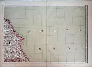
Yorkshire Coast. The Imperial Map of England & Wales.
Data di pubblicazione: 1868
Da: theoldmapman, Clevedon, SOMER, Regno Unito
Valutazione del venditore 5 su 5 stelle
Mappa
EUR 15,52
Spedizione EUR 7,53
Spedito da Regno Unito a U.S.A.Quantit�: 1 disponibili
Aggiungi al carrelloSingle sheet. Original antique map with original hand colouring of the county boundaries as issued. The Imperial Map of England & Wales according to the Ordnance Survey, with the latest additions; shewing clearly every feature of the country, railways and their stations, Roads, Canals, Rivers, Gentlemen's Seats, &c. &c. On the Scale of 4 Miles to an Inch. 69 x 49.5 cm.
-

For the Unity of All : Contributions to the Theological Dialogue Between East and West
Da: GreatBookPricesUK, Woodford Green, Regno Unito
Valutazione del venditore 5 su 5 stelle
EUR 49,30
Spedizione EUR 17,39
Spedito da Regno Unito a U.S.A.Quantit�: Pi� di 20 disponibili
Aggiungi al carrelloCondizione: As New. Unread book in perfect condition.
-

On Earth As in Heaven : Ecological Vision and Initiatives of Ecumenical Patriarch Bartholomew
Libro 3 di 26: Orthodox Christianity and Contemporary ThoughtDa: GreatBookPricesUK, Woodford Green, Regno Unito
Valutazione del venditore 5 su 5 stelle
EUR 49,45
Spedizione EUR 17,39
Spedito da Regno Unito a U.S.A.Quantit�: 1 disponibili
Aggiungi al carrelloCondizione: New.
-

Peripheral Vascular Diseases
Da: Romtrade Corp., STERLING HEIGHTS, MI, U.S.A.
Valutazione del venditore 5 su 5 stelle
Condizione: New. This is a Brand-new US Edition. This Item may be shipped from US or any other country as we have multiple locations worldwide.
-

On Earth As in Heaven : Ecological Vision and Initiatives of Ecumenical Patriarch Bartholomew
Libro 3 di 26: Orthodox Christianity and Contemporary ThoughtDa: GreatBookPricesUK, Woodford Green, Regno Unito
Valutazione del venditore 5 su 5 stelle
EUR 58,24
Spedizione EUR 17,39
Spedito da Regno Unito a U.S.A.Quantit�: 1 disponibili
Aggiungi al carrelloCondizione: As New. Unread book in perfect condition.
-
Allentown 1762-1987: A 225-Year History [Volume I]
Editore: Lehigh County Historical Society, Allentown, PA, 1987
Da: Saucony Book Shop, Kutztown, PA, U.S.A.
Valutazione del venditore 5 su 5 stelle
Prima edizione
Hardcover. Condizione: Fine. Condizione sovraccoperta: Very Good. 1st Edition. Dark blue cloth-effect paper covered boards, lettered in gold foil. As issued. Pictorial dust jacket is rubbed at corners and shows several mild creases and rubs, now in mylar. [x],584 pp., illus. w/ vintage b&w photographs, endpaper maps. Size: 4to - over 9�" - 12" tall. Book.
-
The Early Maps of Scotland With an Account of the Ordnance Survey.
Editore: Royal Scottish Geographical Society, 1936
Da: West Port Books, Edinburgh, Regno Unito
Valutazione del venditore 3 su 5 stelle

EUR 25,07
Spedizione EUR 26,66
Spedito da Regno Unito a U.S.A.Quantit�: 1 disponibili
Aggiungi al carrelloHardcover. Condizione: Near Fine. Revised and enlarged 2nd edition. Complete.
-
Allentown 1762-1987: A 225-Year History [Volume II]
Editore: Lehigh County Historical Society, Allentown, PA, 1987
Da: Saucony Book Shop, Kutztown, PA, U.S.A.
Valutazione del venditore 5 su 5 stelle
Prima edizione
Hardcover. Condizione: Fine. Condizione sovraccoperta: Fine. 1st Edition. Dark blue cloth-effect paper covered boards, lettered in gold foil. As issued. Pictorial dust jacket shows very slight edge rubbing, essentially as issued, now in mylar. [viii],663pp., illus. w/ vintage b&w photographs, endpaper maps. Size: 4to - over 9�" - 12" tall. Book.
-
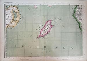
Isle of Man with parts of Northern Ireland & Cumberland. The Imperial Map of England & Wales.
Data di pubblicazione: 1868
Da: theoldmapman, Clevedon, SOMER, Regno Unito
Valutazione del venditore 5 su 5 stelle
Mappa
EUR 23,88
Spedizione EUR 7,53
Spedito da Regno Unito a U.S.A.Quantit�: 1 disponibili
Aggiungi al carrelloSingle sheet. Original antique map with original hand colouring of the county boundaries as issued. The Imperial Map of England & Wales according to the Ordnance Survey, with the latest additions; shewing clearly every feature of the country, railways and their stations, Roads, Canals, Rivers, Gentlemen's Seats, &c. &c. On the Scale of 4 Miles to an Inch. 69 x 49.5 cm.
-
The Early Maps of Scotland With an Account of the Ordnance Survey.
Editore: Edinburgh: Royal Scottish Geographical Society, 1936
Da: Richard Roberts Bookseller., KILMARNOCK, Regno Unito
Valutazione del venditore 5 su 5 stelle
EUR 38,81
Spedizione EUR 18,55
Spedito da Regno Unito a U.S.A.Quantit�: 1 disponibili
Aggiungi al carrello2nd. Edn. revised. Large 8vo. (25cm. tall x 15cm.). 171pp. With 8 folding maps in line and a further 11 single page maps. The original gilt lettered black cloth is damp wrinkled. The contents are clean, sound and very good with the maps in near perfect condition.
-
Allentown 1762-1987: A 225-Year History [Volume I]
Editore: Lehigh County Historical Society, Allentown, PA, 1987
Da: Saucony Book Shop, Kutztown, PA, U.S.A.
Valutazione del venditore 5 su 5 stelle
Prima edizione
Hardcover. Condizione: Fine. Condizione sovraccoperta: VG+. 1st Edition. Dark blue cloth-effect paper covered boards, lettered in gold foil. As issued. Pictorial dust jacket is mildly rubbed and creased at head of spine, with mild creasing along edges and minor rubbing to corners, now in mylar. [x],584 pp., illus. w/ vintage b&w photographs, endpaper maps. Size: 4to - over 9�" - 12" tall. Book.
-
South & West Wales. The Imperial Map of England & Wales.
Data di pubblicazione: 1868
Da: theoldmapman, Clevedon, SOMER, Regno Unito
Valutazione del venditore 5 su 5 stelle
Mappa
EUR 28,65
Spedizione EUR 7,53
Spedito da Regno Unito a U.S.A.Quantit�: 1 disponibili
Aggiungi al carrelloSingle sheet. Original antique map with original hand colouring of the county boundaries as issued. The Imperial Map of England & Wales according to the Ordnance Survey, with the latest additions; shewing clearly every feature of the country, railways and their stations, Roads, Canals, Rivers, Gentlemen's Seats, &c. &c. On the Scale of 4 Miles to an Inch. 69 x 49.5 cm.
-
Lincolnshire & North Norfolk. The Imperial Map of England & Wales.
Data di pubblicazione: 1868
Da: theoldmapman, Clevedon, SOMER, Regno Unito
Valutazione del venditore 5 su 5 stelle
Mappa
EUR 28,65
Spedizione EUR 7,53
Spedito da Regno Unito a U.S.A.Quantit�: 1 disponibili
Aggiungi al carrelloSingle sheet. Original antique map with original hand colouring of the county boundaries as issued. The Imperial Map of England & Wales according to the Ordnance Survey, with the latest additions; shewing clearly every feature of the country, railways and their stations, Roads, Canals, Rivers, Gentlemen's Seats, &c. &c. On the Scale of 4 Miles to an Inch. 69 x 49.5 cm.
-
Devon and the Bristol Channel; parts of Glamorganshire, Somerset and Cornwall. The Imperial Map of England & Wales.
Data di pubblicazione: 1868
Da: theoldmapman, Clevedon, SOMER, Regno Unito
Valutazione del venditore 5 su 5 stelle
Mappa
EUR 28,65
Spedizione EUR 7,53
Spedito da Regno Unito a U.S.A.Quantit�: 1 disponibili
Aggiungi al carrelloSingle sheet. Original antique map with original hand colouring of the county boundaries as issued. The Imperial Map of England & Wales according to the Ordnance Survey, with the latest additions; shewing clearly every feature of the country, railways and their stations, Roads, Canals, Rivers, Gentlemen's Seats, &c. &c. On the Scale of 4 Miles to an Inch. 69 x 49.5 cm.
-
Northumberland with parts of Durham & Cumberland. The Imperial Map of England & Wales.
Data di pubblicazione: 1868
Da: theoldmapman, Clevedon, SOMER, Regno Unito
Valutazione del venditore 5 su 5 stelle
Mappa
EUR 28,65
Spedizione EUR 7,53
Spedito da Regno Unito a U.S.A.Quantit�: 1 disponibili
Aggiungi al carrelloSingle sheet. Original antique map with original hand colouring of the county boundaries as issued. The Imperial Map of England & Wales according to the Ordnance Survey, with the latest additions; shewing clearly every feature of the country, railways and their stations, Roads, Canals, Rivers, Gentlemen's Seats, &c. &c. On the Scale of 4 Miles to an Inch. 69 x 49.5 cm.
-
Allentown 1762-1987: A 225-Year History [Volume I + II, Complete]
Editore: Lehigh County Historical Society, Allentown, PA, 1987
Da: Saucony Book Shop, Kutztown, PA, U.S.A.
Valutazione del venditore 5 su 5 stelle
Prima edizione
Hardcover. Condizione: Fine. Condizione sovraccoperta: Very Good. 1st Edition. Complete in two (2) volumes, uniformly bound in dark blue cloth, lettered in gold foil. As issued. Pictorial dust jackets VG with mild rubbing along edges and extremities, a few short closed edge tears, now in mylar. [x],584 + [viii],663 pp., illus. w/ b&w photographs, endpaper maps. Size: 4to - over 9" - 12" tall. Book.
-
North Wales. The Imperial Map of England & Wales.
Data di pubblicazione: 1868
Da: theoldmapman, Clevedon, SOMER, Regno Unito
Valutazione del venditore 5 su 5 stelle
Mappa
EUR 28,65
Spedizione EUR 7,53
Spedito da Regno Unito a U.S.A.Quantit�: 1 disponibili
Aggiungi al carrelloSingle sheet. Original antique map with original hand colouring of the county boundaries as issued. The Imperial Map of England & Wales according to the Ordnance Survey, with the latest additions; shewing clearly every feature of the country, railways and their stations, Roads, Canals, Rivers, Gentlemen's Seats, &c. &c. On the Scale of 4 Miles to an Inch. 69 x 49.5 cm.