
Importo totale (1 articolo articoli):
Destinazione ordine:

beers s n (26 risultati)
Vai alla pagina principale dei risultati di ricerca
Filtri di ricerca
Tipo di articolo
- Tutti i tipi di prodotto
- Libri (26)
- Riviste e Giornali (Nessun altro risultato corrispondente a questo perfezionamento)
- Fumetti (Nessun altro risultato corrispondente a questo perfezionamento)
- Spartiti (Nessun altro risultato corrispondente a questo perfezionamento)
- Arte, Stampe e Poster (Nessun altro risultato corrispondente a questo perfezionamento)
- Fotografie (Nessun altro risultato corrispondente a questo perfezionamento)
- Mappe (Nessun altro risultato corrispondente a questo perfezionamento)
- Manoscritti e Collezionismo cartaceo (Nessun altro risultato corrispondente a questo perfezionamento)
Condizioni Maggiori informazioni
Legatura
Ulteriori caratteristiche
- Prima ed. (4)
- Copia autograf. (Nessun altro risultato corrispondente a questo perfezionamento)
- Sovracoperta (Nessun altro risultato corrispondente a questo perfezionamento)
- Con foto (15)
- Non Print on Demand (26)
Lingua (2)
Spedizione gratuita
Paese del venditore
Valutazione venditore
-
Merck Manual of Women's and Men's Health
Da: GreatBookPrices, Columbia, MD, U.S.A.
Valutazione del venditore 5 su 5 stelle

EUR 21,08
Spedizione EUR 2,29
Spedito in U.S.A.Quantit�: Pi� di 20 disponibili
Aggiungi al carrelloCondizione: New.
-
Merck Manual of Women's and Men's Health
Da: GreatBookPrices, Columbia, MD, U.S.A.
Valutazione del venditore 5 su 5 stelle
EUR 23,30
Spedizione EUR 2,29
Spedito in U.S.A.Quantit�: Pi� di 20 disponibili
Aggiungi al carrelloCondizione: As New. Unread book in perfect condition.
-
Atlas of Westmoreland County Pennsylvania 1867
Editore: McClain Printing Company, 1981
Da: Newhouse Books, Washington Court House, OH, U.S.A.
Valutazione del venditore 5 su 5 stelle
Soft cover. Condizione: Very Good. One thousand copies printed Spring 1981. This is copy number 863 "Price: $25.00, postpaid" (1981) Dimensions: 15 X 15 1/2 in. 71 pages plus index.
-

Life Application Study Bible-NASB
Da: Firefly Bookstore, Kutztown, PA, U.S.A.
Valutazione del venditore 5 su 5 stelle
Bonded Leather. Condizione: Used Very Good. No Jacket. Light wear to cover, slightly bumped corners, pages clean and unmarked. Spine has a curve, but the binding is intact. Gold on the page edges has some wear and scratches. Firefly sells new and used books through our store front. We try to add a detailed description to as many titles as possible. If you have questions regarding this title, please contact us. Photos available on request.
-

Merck Manual of Women's and Men's Health
Da: GreatBookPricesUK, Woodford Green, Regno Unito
Valutazione del venditore 5 su 5 stelle
EUR 26,53
Spedizione EUR 17,39
Spedito da Regno Unito a U.S.A.Quantit�: Pi� di 20 disponibili
Aggiungi al carrelloCondizione: New.
-
Merck Manual of Women's and Men's Health
Da: GreatBookPricesUK, Woodford Green, Regno Unito
Valutazione del venditore 5 su 5 stelle
EUR 29,46
Spedizione EUR 17,39
Spedito da Regno Unito a U.S.A.Quantit�: Pi� di 20 disponibili
Aggiungi al carrelloCondizione: As New. Unread book in perfect condition.
-

New topographical atlas of Saratoga County, New York. From the actual surveys by S.N. and D.G. Beers and assistants
Editore: Rexford, Howard Becker, [circa, 1960
Da: Hammer Mountain Book Halls, ABAA, Schenectady, NY, U.S.A.
Membro dell'associazione: ABAA ILAB
Valutazione del venditore 5 su 5 stelle
Softcover. Front cover sun-faded at bottom edge, with several small spots; corners slightly bumped, slightly affecting pages; 1-inch split at bottom of taped binding; otherwise very good condition. An uncredited reprint issued circa 1960 by Howard Becker of Rexford, New York, and bound in his characteristic blue stiff covers. ]. 77p. Quarto.
-
New Topographical Atlas of Saratoga Co. (County), New York
Data di pubblicazione: 1969
Da: Muddy Turtle Books, Fernandina Beach, FL, U.S.A.
Valutazione del venditore 5 su 5 stelle
Facsimile Edition. This is an exact copy of the original atlas published by Stone and Stewart in 1866. Pink stain on small part of front cover, One tear at top of cover and first page (title page). Otherwise all the maps, illustrations and county information are in fine con [PC-BOT] We provide PROTECTIVE packaging. Photos of our books are always available upon request. SELLING USED AND RARE BOOKS ON ABE SINCE 1997 AND IN OUR STORE IN THE BERKSHIRES FROM 1987 TO 2015.
-
Atlas of Westmoreland County, Pennsylvania (reprint of the 1867 Beers/Pomeroy Atlas)
Editore: McClain Printing, 1981
Da: Berryville Old Book Shop, Berryville, VA, U.S.A.
Valutazione del venditore 5 su 5 stelle
Spiral bound. Reprint. 72 pgs + 20 pgs index. 292 of 1,000 copies. Very good oversized spiral-bound copy. No international shipping due to size. (shop above Art).
-

Trace Elements in Coal and Coal Combustion Residues: 5 (Advances in Trace Substances Research)
Libro 1 di 2: Advances in Trace Substances ResearchDa: Chiron Media, Wallingford, Regno Unito
Valutazione del venditore 5 su 5 stelle
EUR 334,33
Spedizione EUR 17,96
Spedito da Regno Unito a U.S.A.Quantit�: 5 disponibili
Aggiungi al carrelloHardcover. Condizione: New.
-
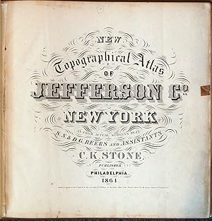
New Topographical Atlas of Jefferson Co., New York: From Actual Surveys
Lingua: Inglese
Editore: C. K. Stone, Philadelphia, PA, 1864
Hardcover. Condizione: Very Good. No Jacket. The volume measures 16 1/2 x 16 1/2 inches. Includes 37 fully colored maps and one illustration The cover shows some edgewear with fading and rubbing. The binding is sound. The endpage and title page show edgewear with age toning. Maps are in excellent condition.
-
Topographical Atlas of Schoharie Co. New York
Editore: Martin Wehle, Churchville, NY, 1974
Da: Dennis Holzman Antiques, Cohoes, NY, U.S.A.
Valutazione del venditore 5 su 5 stelle
Hardcover. Condizione: Very Good. Condizione sovraccoperta: No Dust Jacket. Reprint Edition. Size: 15 3/4" x 13 1/2". Text body is clean, and free from previous owner annotation, underlining and highlighting. Gilt-stamped beige cloth over boards, includes 63 maps. This atlas is number 131 of an edition of 300 and is signed by the publisher, Martin Wehle. Covers rubbed, a few scratches, clean interior. Quantity Available: 1. Shipped Weight: 4 lbs 0 oz. Category: Geography & Maps; Pictures of this item not already displayed here available upon request. Inventory No: 015654.
-
MAP OF THE VICINITY OF PHILADELPHIA From Actual Surveys By D.J. Lake and S.N.Beers
Lingua: Inglese
Editore: J.E. Gillette & Co., Philadelphia, 1861
Da: THOMAS RARE BOOKS, Yaxley, SUFFOLK, Regno Unito
Valutazione del venditore 4 su 5 stelle

Prima edizione
EUR 3.283,50
Spedizione EUR 17,39
Spedito da Regno Unito a U.S.A.Quantit�: 1 disponibili
Aggiungi al carrelloprinted Map. Condizione: Fine. 1st Edition. A very rare large folding map of Philadelphia divided into 36 sections [each 22x23 cms] and laid on a single linen sheet, 132x 138cms [52x54 inches]. Hand coloured. Enclosed with marbled paper covers. Only one copy traced. [City of Philadelphia Parks and Recreation Historic Archives]. No copy traced at auction. PLEASE EMAIL FOR PHOTOS.
-
New Topographical Atlas of Schoharie County, New York, from Actual Surveys by S. N. & D. G. Beers and Assistants
Editore: Martin Wehle, Churchville, NY, 1974
Da: Saucony Book Shop, Kutztown, PA, U.S.A.
Valutazione del venditore 5 su 5 stelle
Cloth. Condizione: Very Good. Condizione sovraccoperta: Not Issued. Facsimile Reprint Edition. Dark blue cloth, lettered in gold foil. Facsimile reprint of original 1866 edition, offset printing by B & E Printers, binding by Rochester Book Bindery. Modest shelf wear, a few light surface marks to cloth, light rubbing to back cover. Two approx. 1/2" closed tears through cloth and underboard along bottom rear edge near joint, with some fraying to cloth at heel of spine. Light foxing to endsheets and main title, text block edges. Firm binding, otherwise clean interior. Scarce. Includes towns of Blenheim, Broome, Carlisle, Cobleskill, Conesville, Esperance, Fulton, Gilboa, Jefferson, Middleburgh, Richmondville, Schoharie, Seward, Sharon, Summit, Wright, etc. Size: Elephant Folio - over 15" - 23" tall. Book.
-
New Topographical Atlas of Jefferson Co., New York
Editore: New York, New York, 1864
Da: High Ridge Books, Inc. - ABAA, South Deerfield, MA, U.S.A.
Membro dell'associazione: ABAA ESA ILAB SNEAB
Valutazione del venditore 5 su 5 stelle
Modern 1/4 leather with buckram. Internally fine, but this atlas is lacking the county map, which is listed on the contents leaf as the last map in the atlas. An otherwise excellent copy of one of the earliest American county atlases, the first by the Beers family who would become noted for this cartographic form. Ristow, p. 404, specifically mentions this atlas as the first for Daniel and Silas Beers. [84] p., 37 fully colored maps, one illustration. LeGear L2452.
-
New topographical atlas of St. Lawrence County, N.Y. : from actual surveys
Editore: Philadelphia : Stone & Stewart, 1865
Da: Sequitur Books, Boonsboro, MD, U.S.A.
Membro dell'associazione: IOBA
Valutazione del venditore 5 su 5 stelle
Prima edizione
Hardcover. Condizione: Fair. First Edition. Square folio, 39 x 41 cm. 92 pages : chiefly hand-colored lithographic maps. Collated, complete, 41 maps. Bound in publisher's marbled paste-paper boards over cloth spine. Lacking spine, boards detached. Edgewear to cover. Spotting, marginal dampstaining. This is an early county atlas made in the second year of the Beers family county atlas production. Engraved by Jas. McGuigan. This is an oversized or heavy book, which requires additional postage for international delivery outside the US.
-
NEW TOPOGRAPHICAL ATLAS OF ST. LAWRENCE CO., NEW YORK
Editore: Stone & Stewart, Philadelphia, PA, 1865
Da: Riverow Bookshop, Owego, NY, U.S.A.
Membro dell'associazione: ABAA ILAB
Valutazione del venditore 5 su 5 stelle
Cloth/Boards. Condizione: G/No Dustjacket. Black & White Illustrations (illustratore). Philadelphia, PA: Stone & Stewart. G/No Dustjacket. 1865. . Cloth/Boards. pasted in plate on flyleaf . Folio, 92 pp., rubbed, bumped, cloth spine splitting, frayed, hinges broken, bookplate, page foxing & toning, corners chipped, stains .
-
Axles and axle-boxes. being patent number 3652 published 18 September 1876
Editore: London Eyre and Spottiswood HMSO printed c, 1876
Prima edizione
EUR 119,40
Spedizione EUR 4,75
Spedito da Regno Unito a U.S.A.Quantit�: 1 disponibili
Aggiungi al carrellono binding. Condizione: good. First Edition. Original Printed patent disbound About 27cm by 18cm some wear and tear due to the disbinding.
-
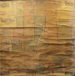
MAP OF ONTARIO COUNTY NEW YORK 1859 [Wall Map]
Editore: Dawson, Philadelphia, PA, 1859
Da: Riverow Bookshop, Owego, NY, U.S.A.
Membro dell'associazione: ABAA ILAB
Valutazione del venditore 5 su 5 stelle
WallChart. Condizione: Good/NO DUSTJACKET. Philadelphia, PA: Dawson. Good/NO DUSTJACKET. 1859. WallChart. 64 X 60 inches including roller slats. One little hole. Major staining on right side .
-
Map of Ontario County, New York
Editore: Philadelphia, Philadelphia, 1859
Da: High Ridge Books, Inc. - ABAA, South Deerfield, MA, U.S.A.
Membro dell'associazione: ABAA ESA ILAB SNEAB
Valutazione del venditore 5 su 5 stelle
Fair condition, general wear overall, vertical crack from bottom at center, small chips, with some loss, from the towns of Manchester and Hopewell and two other small chips near the top. Water stain at bottom left corner. Lacks bottom rod. Wall map with 9 inset views of buildings and 28 inset plans of towns and villages. This county in the Finger Lakes region includes the Towns of Geneva and Canandaigua. Land owners identified on both the large map and the inset plans. Published by A. R. Z. Dawson. Phillips p. 640.
-
NEW TOPOGRAPHICAL ATLAS OF BROOME COUNTY, NEW YORK .
Editore: Stone & Stewart, Publishers, Philadelphia, PA, 1866
Da: Riverow Bookshop, Owego, NY, U.S.A.
Membro dell'associazione: ABAA ILAB
Valutazione del venditore 5 su 5 stelle
BoardBook. Condizione: Good +/NO DUSTJACKET. Color Maps (illustratore). Philadelphia, PA: Stone & Stewart, Publishers. Good +/NO DUSTJACKET. 1866. BoardBook. 16.5 X 14 inches, 34 leaves with maps and views . Folio, Hinges still tight, light foxing spots .
-
MAP OF THE COUNTIES OF CHENANGO AND CORTLAND, NEW YORK.
Editore: Pomeroy and Treat, Philadelphia, PA, 1863
Da: Riverow Bookshop, Owego, NY, U.S.A.
Membro dell'associazione: ABAA ILAB
Valutazione del venditore 5 su 5 stelle
Condizione: VG/No Dustjacket. Philadelphia, PA: Pomeroy and Treat. VG/No Dustjacket. 1863. 66" x 64" plus rollers. Nice and clean with solid linen backing. Less than .1 % missing plus a few minor tears and stains. .
-
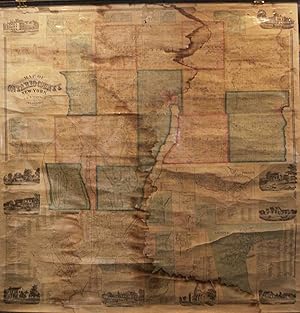
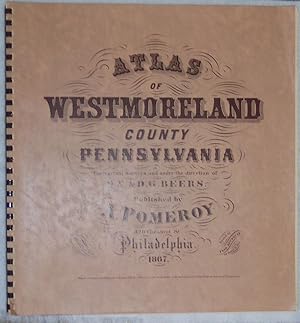
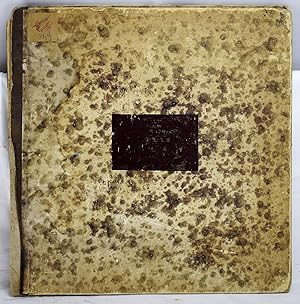
Atlas of Westmoreland County, Pennsylvania from actual Surveys [.]
Editore: A. Pomeroy, Philadelphia, 1867
Da: Lorne Bair Rare Books, ABAA, Winchester, VA, U.S.A.
Membro dell'associazione: ABAA ILAB IOBA
Valutazione del venditore 5 su 5 stelle
Prima edizione
First Edition. First printing. Folio (40cm x 37cm; ca 16" x 14-1/2"). Original marbled paper-covered boards, re-spined and recornered to style; new endpapers; early owner's inserted stenciled half-title ("James Mathews / Atlas / April 14 1868"); 72pp. Leaves are printed rectos-only, comprising title-page, 64 hand-colored maps (two folding), a table of distances, and one sheet of statistical & demographic data. A complete, well-preserved copy. The inserted hand-stenciled leaf is somewhat soiled at margins; maps generally clean and fresh with occasional mild marginal foxing. Hand-coloring remains clear and vivid. An excellent Western Pennsylvania atlas, showing townships, railroads, coal seams, etc. in the years immediately following the Civil War. Farmsteads and major houses are identified by resident; business directories are included for most municipalities, even the smallest villages. Uncommon, especially in such attractive condition.
-

Map of Columbia Co., New York
Editore: Philadelphia, Philadelphia, 1858
Da: High Ridge Books, Inc. - ABAA, South Deerfield, MA, U.S.A.
Membro dell'associazione: ABAA ESA ILAB SNEAB
Valutazione del venditore 5 su 5 stelle
Large wall map in fair to good condition, scattered light chipping and soiling, torn at bottom left corner with slight loss to view. 22 inset maps of towns and villages and 9 inset views of buildings. Columbia County is south of Albany between the Hudson River and Massachusetts. Not in Phillips.
-
Map of Ontario County, New York
Editore: Philadelphia, Philadelphia, 1859
Da: High Ridge Books, Inc. - ABAA, South Deerfield, MA, U.S.A.
Membro dell'associazione: ABAA ESA ILAB SNEAB
Valutazione del venditore 5 su 5 stelle
Generally good to very good condition, with a water stain down the center of the map, chipping at the top with loss to inset plan of Flint Creek. With 9 inset views of buildings and 28 inset plans of towns and villages. This county in the Finger Lakes region includes the Towns of Geneva and Canandaigua. Land owners identified on both the large map and the inset plans. Published by A. R. Z. Dawson. Phillips p. 640.
-
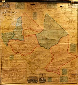
Map of Cumberland County, New Jersey
Editore: Philadelphia, Philadelphia, 1862
Da: High Ridge Books, Inc. - ABAA, South Deerfield, MA, U.S.A.
Membro dell'associazione: ABAA ESA ILAB SNEAB
Valutazione del venditore 5 su 5 stelle
Wall map in very good condition to fine condition. There are small holes, with some loss, in the inset plans of Vineland and Roadstown at the top of the map. Aside from those blemishes, the map is in fine condition. Original linen backing. Full color by town. Land owners identified. 18 inset maps of towns, 4 views of buildings. The first detailed map of this rural southwestern New Jersey county, Phillips p. 256.


![Immagine del venditore per MAP OF ONTARIO COUNTY NEW YORK 1859 [Wall Map] venduto da Riverow Bookshop](https://pictures.abebooks.com/inventory/md/md31843547100.jpg)

![Immagine del venditore per Atlas of Westmoreland County, Pennsylvania from actual Surveys [.] venduto da Lorne Bair Rare Books, ABAA](https://pictures.abebooks.com/inventory/md/md32407516418.jpg)