
Importo totale (1 articolo articoli):
Destinazione ordine:

bellin r (14 risultati)
Vai alla pagina principale dei risultati di ricerca
Filtri di ricerca
Tipo di articolo
- Tutti i tipi di prodotto
- Libri (13)
- Riviste e Giornali (Nessun altro risultato corrispondente a questo perfezionamento)
- Fumetti (Nessun altro risultato corrispondente a questo perfezionamento)
- Spartiti (Nessun altro risultato corrispondente a questo perfezionamento)
- Arte, Stampe e Poster (Nessun altro risultato corrispondente a questo perfezionamento)
- Fotografie (Nessun altro risultato corrispondente a questo perfezionamento)
- Mappe (1)
- Manoscritti e Collezionismo cartaceo (Nessun altro risultato corrispondente a questo perfezionamento)
Condizioni Maggiori informazioni
- Nuovo (3)
- Come nuovo, Ottimo o Quasi ottimo (3)
- Molto buono o Buono (5)
- Discreto o Mediocre (Nessun altro risultato corrispondente a questo perfezionamento)
- Come descritto (3)
Legatura
- Tutte
- Rilegato (Nessun altro risultato corrispondente a questo perfezionamento)
- Brossura (6)
Ulteriori caratteristiche
- Prima ed. (Nessun altro risultato corrispondente a questo perfezionamento)
- Copia autograf. (Nessun altro risultato corrispondente a questo perfezionamento)
- Sovracoperta (Nessun altro risultato corrispondente a questo perfezionamento)
- Con foto (8)
- Non Print on Demand (14)
Lingua (2)
Spedizione gratuita
- Spedizione gratuita in U.S.A. (Nessun altro risultato corrispondente a questo perfezionamento)
Paese del venditore
Valutazione venditore
-

N - 33 - 77 - C- c .Uecerm�nde. 01.3.13.33.077.033. Vertrauliche Verschlu�sache! Topographische Karte DDR 1:25000 , Stand 1987, Ausgabe 1989. 45 x 42 cm. Hergestellt und herausgegeben: Ministerium f�r Nationale Verteidigung Milit�rtopographischer Dienst. Originale mehrfarbige Karte.
Da: Graphikantiquariat Martin Koenitz, Leipzig, SACHS, Germania
Valutazione del venditore 5 su 5 stelle

EUR 8,00
Spedizione EUR 9,95
Spedito da Germania a U.S.A.Quantit�: 1 disponibili
Aggiungi al carrelloGuter verlagsfrischer Erhaltungszustand, ungefaltet. ACHTUNG: VERSANDKOSTEN bei UNGEFALTETEM ZUSTAND 5 (!!!), gefaltet nur 2,30 - abebooks / ZVAB geben nur 2,30 an! Das topographische Kartenwerk "Ausgabe Staat" (AS) im Ma�stab 1 : 25 000 wurde in der DDR in die Kategorie von Staatsgeheimnissen (Vertrauliche Verschlu�sache, VVS) eingeordnet und durfte nur von Befugten der Bewaffneten Organe und der Partei- und Staatsf�hrung genutzt werden. In diesen Karten waren auch milit�rische Anlagen lagerichtig und vollst�ndig verzeichnet. Das Kartenwerk wurde bis 1989 nach den von den Teilnehmerstaaten der Warschauer Vertragsorganisation vereinbarten Grunds�tzen bearbeitet. Die vorliegende TK25 Ausgabe Staat (DDR) zeigt die Erdoberfl�che Ostdeutschlands (DDR) in den Jahren 1976 bis 1989 und bildet somit ein wichtiges Element in der Reihe der historischen Kartenwerke. F�r ausgew�hlte St�dte wurden anstelle der "einfachen" topographischen Karten topographische Stadtpl�ne herausgegeben. In diesen Stadtpl�nen sind zus�tzlich die Stra�ennamen dargestellt und verschiedene Objekte, z. B. �ffentliche Geb�ude, hervorgehoben. Die Bezeichnung "Ausgabe Staat" (AS) ist im Gegensatz zur "Ausgabe f�r die Volkswirtschaft" (AV) nicht auf den Karten aufgedruckt. Diese sind aber an dem Aufdruck "Vertrauliche Verschlu�sache!" erkennbar. Die Ausgabe f�r die Volkswirtschaft war lediglich "Nur f�r den Dienstgebrauch". Neben den verschiedenen Karteninhalten (siehe Kartenausschnitte unten: AS mit Flughafen, AV ohne) unterschieden sich die beiden Kartenwerke auch in den geod�tischen Grundlagen. Die Ausgabe Staat (AS) bezieht sich auf das Referenzellipsoid von Krassowski im 6�-Streifensystem (Gau�-Kr�ger-System), die Ausgabe f�r die Volkswirtschaft (AV) auf das Referenzellipsoid von Bessel im 3�-Streifensystem (Gau�-Kr�ger-System). Sprache: Deutsch.
-

Heidegger and Music
Libro 27 di 31: New Heidegger ResearchDa: GreatBookPrices, Columbia, MD, U.S.A.
Valutazione del venditore 5 su 5 stelle
EUR 50,09
Spedizione EUR 2,27
Spedito in U.S.A.Quantit�: Pi� di 20 disponibili
Aggiungi al carrelloCondizione: As New. Unread book in perfect condition.
-

Heidegger and Music
Libro 27 di 31: New Heidegger ResearchDa: GreatBookPrices, Columbia, MD, U.S.A.
Valutazione del venditore 5 su 5 stelle
EUR 50,85
Spedizione EUR 2,27
Spedito in U.S.A.Quantit�: Pi� di 20 disponibili
Aggiungi al carrelloCondizione: New.
-
TEST YOUR POSITIONAL PLAY
Da: Rare Book Exchange, Mastic Beach, NY, U.S.A.
Valutazione del venditore 2 su 5 stelle

1015545 1985 FIRST EDITION 192PP. ILLUSTRATED. SOFT COVER GOOD CONDITION. STE 538.
-
Heidegger and Music
Libro 27 di 31: New Heidegger ResearchDa: GreatBookPricesUK, Woodford Green, Regno Unito
Valutazione del venditore 5 su 5 stelle
EUR 49,52
Spedizione EUR 17,35
Spedito da Regno Unito a U.S.A.Quantit�: Pi� di 20 disponibili
Aggiungi al carrelloCondizione: New.
-
Heidegger and Music
Libro 27 di 31: New Heidegger ResearchDa: GreatBookPricesUK, Woodford Green, Regno Unito
Valutazione del venditore 5 su 5 stelle
EUR 54,08
Spedizione EUR 17,35
Spedito da Regno Unito a U.S.A.Quantit�: Pi� di 20 disponibili
Aggiungi al carrelloCondizione: As New. Unread book in perfect condition.
-

TRIANGULATION
Libro 5 di 13: Triangulation AnthologiesLingua: Inglese
Editore: Amazon Digital Services LLC - KDP Print US, 2020
ISBN 10: 0974323144 ISBN 13: 9780974323145
EUR 27,86
Spedizione EUR 61,57
Spedito da Germania a U.S.A.Quantit�: 2 disponibili
Aggiungi al carrelloTaschenbuch. Condizione: Neu. Kireeva, Katherine (illustratore). Neuware.
-

Triangulation: Extinction (Triangulation Anthologies)
Libro 5 di 13: Triangulation AnthologiesDa: Sell Books, Elland, YORKS, Regno Unito
Valutazione del venditore 5 su 5 stelle
EUR 1.057,65
Spedizione EUR 14,05
Spedito da Regno Unito a U.S.A.Quantit�: 1 disponibili
Aggiungi al carrellopaperback. Condizione: Good. Kireeva, Katherine (illustratore). Our good condition books are generally good for reading but not for gifting or collecting. They could have imperfections such as creasing, fanning, inscriptions, margin notes, yellowing, staining on edge or cover or pages, bumps, scuffs, etc etc (sometimes multiple of these). It's a wide category that encompasses anything that isn't almost-new down to anything that is slightly better than poor. We would NOT recommend gifting Good books - these should be considered reading copies. Our books are dispatched from a Yorkshire former cotton mill. We list via barcode/ISBN so please note that the images are stock images and may not be the exact copy you receive, furthermore the details about edition and year might not be accurate as many publishers reuse the same ISBN for multiple editions and as we simply scan a barcode or enter an ISBN we do not check the validity of the edition data when listing. If you're looking for an exact edition please don't order (at least not without checking with us first, although we don't always have time to check). We aim to dispatch prompty, the service used will depend on order value and book size. We can ship to most countries, see our shipping policies. Payment is via Abe only.
-

Carte de la coste occidentale D'Afrique, depuis le XI.e degr� de latitude meridionale jusqu'au Cap de Bonne Esperance. Tir�e de la carte Francoise de l'Ocean Occidental publi�e en 1738 par ordre de Mgr. le Comte de Maurepas. Kaart van de Westkust van Afrika, van den XI.e graad Zuiderbreedte tot aan de Kaap de Goede-Hoop.
Editore: [La Haye, Pierre de Hondt, 1747]., 1747
Da: Charbo's Antiquariaat, Amsterdam, Paesi Bassi
Membro dell'associazione: ILAB NVVA
Valutazione del venditore 5 su 5 stelle
EUR 39,00
Spedizione EUR 37,50
Spedito da Paesi Bassi a U.S.A.Quantit�: 1 disponibili
Aggiungi al carrelloCondizione: Good. 25.5 x 26 cm. (2 folds; lower edge frayed/chipped, part of lower right corner replaced with blank paper, with small loss of the engraving; repair with browned paper strip to left margin). * Uncoloured engraved map from Antoine F. Pr�vost d'Exiles, Histoire g�n�rale des voyages. Vol. 1. La Haye, 1747 (4to ed.).
-

Carte de la coste orientale d'Afrique depuis le Cap de Bonne Esperance jusqu'au Cap del Gada, tir�e de la carte francoise de l'Ocean Oriental, publie� en 1740 par ordre de Mgr. le Comte de Maurepas. Kaart van de Oostkust van Afrika, van Kaap de Goede-Hoop tot aan Kaap del Gada.
Editore: [La Haye, Pierre de Hondt, 1749]., 1749
Da: Charbo's Antiquariaat, Amsterdam, Paesi Bassi
Membro dell'associazione: ILAB NVVA
Valutazione del venditore 5 su 5 stelle
EUR 44,00
Spedizione EUR 37,50
Spedito da Paesi Bassi a U.S.A.Quantit�: 1 disponibili
Aggiungi al carrelloCondizione: Good. 25.5 x 22 cm. (2 folds; repair with browned paper strip to top of right margin). * Uncoloured engraved map from Antoine F. Pr�vost d'Exiles, Histoire g�n�rale des voyages. La Haye, 1749 (4to ed.).
-
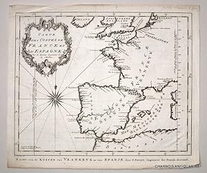
Carte des costes de France et d'Espagne. Kaart van de kusten van Vrankryk en van Spanje.
Editore: [La Haye, Pierre de Hondt, 1748]., 1748
Da: Charbo's Antiquariaat, Amsterdam, Paesi Bassi
Membro dell'associazione: ILAB NVVA
Valutazione del venditore 5 su 5 stelle
EUR 50,00
Spedizione EUR 37,50
Spedito da Paesi Bassi a U.S.A.Quantit�: 1 disponibili
Aggiungi al carrelloCondizione: VG. 23 x 27 cm. (Vertical fold). * Uncoloured engraved map from Antoine F. Pr�vost d'Exiles, Histoire g�n�rale des voyages. Vol. 6. La Haye, 1748 (4to ed.).
-

Carte des isles de Comore Johanna ou Anjouan Mohilla ou Moaly et Mayote. Dress�e sur les remarques des navigateurs. Kaart van de eilanden Komoro, Anjuan, Moelia, en Mayotta.
Editore: [La Haye, Pierre de Hondt, 1749]., 1749
Da: Charbo's Antiquariaat, Amsterdam, Paesi Bassi
Membro dell'associazione: ILAB NVVA
Valutazione del venditore 5 su 5 stelle
EUR 66,00
Spedizione EUR 37,50
Spedito da Paesi Bassi a U.S.A.Quantit�: 1 disponibili
Aggiungi al carrelloCondizione: Fine. 22 x 24.5 cm. (Vertical fold). * Uncoloured engraved map from Antoine F. Pr�vost d'Exiles, Histoire g�n�rale des voyages. La Haye, 1749. (4to ed.).
-

Suite de la coste de Guin�e, depuis le Cap de Palme jusqu'au Cap des Trois Pointes. Vervolg van de kust van Guin�e van Kaap das Palmas tot aan Kaap Tres Puntas.
Editore: [La Haye, Pierre de Hondt, 1746]., 1746
Da: Charbo's Antiquariaat, Amsterdam, Paesi Bassi
Membro dell'associazione: ILAB NVVA
Valutazione del venditore 5 su 5 stelle
EUR 66,00
Spedizione EUR 37,50
Spedito da Paesi Bassi a U.S.A.Quantit�: 1 disponibili
Aggiungi al carrelloCondizione: VG. 21 x 28 cm. (Vertical fold). * Uncoloured engraved map of the coast of Guinea, West Africa, from Antoine F. Pr�vost d'Exiles, Histoire g�n�rale des voyages. Vol. 3. La Haye, 1747 (4to ed.).
-

Plan de la Ville et du Port de Nangasaki Grond tekening van de stad en de Haven van Nangasaki
Editore: [1758?]., 1758
Da: Daniel Crouch Rare Books Ltd, London, Regno Unito
Membro dell'associazione: ABA ILAB PBFA
Valutazione del venditore 4 su 5 stelle

Mappa
EUR 178,66
Spedizione EUR 23,13
Spedito da Regno Unito a U.S.A.Quantit�: 1 disponibili
Aggiungi al carrelloDutch plan of Nagasaki Engraved plan with original hand colour. A plan of Nagasaki from a Dutch edition of the Abb� Pr�vost's travel book, the 'Histoire Generale des Voyages'. Pr�vost's work was an expansion of Thomas Astley's 'Voyages and Travels' compiled by Astley from sources including John Atkins, Theodor de Bry and Jean-Baptiste Lavat. The first seven volumes of Astley's work were translated into French by the Abb� Antoine Fran�ois Pr�vost (1697-1763). As well as translating Astley's work, Pr�vost added a general history of discoveries and colonisation to his own lifetime, as well as an overview of the historical sources he used. It was first published in Paris in 15 volumes (the present edition) from 1746-1761. The maps for the 'Histoire' were produced by Jacques Nicolas Bellin. They were re-engraved by Jacob van der Schley for the Dutch editions of the work.
