
Importo totale (1 articolo articoli):
Destinazione ordine:

cancelled (12 risultati)
Vai alla pagina principale dei risultati di ricerca
Filtri di ricerca
Tipo di articolo
- Tutti i tipi di prodotto
- Libri (11)
- Riviste e Giornali (Nessun altro risultato corrispondente a questo perfezionamento)
- Fumetti (Nessun altro risultato corrispondente a questo perfezionamento)
- Spartiti (Nessun altro risultato corrispondente a questo perfezionamento)
- Arte, Stampe e Poster (Nessun altro risultato corrispondente a questo perfezionamento)
- Fotografie (Nessun altro risultato corrispondente a questo perfezionamento)
- Mappe (1)
- Manoscritti e Collezionismo cartaceo (Nessun altro risultato corrispondente a questo perfezionamento)
Condizioni Maggiori informazioni
- Nuovo (4)
- Come nuovo, Ottimo o Quasi ottimo (Nessun altro risultato corrispondente a questo perfezionamento)
- Molto buono o Buono (6)
- Discreto o Mediocre (Nessun altro risultato corrispondente a questo perfezionamento)
- Come descritto (2)
Legatura
Ulteriori caratteristiche
- Prima ed. (5)
- Copia autograf. (Nessun altro risultato corrispondente a questo perfezionamento)
- Sovracoperta (Nessun altro risultato corrispondente a questo perfezionamento)
- Con foto (9)
- Non Print on Demand (12)
Lingua (2)
Spedizione gratuita
- Spedizione gratuita in U.S.A. (Nessun altro risultato corrispondente a questo perfezionamento)
Paese del venditore
Valutazione venditore
-
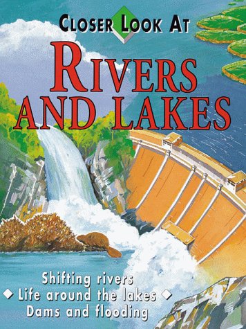
Rivers And Lakes (Closer Look at)
Da: Library House Internet Sales, Grand Rapids, OH, U.S.A.
Valutazione del venditore 5 su 5 stelle

Hardcover. Condizione: Good. No Jacket. This new title in the Closer Look At series for young readers explores the ways in which rivers and lakes have shaped our landscape and how they provide fresh water for human, animal, and plant life. Piece(s) of the spine missing. Former library book. Please note the image in this listing is a stock photo and may not match the covers of the actual item. Ex-Library.
-

CANCELLED
Da: Ria Christie Collections, Uxbridge, Regno Unito
Valutazione del venditore 5 su 5 stelle
EUR 14,92
Spedizione EUR 13,99
Spedito da Regno Unito a U.S.A.Quantit�: Pi� di 20 disponibili
Aggiungi al carrelloCondizione: New. In.
-
EUR 18,83
Spedizione EUR 14,95
Spedito da Paesi Bassi a U.S.A.Quantit�: 1 disponibili
Aggiungi al carrelloCondizione: Very good.
-

Scott #986, 1949, First Day ISSUE Cover WITH 4 Cancelled Poe 3 CENT Stamps, 10/7/49 Richmond Block Edgar Allan Poe, on front of ADDRESSED Envelope, This is a Block on a Richmond, VA First Day Cover. Issued on October 7, 1949, the cover is in mint condition. In Commemo
Editore: USPS, 1949
Da: Bluff Park Rare Books, LONG BEACH, CA, U.S.A.
Membro dell'associazione: IOBA
Valutazione del venditore 4 su 5 stelle

Prima edizione
Soft cover. Condizione: Very Good. No Jacket. 1st Edition. In Commemoration of 100th Anniversary of death of Edgar Allan Poe, Scott #986, First Day Cover 1949, First Day ISSUE Cover WITH 4 Cancelled Poe 3 CENT Stamps on front of ADDRESSED Envelope, 10/7/49 Richmond Block Edgar Allen Poe.
-

The Passing of Temporal Well-Being
Libro 4 di 25: Routledge Focus on PhilosophyLingua: Inglese
Editore: Taylor & Francis Ltd Dez 2020, 2020
ISBN 10: 0367735156 ISBN 13: 9780367735159
EUR 45,85
Spedizione EUR 60,65
Spedito da Germania a U.S.A.Quantit�: 2 disponibili
Aggiungi al carrelloTaschenbuch. Condizione: Neu. Neuware - The philosophical study of well-being concerns what makes lives good for their subjects. It is now standard among philosophers to distinguish between two kinds of well-being:
-

Lectures in Geochemistry
Lingua: Inglese
Editore: Taylor & Francis Ltd Aug 2018, 2018
ISBN 10: 1138325252 ISBN 13: 9781138325258
EUR 103,82
Spedizione EUR 61,20
Spedito da Germania a U.S.A.Quantit�: 2 disponibili
Aggiungi al carrelloBuch. Condizione: Neu. Neuware.
-

Supposition and the Imaginative Realm : A Philosophical Inquiry
Libro 9 di 25: Routledge Focus on PhilosophyLingua: Inglese
Editore: Taylor & Francis Ltd Nov 2018, 2018
ISBN 10: 1138223042 ISBN 13: 9781138223042
EUR 229,60
Spedizione EUR 61,81
Spedito da Germania a U.S.A.Quantit�: 2 disponibili
Aggiungi al carrelloBuch. Condizione: Neu. Neuware.
-
Hawaii Statehood & 50 Star Flag FDCs AUG 21, 1959 & JULY 4, 1960 FIRST DAY OF ISSUE , 3 STAMPED CANCELLED ENVELOPES, HONOLULU, ADMISSION OF HAWAII TO STATEHOOD IN 1959, FRONT OF 1 ENVELOPE SHOWS U.S. FLAG FIFTY-STAR AMERICAN FLAG JULY 4, 1960
Editore: USPS, 1959
Da: Bluff Park Rare Books, LONG BEACH, CA, U.S.A.
Membro dell'associazione: IOBA
Valutazione del venditore 4 su 5 stelle
Prima edizione
No Binding. Condizione: Very Good. No Jacket. 1st Edition. AUG 21, 1959 & JULY 4, 1960 FIRST DAY OF ISSUE, 3 STAMPED CANCELLED ENVELOPES, VG- WITH TAPE RESIDUE TO THE BACK OF 3 ENVELOPES STAMPS.
-
Scott #985, 1949,,Cachet Craft / L.W.Staehle FDCB4 First Day ISSUE Cover WITH 4 Cancelled Poe 3 CENT Stamps, +COTTAGE & RAVEN ENVELOPES Shows Poe's Cottage at Fordham, Issued 10/7/49 Richmond Block Edgar Allan Poe, on front of ADDRESSED Envelope, This is a Block on a Richmond, VA First Day Cover. Issued on October 7, 1949, the cover is NEAR mint condition. In Commemoration of 100th Anniversary of death of Edgar Allan Poe
Editore: USPS, 1949
Da: Bluff Park Rare Books, LONG BEACH, CA, U.S.A.
Membro dell'associazione: IOBA
Valutazione del venditore 4 su 5 stelle
Prima edizione
No Binding. Condizione: Very Good. No Jacket. 1st Edition. This is a Block on a Richmond, VA First Day Cover. Issued on October 7, 1949, the cover is NEAR mint condition. In Commemoration of 100th Anniversary of death of Edgar Allan Poe ,Scott #985, Shows Poe's Cottage at Fordham 1949, VG- CONDITION, Lite Fox wear, , First Day ISSUE Cover WITH 4 Cancelled Poe 3 CENT Stamps on front of ADDRESSED Envelope, 10/7/49 Richmond Block Edgar Allen Poe, VG Condition, ALSO HAS DATES ON ENVELOPE 1809- 1849 , Issued 10/7/49 Richmond Block Edgar Allan Poe, on front of ADDRESSED Envelope,
-
Scott #985, 1949,,Cachet Craft / L.W.Staehle FDCB4 First Day ISSUE Cover WITH 4 Cancelled Poe 3 CENT Stamps, + 2 ENVELOPES POE & RAVEN Shows Poe's Cottage at Fordham, Issued 10/7/49 Richmond Block Edgar Allan Poe, on front of ADDRESSED Envelope, This is a Block on a Richmond, VA
Editore: USPS, 1949
Da: Bluff Park Rare Books, LONG BEACH, CA, U.S.A.
Membro dell'associazione: IOBA
Valutazione del venditore 4 su 5 stelle
Prima edizione
No Binding. Condizione: Very Good. No Jacket. 1st Edition. Scott #985, Shows Poe's Cottage at Fordham 1949, VG- CONDITION, Lite Fox wear, , First Day ISSUE Cover WITH 4 Cancelled Poe 3 CENT Stamps on front of ADDRESSED Envelope, 10/7/49 Richmond Block Edgar Allen Poe, VG Condition, ALSO HAS DATES ON ENVELOPE 1809- 1849 , Issued 10/7/49 Richmond Block Edgar Allan Poe, on front of ADDRESSED Envelope, Issued 10/7/49 Richmond Block Edgar Allan Poe, on front of ADDRESSED Envelope, This is a Block on a Richmond, VA First Day Cover. Issued on October 7, 1949, the cover is NEAR mint condition. In Commemoration of 100th Anniversary of death of Edgar Allan Poe,
-
Rory Calhoun Signed Personalized Cancelled Check WESTERN Actor DATED July 22, 1961, He Also Starred in 1951 Movie A Circuit Riders Wife Along with Susan Hayward
Data di pubblicazione: 1961
Da: Bluff Park Rare Books, LONG BEACH, CA, U.S.A.
Membro dell'associazione: IOBA
Valutazione del venditore 4 su 5 stelle
Prima edizione
Unbound. No Jacket. First Edition. SIGNED CHECK, Nice Condition light Wear VG+.
-

Citizen Advisory Committee Options Map No. 1. Wilshire District.
Data di pubblicazione: 1975
Da: Geographicus Rare Antique Maps, Brooklyn, NY, U.S.A.
Membro dell'associazione: ABAA ESA ILAB
Valutazione del venditore 4 su 5 stelle
Mappa
Good. Toning. Closed tear extending 2.5 inches from bottom edge near center professionally repaired on verso. Closed edge tears. Size 35 x 47 Inches. A rare, large-format 1975 urban planning map of the west side of Los Angeles, prepared by the City Planning Department. Among other features, it discusses proposed land use and includes a late representation of the canceled Beverly Hills Freeway. A Closer Look The map covers a large area between Downtown Los Angeles and Beverly Hills, bounded by Doheny Dr. in the west, Hoover St. in the east, Melrose Ave. in the north, and Pico and Venice Blvds. in the south. Near top is the Beverly Hills Freeway, a planned project that failed to materialize (discussed below). Major streets are labeled throughout, while areas of residential and commercial density are shaded according to the legend at the bottom, especially in the eastern part of the area seen here, largely around today's Koreatown. Four groups of city blocks are marked with Roman numerals. Circled numbers correspond to particular buildings and projects. At this time, like many cities in the U.S., many of these neighborhoods were suffering from decline but rebounded in the following decades, thanks largely to effective urban planning, represented by this map, and the immigrant groups that settled in the area in significant numbers. Further to the west, the noticeable geometric shapes between Wilshire Blvd. and Third St. is the Parklabrea complex along the Miracle Mile. Covering 160 acres, it is one of the largest housing complexes in the United States, consisting of 13 high-rise towers and several dozen two-story buildings, containing over 2,500 housing units in all. Beverly Hills Freeway This map is notable for including a late appearance of the Beverly Hills Freeway, a planned but never-constructed freeway that would have drastically altered the neighborhoods it was to traverse. The Beverly Hills Freeway (earlier called the 'Santa Monica Parkway') would have extended the Glendale Freeway (CA-2) westwards to link the Hollywood Freeway (U.S.-101) and Interstate-405, largely following the path of Santa Monica Blvd. But the project ran into fierce opposition from homeowners and, as it was a state route rather than an interstate, funding difficulties. Although the state had secured right-of-way along much of the route, the Beverly Hills City Council, after years of support, came out against the project in 1971, the same year of this map's production, effectively killing the plan. But it was only in 1975, the year of this map's publication, that it was officially removed from planning documents, explaining its being crossed out here. Publication History and Census This map was produced by the Graphics Section of the Los Angeles City Planning Department on Jun 10, 1975. The Citizen Advisory Committee referred to in the title was created due to the backlash against freeways such as the Beverly Hills Freeway and centralized urban planning in general. We have been unable to locate any other examples of this map in institutional holdings or on the market, though it is possible that the Planning Department or the City Archives and Records Center retain an example.


