Collins bartholomew ltd (9 risultati)
Lingua: Inglese
Editore: HarperCollins Publishers, United Kingdom, London 2005
- Brossura
Da: WorldofBooks, Goring-By-Sea, WS, Regno UnitoWorldofBooks
Contatta il venditoreVenditore con 5 stelleCondizione: Usato - Molto buono
EUR 10,10
EUR 6,48 spedizioneSpedito da Regno Unito a U.S.A.Quantità: 1 disponibili
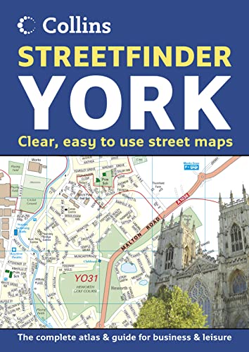
Paperback. Condizione: Very Good. Scale: Town plan at 4 inches to 1 mile, Road map at 9 miles to 1 inch. Brand new fully detailed street level mapping, complete with 9 mile road mapping of the surrounding area. Includes information section. MAIN FEATURES Full colour street atlas combining two different scales of mapping: detaile…d town centre maps at 4 inches to 1 mile and a clear route planning map of the area surrounding York city centre at 9 miles to 1 inch. INCLUDES / large scale city centre street level mapping, fully indexed / local information section with important contacts and details / road mapping at 9 miles to 1 inch, centred on the city / city centre shown at extra large 8 inches to 1 mile scale for extra clarity / postal districts clearly shown AREA OF COVERAGE The atlas covers a large area of York and the surrounding area, extending from Strensall in the north to Bishopthorpe in the south, and from Upper Poppleton in the west to Dunnington in the east. The book has been read, but is in excellent condition. Pages are intact and not marred by notes or highlighting. The spine remains undamaged.
Lingua: Inglese
Editore: HarperCollins Publishers, United Kingdom, London 2003
- Brossura
Da: WorldofBooks, Goring-By-Sea, WS, Regno UnitoWorldofBooks
Contatta il venditoreVenditore con 5 stelleCondizione: Usato - Molto buono
EUR 10,10
EUR 6,48 spedizioneSpedito da Regno Unito a U.S.A.Quantità: 1 disponibili
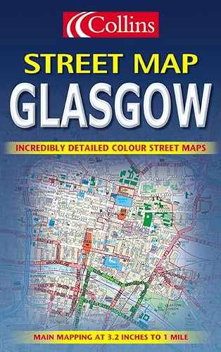
Paperback. Condizione: Very Good. Central area at 6.3 inches to 1 mile. Surrounding area at 3.2 inches to 1 mile. Full colour street level mapping with index to street names. MAIN FEATURES This exceptional detailed street level mapping covers a large area of this popular city. The central area is shown at an extra large scale to… aid clarity. INCLUDES Full colour map detail with Key to Symbols in English, French and German Large scale 6 inches to 1 mile central area Shows one way streets, pedestrian areas, car parks, station etc. All important buildings and places of interest AREA OF COVERAGE From Renfrew in the west to Easterhouse in the east and from Bearsden in the north to Clarkston in the south. WHO THE PRODUCT IS OF INTEREST TO All visitors, tourist, business people and residents who travel around the city. The book has been read, but is in excellent condition. Pages are intact and not marred by notes or highlighting. The spine remains undamaged.
- Brossura
Da: Greener Books, London, , Regno UnitoGreener Books
Contatta il venditoreVenditore con 4 stelleCondizione: Usato - Buono
EUR 4,15
EUR 18,49 spedizioneSpedito da Regno Unito a U.S.A.Quantità: 1 disponibili
Paperback. Condizione: Used; Good. **SHIPPED FROM UK** We believe you will be completely satisfied with our quick and reliable service. All orders are dispatched as swiftly as possible! Buy with confidence! Greener Books.

Da: Sell Books, Elland, YORKS, Regno UnitoSell Books
Contatta il venditoreVenditore con 5 stelleCondizione: Usato - Buono
EUR 29,42
EUR 14,05 spedizioneSpedito da Regno Unito a U.S.A.Quantità: 1 disponibili
map. Condizione: Good. Our good condition books are generally good for reading but not for gifting or collecting. They could have imperfections such as creasing, fanning, inscriptions, margin notes, yellowing, staining on edge or cover or pages, bumps, scuffs, etc etc (sometimes multiple of these). It's a wide category that enco…mpasses anything that isn't almost-new down to anything that is slightly better than poor. We would NOT recommend gifting Good books - these should be considered reading copies. Our books are dispatched from a Yorkshire former cotton mill. We list via barcode/ISBN so please note that the images are stock images and may not be the exact copy you receive, furthermore the details about edition and year might not be accurate as many publishers reuse the same ISBN for multiple editions and as we simply scan a barcode or enter an ISBN we do not check the validity of the edition data when listing. If you're looking for an exact edition please don't order (at least not without checking with us first, although we don't always have time to check). We aim to dispatch prompty, the service used will depend on order value and book size. We can ship to most countries, see our shipping policies. Payment is via Abe only.
- Brossura
Da: The Book Spot, Sioux Falls, MN, U.S.A.The Book Spot
Contatta il venditoreVenditore con 5 stelleCondizione: Nuovo
EUR 106,46
Spedizione gratuitaSpedito in U.S.A.Quantità: 1 disponibili
Paperback. Condizione: New.

Editore: London : Times Books 2003
- Rilegato
Da: MW Books, New York, NY, U.S.A.MW Books
Contatta il venditoreVenditore con 5 stelleCondizione: Usato
EUR 101,05
Spedizione gratuitaSpedito in U.S.A.Quantità: 1 disponibili
11th edition. Fine copy in the original colour-printed boards, in a very good, slightly bumped slip-case. Remains particularly well-preserved overall; tight, bright, clean and strong. Physical description; 1 atlas (1 volume (various pagings)) : color illustrations, color maps ; 46 cm. Subjects; Atlases Great Britain. Atlas brita…nniques. Atlases. World maps. Atlases Great Britain. Atlases, British. Atlases Geography. World 2003 ; Atlases. Scales differ. 3 Kg.

Editore: London : Times Books 2003
- Rilegato
Da: MW Books Ltd., Galway, , IrlandaMW Books Ltd.
Contatta il venditoreVenditore con 5 stelleCondizione: Usato
EUR 100,00
EUR 13,95 spedizioneSpedito da Irlanda a U.S.A.Quantità: 1 disponibili
11th edition. Fine copy in the original colour-printed boards, in a very good, slightly bumped slip-case. Remains particularly well-preserved overall; tight, bright, clean and strong. Physical description; 1 atlas (1 volume (various pagings)) : color illustrations, color maps ; 46 cm. Subjects; Atlases Great Britain. Atlas brita…nniques. Atlases. World maps. Atlases Great Britain. Atlases, British. Atlases Geography. World 2003 ; Atlases. Scales differ. 1 Kg.
The Times comprehensive atlas of the world
Collins Bartholomew Ltd. Staples, Chris. Times Book Group (Firm)
Editore: London : Times Book Group 2007
- Rilegato
- Prima edizione
Da: MW Books, New York, NY, U.S.A.MW Books
Contatta il venditoreVenditore con 5 stelleCondizione: Usato
EUR 123,67
Spedizione gratuitaSpedito in U.S.A.Quantità: 1 disponibili
12th Edition. Fine copy in the original color printed boards in an equally fine slip-case. Particularly and uncommonly well-preserved; tight, bright, clean and especially sharp-cornered. Physical description; 1 atlas (1 v. (various pagings)) : col. ill., col. maps ; 47 cm. Notes; Relief shown by shading and spot heights. Depths…shown by contours and gradient tints. "Maps [copyright] Collins Bartholomew Ltd"--T.p. verso. Rev. ed. of: The Times atlas of the world. 1st US ed., 10th comprehensive ed. c. 1999. Issued in slip case. Includes glossary and index. Contents; Partial contents Earth today: Images of Earth -- Stars and planets -- World today -- Mapping the world -- Geographical information -- Atlas of the world: Oceania -- Asia -- Europe -- Africa -- North America -- South America -- Antarctica -- Oceans -- Glossary -- Index -- Acknowledgements. Subjects; Atlases, British. Atlases Great Britain. World maps. Atlases Great Britain. World ; Atlases. earth (planet). atlases. World 2007 ; Atlases. Genres; Atlases. cartographic image. 5 Kg.

The Times comprehensive atlas of the world
Collins Bartholomew Ltd. Staples, Chris. Times Book Group (Firm)
Editore: London : Times Book Group 2007
- Rilegato
- Prima edizione
Da: MW Books Ltd., Galway, , IrlandaMW Books Ltd.
Contatta il venditoreVenditore con 5 stelleCondizione: Usato
EUR 125,00
EUR 13,95 spedizioneSpedito da Irlanda a U.S.A.Quantità: 1 disponibili
12th Edition. Fine copy in the original color printed boards in an equally fine slip-case. Particularly and uncommonly well-preserved; tight, bright, clean and especially sharp-cornered. Physical description; 1 atlas (1 v. (various pagings)) : col. ill., col. maps ; 47 cm. Notes; Relief shown by shading and spot heights. Depths…shown by contours and gradient tints. "Maps [copyright] Collins Bartholomew Ltd"--T.p. verso. Rev. ed. of: The Times atlas of the world. 1st US ed., 10th comprehensive ed. c. 1999. Issued in slip case. Includes glossary and index. Contents; Partial contents Earth today: Images of Earth -- Stars and planets -- World today -- Mapping the world -- Geographical information -- Atlas of the world: Oceania -- Asia -- Europe -- Africa -- North America -- South America -- Antarctica -- Oceans -- Glossary -- Index -- Acknowledgements. Subjects; Atlases, British. Atlases Great Britain. World maps. Atlases Great Britain. World ; Atlases. earth (planet). atlases. World 2007 ; Atlases. Genres; Atlases. cartographic image. 4 Kg.


