
Importo totale (1 articolo articoli):
Destinazione ordine:

corbridge james (19 risultati)
Vai alla pagina principale dei risultati di ricerca
Filtri di ricerca
Tipo di articolo
- Tutti i tipi di prodotto
- Libri (16)
- Riviste e Giornali (Nessun altro risultato corrispondente a questo perfezionamento)
- Fumetti (Nessun altro risultato corrispondente a questo perfezionamento)
- Spartiti (Nessun altro risultato corrispondente a questo perfezionamento)
- Arte, Stampe e Poster (Nessun altro risultato corrispondente a questo perfezionamento)
- Fotografie (Nessun altro risultato corrispondente a questo perfezionamento)
- Mappe (3)
- Manoscritti e Collezionismo cartaceo (Nessun altro risultato corrispondente a questo perfezionamento)
Condizioni Maggiori informazioni
Legatura
Ulteriori caratteristiche
- Prima ed. (Nessun altro risultato corrispondente a questo perfezionamento)
- Copia autograf. (Nessun altro risultato corrispondente a questo perfezionamento)
- Sovracoperta (1)
- Con foto (5)
- Non Print on Demand (19)
Lingua (2)
Spedizione gratuita
Paese del venditore
Valutazione venditore
-
Water Resource Management: A Casebook in Law and Public Policy (University Casebook Series)
Da: ThriftBooks-Atlanta, AUSTELL, GA, U.S.A.
Valutazione del venditore 5 su 5 stelle

Hardcover. Condizione: Very Good. No Jacket. Former library book; Missing dust jacket; May have limited writing in cover pages. Pages are unmarked. ~ ThriftBooks: Read More, Spend Less.
-
Water Resource Management : A Casebook in Law and Public Policy
Da: Better World Books, Mishawaka, IN, U.S.A.
Valutazione del venditore 5 su 5 stelle
Condizione: Good. Used book that is in clean, average condition without any missing pages.
-
Hardcover. Condizione: Good. Connecting readers with great books since 1972! Used textbooks may not include companion materials such as access codes, etc. May have some wear or writing/highlighting. We ship orders daily and Customer Service is our top priority!
-
Hardcover. Condizione: Acceptable. Connecting readers with great books since 1972. Used textbooks may not include companion materials such as access codes, etc. May have condition issues including wear and notes/highlighting. We ship orders daily and Customer Service is our top priority!
-
Water Resource Management: A Casebook in Law and Public Policy (University Casebook Series)
Da: Once Upon A Time Books, Siloam Springs, AR, U.S.A.
Valutazione del venditore 4 su 5 stelle

Hardcover. Condizione: Acceptable. This is a used book. It may contain highlighting/underlining and/or the book may show heavier signs of wear . It may also be ex-library or without dustjacket. This is a used book. It may contain highlighting/underlining and/or the book may show heavier signs of wear . It may also be ex-library or without dustjacket.
-
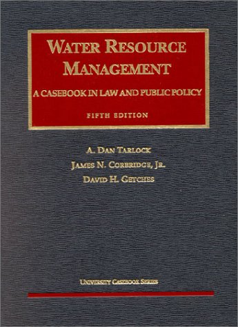
Water Resource Management: A Casebook in Law and Public Policy: Fifth Edition
Lingua: Inglese
Editore: Foundation Press, Inc., New York, New York, U.S.A., 2002
ISBN 10: 1587780690 ISBN 13: 9781587780691
Da: Squirrel Away Books, Loveland, CO, U.S.A.
Valutazione del venditore 2 su 5 stelle

Hardcover. Condizione: Near Fine. No Jacket. 5th Edition. Near Fine condition Hardcover Quarto with no dust jacket (probably as issued), 2002, 5th edition. The only marking I can find on this book is the inscription to Raphael J. Moses and signature by author David Getches on the FFEP. Association copy. Size: 4to - over 9" - 12" tall. Inscribed and Signed By Author. Book.
-

Rocky Mountain Lichen Primer
Lingua: Inglese
Editore: University Press of Colorado, 1998
ISBN 10: 0870814907 ISBN 13: 9780870814907
Da: Goodwill of Colorado, COLORADO SPRINGS, CO, U.S.A.
Valutazione del venditore 5 su 5 stelle
Condizione: acceptable. This item is in overall acceptable condition. Covers and dust jackets are intact but may have heavy wear including creases, bends, edge wear, curled corners or minor tears as well as stickers or sticker-residue. Pages are intact but may have minor curls, bends or moderate to considerable highlighting writing. Binding is intact; however, spine may have heavy wear. Digital codes may not be included and have not been tested to be redeemable and or active. A well-read copy overall. Please note that all items are donated goods and are in used condition. Orders shipped Monday through Friday! Your purchase helps put people to work and learn life skills to reach their full potential. Orders shipped Monday through Friday. Your purchase helps put people to work and learn life skills to reach their full potential. Thank you!
-
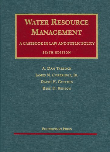
Water Resource Management: A Casebook in Law and Public Policy
Lingua: Inglese
Editore: Foundation Press, MN, St. Paul, 2014
ISBN 10: 1609302737 ISBN 13: 9781609302733
Da: BIBLIOPE by Calvello Books, Oakland, CA, U.S.A.
Valutazione del venditore 4 su 5 stelle
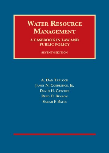
Hardcover. Condizione: Near fine. Seventh edition. Large Octavo, 911pages; 26 cm. Volume addresses both traditional water law rules and modern water management challenges. Covering Eastern and Western U.S. water law in detail, while examining both classic principles and statutory modifications of the riparian rights and prior appropriation doctrines. Explorations cover public dimensions of water law, with chapters devoted to public water uses and the Public Trust Doctrine, environmental quality issues in water management, and government takings relating to water use restrictions and flood damages. // **Somewhat heavy item. Additional shipping fees may be needed for expedited or international orders. Please inquire**. Near fine, navy blue boards, gilt titles are crisp and clean, very light shelf-wear to tips, else corners are sharp, slight cock to binding, textblock firm and tight; pages are crisp, bright, and clean.
-
Condizione: Good. Exact ISBN match. Immediate shipping. No funny business.
-
Water Resource Management, A Casebook in Law and Public Policy
Da: Better World Books, Mishawaka, IN, U.S.A.
Valutazione del venditore 5 su 5 stelle
Condizione: Good. 6 Edition. Used book that is in clean, average condition without any missing pages.
-
Water Resource Management, A Casebook in Law and Public Policy: Water Resource Management, A Casebook in Law and Public Policy, 6th (University Casebook Series)
Da: The Book Spot, Sioux Falls, MN, U.S.A.
Valutazione del venditore 4 su 5 stelle
Hardcover. Condizione: New.
-
Water Resource Management, A Casebook in Law and Public Policy: Water Resource Management, A Casebook in Law and Public Policy, 6th (University Casebook Series)
Da: ThriftBooks-Atlanta, AUSTELL, GA, U.S.A.
Valutazione del venditore 5 su 5 stelle
Hardcover. Condizione: As New. No Jacket. Pages are clean and are not marred by notes or folds of any kind. ~ ThriftBooks: Read More, Spend Less.
-
Water Resource Management, A Casebook in Law and Public Policy: Water Resource Management, A Casebook in Law and Public Policy, 6th (University Casebook Series)
Da: ThriftBooks-Dallas, Dallas, TX, U.S.A.
Valutazione del venditore 5 su 5 stelle
Hardcover. Condizione: Fair. No Jacket. Readable copy. Pages may have considerable notes/highlighting. ~ ThriftBooks: Read More, Spend Less.
-
Hardcover. Condizione: Acceptable. Connecting readers with great books since 1972. Used textbooks may not include companion materials such as access codes, etc. May have condition issues including wear and notes/highlighting. We ship orders daily and Customer Service is our top priority!
-

Rocky Mountain Lichen Primer
Lingua: Inglese
Editore: University Press of Colorado, 1998
ISBN 10: 0870814907 ISBN 13: 9780870814907
Condizione: new.
-
Water Resource Management, A Casebook in Law and Public Policy: Water Resource Management, A Casebook in Law and Public Policy, 6th (University Casebook Series)
Da: Mispah books, Redhill, SURRE, Regno Unito
Valutazione del venditore 4 su 5 stelle
EUR 282,62
Spedizione EUR 28,82
Spedito da Regno Unito a U.S.A.Quantit�: 1 disponibili
Aggiungi al carrelloHardcover. Condizione: Acceptable. Acceptable. Dust Jacket NOT present. CD WILL BE MISSING. SHIPS FROM MULTIPLE LOCATIONS. book.
-

An Actual Survey of the County of Norfolk, to w.ch will be added an Actual Survey of ye County of Suffolk
Editore: Thomas Bowles, John Bowles and Robert Sayer, London, 1735
Da: Clive A. Burden Ltd., Chalfont St. Giles, BUCKS, Regno Unito
Membro dell'associazione: ABA ILAB
Valutazione del venditore 5 su 5 stelle
Mappa
EUR 1.128,09
Spedizione EUR 25,54
Spedito da Regno Unito a U.S.A.Quantit�: 1 disponibili
Aggiungi al carrelloNo binding. 550 x 700 mm., early outline colour, cut, dissected and laid on linen as issued. A couple of light marks and two small worm tracks at the edge lower right, otherwise in good condition. James Corbridge was a surveyor in Norwich in the first half of the eighteenth century. He produced numerous estate plans but is best known for his large scale maps of Norfolk, Norwich and Great Yarmouth. His career began in Newcastle and amongst his early work is the first plan of the town. In the early 1720s he moved to Norwich and in 1730 he published his great large scale map of the county of Norfolk, the first to be printed. In 1735 he published this large single sheet reduction complete with extensive lists of the towns and villages in the county in surrounding panels. Each is keyed to the map and has their Hundred identified along with the distance in miles from Norwich. Circles of distance from Kings Lynn and Norwich radiate the map. The coastline is decorated with ornate images of seven boats and ships. Top centre can be found Corbridge's dedication to Baron Walpole. The map is engraved to the scale of three miles to the inch, each grid marking three miles. The year after the publication of the larger map Thomas Goddard and William Chase published a pirated copy. In this reduction by Corbridge he could not resist having a go at them about the scale of miles stating lower right 'I refer them to Mr. Chase and his Map (if they doubt my Scale of Miles which contains 1760 yards) for if I mistake not he has given three Scales to his Map which he calls Great Middle and Small, things Uncommon in Surveys of Countys and as useless as the 3 heads Imploy'd in Copying My Late Map of Norfolk'. Thomas and John Bowles and Robert Sayer were the publishers of the second edition of the Norwich town plan and the original map of Norfolk. The map is NOT LISTED IN RODGER'S list of large scale maps and only one example appears to have ever appeared at auction. According to Raymond Frostick this is the second of four known states. Frostick, James Corbridge, IMCoS Journal no. 115 pp. 33-40; Frostick (2011) 29.2; not in Rodger (1972).
-

An Actual Survey of the County of Norfolk, to w.ch will be added an Actual Survey of ye County of Suffolk
Editore: Thomas Bowles, Robert Wilkinson and Robert Sayer, London, 1735
Da: Clive A. Burden Ltd., Chalfont St. Giles, BUCKS, Regno Unito
Membro dell'associazione: ABA ILAB
Valutazione del venditore 5 su 5 stelle
Mappa
EUR 1.128,09
Spedizione EUR 25,54
Spedito da Regno Unito a U.S.A.Quantit�: 1 disponibili
Aggiungi al carrelloNo binding. 515 x 700 mm., early outline colour, with light vertical fold parallel to the centrefold, otherwise in good condition. James Corbridge was a surveyor in Norwich in the first half of the eighteenth century. He produced numerous estate plans but is best known for his large scale maps of Norfolk, Norwich and Great Yarmouth. His career began in Newcastle and amongst his early work is the first plan of the town. In the early 1720s he moved to Norwich and in 1730 he published his great large scale map of the county of Norfolk, the first to be printed. In 1735 he published this large single sheet reduction complete with extensive lists of the towns and villages in the county in surrounding panels. Each is keyed to the map and has their Hundred identified along with the distance in miles from Norwich. Circles of distance from Kings Lynn and Norwich radiate the map. The coastline is decorated with ornate images of seven boats and ships. Top centre can be found Corbridge's dedication to Baron Walpole. The map is engraved to the scale of three miles to the inch, each grid marking three miles. The year after the publication of the larger map Thomas Goddard and William Chase published a pirated copy. In this reduction by Corbridge he could not resist having a go at them about the scale of miles stating lower right 'I refer them to Mr. Chase and his Map (if they doubt my Scale of Miles which contains 1760 yards) for if I mistake not he has given three Scales to his Map which he calls Great Middle and Small, things Uncommon in Surveys of Countys and as useless as the 3 heads Imploy'd in Copying My Late Map of Norfolk'. Thomas and John Bowles and Robert Sayer were the publishers of the second edition of the Norwich town plan, the original map of Norfolk and this plate. In the summer of 1779 John Bowles died and his business was acquired by Robert Wilkinson by the end of the year. The map is NOT LISTED IN RODGER'S list of large scale maps and only one example appears to have ever appeared at auction. According to Raymond Frostick this is the third of four known states. Frostick, James Corbridge, 'IMCoS Journal' no. 115 pp. 33-40; Frostick Norfolk 29.3; not in Rodger (1972).
-

An Actual Survey of the County of Norfolk
Editore: Printed for T. Bowles in St Paul's Church Yard, John Bowles in Cornhill, and Robert Sayer at the Golden Buck in Fleet Street, [c1765]., London,, 1765
Da: Daniel Crouch Rare Books Ltd, London, Regno Unito
Membro dell'associazione: ABA ILAB PBFA
Valutazione del venditore 4 su 5 stelle
Mappa
EUR 1.187,46
Spedizione EUR 23,06
Spedito da Regno Unito a U.S.A.Quantit�: 1 disponibili
Aggiungi al carrelloNorfolk - Corbridge's rare maps of Norfolk Engraved map, dissected and mounted on linen. James Corbridge was a surveyor in Norwich in the first half of the eighteenth century. He produced numerous estate plans but is best known for his large scale maps of Norfolk, Norwich and Great Yarmouth. His career began in Newcastle and amongst his early work is the first plan of the town. In the early 1720s he moved to Norwich and in 1730 he published his great large scale map of the county of Norfolk, the first to be printed. In 1735 he published this large single sheet reduction complete with extensive lists of the towns and villages in the county in surrounding panels. Each is keyed to the map and has their Hundred identified along with the distance in miles from Norwich. Circles of distance from Kings Lynn and Norwich radiate the map. The coastline is decorated with ornate images of seven boats and ships. Top centre can be found Corbridge's dedication to Baron Walpole. The map is engraved to the scale of three miles to the inch, each grid marking three miles. The year after the publication of the larger map Thomas Goddard and William Chase published a pirated copy. In this reduction by Corbridge he could not resist having a go at them about the scale of miles stating lower right 'I refer them to Mr. Chase and his Map (if they doubt my Scale of Miles which contains 1760 yards) for if I mistake not he has given three Scales to his Map which he calls Great Middle and Small, things Uncommon in Surveys of Countys and as useless as the 3 heads Imploy'd in Copying My Late Map of Norfolk'. Thomas and John Bowles and Robert Sayer were the publishers of the second edition of the Norwich town plan and the original map of Norfolk. The map is NOT LISTED IN RODGER'S list of large scale maps and only one example appears to have ever appeared at auction. According to Raymond Frostick this is the second of four known states. Bookplate of R. C. Fiske. Frostick, James Corbridge, IMCoS Journal no. 115 pp. 33-40; Frostick Norfolk 27.2; not in Rodger.
