County atlas (22 risultati)

National Geographic Magazine - November, 2017. Search for Happiness; Happiness Atlas; Pterosaurs; Okavango; North Korea; Why Vaccines Matter; County Fair Animals That Don't Win
Susan Goldberg (Editor-in-Chief) / Search for Happiness; Happiness Atlas; Pterosaurs; Okavango; North Korea; Why Vaccines Matter; County Fair Animals That Don't Win.
Editore: National Geographic Society 2017
- Brossura
- Periodico
Da: Shore Books, London, Regno UnitoShore Books
Contatta il venditoreVenditore con 5 stelleCondizione: Usato - Molto buono
EUR 7,16
EUR 12,75 spedizioneSpedito da Regno Unito a U.S.A.Quantità: 1 disponibili
Soft cover. Condizione: Very Good. 146 pages. Feature articles include: Search for Happiness; Happiness Atlas; Pterosaurs; Okavango; North Korea; Why Vaccines Matter; County Fair Animals That Don't Win. There are also, of course, the numerous - and always deeply engaging - shorter features, departments, graphics, even absorbing…ads.

Lingua: Inglese
Editore: Ross Cumming, Port Elgin, ON 1972
- Rilegato
Da: Old Favorites Bookshop LTD (since 1954), Stouffville, ON, CanadaOld Favorites Bookshop LTD (since 1954)
Contatta il venditoreVenditore con 4 stelleCondizione: Usato - Buono
EUR 76,86
EUR 8,78 spedizioneSpedito da Canada a U.S.A.Quantità: 1 disponibili
Hardcover. Condizione: Good Condition. Condizione sovraccoperta: No Dust Jacket. As Issued. Reprint Edition. Black binding with gilt Design and title on front cover. 88pp. Content clean, bright and sound. This book is large and may require additional postage. Photos available on request.
Lingua: Inglese
Editore: Cumming Publishers, Stratford, ON. 1982
- Rilegato
Da: Old Favorites Bookshop LTD (since 1954), Stouffville, ON, CanadaOld Favorites Bookshop LTD (since 1954)
Contatta il venditoreVenditore con 4 stelleCondizione: Usato - Molto buono
EUR 85,90
EUR 8,78 spedizioneSpedito da Canada a U.S.A.Quantità: 1 disponibili
Boards with Cloth Spine. Condizione: Very Good Condition. . Blue boards wht black cloth spine. Front cover illustrated with Gilt County of Perth Crest and Gilt lettering. This book is large and may require additional postage. pHOTOS AVAILABLE ON REQUEST. Illustrated with Maps and B/W Photos. (illustratore).
Lingua: Inglese
Editore: Offset Edition, Port Elgin, ON. 1971
- Rilegato
Da: Old Favorites Bookshop LTD (since 1954), Stouffville, ON, CanadaOld Favorites Bookshop LTD (since 1954)
Contatta il venditoreVenditore con 4 stelleCondizione: Usato - Molto buono
EUR 113,02
EUR 8,78 spedizioneSpedito da Canada a U.S.A.Quantità: 1 disponibili
Hardcover. Condizione: Very Good Condition. Condizione sovraccoperta: No Dust Jacket. As Issued. Limited Edition 1,500 Copies. Including City of Ottawa. Edited by Ross Cumming. Limited numbered edition. This book is large and may require additional postage. Photos available on request. Illustrationed with Maps and Illustrations…(illustratore).
Lingua: Inglese
Editore: Peter Martin Associates Limited, Toronto 1969
- Rilegato
Da: Old Favorites Bookshop LTD (since 1954), Stouffville, ON, CanadaOld Favorites Bookshop LTD (since 1954)
Contatta il venditoreVenditore con 4 stelleCondizione: Usato - Molto buono
EUR 226,05
EUR 8,78 spedizioneSpedito da Canada a U.S.A.Quantità: 1 disponibili
Hardcover. Condizione: Very Good Condition. Condizione sovraccoperta: No Dust Jacket. As Issued. Mustard color cloth binding with black illustrations of original title page on front covr. 64pp. Top and bottom of spine aand corners of binding bumped. Content clean, bright and sound. No interior faults. This book may require addit…ional postage. Photos available on request. B/W Maps and Drawings (illustratore).
Editore: Mika Studios 1878
- Rilegato
Da: THE FINE BOOKS COMPANY / A.B.A.A / 1979, ROCHESTER, MI, U.S.A.THE FINE BOOKS COMPANY / A.B.A.A / 1979
Contatta il venditoreVenditore con 4 stelleCondizione: Usato
EUR 68,17
EUR 10,97 spedizioneSpedito in U.S.A.Quantità: 1 disponibili
Illustrated Historical Atlas of the County of York and the Township of West Gwillimbury & Town of Bradford in the County of Simcoe, Ont. Toronto: Miles & Co. 1878., Mika Studios, N.d., a near fine copy of this reprint elephant folio facsimile edition with gold gilt stamping and lettering on the front cover.
 Altre immagini
Da: Antic Hay Books, Asbury Park, NJ, U.S.A.Antic Hay Books
Contatta il venditoreVenditore con 5 stelleCondizione: Usato
EUR 45,21
EUR 6,58 spedizioneSpedito in U.S.A.Quantità: 1 disponibili
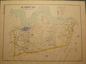
[WOLVERTON'S ATLAS OF MONMOUTH COUNTY]. RARITAN MAP, 1889. A 15-inch by 18-inch hand-colored map of Raritan, showing the Union, Keyport, Bethany, Centerville, and Granville school districts. $50.00.
[Cover title]. Multnomah County maps. 1000 to 1 inch. . . .
[OREGON -- MULTNOMAH COUNTY ATLAS]. SMITH, Wiley W. (Assessor).
Editore: Multnomah County Assessor's Office, [ca. 1950]., [Portland, OR]: 1950
- Rilegato
- Prima edizione
Da: Zephyr Used & Rare Books, Vancouver, WA, U.S.A.Zephyr Used & Rare Books
Contatta il venditoreVenditore con 5 stelleCondizione: Usato
EUR 406,88
EUR 7,02 spedizioneSpedito in U.S.A.Quantità: 1 disponibili
Oblong folio. 21 x 13.5 in. [1], 1-71, 74 leaves (as issued). Including Multnomah County key map, w/ 73 whiteprint diazo process maps, all w/ borders (key map w/ small closed tear at lower fore-edge w/ ghosting from old removed scotch tape, now neatly repaired on verso). Original black cloth post-binder, gilt lettering stamped o…n front cover, 3 nickel-plates screwposts at gutter margin (minor rubbing), still VG copy. First edition, thus, of this exceedingly scarce plat map atlas for Multnomah County, Oregon surveyed and issued after the famed May 30, 1948 Memorial Day flood destroyed Vanport, the Wartime Housing Authority of Portland project still existing following V-J Day 3 years earlier. The Vanport community housed the majority of African-American residents in Oregon who were prevented through racist real estate covenants and local ordinances from moving elsewhere prior to the flood, and afterwards 1000's were confined to the Albina area of North Portland. In addition, the ongoing highway project for Highway 99, or the Pacific Highway is still demarcated, without reference to I-5, which after the 1956 Highway Act would eventually serve to sever North Portland, and eliminate entire neighborhoods when later completed. These maps offer an essential snapshot of development in Post-War Portland, and guide to neighborhoods and land developments radically changed by expansion of the Portland Airport, Interstate Construction, and more. Worldcat locates 1 copy (OR Hist. Soc. Lib. (incorrect collation)).
 Altre immagini
Editore: Titus, Simmons & Titus, Philadelphia 1877
- Rilegato
- Prima edizione
Da: The First Edition Rare Books, LLC, Cincinnati, OH, U.S.A.The First Edition Rare Books, LLC
Contatta il venditoreVenditore con 5 stelleCondizione: Usato - Molto buono
EUR 11.302,26
EUR 5,27 spedizioneSpedito in U.S.A.Quantità: 1 disponibili
Quarter Leather. Condizione: Very good. First Edition. Oblong folio, 231pp, [2]. Rebound in quarter black leather, publisher's blindstamped brown cloth boards, stamped and embossed with title on the cover. Binding by Oldach & Mergenthaler Binders of Philadelphia. Engravings by Worley & Bracher, printed by H.J. Toudy & Company. T…he compiler, Eli L. Hayes, was assisted by E.F. Hayes, C.M. Beresford, S.A. Charpiot, F.L. Sanford, and J.H. Sherman. This work includes the Index Map, and foldout maps of Pittsburgh-Allegheny, Pomeroy, Huntington, and Cincinnati. All other maps (25), plates, and tables are complete. Notable soiling to preliminary leaves, thumb prints along margins. Repairs to hinges of the Cincinnati and Pittsburgh foldouts, tape repairs to verso. Text block solid, strong hinges. New endpapers, original pastedowns. (Rieger, 46) (Howes H-345) (Runmsey 4975) (Thomson, Ohio Bibliography, 532) Exceptionally scarce, with only two known examples appearing on public auction. The Illustrated Atlas Of The Upper Ohio River And Valley, From Pittsburgh, Pa. to Cincinnati, Ohio, published in 1877 by Eli L. Hayes, known as "the most extraordinary 'county atlas' produced in the 19th century." Complete with all plates and fold-ou (illustratore).
 Altre immagini
Editore: Underwriter's Survey Bureau, Toronto & Montreal 1949
- Rilegato
Da: David Mason Books (ABAC), Toronto, ON, CanadaDavid Mason Books (ABAC)
Contatta il venditoreVenditore con 5 stelleCondizione: Usato
EUR 764,72
EUR 15,80 spedizioneSpedito da Canada a U.S.A.Quantità: 1 disponibili
Atlas. Folio (55.1 x 31.5 cm), Green cloth covered boards with rivets on the inside, which hold the maps between the boards (there is no spine as issued), 18 double page linen backed maps. Some wear to the edges of the boards, particularly the lower left hand cornerof the upper board that has a strip of wear extending 10cms up f…rom the bottom, but o/w very good. Uncommon.
 Altre immagini
Editore: H.H. Hardesty & Co, Chicago 1875
- Rilegato
- Prima edizione
Da: The First Edition Rare Books, LLC, Cincinnati, OH, U.S.A.The First Edition Rare Books, LLC
Contatta il venditoreVenditore con 5 stelleCondizione: Usato - Molto buono
EUR 655,53
EUR 5,27 spedizioneSpedito in U.S.A.Quantità: 1 disponibili
Cloth. Condizione: Very good. First Edition. Largo folio (14.5" x 20"). Burgundy cloth, title in gilt on spine and front cover. Some wear at edges, endpapers a bit worn, stain to last 5 pages and rear endpaper. Some separation at front hinge, text block solid. Comprised of 43 large color maps, many foldout, double-page maps, a "…Special Map" of Ohio, Indiana, Illinois, Wisconsin and Michigan. Numerous inserts with maps and etchings from Wood County Ohio. Includes a historical description of the county in the preface. This edition is similar to other copies, which focus on Henry County, Lucas County and Fulton County Ohio. A scarce work. Historical Atlas of the World, focusing on Wood County Ohio, from 1875. (illustratore).
 Altre immagini
Da: Antic Hay Books, Asbury Park, NJ, U.S.A.Antic Hay Books
Contatta il venditoreVenditore con 5 stelleCondizione: Usato
EUR 67,81
EUR 6,58 spedizioneSpedito in U.S.A.Quantità: 1 disponibili
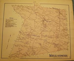
[F.W. BEERS ATLAS OF MONMOUTH COUNTY]. MILLSTONE TOWNSHIP MAP, 1873. A 16-inch by 13-inch hand-colored map of Millstone. $75.00.
 Altre immagini
Da: Antic Hay Books, Asbury Park, NJ, U.S.A.Antic Hay Books
Contatta il venditoreVenditore con 5 stelleCondizione: Usato
EUR 67,81
EUR 6,58 spedizioneSpedito in U.S.A.Quantità: 1 disponibili
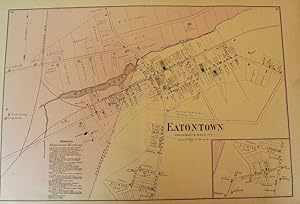
[F.W. BEERS ATLAS OF MONMOUTH COUNTY]. EATONTOWN MAP, 1873. A 13-inch by 24-inch hand-colored map of Eatontown showing, Shrewsbury and Ocean Township. $75.00.
 Altre immagini
Da: Antic Hay Books, Asbury Park, NJ, U.S.A.Antic Hay Books
Contatta il venditoreVenditore con 5 stelleCondizione: Usato
EUR 76,86
EUR 6,58 spedizioneSpedito in U.S.A.Quantità: 1 disponibili
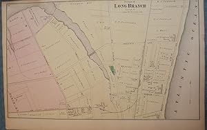
[F.W. BEERS ATLAS OF MONMOUTH COUNTY]. LONG BRANCH, 1873 MAP. A 13-inch by 24-inch hand-colored map of a portion of Long Branch. $85.00.
Editore: Roe Brothers (1879), St. John & Portland, N.B. 1879
Da: Schooner Books Ltd.(ABAC/ALAC), Halifax, NS, CanadaSchooner Books Ltd.(ABAC/ALAC)
Contatta il venditoreVenditore con 4 stelleCondizione: Usato
EUR 248,65
EUR 21,95 spedizioneSpedito da Canada a U.S.A.Quantità: 1 disponibili
Eleven separate single sheets Pp. From "Atlas of the Maritime Provinces of the Dominion of Canada. With Historical and Geological Descriptions." Published 1879 by the Roe Brothers, St. John & Portland, N.B. Maps include County of Gloucester [Plate #35], Counties of Restigouche and Madawaska [Plate #24 & 25]; County of Northumber…land [Plate #38 & 39];County of Kent[Plate #41];County of Saint John[Plate #47]; Counties of Sunbury and Queens[Plate #43];County of York[Plate #31];County of Kings[Plate #45];County of Victoria[Plate #27]; County of Carleton [Plate #29]; County of Charlotte [Plate #33] All maps have minor damp staining and tears to edges but generally very good. All are single sheet with some topographic detail except for Northumberland & Restigouche and Madawaska which are double sheets Each single sheet with some topographic detail.
Atlas and directory of Lapeer County, Michigan 1893 [LeatherBound]
Dunham, F. A,Hubbard, F. J,Mueller, A. H. (August H.),Lapeer County Atlas Co,E. Robinson Co
- Rilegato
- Print on Demand
Da: True World of Books, Delhi, IndiaTrue World of Books
Contatta il venditoreVenditore con 5 stelleCondizione: Nuovo
EUR 27,12
Spedizione gratuitaSpedito da India a U.S.A.Quantità: 18 disponibili
LeatherBound. Condizione: New. BOOKS ARE EXEMPT FROM IMPORT DUTIES AND TARIFFS; NO EXTRA CHARGES APPLY. LeatherBound edition. Condition: New. Reprinted from 1893 edition. Leather Binding on Spine and Corners with Golden leaf printing on spine. Bound in genuine leather with Satin ribbon page markers and Spine with raised gilt ban…ds. A perfect gift for your loved ones. Pages: 86 NO changes have been made to the original text. This is NOT a retyped or an ocr'd reprint. Illustrations, Index, if any, are included in black and white. Each page is checked manually before printing. As this print on demand book is reprinted from a very old book, there could be some missing or flawed pages, but we always try to make the book as complete as possible. Fold-outs, if any, are not part of the book. If the original book was published in multiple volumes then this reprint is of only one volume, not the whole set. Sewing binding for longer life, where the book block is actually sewn (smythe sewn/section sewn) with thread before binding which results in a more durable type of binding. Pages: 86.
Map of the County of Marathon, Wisconsin, compiled and published by . . . .
[WISCONSIN, MARATHON COUNTY -- MAP ATLAS]. BUSSELL, [Charles Edward] & HOLWAY.
Editore: Bussell & Holway, Civil Engineers, [1881]., [Neillsville & Wasau, WI]: 1881
- Prima edizione
Da: Zephyr Used & Rare Books, Vancouver, WA, U.S.A.Zephyr Used & Rare Books
Contatta il venditoreVenditore con 5 stelleCondizione: Usato
EUR 497,30
EUR 7,02 spedizioneSpedito in U.S.A.Quantità: 1 disponibili
8vo. [180 pp (unpaginated).], with double-page engraved title, plat maps throughout, primarily on facing recto & verso of leaves, while some are overlapping and on next blank continuing, w/ laid-in Township, Range Plat Map, MS on form [4-590] demarcating Government Land, and dated March 6, 1895, inserted into rear pocket, annota…tions demarcating plat changes, red ink markings of "Government Land" w/ V's, and other annotations on several of the maps in Marathon County by former real estate land surveyor. Contemporary black calf (rebacked, hinges restored), w/ thumbing, some edgewear, still a VG- copy. First edition of this detailed, and compact pocket plat map atlas issued by Bussell (b. 1854) was a surveyor/civil engineer based out of nearby Neillsville, Clark, WI, and his partner Holway for lands platted through Marathon County, Wisconsin in the 19th-Century as the centrally located County opened for logging and settlement on lands driven by the Wisconsin Central Railroad, and the Wisconsin Valley Railroad (later the Wisconsin Valley Land Company). This exceptional reference provides names of all the original homesteaders and plat-holders as of the time of publication, as well as demarcating houses, churches, schools, mills, U.S. Government lands, state lands, as well as the lines for the Lake Shore Traffic Co., Dundee Land Co., and development lands of the C.P. Haseltine Co. Worldcat locates only 1 physical copy at Library of Congress (Wisconsin Historical Society does have a scanned searchable copy available online); See: Louise Marchetti, History of Marathon County, Wisconsin and Representative Citizens (1913).
 Altre immagini
Da: Antic Hay Books, Asbury Park, NJ, U.S.A.Antic Hay Books
Contatta il venditoreVenditore con 5 stelleCondizione: Usato
EUR 113,02
EUR 6,58 spedizioneSpedito in U.S.A.Quantità: 1 disponibili
[F.W. BEERS ATLAS OF MONMOUTH COUNTY]. SPRING LAKE, 1877: REIDS VILLA PARK. Upper picture frontal view of Reids Villa Park, lower picture frontal view of the residence of Rev. A.A. Willits, Spring Lake. Hand-colored. $125.00.
 Altre immagini
Da: Antic Hay Books, Asbury Park, NJ, U.S.A.Antic Hay Books
Contatta il venditoreVenditore con 5 stelleCondizione: Usato
EUR 135,63
EUR 6,58 spedizioneSpedito in U.S.A.Quantità: 1 disponibili
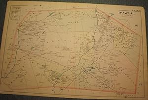
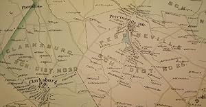
[WOLVERTON'S ATLAS OF MONMOUTH COUNTY]. HOWELL TOWNSHIP, 1889 MAP. A 20-inch by 30-inch hand-colored map of Howell Township, showing West Farms, Fairfield, Farmingdale, Jerseyville, Turkey Blue Ball, Greenville, Runyons, Bethel and Squankum. $150.00.
 Altre immagini
Da: Antic Hay Books, Asbury Park, NJ, U.S.A.Antic Hay Books
Contatta il venditoreVenditore con 5 stelleCondizione: Usato
EUR 135,63
EUR 6,58 spedizioneSpedito in U.S.A.Quantità: 1 disponibili
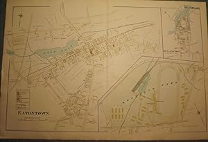
[WOLVERTON'S ATLAS OF MONMOUTH COUNTY]. EATONTOWN MAP, 1889. A 20-inch by 30-inch hand-colored map of Eatontown, also showing Monmouth Park and Oceanport. Probably one of the best early maps of Eatontown ever made. $150.00.
 Altre immagini
Da: Antic Hay Books, Asbury Park, NJ, U.S.A.Antic Hay Books
Contatta il venditoreVenditore con 5 stelleCondizione: Usato
EUR 135,63
EUR 6,58 spedizioneSpedito in U.S.A.Quantità: 1 disponibili
[WOLVERTON'S ATLAS OF MONMOUTH COUNTY]. MILLSTONE TOWNSHIP 1889 MAP. A 20-inch by 30-inch hand-colored map of Millstone Township, also showing the Navesink section of Middletown Township. $150.00.
 Altre immagini
Atlas and directory of Lapeer County, Michigan 1893 [Leather Bound]
Dunham, F. A,Hubbard, F. J,Mueller, A. H. (August H.),Lapeer County Atlas Co,E. Robinson Co
- Rilegato
- Print on Demand
Da: Gyan Books Pvt. Ltd., Delhi, IndiaGyan Books Pvt. Ltd.
Contatta il venditoreVenditore con 5 stelleCondizione: Nuovo
EUR 34,41
Spedizione gratuitaSpedito da India a U.S.A.Quantità: Più di 20 disponibili
Leather Bound. Condizione: New. Language: English. Language: English. Presenting an Exquisite Leather-Bound Edition, expertly crafted with Original Natural Leather that gracefully adorns the spine and corners. The allure continues with Golden Leaf Printing that adds a touch of elegance, while Hand Embossing on the rounded spine…lends an artistic flair. This masterpiece has been meticulously reprinted in 2024, utilizing the invaluable guidance of the original edition published many years ago in 1893. The contents of this book are presented in classic black and white. Its durability is ensured through a meticulous sewing binding technique, enhancing its longevity. Imprinted on top-tier quality paper. A team of professionals has expertly processed each page, delicately preserving its content without alteration. Due to the vintage nature of these books, every page has been manually restored for legibility. However, in certain instances, occasional blurriness, missing segments, or faint black spots might persist. We sincerely hope for your understanding of the challenges we faced with these books. Recognizing their significance for readers seeking insight into our historical treasure, we've diligently restored and reissued them. Our intention is to offer this valuable resource once again. We eagerly await your feedback, hoping that you'll find it appealing and will generously share your thoughts and recommendations. Lang: - English, Pages: - 86, Print on Demand. If it is a multi-volume set, then it is only a single volume. We are specialised in Customisation of books, if you wish to opt different color leather binding, you may contact us. This service is chargeable. Product Disclaimer: Kindly be informed that, owing to the inherent nature of leather as a natural material, minor discolorations or textural variations may be perceptible. Explore the FOLIO EDITION (12x19 Inches): Available Upon Request. 86 86.


