
Importo totale (1 articolo articoli):
Destinazione ordine:

davis major george (9 risultati)
Vai alla pagina principale dei risultati di ricerca
Filtri di ricerca
Tipo di articolo
- Tutti i tipi di prodotto
- Libri (8)
- Riviste e Giornali (1)
- Fumetti (Nessun altro risultato corrispondente a questo perfezionamento)
- Spartiti (Nessun altro risultato corrispondente a questo perfezionamento)
- Arte, Stampe e Poster (Nessun altro risultato corrispondente a questo perfezionamento)
- Fotografie (Nessun altro risultato corrispondente a questo perfezionamento)
- Mappe (Nessun altro risultato corrispondente a questo perfezionamento)
- Manoscritti e Collezionismo cartaceo (Nessun altro risultato corrispondente a questo perfezionamento)
Condizioni Maggiori informazioni
- Nuovo (Nessun altro risultato corrispondente a questo perfezionamento)
- Come nuovo, Ottimo o Quasi ottimo (3)
- Molto buono o Buono (5)
- Discreto o Mediocre (1)
- Come descritto (Nessun altro risultato corrispondente a questo perfezionamento)
Legatura
- Tutte
- Rilegato (8)
- Brossura (Nessun altro risultato corrispondente a questo perfezionamento)
Ulteriori caratteristiche
- Prima ed. (1)
- Copia autograf. (Nessun altro risultato corrispondente a questo perfezionamento)
- Sovracoperta (4)
- Con foto (5)
- Non Print on Demand (9)
Lingua (2)
Spedizione gratuita
Paese del venditore
Valutazione venditore
-
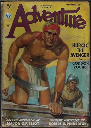
ADVENTURE: October, Oct. 15, 1935
Editore: Popular Publications, NY, 1935
Da: Books from the Crypt, N. Potomac, MD, U.S.A.
Membro dell'associazione: IOBA
Valutazione del venditore 5 su 5 stelle

Rivista / Giornale
SingleIssueMagazine. Condizione: Good. Vol. 93, No. 6. Edited by Howard V. L. Bloomfield. Cover art by Hubert Rogers. Includes "Huroc the Avenger" (pt. 1 of 6) by Gordon Young; "Gross Fire" (novelette) by Robert E. Pinkerton; "Flight Leader" by Bourke Lee; "Nobody's Horses" by S. Omar Barker; "No Help Needed" by Mody C. Boatright; "The Spider" (novelette) by Major George Fielding Eliot; "Brother of Lions" (fact story) by Wynant Davis Hubbard; "Surprise Attack" by Perry Adams. Features: "The Camp-Fire"; "Ask Adventure"; "The Trail Ahead". Illustrated by V. E. Pyles, I. Hazleton, and N. O'Keefe. Standard wear and tear; tears at heel; dust foiled; foxing; tanning; pencil marks on front and rear. Book.
-

The Official Military Atlas of the Civil War
Da: Smith Family Bookstore Downtown, Eugene, OR, U.S.A.
Valutazione del venditore 4 su 5 stelle

Hardcover. Condizione: Very Good. Condizione sovraccoperta: Very Good. edge wear, light creasing. light sun bleaching on spine and corners of dust jacket. a couple of small dots on fore edge. text is unmarked. binding solid, sound. additional postage required for international orders.
-

A Treatise on the Military Law of the United States: Together With the Practice and Procedure of Courts-martial and Other Military Tribunals : Third Edition, Revised
Editore: John Wiley & Sons, Inc., 1915
Da: My Dead Aunt's Books, Hyattsville, MD, U.S.A.
Valutazione del venditore 5 su 5 stelle
Hardcover. Condizione: Fair. Limited ed. of 5000; 564 p., clean with marks and notations on pp. 538-546; appendices A-P (pp. 565- 774) are clean and unmarked; stains found on upper fore-edges of pp. 790-813 of index, with chipping and open tears on corners of pp. 809 through rear end pages;; former owner's name in elegant hand on front end page. Binding firm but front gutter is cracked;; in absence of d.j. or slip case,dark blue boards with clear gilt lettering on spine are lightly scuffed with bumped corners.
-

The Official Military Atlas of the Civil War
Lingua: Inglese
Editore: Arno Press/Crown Publishers, Inc, New York, New York, 1978
ISBN 10: 0405111983 ISBN 13: 9780405111983
Da: North Slope Books, Lancaster, PA, U.S.A.
Valutazione del venditore 5 su 5 stelle
Hardcover. Condizione: Very Good+. Condizione sovraccoperta: Very Good. Color & B&w (illustratore). Wonderful reprint of the 1891 edition issued by the U. S. government, in dark red leatherette with illustrated dust jacket (scarce in dust jacket), itroduction by Richard Sommers, heavily illustrated with antique maps of Civil War battles,175 plates (listed) that also include battle flags, uniforms, weaponry, transportation, etc. Very Good+ in Very Good dust jacket that has some wear at the extremities. This is a magnificent reference of all Civil War battles and additional material. (Large folio measuring 13�" x 16�" which will require additional postage.).
-

Cavalry Studes from Two Great Wars (International Series, No. 2)
Lingua: Inglese
Editore: Hudson-kimberly, Kansas City, MO, 1896
Da: Dorley House Books, Inc., Hagerstown, MD, U.S.A.
Valutazione del venditore 4 su 5 stelle
Prima edizione
Hardcover. Condizione: Very Good. No Jacket. 4 Maps (illustratore). 1st. 1st printing; 267 clean, unmarked litely toned pages; frontis map has old repairs;blye c w/gilt titles, moderate wear at extremities; bookplate and pocket shadows from privater Army & Navy Club library.
-
The Official Military Atlas of the Civil War [VINTAGE 1983] [FACSIMILE EDITION OF THE 1891-1895 ATLAS TO ACCOMPANY THE OFFICIAL RECORDS OF THE UNION AND CONFEDERATE ARMIES]
Lingua: Inglese
Editore: Gramercy Books, New York, 1983
Da: Vero Beach Books, Vero Beach, FL, U.S.A.
Valutazione del venditore 5 su 5 stelle
Hardcover. Condizione: Fine. Condizione sovraccoperta: Fine. Fine unread condition extremely heavy and oversized (elephant folio - 16 1/2 inches tall) red boards with gold spine lettering contained in a fine condition color illustrated dust jacket. Includes Introduction by Richard J. Sommers, U.S. Army Military History Institute; Original Preface approved by Redfield Proctor, Secretary of War dated August 1, 1891; List of Table of Contents Plates; Publisher's Note: "This facsimile edition is an exact reproduction of the original Atlas except for a 10% reduction in size. This musts be taken into account in relation to the scale measurements on the maps"; Preliminary Page List entitled: "Maps, Sketches, Etc, Pertaining to the Several Volumes; Authorities: Names of Persons Responsible for Maps, Sketches, Etc., Printed in Volumes 1 to 53, Inclusive; Authorities: Embracing the Names of Commanding Officers and Senior Engineer Officers Responsible for the Maps and Sketches, With the Names of Assistants Employed in Their Preparation and Index. Profusely illustrated with 821 Maps, 106 Engravings, and 209 Drawings. The jacket is contained within and protected with a Gaylord book jacket cover. A very small scripted three words/numbers at the very lower inner edge of the blank first front endpaper and a line crossing out the ISBN number on the copyright page. All other pages are in very fine unmarked condition and the spine/binding is in exceedingly tight and square unread condition (see photographs). Unpaginated. "After the Civil War, the U.S. Government and the Army embarked on a landmark joint endeavor. For the first time in American history, the federal government itself - let by the Army - compiled a military history. The history was composed of all of the official military documents from both sides of the war, and it proved to be a massive production. It was called War of the Rebellion: A compilation of the Official Records of the Union and Confederate Armies, and referred to as the Official Records, or O.R. It contained official reports, letters, telegrams, strength returns, and casualty lists, covering all theaters throughout the war. The Army then got together the official military maps to supplement the O.R. This was called The Atlas to Accompany the Official Records of the Union and Confederate Armies. The maps had been drawn during the war by engineers, draftsmen, and sometimes even generals themselves for actual military use. Only a few maps, drawn later by cartographers, were added for historical purposes. Tacktical and strategic maps indicate troop dispositions; defense lines, redoubts, and fortifications of key sites are clearly shown. Terrain maps often contain picket positions, signal stations, and lines of march. Some are rough sketches, some cartographic masterpieces. All are informative and reveal the knowledge - or lack of knowledge - that both sides possessed about the terrain, and the strength and the position of opposing troops. The index to the maps is an invaluable aid. It refers to campaigns and battles, rivers, creeks, lakes, bays, islands, bridges, fords, ferries, landings, roads, railroads, mountains, town, churches, forts, and much more. In this reprint, the index and maps are conveniently bound in one volume. The original edition was published in separate folios, sporadically produced. Here, in brief, is a completely indispensable tool for both historian and Civil War buff, reproduced with absolute precision and fidelity. The Official Military Atlas does not only add to an understanding of the Civil War, it is vital to a complete understanding." - from the inner front and rear jacket flaps.
-

The Official Military Atlas of the Civil War (Original Title: Atlas to Accompany the Official Records of the Union and Confederate Armies
Da: RareNonFiction, IOBA, Ladysmith, BC, Canada
Membro dell'associazione: IOBA
Valutazione del venditore 5 su 5 stelle
EUR 178,55
Spedizione EUR 17,33
Spedito da Canada a U.S.A.Quantit�: 1 disponibili
Aggiungi al carrelloHardcover. Condizione: Fine. Condizione sovraccoperta: Fine. Reprint. 397 pages. "After the Civil War, the U.S. Government and the Army embarked on a landmark endeavor, compiling a military history of all the official military documents from both sides of the war, entitled War of the Rebellion: A Compilation of the Official Records of the Union and Confederate Armies, and referred to as the Official Records, or O.R. The Army then collected the official military maps to supplement the O.R." - from dust jacket. This book is a modern reprint of that original supplement. "The most detailed collection of maps ever published on the subject. contains 821 maps, 106 engravings, and 209 drawings (including detailed uniform and flag illustrations) almost all in full color. Compiled during the post-Civil War years from the best cartographic material created during the epic struggle, this atlas is invaluable for anyone interested in the landscape over which was fought the greatest internal conflict in U.S. history." - from dust jacket. Price-clipped with remainder dot to bottom edge of textblock and small nick to cloth on top of front board, otherwise unread and as new. A beautiful copy of this massive compilation.; Elephant Folio - over 15" - 23" tall; The Official Military Atlas of the Civil War (Original Title: Atlas to Accompany the Official Records of the Union and Confederate Armies American Maps Illustrations.
-
CAVALRY STUDIES FROM TWO GREAT WARS (1896)
Data di pubblicazione: 1896
Da: Xerxes Fine and Rare Books and Documents, Glen Head, NY, U.S.A.
Valutazione del venditore 5 su 5 stelle
Condizione: Good. Kansas City 1896 1st Hudson-Kimberley. 'Comprising the French Cavalry in 1870.The German Cavalry in the Battle of Vionville Mars La Tour.The operations of the Cavalry in the Gettysburgh Campaign.' 8vo., 267pp., 4 maps (one doublepage), hardcover. Good plus, one 3 inch long closed tear in margin of one leaf, uneven fading of cover, slight wear at head of spine but pretty violet cloth cover with gilt lettering.
-
THE OFFICIAL MILITARY ATLAS OF THE CIVIL WAR
Editore: The Easton Press, Norwalk, CT, 2003
ISBN 10: 0760750440 ISBN 13: 9780760750445
Da: Kubik Fine Books Ltd., ABAA, Dayton, OH, U.S.A.
Membro dell'associazione: ABAA ILAB IOBA MWABA
Valutazione del venditore 5 su 5 stelle
Hardcover. Condizione: As New. An oversize brown hardcover book in fine condition. Bound in full leather decorated in gilt. Gilt edges, moire endpapers, and silk ribbon bookmark. Small scratches on gilt foredge. A beautiful copy, suitable for a gift! Measures approximately 16 3/4" x 13 1/2".

![Immagine del venditore per The Official Military Atlas of the Civil War [VINTAGE 1983] [FACSIMILE EDITION OF THE 1891-1895 ATLAS TO ACCOMPANY THE OFFICIAL RECORDS OF THE UNION AND CONFEDERATE ARMIES] venduto da Vero Beach Books](https://pictures.abebooks.com/inventory/md/md32406089386.jpg)
