
Importo totale (1 articolo articoli):
Destinazione ordine:

denoyer geppert (40 risultati)
Vai alla pagina principale dei risultati di ricerca
Filtri di ricerca
Tipo di articolo
- Tutti i tipi di prodotto
- Libri (25)
- Riviste e Giornali (Nessun altro risultato corrispondente a questo perfezionamento)
- Fumetti (Nessun altro risultato corrispondente a questo perfezionamento)
- Spartiti (Nessun altro risultato corrispondente a questo perfezionamento)
- Arte, Stampe e Poster (Nessun altro risultato corrispondente a questo perfezionamento)
- Fotografie (Nessun altro risultato corrispondente a questo perfezionamento)
- Mappe (15)
- Manoscritti e Collezionismo cartaceo (Nessun altro risultato corrispondente a questo perfezionamento)
Condizioni Maggiori informazioni
Legatura
Ulteriori caratteristiche
- Prima ed. (1)
- Copia autograf. (Nessun altro risultato corrispondente a questo perfezionamento)
- Sovracoperta (Nessun altro risultato corrispondente a questo perfezionamento)
- Con foto (35)
- Non Print on Demand (35)
Lingua (2)
Spedizione gratuita
Paese del venditore
Valutazione venditore
-

Soviet Russia in Maps
Editore: Denoyer-Geppert, 1944
Da: All Asia Books, West Hartford, CT, U.S.A.
Valutazione del venditore 2 su 5 stelle

Mappa
Soft cover. Condizione: Very Good. 33 pp.
-
THE WORLD.ITS GEOGRAPHY IN MAPS
Editore: Denoyer-Geppert, Chicago, 1965
Da: Larry W Price Books, Portland, OR, U.S.A.
Valutazione del venditore 5 su 5 stelle

Prima edizione
Paperback. Condizione: Very Good. 1st Edition. 96 pp., Color Maps, Blue Illus Paperback, 4to, couple repaired chips on spine else VG, 1st ed (Letter from Publisher laid in).
-
China in Maps
Editore: Denoyer-Geppert, 1968
Da: All Asia Books, West Hartford, CT, U.S.A.
Valutazione del venditore 2 su 5 stelle
Mappa
Soft cover. Condizione: As New. 25 pp.
-
Land and Water Routes 1829-1860 (Large Pull Down Map)
Editore: Denoyer-Geppert Co., Chicago, 1937
Da: Sequitur Books, Boonsboro, MD, U.S.A.
Membro dell'associazione: IOBA
Valutazione del venditore 5 su 5 stelle
Mappa
Maps. Condizione: Fair. [Historical Map of the United States] 72 x 107 cm. Mounted on linen, wood rods top and bottom. Frayed at top edge, separating from top wood rod. Scale 1:4500000. Denoyer-Geppert social science maps, A13. Note: This is a large, heavy map. Additional postage will apply depending on delivery location.
-
Medieval Commerce and Industries (Large Pull Down Map)
Editore: Denoyer-Geppert Co., Chicago, 1963
Da: Sequitur Books, Boonsboro, MD, U.S.A.
Membro dell'associazione: IOBA
Valutazione del venditore 5 su 5 stelle
Mappa
Maps. Condizione: Fair. 111 x 79 cm. Large wall map, with wooden rods, top and bottom. Wear/tear/creases mostly along top wooden rod. Scale: 1:5000000. Denoyer-Geppert social science maps, H 8. Note: This is a large, heavy map. Additional postage will apply depending on delivery location.
-
![Immagine del venditore per A handbook of visual teaching aids. 1941 [LeatherBound] venduto da S N Books World](https://pictures.abebooks.com/inventory/md/md30877586019.jpg)
A handbook of visual teaching aids. 1941 [LeatherBound]
Lingua: Inglese
Data di pubblicazione: 2025
EUR 21,27
Spedizione gratuita
Spedito da India a U.S.A.Quantit�: 18 disponibili
Aggiungi al carrelloLeatherBound. Condizione: NEW. BOOKS ARE EXEMPT FROM IMPORT DUTIES AND TARIFFS; NO EXTRA CHARGES APPLY. Leather Binding on Spine and Corners with Golden leaf printing on spine. Bound in genuine leather with Satin ribbon page markers and Spine with raised gilt bands. A perfect gift for your loved ones. Reprinted from 1941 edition. NO changes have been made to the original text. This is NOT a retyped or an ocr'd reprint. Illustrations, Index, if any, are included in black and white. Each page is checked manually before printing. As this print on demand book is reprinted from a very old book, there could be some missing or flawed pages, but we always try to make the book as complete as possible. Fold-outs, if any, are not part of the book. If the original book was published in multiple volumes then this reprint is of only one volume, not the whole set and contains approximately 44 pages. IF YOU WISH TO ORDER PARTICULAR VOLUME OR ALL THE VOLUMES YOU CAN CONTACT US. Resized as per current standards. Sewing binding for longer life, where the book block is actually sewn (smythe sewn/section sewn) with thread before binding which results in a more durable type of binding. Language: English.
-
![Immagine del venditore per Successful teaching with globes : a teacher's manual for use with Denoyer-Geppert Globes / prepared and edited in the Editorial Dept. of the Denoyer-Geppert Company, under the general direction of Clarence B. Odell, managing editor. 1957 [LeatherBound] venduto da S N Books World](https://pictures.abebooks.com/inventory/md/md30877576751.jpg)
Successful teaching with globes : a teacher's manual for use with Denoyer-Geppert Globes / prepared and edited in the Editorial Dept. of the Denoyer-Geppert Company, under the general direction of Clarence B. Odell, managing editor. 1957 [LeatherBound]
Lingua: Inglese
Data di pubblicazione: 2025
EUR 21,27
Spedizione gratuita
Spedito da India a U.S.A.Quantit�: 18 disponibili
Aggiungi al carrelloLeatherBound. Condizione: NEW. BOOKS ARE EXEMPT FROM IMPORT DUTIES AND TARIFFS; NO EXTRA CHARGES APPLY. Leatherbound edition. Condition: New. Leather Binding on Spine and Corners with Golden leaf printing on spine. Bound in genuine leather with Satin ribbon page markers and Spine with raised gilt bands. Pages: 52. A perfect gift for your loved ones. Reprinted from 1957 edition. NO changes have been made to the original text. This is NOT a retyped or an ocr'd reprint. Illustrations, Index, if any, are included in black and white. Each page is checked manually before printing. As this print on demand book is reprinted from a very old book, there could be some missing or flawed pages, but we always try to make the book as complete as possible. Fold-outs, if any, are not part of the book. If the original book was published in multiple volumes then this reprint is of only one volume, not the whole set. IF YOU WISH TO ORDER PARTICULAR VOLUME OR ALL THE VOLUMES YOU CAN CONTACT US. Resized as per current standards. Sewing binding for longer life, where the book block is actually sewn (smythe sewn/section sewn) with thread before binding which results in a more durable type of binding. Language: English Pages: 52.
-
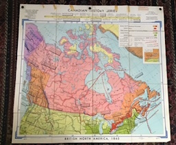
British North America 1865 (Map)
Editore: Denoyer-Geppert Company, Chicago, 1968
Da: Harry E Bagley Books, Fredericton, NB, Canada
Valutazione del venditore 2 su 5 stelle
Mappa
EUR 84,22
Spedizione EUR 25,82
Spedito da Canada a U.S.A.Quantit�: 1 disponibili
Aggiungi al carrelloSoft cover. Condizione: Very Good. large full color linen-backed wall map, measuring 401/2 x 431/2 inches,(509.27 x 547.37 cm) from the Canadian History Series by Denoyer-Geppert Company, Chicago, its main topics being; Exploration, 1800-1865;Economic Developments; (a) Extent of Settlement, 1865,(b) Railways and Canals; (c) Trade Routes: Political Developments: Boundaries (a) With the United States. (b) With Russian America. very good condition with some minor tape repairs at top edge, 3 eyelets for hanging, folds into a blue cloth cover. Map no 9 in series of maps produced for schools. Map.
-
![Immagine del venditore per Map, globes, pictures and charts for effective geography and history teaching. Volume yr. 1922 [LeatherBound] venduto da S N Books World](https://pictures.abebooks.com/inventory/md/md30638762317.jpg)
Map, globes, pictures and charts for effective geography and history teaching. Volume yr. 1922 [LeatherBound]
Lingua: Inglese
Data di pubblicazione: 2025
EUR 28,36
Spedizione gratuita
Spedito da India a U.S.A.Quantit�: 18 disponibili
Aggiungi al carrelloLeatherbound. Condizione: NEW. BOOKS ARE EXEMPT FROM IMPORT DUTIES AND TARIFFS; NO EXTRA CHARGES APPLY. Leatherbound edition. Condition: New. Leather Binding on Spine and Corners with Golden leaf printing on spine. Bound in genuine leather with Satin ribbon page markers and Spine with raised gilt bands. Pages: 380. A perfect gift for your loved ones. Reprinted from edition. NO changes have been made to the original text. This is NOT a retyped or an ocr'd reprint. Illustrations, Index, if any, are included in black and white. Each page is checked manually before printing. As this print on demand book is reprinted from a very old book, there could be some missing or flawed pages, but we always try to make the book as complete as possible. Fold-outs, if any, are not part of the book. If the original book was published in multiple volumes then this reprint is of only one volume, not the whole set. IF YOU WISH TO ORDER PARTICULAR VOLUME OR ALL THE VOLUMES YOU CAN CONTACT US. Resized as per current standards. Sewing binding for longer life, where the book block is actually sewn (smythe sewn/section sewn) with thread before binding which results in a more durable type of binding. Volume yr. 1922 Language: English Pages: 380 Volume yr. 1922.
-
Europe; physical-political (Large Pull Down Map)
Editore: Denoyer-Geppert Company,, 1941
Da: Sequitur Books, Boonsboro, MD, U.S.A.
Membro dell'associazione: IOBA
Valutazione del venditore 5 su 5 stelle
Hardcover. Condizione: Fair. [Pre-WWII Europe] 160 x 185 cm. Color map, mounted on muslin, rods top and bottom. Heavy metal rolling rod at top. Scale 50 miles to the inch. S2 Europe map. Bottom rod partial separated / torn from map. Note: This is a large, heavy map. Additional postage will apply depending on delivery location.
-
Westward Movement and War of 1812 (Large Pull Down Map)
Editore: Denoyer-Geppert Company, 1960
Da: Sequitur Books, Boonsboro, MD, U.S.A.
Membro dell'associazione: IOBA
Valutazione del venditore 5 su 5 stelle
Mappa
Maps. Condizione: Very Good. 2 maps on one sheet. 90 x 111 cm. Mounted on muslin and fitted with rodsRelief shown by gradient tints. Contents:1763-1803; 1803-1829. Scale ca. 1:3,198,000. Inset: Naval engagements, War of 1812. Denoyer-Geppert social science maps, A10. Note: This is a large, heavy map. Additional postage will apply depending on delivery location.
-
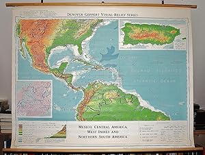
Mexico, Central America, West Indies and Northern South America (Large Pull Down Map)
Editore: Denoyer-Geppert Co., Chicago, 1961
Da: Sequitur Books, Boonsboro, MD, U.S.A.
Membro dell'associazione: IOBA
Valutazione del venditore 5 su 5 stelle
Mappa
Maps. Condizione: Very Good. 107 x 136 cm. Mounted on muslin and fitted with rods. Light fray at top left corner where map connects to wooden rod. Relief shown by shading, gradient tints and spot heights. Insets: Puerto Rico -- Panama Canal ZoneEnglish and Spanish. Denoyer-Geppert visual-relief series, Map S567vr. Scale 1:7,200,000. Note: This is a large, heavy map. Additional postage will apply depending on delivery location.
-
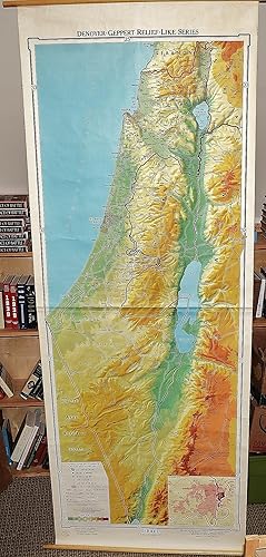
Israel: Denoyer-Geppert Relief-Like Series (Large Pull Down Map)
Editore: Denoyer-Geppert, Chicago, 1966
Da: Sequitur Books, Boonsboro, MD, U.S.A.
Membro dell'associazione: IOBA
Valutazione del venditore 5 su 5 stelle
Mappa
Maps. Condizione: Good. 241 x 88 cm. Large wall map, with wooden rods, top and bottom. Creasing. scale 1: 750 000. Relief shown by gradient tints and shading. Includes inset of Jerusalem and vicinity. "Map RL312. Relief-like Israel." Scale approximately 1:200,000, (E 34--15'--E 35--45'/N 33--15'--N 29--30'). Relief map of Israel showing international boundaries, highways, railroads, antiquity and religious sites and populated places. Relief shown by hypsometric tints and spot heights. Note: This is a large, heavy map. Additional postage will apply depending on delivery location.
-
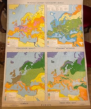
Europe
Editore: Denoyer Geppert, Chicago, 1968
Da: Argosy Book Store, ABAA, ILAB, New York, NY, U.S.A.
Membro dell'associazione: ABAA ILAB
Valutazione del venditore 5 su 5 stelle
Roller map. Includes original hanging bracket. Measures 56 1/2" x 43 1/2" Colorful school map featuring four maps of Europe depicting population density, economic activities, climate types, and frost-free days. In very good condition, with some wear to bottom left and minor scuffing. Denoyer-Geppert was formed in Chicago in the early 20th century as a purveyor of maps and globes. In the post-war period, they concentrated their production on educational tools. They gained acclaim and popularity in the 1960s when their Cartograph Globe appeared alongside Apollo astronauts in publicity photographs for NASA's burgeoning space program. Over the next decades, Denoyer-Geppert developed a robust selection of innovative scientific products used in fields as disparate as anatomy and chemistry. This map is a fascinating example of their work.
-
South America. Wenschow Relief-Like Map. (Large pull down color map)
Editore: Denoyer-Geppert, Chicago, 1963
Da: Sequitur Books, Boonsboro, MD, U.S.A.
Membro dell'associazione: IOBA
Valutazione del venditore 5 su 5 stelle
Mappa
Maps. Condizione: Very Good. 6th. Mounted on muslin, wood rods top and bottom. 153 x 184 cm. Scale 1:6 000 000. "Map RL6" Relief shown by shading, gradient tints and spot heights. Depths shown by gradient tints and spot soundings. Note: This is a large, heavy map. Additional postage will apply depending on delivery location.
-
Lines of Transportation. (map)
Editore: Denoyer-Geppert Social Science Maps, Chicago, 1963
Da: Harry E Bagley Books, Fredericton, NB, Canada
Valutazione del venditore 2 su 5 stelle
EUR 177,31
Spedizione EUR 25,82
Spedito da Canada a U.S.A.Quantit�: 1 disponibili
Aggiungi al carrelloNo Binding. Condizione: Very Good. 1 map : color ; 69 x 105 cm, folded to 42 x 28 cm., showing transport routes America wide.(main lines and secondary routes, divided in sections and laid on canvas, eyelets for hanging, very good condition,Scale [ca. 1:4,500,000] Denoyer-Geppert social science maps, A19. Book.
-
Asia Commercial Development (Large Pull Down Map)
Editore: G. Philip & Son, London, 1940
Da: Sequitur Books, Boonsboro, MD, U.S.A.
Membro dell'associazione: IOBA
Valutazione del venditore 5 su 5 stelle
Mappa
Maps. Condizione: Very Good. Large color map. Includes commodities of Asia (opium among other things listed). 88 x 112 cm. Mounted on muslin, wood rods top and bottom. Hanging hooks not included. 1:12,000,000 (approximately 200 miles= 1 inch) ;, Bonne's projection. Note: This is a large, heavy map. Additional postage will apply depending on delivery location.
-
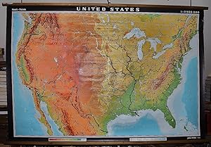
The United States (Large Pull Down Map)
Editore: Hermann Haack Geographisch-Kartographische Anstalt Gotha, 1964
Da: Sequitur Books, Boonsboro, MD, U.S.A.
Membro dell'associazione: IOBA
Valutazione del venditore 5 su 5 stelle
Mappa
Maps. Condizione: Very Good. Large physical map of the United States, with state boundaries, capitals and principal cities. 132 x 198 cm. Mounted on muslin, wood rods top and bottom. Small tear, crumbled edge on right outer margin. Scale, 1:2,500,000. Denoyer-Geppert no. 15501. Note: This is a large, heavy map. Additional postage will apply depending on delivery location.
-
Japan (Large Pull Down Map)
Editore: Denoyer-Geppert Co., Chicago, Ill., 1972
Da: Sequitur Books, Boonsboro, MD, U.S.A.
Membro dell'associazione: IOBA
Valutazione del venditore 5 su 5 stelle
Mappa
Maps. Condizione: Very Good. 158 x 110 cm. Large wall map, with wooden rods, top and bottom. Contents: Japan; Average annual rainfall; Population density; Land utilization; Japan, its relative position; Major administrative areas. Denoyer-Geppert visual-relief series, J313 vr. Note: This is a large, heavy map. Additional postage will apply depending on delivery location.
-
Europe (Large Pull Down Map)
Editore: Denoyer Geppert Co., Chicago, 1939
Da: Sequitur Books, Boonsboro, MD, U.S.A.
Membro dell'associazione: IOBA
Valutazione del venditore 5 su 5 stelle
Mappa
Maps. Condizione: Good. [WWII era Map of Europe, with the German Reich's borders including Austria, Poland is separated into two parts but still listed as a country] 162 x 188 cm. Color map, mounted on muslin, wood rods top and bottom. Some fraying at outer edge where the top wooden rod connects with the map. Scale 1:4,700,000; Simple conic projection. Note: This is a large, heavy map. Additional postage will apply depending on delivery location.
-
Successful teaching with globes : a teacher's manual for use with Denoyer-Geppert Globes / prepared and edited in the Editorial Dept. of the Denoyer-Geppert Company, under the general direction of Clarence B. Odell, managing editor. 1957 [Leather Bound]
Data di pubblicazione: 2025
Da: Gyan Books Pvt. Ltd., Delhi, India
Valutazione del venditore 5 su 5 stelle
EUR 28,97
Spedizione gratuita
Spedito da India a U.S.A.Quantit�: Pi� di 20 disponibili
Aggiungi al carrelloLeather Bound. Condizione: New. Language: English. Language: English. Presenting an Exquisite Leather-Bound Edition, expertly crafted with Original Natural Leather that gracefully adorns the spine and corners. The allure continues with Golden Leaf Printing that adds a touch of elegance, while Hand Embossing on the rounded spine lends an artistic flair. This masterpiece has been meticulously reprinted in 2025, utilizing the invaluable guidance of the original edition published many years ago in 1957. The contents of this book are presented in classic black and white. Its durability is ensured through a meticulous sewing binding technique, enhancing its longevity. Imprinted on top-tier quality paper. A team of professionals has expertly processed each page, delicately preserving its content without alteration. Due to the vintage nature of these books, every page has been manually restored for legibility. However, in certain instances, occasional blurriness, missing segments, or faint black spots might persist. We sincerely hope for your understanding of the challenges we faced with these books. Recognizing their significance for readers seeking insight into our historical treasure, we've diligently restored and reissued them. Our intention is to offer this valuable resource once again. We eagerly await your feedback, hoping that you'll find it appealing and will generously share your thoughts and recommendations. Lang: - English, Pages:- 52, Print on Demand. If it is a multi-volume set, then it is only a single volume. We are specialised in Customisation of books, if you wish to opt different color leather binding, you may contact us. This service is chargeable. Product Disclaimer: Kindly be informed that, owing to the inherent nature of leather as a natural material, minor discolorations or textural variations may be perceptible. Explore the FOLIO EDITION (12x19 Inches): Available Upon Request. 52 52.
-

Ratification of the Constitution A. 1787-1790, B. State Claims 1776-1802
Data di pubblicazione: 1964
Da: Art Source International Inc., Boulder, CO, U.S.A.
Valutazione del venditore 5 su 5 stelle
This large wall map is a great educational map published by Denoyer-Geppert for its Social Science Maps collection in 1964. Brightly colored and easy to read, this map of the states ratified in the Constitution is divided into two parts: A. 1787-1790, B. State Claims in 1776-1802. An inset of the boundary adjustments in 1780-1800 is included. The colors indicate the first six states, states completing union, belated states, and post constitutional states with dates of each. This map measures 42.25 inches by 30 inches.
-

International Rivalries A. 1580-1662, B. 1662-1750
Data di pubblicazione: 1963
Da: Art Source International Inc., Boulder, CO, U.S.A.
Valutazione del venditore 5 su 5 stelle
This large wall map is a great educational map published by Denoyer-Geppert for its Social Science Maps collection in 1963. Brightly colored and easy to read, this map showing the international rivalries, divided into two maps of A. 1580-1662 and B. 1662-1750. Details include the trails and routes of various explorers with their dates. Two small inset maps are of the English-Swedish-Dutch Controversy and Six Nations. This map measures 40.25 inches by 30 inches.
-

Western Statehood and Land Grants to Railroads
Data di pubblicazione: 1963
Da: Art Source International Inc., Boulder, CO, U.S.A.
Valutazione del venditore 5 su 5 stelle
This large wall map is a great educational map published by Denoyer-Geppert for its Social Science Maps collection in 1963. Brightly colored and easy to read, this map of the United States shows the western statehood and land grants to railroads. Details include Indian reservations, federal grants to states, corporations, and forfeited grants. This map measures 42.25 inches by 30 inches.
-

English Colonial Grants in 1589-1660, and 1660-1763
Data di pubblicazione: 1963
Da: Art Source International Inc., Boulder, CO, U.S.A.
Valutazione del venditore 5 su 5 stelle
This large wall map is a great educational map published by Denoyer-Geppert for its Social Science Maps collection in 1963. Brightly colored and easy to read, this map of the eastern United States during the English Colonial Grants, divided into maps: A. 1580-1660, B. 1660-1763. Insets of the Virginia Claims and the New England Confederation, 1643-1684. Details include claims by charter with dates, various cities, and dates on states when grants were given. This map measures 42.5 inches by 30 inches.
-

A8 Revolutionary War 1775-1783
Data di pubblicazione: 1963
Da: Art Source International Inc., Boulder, CO, U.S.A.
Valutazione del venditore 5 su 5 stelle
This large wall map is a great educational map published by Denoyer-Geppert for its Social Science Maps collection in 1963. Brightly colored and easy to read, this map of the Revolutionary War during 1775-1783 has several small maps showing the different campaigns including: Virginia Campaign 1781, Central Campaigns 1776-1778, Saratoga Campaign 1777, Newport 1778, Operations Near Boston. Details include the routes of the American and British forces. This map measures 42.25 inches by 30 inches.
-

Secession 1860-1861
Data di pubblicazione: 1963
Da: Art Source International Inc., Boulder, CO, U.S.A.
Valutazione del venditore 5 su 5 stelle
This large wall map is a great educational map published by Denoyer-Geppert for its Social Science Maps collection in 1963. Brightly colored and easy to read, this map of the United States during secession in 1860-1861. The colored portions shows the free states, free territories, loyal slave states, forts seized by seceding forces, and more. An inset of Charleston Harbor is included. This map measures 42.5 inches by 30 inches.
-

Land and Water Routes 1829-1860
Data di pubblicazione: 1963
Da: Art Source International Inc., Boulder, CO, U.S.A.
Valutazione del venditore 5 su 5 stelle
This large wall map is a great educational map published by Denoyer-Geppert for its Social Science Maps collection in 1963. Brightly colored and easy to read, this map of the United States shows the land and water routes during 1829-1860. Topographic features of mountain ranges, rivers, and colored sections showing height of land in feet are shown. Details include railroads, canals, water routes. The routes listed are the Santa Fe, Mormon, Oregon, Fremont, Pony. California, and Bonneville trails. This map measures 42.5 inches by 30 inches.
-

Civil War, Insets of Visckburg Campaign; Virginia Campaign; Atlanta Campaign
Data di pubblicazione: 1963
Da: Art Source International Inc., Boulder, CO, U.S.A.
Valutazione del venditore 5 su 5 stelle
This large wall map is a great educational map published by Denoyer-Geppert for its Social Science Maps collection in 1963. Brightly colored and easy to read, this map of Eastern United States during the Civil War. The map is divided into colored sections of the free states at outbreak of war, free acts of Congress 1862, free by Emancipation Proclamation 1863, slave area not affection by Proclamation, lines of Federal Military occupation, area of Confederate Military control. Routes of the Confederate and Federal are shown along with raided and Federal blockade. Insets of the Vicksburg Campaign 1863, Virginia and Atlanta Campaigns. This map measures 42 inches by 30 inches.
-

Abolition, Cotton Production, Reconstruction, Per Capita Wealth
Data di pubblicazione: 1963
Da: Art Source International Inc., Boulder, CO, U.S.A.
Valutazione del venditore 5 su 5 stelle
This large wall map is a great educational map published by Denoyer-Geppert for its Social Science Maps collection in 1963. Brightly colored and easy to read, this map consists of four separate maps of: Abolition, Reconstruction - Conservative Government Reinstated, Cotton Production - 1869 as compared with 1859, and Per Capita Wealth - 1870 as compared with 1860. This map measures 41.75 inches by 30 inches.


![Immagine del venditore per Successful teaching with globes : a teacher's manual for use with Denoyer-Geppert Globes / prepared and edited in the Editorial Dept. of the Denoyer-Geppert Company, under the general direction of Clarence B. Odell, managing editor. 1957 [Leather Bound] venduto da Gyan Books Pvt. Ltd.](https://pictures.abebooks.com/inventory/md/md30658509125.jpg)