Importo totale (1 articolo articoli):
Destinazione ordine:

dripps mathew (3 risultati)
Vai alla pagina principale dei risultati di ricerca
Filtri di ricerca
Tipo di articolo
- Tutti i tipi di prodotto
- Libri (3)
- Riviste e Giornali (Nessun altro risultato corrispondente a questo perfezionamento)
- Fumetti (Nessun altro risultato corrispondente a questo perfezionamento)
- Spartiti (Nessun altro risultato corrispondente a questo perfezionamento)
- Arte, Stampe e Poster (Nessun altro risultato corrispondente a questo perfezionamento)
- Fotografie (Nessun altro risultato corrispondente a questo perfezionamento)
- Mappe (Nessun altro risultato corrispondente a questo perfezionamento)
- Manoscritti e Collezionismo cartaceo (Nessun altro risultato corrispondente a questo perfezionamento)
Condizioni Maggiori informazioni
- Nuovo (Nessun altro risultato corrispondente a questo perfezionamento)
- Come nuovo, Ottimo o Quasi ottimo (Nessun altro risultato corrispondente a questo perfezionamento)
- Molto buono o Buono (Nessun altro risultato corrispondente a questo perfezionamento)
- Discreto o Mediocre (Nessun altro risultato corrispondente a questo perfezionamento)
- Come descritto (3)
Legatura
- Tutte
- Rilegato (Nessun altro risultato corrispondente a questo perfezionamento)
- Brossura (Nessun altro risultato corrispondente a questo perfezionamento)
Ulteriori caratteristiche
- Prima ed. (Nessun altro risultato corrispondente a questo perfezionamento)
- Copia autograf. (Nessun altro risultato corrispondente a questo perfezionamento)
- Sovracoperta (Nessun altro risultato corrispondente a questo perfezionamento)
- Con foto (3)
- Non Print on Demand (3)
Lingua (2)
Prezzo
- Qualsiasi prezzo
- Inferiore a EUR 20 (Nessun altro risultato corrispondente a questo perfezionamento)
- EUR 20 a EUR 45 (Nessun altro risultato corrispondente a questo perfezionamento)
- Superiore a EUR 45
Spedizione gratuita
- Spedizione gratuita in U.S.A. (Nessun altro risultato corrispondente a questo perfezionamento)
Paese del venditore
Valutazione venditore
-
Map of New York and Vicinity
Lingua: Inglese
Editore: Valentine, New York, 1865
Da: Argosy Book Store, ABAA, ILAB, New York, NY, U.S.A.
Membro dell'associazione: ABAA ILAB
Valutazione del venditore 5 su 5 stelle

Map. Hand-colored lithograph. 33.5 x 20.5". This fantastic and rare map of New York City and its surrounding areas was originally prepared for the 1865 edition Valentine's "Manual of the Corporation of the City of New York," a richly illustrated collection of facts and statistics related to the city. It depicts Manhattan Island at the center from the Battery up to 132nd St. Around Manhattan are the waterfront areas of Brooklyn, Astoria, Hoboken and Jersey City. The map owes its wonderfully graphic quality to its vertical orientation, precise grid and finely shaded sections of the city. Of note is a striking rendering of Central Park, hand-colored in green and blue to convey the park's organic beauty within the regular geometry of the city streets. Early repair upper left, otherwise, the map is in very good condition, with only minor foxing and slightly torn edges. Mathew Dripps (-1896) was from Ireland and a prominent cartographer remembered most for his maps of New York City. David Thomas Valentine (1801-1869) served as the Deputy to the Clerk of the Common Council for thirty-seven years and began publishing the "Manual for the Corporation of the City of New York" in 1841. The Manuals were directories of extensive historical and contemporary records of New York that included facts about the City of New York, city history, city council information, and reported on the progress of public works such as Central Park. Popularly called Valentine's Manuals, the texts were richly illustrated with maps, lithographs, and engravings. . This beautifully composed map would be an outstanding addition to any collection or home.
-
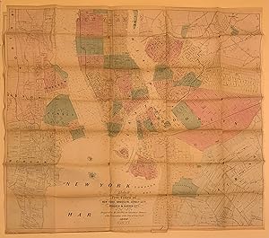
Map of the city of New York with street directory showing house-numbers, hotels, churches, banks, theatres, ferries, horse-car, steam and elevated R.R'ds, &c
Editore: M. Dripps, 111 Fulton St., n.d., New York, 1880
Da: Rulon-Miller Books (ABAA / ILAB), St. Paul, MN, U.S.A.
Membro dell'associazione: ABAA ILAB RMABA
Valutazione del venditore 5 su 5 stelle
Folding pocket map approx. 28" x 20", folding down to 5�" x 3�" and contained in a brown cloth binding lettered in gilt; map is handcolored in pink, green, and yellow; several minor breaks at the folds but generally a very good copy. Bookseller's ticket of "Paul Grosse, stationer, 541 Fulton St. near Gold, Brooklyn." Advertisement slip "Catalogue of M. Dripp's Maps" tipped to the front endpaper. This map is not listed in the catalogue.
-
Map of the Five Cities of New York, Brooklyn, Jersey City, Hoboken and Hudson City
Editore: Valentine, New York, 1860
Da: Argosy Book Store, ABAA, ILAB, New York, NY, U.S.A.
Membro dell'associazione: ABAA ILAB
Valutazione del venditore 5 su 5 stelle
Map. Hand-colored lithograph. 39.5" x 28", (set of 2). New York: D. T. Valentine (1860). This fantastic large scale set of two maps of New York City and its surrounding areas was originally prepared for the 1860 edition Valentine's "Manual of the Corporation of the City of New York," a richly illustrated collection of facts and statistics related to the city. It depicts Manhattan Island at the center from the Battery up to lower Westchester and the Bronx. Around Manhattan are the waterfront areas of Brooklyn, Astoria, Hoboken and Jersey City. Overlaying the grid are the names and tracts of Manhattan's original land owners, as well as scattered individual buildings. Wards are in color and there are ferry routes, depths in sounding and a 'proposed prospect park' in Brooklyn. Printed in two sheets, Original folds as issued, with some wear along folds but otherwise in very good condition, can be joined into one large map. Must be seen to be appreciated. Mathew Dripps was from Ireland. He became a prominent map publisher based in lower Manhattan and is remembered most for his maps of New York City. His maps are hard to find.