Dyonnet ch (87 risultati)

Editore: IMP. MIGEON
- Mappa
Da: Le-Livre, SABLONS, , FranciaLe-Livre
Contatta il venditoreVenditore con 5 stelleCondizione: Usato - Quasi ottimo
EUR 16,95
EUR 42,00 spedizioneSpedito da Francia a U.S.A.Quantità: 2 disponibili
Pas de couverture. Condizione: bon. RO80091063: XIXe siècle. In-4. En feuillets. Bon état, Livré sans Couverture, Dos satisfaisant, Intérieur acceptable. Une planche ( de 34.5 x 26.5 cm) illustrée d'une carte en couleurs et de quelques gravures en noir et blanc. . . . Classification Dewey : 912-Atlas, cartes et plans.

Editore: IMP. MIGEON
- Mappa
Da: Le-Livre, SABLONS, , FranciaLe-Livre
Contatta il venditoreVenditore con 5 stelleCondizione: Usato - Quasi ottimo
EUR 16,95
EUR 42,00 spedizioneSpedito da Francia a U.S.A.Quantità: 1 disponibili
Pas de couverture. Condizione: bon. RO80091074: XIXe siècle. In-4. En feuillets. Bon état, Livré sans Couverture, Dos satisfaisant, Intérieur acceptable. Une planche ( de 34.5 x 26.5 cm) illustrée d'une carte en couleurs et de quelques gravures en noir et blanc. . . . Classification Dewey : 912-Atlas, cartes et plans.

Editore: IMP. MIGEON
- Mappa
Da: Le-Livre, SABLONS, , FranciaLe-Livre
Contatta il venditoreVenditore con 5 stelleCondizione: Usato - Quasi ottimo
EUR 16,95
EUR 42,00 spedizioneSpedito da Francia a U.S.A.Quantità: 1 disponibili
Pas de couverture. Condizione: bon. RO80091056: XIXe siècle. In-4. En feuillets. Bon état, Livré sans Couverture, Dos satisfaisant, Intérieur acceptable. Une planche (34.5 x 26.5 cm) illustrée d'une carte en couleurs et de quelques gravures en noir et blanc. . . A l'italienne. Classification Dewey : 912-Atlas, cartes et plans.

Editore: IMP. MIGEON
- Mappa
Da: Le-Livre, SABLONS, , FranciaLe-Livre
Contatta il venditoreVenditore con 5 stelleCondizione: Usato - Quasi ottimo
EUR 16,95
EUR 42,00 spedizioneSpedito da Francia a U.S.A.Quantità: 1 disponibili
Pas de couverture. Condizione: bon. RO80091066: XIXe siècle. In-4. En feuillets. Bon état, Livré sans Couverture, Dos satisfaisant, Intérieur acceptable. Une planche ( de 34.5 x 26.5 cm) illustrée d'une carte en couleurs et de quelques gravures en noir et blanc. . . A l'italienne. Classification Dewey : 912-Atlas, cartes et plan…s.

Editore: IMP. MIGEON XIXe siècle
- Mappa
Da: Le-Livre, SABLONS, , FranciaLe-Livre
Contatta il venditoreVenditore con 5 stelleCondizione: Usato - Quasi ottimo
EUR 16,95
EUR 42,00 spedizioneSpedito da Francia a U.S.A.Quantità: 1 disponibili
Pas de couverture. Condizione: bon. RO80091046: XIXe siècle. In-4. En feuillets. Etat d'usage, Livré sans Couverture, Dos satisfaisant, Intérieur acceptable. Une planche (34.5 x 23 cm) illustrée d'une carte en couleurs et de quelques gravures en noir et blanc. . . . A l'italienne. Classification Dewey : 912-Atlas, cartes et plan…s.

Editore: IMP. MIGEON
- Mappa
Da: Le-Livre, SABLONS, , FranciaLe-Livre
Contatta il venditoreVenditore con 5 stelleCondizione: Usato - Quasi ottimo
EUR 16,95
EUR 42,00 spedizioneSpedito da Francia a U.S.A.Quantità: 1 disponibili
Pas de couverture. Condizione: bon. RO80091109: XIXe siècle. In-4. En feuillets. Bon état, Livré sans Couverture, Dos satisfaisant, Intérieur acceptable. Une planche ( de 34.5 x 26.5 cm) illustrée d'une carte en couleurs et de quelques gravures en noir et blanc. . . A l'italienne. Classification Dewey : 912-Atlas, cartes et plan…s.

Editore: IMP. MIGEON
- Mappa
Da: Le-Livre, SABLONS, , FranciaLe-Livre
Contatta il venditoreVenditore con 5 stelleCondizione: Usato - Quasi ottimo
EUR 16,95
EUR 42,00 spedizioneSpedito da Francia a U.S.A.Quantità: 1 disponibili
Pas de couverture. Condizione: bon. RO80091075: XIXe siècle. In-4. En feuillets. Bon état, Livré sans Couverture, Dos satisfaisant, Intérieur acceptable. Une planche ( de 34.5 x 26.5 cm) illustrée d'une carte en couleurs et de quelques gravures en noir et blanc. . . . Classification Dewey : 912-Atlas, cartes et plans.

Editore: IMP. MIGEON
- Mappa
Da: Le-Livre, SABLONS, , FranciaLe-Livre
Contatta il venditoreVenditore con 5 stelleCondizione: Usato - Quasi ottimo
EUR 16,95
EUR 42,00 spedizioneSpedito da Francia a U.S.A.Quantità: 1 disponibili
Pas de couverture. Condizione: bon. RO80091051: XIXe siècle. In-4. En feuillets. Bon état, Livré sans Couverture, Dos satisfaisant, Intérieur acceptable. Une planche (34.5 x 26.5 cm) illustrée d'une carte en couleurs et de quelques gravures en noir et blanc. . . . Classification Dewey : 912-Atlas, cartes et plans.

Editore: IMP. MIGEON
- Mappa
Da: Le-Livre, SABLONS, , FranciaLe-Livre
Contatta il venditoreVenditore con 5 stelleCondizione: Usato - Quasi ottimo
EUR 16,95
EUR 42,00 spedizioneSpedito da Francia a U.S.A.Quantità: 1 disponibili
Pas de couverture. Condizione: bon. RO80091069: XIXe siècle. In-4. En feuillets. Bon état, Livré sans Couverture, Dos satisfaisant, Intérieur acceptable. Une planche ( de 34.5 x 26.5 cm) illustrée d'une carte en couleurs et de quelques gravures en noir et blanc. . . A l'italienne. Classification Dewey : 912-Atlas, cartes et plan…s.

Editore: IMP. MIGEON
- Mappa
Da: Le-Livre, SABLONS, , FranciaLe-Livre
Contatta il venditoreVenditore con 5 stelleCondizione: Usato - Quasi ottimo
EUR 16,95
EUR 42,00 spedizioneSpedito da Francia a U.S.A.Quantità: 1 disponibili
Pas de couverture. Condizione: bon. RO80091070: XIXe siècle. In-4. En feuillets. Bon état, Livré sans Couverture, Dos satisfaisant, Intérieur acceptable. Une planche ( de 34.5 x 26.5 cm) illustrée d'une carte en couleurs et de quelques gravures en noir et blanc. . . . Classification Dewey : 912-Atlas, cartes et plans.
 Altre immagini
Lingua: Francese
Editore: Furne, Jouvet et Cie 1860
- Rilegato
- Prima edizione
Da: Librairie du Cardinal, GRADIGNAN, , FranciaLibrairie du Cardinal
Contatta il venditoreVenditore con 5 stelleCondizione: Usato - Quasi ottimo
EUR 150,00
EUR 25,00 spedizioneSpedito da Francia a U.S.A.Quantità: 1 disponibili
rigide. Condizione: Bon. Dressé par Th. Duvotenay, gravé par Ch. Dyonnet, 1 vol. in-4 (29,5 x 24,5 cm) cartonnage éditeur demi-percaline verte, Furne, Jouvet et Cie, Paris, s.d. [ circa 1860 ], 2 ff. et 32 cartes Bon exemplaire (très petits frott., notamment en coins) Langue: Français.
 Altre immagini
Lingua: Francese
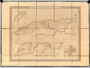
Editore: Chez Hyacinthe Langlois 1844
- Brossura
- Prima edizione
- Mappa
Da: Librairie du Cardinal, GRADIGNAN, , FranciaLibrairie du Cardinal
Contatta il venditoreVenditore con 5 stelleCondizione: Usato - Quasi ottimo
EUR 395,00
EUR 25,00 spedizioneSpedito da Francia a U.S.A.Quantità: 1 disponibili
souple. Condizione: Bon. Carte dépliante entoilée format 79,5 x 58 cm, gravé par Dyonnet, Chez Hyacinthe Langlois, 4 rue du Pot de Feu St Sulpice, "Carte de France d'après Cassini", s.d. [ 1844 ] Jolie carte ancienne de l'Algérie rehaussée en couleurs. On y découvre en encart les "Environs d'Alger" ou "l'Empire de Maroc". Bon ét…at (petit accroc en marge entoilée, petits frott.) Langue: Français.

Editore: [Paris: French Publisher], circa 1879. 1879
- Stampa artistica
Da: Wittenborn Art Books, San Francisco, CA, U.S.A.Wittenborn Art Books
Contatta il venditoreVenditore con 5 stelleCondizione: Usato - Buono
EUR 66,54
EUR 8,61 spedizioneSpedito in U.S.A.Quantità: 1 disponibili
Condizione: Good. Colored Map. 27 x 35.5 cm. (sheet). Very Good, some toning along sheet edges.
 Altre immagini
Editore: Librairie des Publications Illustrées 1854
- Rilegato
Da: Librairie de la Garenne, CLICHY, FranciaLibrairie de la Garenne
Contatta il venditoreVenditore con 5 stelleCondizione: Usato - Ottimo
EUR 100,00
EUR 37,00 spedizioneSpedito da Francia a U.S.A.Quantità: 1 disponibili
Couverture rigide. Condizione: Très bon. petit in-4 rel. 1/2 toile (21 X 28), n.p., 32 cartes montées sur onglet, reliure entièrement restaurée (dos toilé, couvrure des plats, gardes récents), titrage conservé sur le premier plat, mention manuscrite sur la page de faux-titre, exemplaire bien complet, très bon état. Wattignies -…Toulon - Nerwinde - Hollande - Fleurus - Piémon et Lombardie 1796 - 1800 - Montenotte, Millesimo - Mantoue, St-Georges-La-Favorite - Strasbourg - Italie - Castiglione - Arcole - Rivoli - Entre Pô et Danube - Venise - Malte - Egypte et Syrie - Les Pyramides - Aboukir - Mont-Thabor - Suisse - Zürich.

Editore: FURNE et Cie.
- Rilegato
- Mappa
Da: Le-Livre, SABLONS, , FranciaLe-Livre
Contatta il venditoreVenditore con 5 stelleCondizione: Usato - Quasi ottimo
EUR 155,00
EUR 42,00 spedizioneSpedito da Francia a U.S.A.Quantità: 1 disponibili
Couverture rigide. Condizione: bon. RO80123548: Non daté. In-Folio. Relié demi-cuir. Etat passable, Couv. défraîchie, Dos satisfaisant, Mouillures. 32 planches de cartes en noir et blanc. Quelques déchirures sur la 1ère carte. Coiffes abîmées. . . . Classification Dewey : 912-Atlas, cartes et plans.

Editore: FURNE et Cie. 1846
- Rilegato
- Mappa
Da: Le-Livre, SABLONS, , FranciaLe-Livre
Contatta il venditoreVenditore con 5 stelleCondizione: Usato - Quasi ottimo
EUR 255,00
EUR 42,00 spedizioneSpedito da Francia a U.S.A.Quantità: 1 disponibili
Couverture rigide. Condizione: bon. RO80102051: 1846. In-Folio. Relié. Etat d'usage, Couv. défraîchie, Dos satisfaisant, Rousseurs. 32 planches collationnées de cartes en noir et blanc. Ouvrage déboité, cahier se détachant. Coins et coupes des plats frottés. . . . Classification Dewey : 912-Atlas, cartes et plans.
 Altre immagini
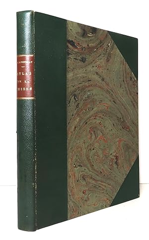
Editore: Paris, Delloye, 1837
- Rilegato
Da: La Bergerie, Le Locle, SvizzeraLa Bergerie
Contatta il venditoreVenditore con 5 stelleCondizione: Usato - Buono
EUR 279,61
EUR 47,10 spedizioneSpedito da Svizzera a U.S.A.Quantità: 1 disponibili
Couverture rigide. Condizione: Satisfaisant. In-4, demi-maroquin vert à coins, dos lisse, pièce de titre. Légers frottements à la reliure, importantes rousseurs, courant sur tout le volume, tache rose à la page de titre - en l'état. Bien complet des 21 cartes (dont certaines doubles), de la carte de la Suisse en couleurs et des…22 vues, gravées sur acier par Dyonnet.

- Mappa
Da: Le-Livre, SABLONS, , FranciaLe-Livre
Contatta il venditoreVenditore con 5 stelleCondizione: Usato - Quasi ottimo
EUR 16,95
EUR 42,00 spedizioneSpedito da Francia a U.S.A.Quantità: 1 disponibili
Pas de couverture. Condizione: bon. RO80117546: Non daté. In-4. En feuillets. Bon état, Livré sans Couverture, Dos satisfaisant, Intérieur acceptable. Une carte gravée en couleurs, en planche de 35 x 26 cm. Avec quelques figures gravées en noir et blanc, autour. . . . Classification Dewey : 912-Atlas, cartes et plans.

Editore: Paris 1859, (Paulin)
Da: Antiquariat Cellensia, Celle, , GermaniaAntiquariat Cellensia
Contatta il venditoreVenditore con 4 stelleCondizione: Usato
EUR 30,00
EUR 60,00 spedizioneSpedito da Germania a U.S.A.Quantità: 1 disponibili
Stahlstich. Blatt: 27 x 43 cm. Karte zeigt die gegend um Eylau vonSchmoditten nach Rothenen. Aus: Adolphe Thiers - Atlas de l Histoire du Consulat et de l Empire.
Editore: Paris 1859, (Paulin)
Da: Antiquariat Cellensia, Celle, , GermaniaAntiquariat Cellensia
Contatta il venditoreVenditore con 4 stelleCondizione: Usato
EUR 30,00
EUR 60,00 spedizioneSpedito da Germania a U.S.A.Quantità: 1 disponibili
Stahlstich. 27 x 43,5 cm. - Karte der Ungebung von Friedland im Jahre 1807. Aus: Adolphe Thiers, Atlas de l Histoire du Consulat et de l Empire. Umfaßt die Gegend von Schwönau, Karschau, Pluckheim, Bamblen, Kloschenen, Friedland, Allenau, Sortlack, Posthenen, Georgenau, und Heinrichsdorf.

Lingua: Francese
Editore: Depot des Cartes et Plans de la Marine, Paris 1875
- Mappa
Da: FOLIOS LIMITED, Oxford, Regno UnitoFOLIOS LIMITED
Contatta il venditoreVenditore con 5 stelleCondizione: Usato - Buono
EUR 89,33
EUR 40,47 spedizioneSpedito da Regno Unito a U.S.A.Quantità: 1 disponibili
No Binding. Condizione: Good. Engraved chart on vellum double sheet, 91 x 62 cm, engraved by Ch. Dyonnet, la Teinte par Naudin, Nyon, written by F. Lefevre, drawn in 1870 by E. Mouchez, small smudge on left margin, small stamp at top left corner, a 14 cm tear to lower margin without any loss, soiled at the back, plan itself in g…ood condition. #36179.

Atlas elementaire geographique et historique [cartographic material] 1841 [LeatherBound]
Chaix, Paul,Chaix, Paul. Elements de geographie moderne,Cherbuliez, J,Dyonnet, Ch
- Rilegato
- Print on Demand
Da: True World of Books, Delhi, , IndiaTrue World of Books
Contatta il venditoreVenditore con 5 stelleCondizione: Nuovo
EUR 21,28
Spedizione gratuitaSpedito da India a U.S.A.Quantità: 18 disponibili
LeatherBound. Condizione: New. BOOKS ARE EXEMPT FROM IMPORT DUTIES AND TARIFFS; NO EXTRA CHARGES APPLY. LeatherBound edition. Condition: New. Reprinted from 1841 edition. Leather Binding on Spine and Corners with Golden leaf printing on spine. Bound in genuine leather with Satin ribbon page markers and Spine with raised gilt ban…ds. A perfect gift for your loved ones. Pages: 66 NO changes have been made to the original text. This is NOT a retyped or an ocr'd reprint. Illustrations, Index, if any, are included in black and white. Each page is checked manually before printing. As this print on demand book is reprinted from a very old book, there could be some missing or flawed pages, but we always try to make the book as complete as possible. Fold-outs, if any, are not part of the book. If the original book was published in multiple volumes then this reprint is of only one volume, not the whole set. Sewing binding for longer life, where the book block is actually sewn (smythe sewn/section sewn) with thread before binding which results in a more durable type of binding. Pages: 66.

Da: Pictura Prints, Art & Books, Overasselt, , Paesi BassiPictura Prints, Art & Books
Contatta il venditoreVenditore con 5 stelleCondizione: Usato
EUR 44,50
EUR 20,00 spedizioneSpedito da Paesi Bassi a U.S.A.Quantità: 1 disponibili
'LA FRANCE / GERS / GRAVE PAR CH. DYONNET. LEGENISEL ET BARBIER / DRESSE PAR VUILLEMIN / MIGEON IMP. EDIT.R LL. DU MOULIN VERT, PARIS'Antique map of Gers, France with colour-coded arrondissements. Includes three portraits, the coat of arms, and a cityscape of Auch.Made by Ch. Dyonnet. Legenisel and Barbier after Alexandre Aime V…uillemin.Medium: Steel engraving with original hand colouring on wove (vellin) paper.Sheet size: 26.7 x 40.6 cm (10.51 x 15.98 inch). Image size: 26.5 x 38.1 cm. (10.43 x 15 inch).ANTIQUE MAP FRANCE DEPARTEMENT 1890 FRENCH ATLAS MIGEON CITY VIEW PORTRAIT ENGRAVINGBACKGROUND INFORMATIONFrom "Nouvel Atlas Illustre: La France et ses colonies", published ca. 1890 by Migeon.Biography engraver: Ch. Dyonnet. Legenisel and Barbier were 19th-century French engravers.Biography artist: Alexandre Aime Vuillemin (1812-1880) was an engraver, publisher, and editor based in Paris, France in the middle of the 19th century. Despite a prolific publishing career, much of Vuillemin's life is shrouded in mystery. In 1852, he married Josephine Caroline Goret and they had at least one child, Ernestine Adèle Vuillemin, later in the same year. What is known is that his studied under the prominent French Auguste Henri Dufour (1798 - 1865). Vuillemin's most important work his detailed, highly decorative large format Atlas Illustre de Geographie Commerciale et Industrielle. Condition: good, given age. Light foxing, creasing, and soiling. Remains of holes at top from binding. General age-related toning and/or occasional minor defects from handling. Please study scan carefully. Alexandre Aime Vuillemin (illustratore).
- Stampa artistica
Da: BOTTEGHINA D'ARTE GALLERIA KÚPROS, Rosignano Solvay, LI, ItaliaBOTTEGHINA D'ARTE GALLERIA KÚPROS
Contatta il venditoreVenditore con 2 stelleCondizione: Usato - Buono
EUR 45,00
EUR 32,00 spedizioneSpedito da Italia a U.S.A.Quantità: 1 disponibili
No legatura. Condizione: buono. Tratta dal "Grand Atlas Universel Physique, Historique et Politique de Géographie Ancienne et Moderne." (Abel Pilon Éditeur, Paris, 1865 circa), un atlante in folio massimo composto di 40 grandi tavole realizzate a doppia pagina e incise su acciaio (Dressée par A. H. Dufour - Gravée par Ch. Dyonne…t), incisione in colore d'epoca, cm 60 x 82 circa. Alcuni normali strappi marginali date le notevoli dimensioni e il tipo di carta, buono lo stato di conservazione.

Editore: Palestina - Israele - Gerusalemme
Da: Sergio Trippini, Gavirate, VA, ItaliaSergio Trippini
Contatta il venditoreVenditore con 4 stelleCondizione: Usato
EUR 100,00
EUR 48,00 spedizioneSpedito da Italia a U.S.A.Quantità: 1 disponibili
Carta geografica, antica ed originale, con coloritura coeva ai confini. Mappa inserita nell'opera "Atlas Universel Physique, Historique et Politique de Géographie Ancienne et Moderne. composé et dressé par H. Dufour gravé sur acier par Ch. Dyonnet" edita a Parigi dagli editori Paulin e Le Chevalier nel 1860. Autore: Dufour scris…se & Ch. Dyonnet inc. Luogo: Palestina - Israele - Gerusalemme. Anno: 1860. Tecnica: incisione in acciaio. Dimensioni: 548x758 (585x813 mm il foglio).

Editore: Germania
Da: Sergio Trippini, Gavirate, VA, ItaliaSergio Trippini
Contatta il venditoreVenditore con 4 stelleCondizione: Usato
EUR 100,00
EUR 48,00 spedizioneSpedito da Italia a U.S.A.Quantità: 1 disponibili
Carta geografica, antica ed originale, con coloritura coeva ai confini. Mappa inserita nell'opera "Atlas Universel Physique, Historique et Politique de Géographie Ancienne et Moderne. composé et dressé par H. Dufour gravé sur acier par Ch. Dyonnet" edita a Parigi dagli editori Paulin e Le Chevalier nel 1860. Autore: Dufour scris…se & Ch. Dyonnet inc. Luogo: Germania. Anno: 1860. Tecnica: incisione in acciaio. Dimensioni: 755x750 (813x585 mm il foglio).

Editore: Europa
Da: Sergio Trippini, Gavirate, VA, ItaliaSergio Trippini
Contatta il venditoreVenditore con 4 stelleCondizione: Usato
EUR 100,00
EUR 48,00 spedizioneSpedito da Italia a U.S.A.Quantità: 1 disponibili
Carta geografica, antica ed originale, con coloritura coeva ai confini. Mappa inserita nell'opera "Atlas Universel Physique, Historique et Politique de Géographie Ancienne et Moderne. composé et dressé par H. Dufour gravé sur acier par Ch. Dyonnet" edita a Parigi dagli editori Paulin e Le Chevalier nel 1860. Autore: Dufour scris…se & Ch. Dyonnet inc. Luogo: Europa. Anno: 1860. Tecnica: incisione in acciaio. Dimensioni: 542x757 (585x813 mm il foglio).

Editore: Gallia - Francia
Da: Sergio Trippini, Gavirate, VA, ItaliaSergio Trippini
Contatta il venditoreVenditore con 4 stelleCondizione: Usato
EUR 100,00
EUR 48,00 spedizioneSpedito da Italia a U.S.A.Quantità: 1 disponibili
Carta geografica, antica ed originale, con coloritura coeva ai confini. Mappa inserita nell'opera "Atlas Universel Physique, Historique et Politique de Géographie Ancienne et Moderne. composé et dressé par H. Dufour gravé sur acier par Ch. Dyonnet" edita a Parigi dagli editori Paulin e Le Chevalier nel 1860. Autore: Dufour scris…se & Ch. Dyonnet inc. Luogo: Gallia - Francia. Anno: 1860. Tecnica: incisione in acciaio. Dimensioni: 552x750 (585x813 mm il foglio).

Editore: Europa
Da: Sergio Trippini, Gavirate, VA, ItaliaSergio Trippini
Contatta il venditoreVenditore con 4 stelleCondizione: Usato
EUR 100,00
EUR 48,00 spedizioneSpedito da Italia a U.S.A.Quantità: 1 disponibili
Carta geografica, antica ed originale, con coloritura coeva ai confini. Mappa inserita nell'opera "Atlas Universel Physique, Historique et Politique de Géographie Ancienne et Moderne. composé et dressé par H. Dufour gravé sur acier par Ch. Dyonnet" edita a Parigi dagli editori Paulin e Le Chevalier nel 1860. Autore: Dufour scris…se & Ch. Dyonnet inc. Luogo: Europa. Anno: 1860. Tecnica: incisione in acciaio. Dimensioni: 550x760 (585x813 mm il foglio).


