
Importo totale (1 articolo articoli):
Destinazione ordine:

gerard mercator (772 risultati)
Vai alla pagina principale dei risultati di ricerca
Filtri di ricerca
Tipo di articolo
- Tutti i tipi di prodotto
- Libri (222)
- Riviste e Giornali (Nessun altro risultato corrispondente a questo perfezionamento)
- Fumetti (Nessun altro risultato corrispondente a questo perfezionamento)
- Spartiti (Nessun altro risultato corrispondente a questo perfezionamento)
- Arte, Stampe e Poster (151)
- Fotografie (Nessun altro risultato corrispondente a questo perfezionamento)
- Mappe (399)
- Manoscritti e Collezionismo cartaceo (Nessun altro risultato corrispondente a questo perfezionamento)
Condizioni Maggiori informazioni
Legatura
Ulteriori caratteristiche
Lingua (7)
Spedizione gratuita
Paese del venditore
Valutazione venditore
-

Gerard Mercator en de geografie in de zuidelijke Nederlanden (16de eeuw) / Gerard Mercator et la geographie dans les Pays-Bas meridionaux (16e si�cle)
Editore: Antwerpen, Stad 1994, 1994
Da: Antiquariaat Schot, Hendrik-Ido-Ambacht, Paesi Bassi
Valutazione del venditore 5 su 5 stelle

EUR 18,40
Spedizione EUR 25,00
Spedito da Paesi Bassi a U.S.A.Quantit�: 1 disponibili
Aggiungi al carrello175 p. Paperback.
-
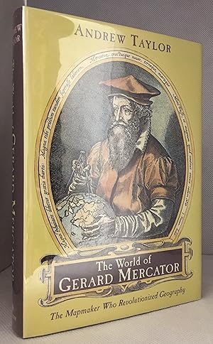
The World of Gerard Mercator; The Mapmaker Who Revolutionized Geography
Editore: Walker & Company, New York
ISBN 10: 0802713777 ISBN 13: 9780802713773
Da: Burton Lysecki Books, ABAC/ILAB, Winnipeg, MB, Canada
Membro dell'associazione: ABAC ILAB
Valutazione del venditore 5 su 5 stelle
EUR 23,44
Spedizione EUR 21,67
Spedito da Canada a U.S.A.Quantit�: 1 disponibili
Aggiungi al carrello[0-8027-1377-7] 2004. (Hardcover) Near fine in fine dust jacket. 291pp. Illustrations, maps, notes, bibliography, index. "The story of discovery and mapmaking is one of pushing back shadows, and no one in the last two thousand years achieved as much as Gerard Mercator in extending the boundaries of the known world. His life spanned most of the turbulent, extraordinary sixteenth century". Biography of Gerard Mercator. Time Period 16th Century. (Travel, Cartographers, Cartography, Geography, Mapmaking, Navigation, Travel).
-
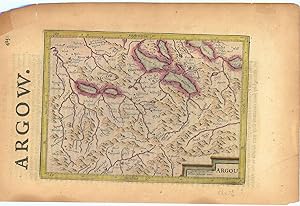
Argow (Aargau).
Editore: LondonPrinted by T.Cotes for Michael Sparkes and Samuel Cartwright ., 1635
Da: Robert Frew Ltd. ABA ILAB, London, Regno Unito
Membro dell'associazione: ABA ILAB PBFA
Valutazione del venditore 5 su 5 stelle
Mappa
EUR 29,85
Spedizione EUR 11,59
Spedito da Regno Unito a U.S.A.Quantit�: 1 disponibili
Aggiungi al carrelloOriginal engraved map of Argau / Switzerland (map dimensions 19.2 x 14 cm, overall dimensions 29.5 x 18.5 cm) with later hand-colouring. Covering the area around the Lake Lucerne, Lake Zurich and Lake Thun. With English text to verso. A bit tanned and with a few small nicks to margins, generally very good. From "Historia Mundi or Mercator's Atlas .".
-
Gerard Mercator en de geografie in de Zuidelijke Nederlanden. (16e eeuw) / Gerard Mercator et la geographie dans les Pays-Bas meridionaux. (16e si�cle).
Da: Antiquariaat A. Kok & Zn. B.V., Amsterdam, Paesi Bassi
Membro dell'associazione: ILAB NVVA
Valutazione del venditore 5 su 5 stelle
EUR 16,50
Spedizione EUR 28,27
Spedito da Paesi Bassi a U.S.A.Quantit�: 1 disponibili
Aggiungi al carrelloAntwerpen, Stad Antwerpen, Museum Plantin-Moretus & Stedelijk Prentenkabinet, 1994. 175 pp. Col. & b./w. ills. Softcover. (Publicaties van het Museum Plantin-Moretus en het Stedelijk Prentenkabinet, nr. 29).Text in Dutch & French. - Exhibition catalogue.
-
Mercator. De man die de aarde in kaart bracht. Vertaald door Jos den Bekker.
Da: Antiquariaat A. Kok & Zn. B.V., Amsterdam, Paesi Bassi
Membro dell'associazione: ILAB NVVA
Valutazione del venditore 5 su 5 stelle
EUR 16,50
Spedizione EUR 28,27
Spedito da Paesi Bassi a U.S.A.Quantit�: 1 disponibili
Aggiungi al carrelloAmst., 2003. 364,[1] pp. Col. & b./w. ills. Orig. hardcover, d./j.
-
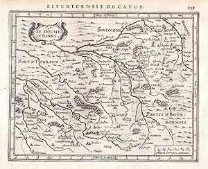
"Le Duche d'Berry" - Touraine Tours Bourges Sologne Frankreich France map Gerard Mercator
Lingua: Latino
Editore: Amsterdam, Janssonius, 1628
Da: Antiquariat Steffen V�lkel GmbH, Seubersdorf, Germania
Membro dell'associazione: ILAB VDA
Valutazione del venditore 5 su 5 stelle
Arte / Stampa / Poster
EUR 9,99
Spedizione EUR 30,00
Spedito da Germania a U.S.A.Quantit�: 1 disponibili
Aggiungi al carrelloOriginal Kupferstich-Karte von 1628 aus "Atlas Minor" von Gerard Mercator - aus der Lateinischen Ausgabe - Blatt-Ma�e: ca. 23,5 x 18 cm - teils leicht fleckig - sonst gut erhalten. -- Original engraving map of 1628 from "Atlas Minor" by Gerard Mercator's - from the Latin edition - slightly stained - otherwise in good condition. | Dies ist ein Original! - Kein Nachdruck! - Keine Kopie! -- This is an original! - No copy! - No reprint! // Wir, das Antiquariat Steffen V�lkel, kaufen und verkaufen alte B�cher, Handschriften, Zeichnungen, Autographen, Grafiken und Fotografien. Wir sind stets am Ankauf von kompletten Bibliotheken, Sammlungen und Nachl�ssen interessiert. la Gewicht in Gramm: 10.
-
![Immagine dell'editore per [Atlas Europae ] ; Gerardi Mercatoris Atlas Europae venduto da Mooney's bookstore](https://pictures.abebooks.com/isbn/9789061533184-it-300.jpg)
[Atlas Europae ] ; Gerardi Mercatoris Atlas Europae
Da: Mooney's bookstore, Den Helder, Paesi Bassi
Valutazione del venditore 4 su 5 stelle

EUR 113,22
Spedizione EUR 14,95
Spedito da Paesi Bassi a U.S.A.Quantit�: 1 disponibili
Aggiungi al carrelloCondizione: Very good.
-
Le cartographe Gerard Mercator, 1512-1594. Biblioth�que Royale Albert Ier, Bruxelles; Muse e Platin-Moretus, Anvers; Saint-Nicolas (WAES) Muse e Mercator. [Coord. g�n�rale: Jean-Marie Duvosquel & Joost De Geest].
Da: Antiquariaat A. Kok & Zn. B.V., Amsterdam, Paesi Bassi
Membro dell'associazione: ILAB NVVA
Valutazione del venditore 5 su 5 stelle
EUR 21,45
Spedizione EUR 28,27
Spedito da Paesi Bassi a U.S.A.Quantit�: 1 disponibili
Aggiungi al carrelloBruxelles, Cre dit Communal, 1994. 157 pp. Col. & b./w. ills. Softcover. - Stamp on half-title.Contribution in French by various authors.
-
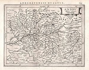
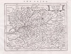
"Aniou" - Mauges Saumur Angers Anjou Nantes Frankreich France map Gerard Mercator
Lingua: Latino
Editore: Amsterdam, Janssonius, 1628
Da: Antiquariat Steffen V�lkel GmbH, Seubersdorf, Germania
Membro dell'associazione: ILAB VDA
Valutazione del venditore 5 su 5 stelle
Arte / Stampa / Poster
EUR 14,99
Spedizione EUR 30,00
Spedito da Germania a U.S.A.Quantit�: 1 disponibili
Aggiungi al carrelloOriginal Kupferstich-Karte von 1628 aus "Atlas Minor" von Gerard Mercator - aus der Lateinischen Ausgabe - Blatt-Ma�e: ca. 23,5 x 18 cm - gut erhalten. -- Original engraving map of 1628 from "Atlas Minor" by Gerard Mercator's - from the Latin edition - good condition. | Dies ist ein Original! - Kein Nachdruck! - Keine Kopie! -- This is an original! - No copy! - No reprint! // Wir, das Antiquariat Steffen V�lkel, kaufen und verkaufen alte B�cher, Handschriften, Zeichnungen, Autographen, Grafiken und Fotografien. Wir sind stets am Ankauf von kompletten Bibliotheken, Sammlungen und Nachl�ssen interessiert. la Gewicht in Gramm: 10.
-
"Aniou" - Mauges Saumur Angers Anjou Nantes Frankreich France map Gerard Mercator
Lingua: Latino
Editore: Amsterdam, Janssonius, 1651
Da: Antiquariat Steffen V�lkel GmbH, Seubersdorf, Germania
Membro dell'associazione: ILAB VDA
Valutazione del venditore 5 su 5 stelle
Arte / Stampa / Poster
EUR 14,99
Spedizione EUR 30,00
Spedito da Germania a U.S.A.Quantit�: 1 disponibili
Aggiungi al carrelloBlatt-Ma�e: ca. 17,5 x 23 cm -- Original Kupferstich-Karte von Gerard Mercator. R�ckseitig mit deutschem Text. Aus der deutschen Ausgabe des "Atlas Minor" von 1651. - gut erhalten. || Rare original copper engraved map by Gerard Mercator. With German text on verso. From the German edition of the "Atas Minor" from the year 1651. -- in very good condition. || The Flemish engraver and cartographer Jodocus Hondius (15631612), bought Mercator's plates after his death, and published this reduced version of Mercator's folio Atlas sive Cosmographis, and added some 36 of his own maps - a pocketversion - Atlas Minor - which Hondius published together with his partners Cornelius Claesz and Johannes Janssonius. It became a large success, and was translated into several languages and issued in c. 40 editions. // Wir, das Antiquariat Steffen V�lkel, kaufen und verkaufen alte B�cher, Handschriften, Zeichnungen, Autographen, Grafiken und Fotografien. Wir sind stets am Ankauf von kompletten Bibliotheken, Sammlungen und Nachl�ssen interessiert. la Gewicht in Gramm: 10.
-
Gerhard Mercator und seine Zeit. 7. Kartographiehistorisches Colloquium, Duisburg 6. - 8. Oktober 1994 [.]. Vortra ge und Berichte.
Da: Antiquariaat A. Kok & Zn. B.V., Amsterdam, Paesi Bassi
Membro dell'associazione: ILAB NVVA
Valutazione del venditore 5 su 5 stelle
EUR 24,75
Spedizione EUR 28,27
Spedito da Paesi Bassi a U.S.A.Quantit�: 1 disponibili
Aggiungi al carrelloDuisburg, Walter Braun Verlag, 1996. X,274 pp. B./w. ills. Softcover. 8vo. (Duisburger Forschungen, Band 42. / Kartographiehistorisches Colloquium, 7).Contains contributions by cartography historians from various countries covering topics from the history of cartography from the Renaissance. - Text in German.
-
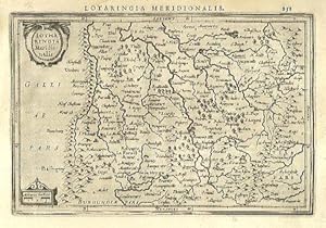
Lotharingia Meridionalis.
Editore: AmsterdamJansson., 1634
Da: Robert Frew Ltd. ABA ILAB, London, Regno Unito
Membro dell'associazione: ABA ILAB PBFA
Valutazione del venditore 5 su 5 stelle
Mappa
EUR 47,76
Spedizione EUR 11,59
Spedito da Regno Unito a U.S.A.Quantit�: 1 disponibili
Aggiungi al carrello13.4 x 19.9 cm. Uncoloured. Single page map of southern Lorraine. Latin text on verso. Light dampstain at upper left corner, otherwise in good condition.
-
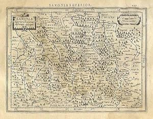
Saxoni� Superioris Lusati� Misnieque descriptio.
Editore: AmsterdamJansson., 1634
Da: Robert Frew Ltd. ABA ILAB, London, Regno Unito
Membro dell'associazione: ABA ILAB PBFA
Valutazione del venditore 5 su 5 stelle
Mappa
EUR 47,76
Spedizione EUR 11,59
Spedito da Regno Unito a U.S.A.Quantit�: 1 disponibili
Aggiungi al carrello13.6 x 18.2 cm. Uncoloured. Single page map of Saxony and the surrounding regions. Latin text on verso. Dampstain across upper and right edges of sheet, browned overall.
-
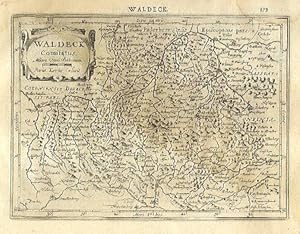
Waldeck Comitatus.
Editore: AmsterdamJansson., 1634
Da: Robert Frew Ltd. ABA ILAB, London, Regno Unito
Membro dell'associazione: ABA ILAB PBFA
Valutazione del venditore 5 su 5 stelle
Mappa
EUR 47,76
Spedizione EUR 11,59
Spedito da Regno Unito a U.S.A.Quantit�: 1 disponibili
Aggiungi al carrello14.2 x 19.3 cm. Uncoloured. Single page map of the region surrounding Waldeck, northern Hessen. Latin text on verso. Light dampstain across upper and right edges of sheet.
-
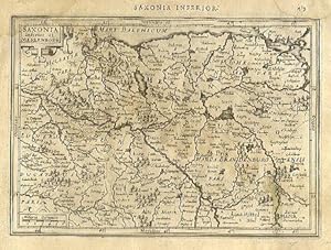
Saxonia Inferior et Meklenborg.
Editore: AmsterdamJansson., 1634
Da: Robert Frew Ltd. ABA ILAB, London, Regno Unito
Membro dell'associazione: ABA ILAB PBFA
Valutazione del venditore 5 su 5 stelle
Mappa
EUR 47,76
Spedizione EUR 11,59
Spedito da Regno Unito a U.S.A.Quantit�: 1 disponibili
Aggiungi al carrello14.2 x 20 cm. Uncoloured. Single page map showing what are now the regions of Schwerin, Rostock and Neubrandenburg. Latin text on verso. Dampstain across upper and right edges of sheet, browned overall.
-
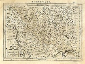
Braunswyck et Meydburg cum confinis.
Editore: AmsterdamJansson., 1634
Da: Robert Frew Ltd. ABA ILAB, London, Regno Unito
Membro dell'associazione: ABA ILAB PBFA
Valutazione del venditore 5 su 5 stelle
Mappa
EUR 47,76
Spedizione EUR 11,59
Spedito da Regno Unito a U.S.A.Quantit�: 1 disponibili
Aggiungi al carrello14.1 x 19.3 cm. Uncoloured. Single page map of the regions of Braunschweig and Magdeburg. Latin text on verso. Dampstain across upper and right edges of sheet, browned overall.
-
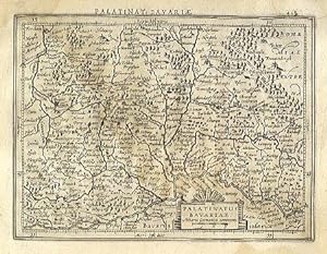
Palatinatus Bavariae.
Editore: AmsterdamJansson., 1634
Da: Robert Frew Ltd. ABA ILAB, London, Regno Unito
Membro dell'associazione: ABA ILAB PBFA
Valutazione del venditore 5 su 5 stelle
Mappa
EUR 47,76
Spedizione EUR 11,59
Spedito da Regno Unito a U.S.A.Quantit�: 1 disponibili
Aggiungi al carrello13.8 x 18.3 cm. Uncoloured. Single page map. Latin text on verso. Dampstain across upper and right edges of sheet, browned overall.
-
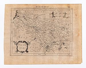
Picardia.
Editore: AmsterdamJansson., 1634
Da: Robert Frew Ltd. ABA ILAB, London, Regno Unito
Membro dell'associazione: ABA ILAB PBFA
Valutazione del venditore 5 su 5 stelle
Mappa
EUR 47,76
Spedizione EUR 11,59
Spedito da Regno Unito a U.S.A.Quantit�: 1 disponibili
Aggiungi al carrello14.5 x 18.7 cm. Uncoloured. Single page map of Picardy. Latin text on verso. Impression weaker at upper right corner. Some light soiling at margins, otherwise in good condition.
-
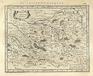
Le Duche D' Berry.
Editore: AmsterdamJansson., 1634
Da: Robert Frew Ltd. ABA ILAB, London, Regno Unito
Membro dell'associazione: ABA ILAB PBFA
Valutazione del venditore 5 su 5 stelle
Mappa
EUR 47,76
Spedizione EUR 11,59
Spedito da Regno Unito a U.S.A.Quantit�: 1 disponibili
Aggiungi al carrello14.4 x 18.1 cm. Uncoloured. Single page map. Latin text on verso. Very good condition.
-
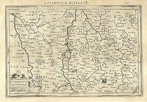
Lotharingia Septentrional.
Editore: AmsterdamJansson., 1634
Da: Robert Frew Ltd. ABA ILAB, London, Regno Unito
Membro dell'associazione: ABA ILAB PBFA
Valutazione del venditore 5 su 5 stelle
Mappa
EUR 47,76
Spedizione EUR 11,59
Spedito da Regno Unito a U.S.A.Quantit�: 1 disponibili
Aggiungi al carrello13.4 x 20.2 cm. Uncoloured. Single page map of northern Lorraine. Latin text on verso. Very good condition.
-

Bolonia et Guines com.
Editore: AmsterdamJansson., 1634
Da: Robert Frew Ltd. ABA ILAB, London, Regno Unito
Membro dell'associazione: ABA ILAB PBFA
Valutazione del venditore 5 su 5 stelle
Mappa
EUR 47,76
Spedizione EUR 11,59
Spedito da Regno Unito a U.S.A.Quantit�: 1 disponibili
Aggiungi al carrello14.6 x 18 cm. Uncoloured. Single page map of the region surrounding Boulogne. Latin text on verso. Small red mark to centre right of image. Some show through text, otherwise in good condition.
-
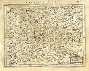
Westphali� tabula. II.
Editore: AmsterdamJansson., 1634
Da: Robert Frew Ltd. ABA ILAB, London, Regno Unito
Membro dell'associazione: ABA ILAB PBFA
Valutazione del venditore 5 su 5 stelle
Mappa
EUR 47,76
Spedizione EUR 11,59
Spedito da Regno Unito a U.S.A.Quantit�: 1 disponibili
Aggiungi al carrello13.7 x 17.7 cm. Uncoloured. Single page map of Westfalen and the Nord Rhein. Latin text on verso. Dampstaining across upper and right edges of sheet.
-
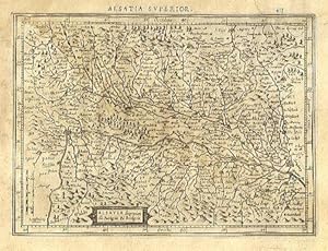
Alsatia superior cu Suntgoia & Brisgoia.
Editore: AmsterdamJansson., 1634
Da: Robert Frew Ltd. ABA ILAB, London, Regno Unito
Membro dell'associazione: ABA ILAB PBFA
Valutazione del venditore 5 su 5 stelle
Mappa
EUR 47,76
Spedizione EUR 11,59
Spedito da Regno Unito a U.S.A.Quantit�: 1 disponibili
Aggiungi al carrello14 x 19.1 cm. Uncoloured. Single page map of southern Alsace. Latin text on verso. Dampstain across upper and right edges of sheet, browned overall.
-
Palatinat. Bavariae
Editore: Amsterdam: Mercator/Hondius, 1609., 1609
Da: William Matthews/The Haunted Bookshop, Sidney, BC, Canada
Membro dell'associazione: ABAC ILAB
Valutazione del venditore 5 su 5 stelle
EUR 47,99
Spedizione EUR 15,61
Spedito da Canada a U.S.A.Quantit�: 1 disponibili
Aggiungi al carrelloA copper engraved map on laid paper, uncoloured, from the 1609 German edition of the Mercator/Hondius ATLAS MINOR. Image size is 18cm x 13.5cm, on a sheet measuring 23cm x 18cm (9 x 7 inches). Cartouche at upper right. Text on map is in Latin. Text on verso is German. Page number on verso is 442. Clean, short tear in lower margin, very good condition. A regional map of Germany, Bavaria.
-
Abruzzo et Terra di Lovoro
Editore: Amsterdam: Mercator/Hondius, 1609., 1609
Da: William Matthews/The Haunted Bookshop, Sidney, BC, Canada
Membro dell'associazione: ABAC ILAB
Valutazione del venditore 5 su 5 stelle
EUR 47,99
Spedizione EUR 15,61
Spedito da Canada a U.S.A.Quantit�: 1 disponibili
Aggiungi al carrelloA copper engraved map on laid paper, uncoloured, from the 1609 German edition of the Mercator/Hondius ATLAS MINOR. Image size is 18cm x 14.5cm, on a sheet measuring 23cm x 18cm (9 x 7 inches). Cartouche at lower right. Text on map is in Latin. Text on verso is German. Page number on verso is 536. Clean, very good condition. A regional map of Italy.
-
Romandi Ola cum D. Parmensi.
Editore: Amsterdam: Mercator/Hondius, 1609., 1609
Da: William Matthews/The Haunted Bookshop, Sidney, BC, Canada
Membro dell'associazione: ABAC ILAB
Valutazione del venditore 5 su 5 stelle
EUR 47,99
Spedizione EUR 15,61
Spedito da Canada a U.S.A.Quantit�: 1 disponibili
Aggiungi al carrelloA copper engraved map on laid paper, uncoloured, from the 1609 German edition of the Mercator/Hondius ATLAS MINOR. Image size is 18cm x 14cm, on a sheet measuring 23.5cm x 18.5cm (9 x 7 inches). Cartouche in lower right. Text on map in Latin. Text on verso is German. Page number on verso is 504. Clean, very good condition. A regional map of Italy.
-
Austria archiduc.
Editore: Amsterdam: Mercator/Hondius, 1609., 1609
Da: William Matthews/The Haunted Bookshop, Sidney, BC, Canada
Membro dell'associazione: ABAC ILAB
Valutazione del venditore 5 su 5 stelle
EUR 47,99
Spedizione EUR 15,61
Spedito da Canada a U.S.A.Quantit�: 1 disponibili
Aggiungi al carrelloA copper engraved map on laid paper, uncoloured, from the 1609 German edition of the Mercator/Hondius ATLAS MINOR. Image size is 19cm x 13cm, on a sheet measuring 23cm x 18cm (9 x 7 inches). Cartouche at lower left. Text on map is in Latin. Text on verso is German. Page number on verso is 464. Clean, very good condition. A map of �sterreich/Austria.
-
Congi Regnu.
Editore: Amsterdam: Mercator/Hondius, [c.1610]., 1610
Da: William Matthews/The Haunted Bookshop, Sidney, BC, Canada
Membro dell'associazione: ABAC ILAB
Valutazione del venditore 5 su 5 stelle
EUR 47,99
Spedizione EUR 15,61
Spedito da Canada a U.S.A.Quantit�: 1 disponibili
Aggiungi al carrelloA copper engraved map on laid paper, uncoloured, likely from a Latin edition of the Mercator/Hondius ATLAS MINOR. Image size is 17cm x 14cm, on a sheet measuring 23cm x 18cm (9 x 7 inches). Cartouche at lower left. Verso blank. Old stain to upper margin, lower right margin and bottom right margin are partly worn away, some small perforations; very good otherwise, image undamaaged. Notes in pen on upper margin: "No. 4" , etc. A map of the Congo, coast of Africa.
-
Westphaliae tabula. II.
Editore: Amsterdam: Mercator/Hondius, 1609., 1609
Da: William Matthews/The Haunted Bookshop, Sidney, BC, Canada
Membro dell'associazione: ABAC ILAB
Valutazione del venditore 5 su 5 stelle
EUR 47,99
Spedizione EUR 15,61
Spedito da Canada a U.S.A.Quantit�: 1 disponibili
Aggiungi al carrelloA copper engraved map on laid paper, uncoloured, from the 1609 German edition of the Mercator/Hondius ATLAS MINOR. Image size is 18cm x 13.5cm, on a sheet measuring 23cm x 18cm (9 x 7 inches). Cartouche at lower right. Text on map is in Latin. Text on verso is German. Page number on verso is 384. Clean, very good condition. A regional map of Germany.
-
Poictou
Editore: Amsterdam: Mercator/Hondius, 1609., 1609
Da: William Matthews/The Haunted Bookshop, Sidney, BC, Canada
Membro dell'associazione: ABAC ILAB
Valutazione del venditore 5 su 5 stelle
EUR 47,99
Spedizione EUR 15,61
Spedito da Canada a U.S.A.Quantit�: 1 disponibili
Aggiungi al carrelloA copper engraved map on laid paper, uncoloured, from the 1609 German edition of the Mercator/Hondius ATLAS MINOR. Image size is 19.5cm x 13.5cm, on a sheet measuring 23.5cm x 18.5cm (9 x 7 inches). Cartouche at upper right. Text on map is in Latin. Text on verso is German. Page number on verso is 258. Clean, very good condition. A regional map of France.


