Importo totale (1 articolo articoli):
Destinazione ordine:

greenville collins (105 risultati)
Vai alla pagina principale dei risultati di ricerca
Filtri di ricerca
Tipo di articolo
- Tutti i tipi di prodotto
- Libri (20)
- Riviste e Giornali (Nessun altro risultato corrispondente a questo perfezionamento)
- Fumetti (Nessun altro risultato corrispondente a questo perfezionamento)
- Spartiti (Nessun altro risultato corrispondente a questo perfezionamento)
- Arte, Stampe e Poster (9)
- Fotografie (Nessun altro risultato corrispondente a questo perfezionamento)
- Mappe (75)
- Manoscritti e Collezionismo cartaceo (1)
Condizioni Maggiori informazioni
- Nuovo (10)
- Come nuovo, Ottimo o Quasi ottimo (1)
- Molto buono o Buono (79)
- Discreto o Mediocre (Nessun altro risultato corrispondente a questo perfezionamento)
- Come descritto (15)
Legatura
Ulteriori caratteristiche
- Prima ed. (69)
- Copia autograf. (Nessun altro risultato corrispondente a questo perfezionamento)
- Sovracoperta (1)
- Con foto (98)
- Non Print on Demand (98)
Lingua (2)
Spedizione gratuita
Paese del venditore
Valutazione venditore
-

Secrets of the trade: For watchmakers and jewelers
Da: California Books, Miami, FL, U.S.A.
Valutazione del venditore 5 su 5 stelle

EUR 21,25
Spedizione gratuita
Spedito in U.S.A.Quantit�: Pi� di 20 disponibili
Aggiungi al carrelloCondizione: New.
-
Secrets of the trade: For watchmakers and jewelers
Da: Ria Christie Collections, Uxbridge, Regno Unito
Valutazione del venditore 5 su 5 stelle
EUR 20,64
Spedizione EUR 13,77
Spedito da Regno Unito a U.S.A.Quantit�: Pi� di 20 disponibili
Aggiungi al carrelloCondizione: New. In.
-

FACSIMILE OF CHART OF EDINBURGH FORTH, 1693
Lingua: Inglese
Editore: Holderness Publications, Burton Pidsea, East Yorkshire, 1980
Da: K Books Ltd ABA ILAB, York, YORKS, Regno Unito
Membro dell'associazione: ABA ILAB PBFA
Valutazione del venditore 5 su 5 stelle
EUR 4,73
Spedizione EUR 22,41
Spedito da Regno Unito a U.S.A.Quantit�: 1 disponibili
Aggiungi al carrelloNo Binding. Condizione: Very Good. Greenville Collins (illustratore). Facsimile. Facsimile of the beautifully engraved chart by Collins, with a dedication to the Rt Hon James, Earl of Perth, Lord Chancellor of the Kingdon of Scotland etc from Capt Greenvile Collins, Hydrographer to the King. Printed on thin card. This will be posted rolled, in a tube.
-
EUR 13,90
Spedizione EUR 70,00
Spedito da Germania a U.S.A.Quantit�: 5 disponibili
Aggiungi al carrelloTaschenbuch. Condizione: Neu. Secrets of the trade | For watchmakers and jewelers | Greenville Collins & Clifton | Taschenbuch | 92 S. | Englisch | 2017 | hansebooks | EAN 9783337135393 | Verantwortliche Person f�r die EU: Hansebooks GmbH, Trakehner Weg 52, 22844 Norderstedt, gb[at]hansebooks[dot]com | Anbieter: preigu.
-
Secrets of the trade
Da: PBShop.store US, Wood Dale, IL, U.S.A.
Valutazione del venditore 5 su 5 stelle
EUR 24,20
Spedizione gratuita
Spedito in U.S.A.Quantit�: Pi� di 20 disponibili
Aggiungi al carrelloPAP. Condizione: New. New Book. Shipped from UK. THIS BOOK IS PRINTED ON DEMAND. Established seller since 2000.
-
Secrets of the trade
Da: PBShop.store UK, Fairford, GLOS, Regno Unito
Valutazione del venditore 4 su 5 stelle

EUR 22,19
Spedizione EUR 3,78
Spedito da Regno Unito a U.S.A.Quantit�: Pi� di 20 disponibili
Aggiungi al carrelloPAP. Condizione: New. New Book. Delivered from our UK warehouse in 4 to 14 business days. THIS BOOK IS PRINTED ON DEMAND. Established seller since 2000.
-
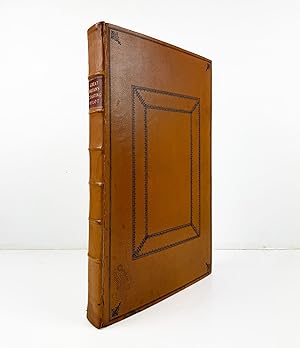
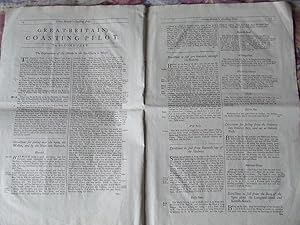
Great Britain's coasting pilot. In two parts. Being a new and exact survey of the sea-coast of England and Scotland from the river of Thames to the westward and northward with the islands of Scilly and from thence to Carlyle. Likewise the islands of Orkney and Shetland
Lingua: Inglese
Editore: William Mount and Thomas Page, London: Tower-Hill, 1744
Da: Madoc Books (ABA-ILAB), Llandudno, CONWY, Regno Unito
Membro dell'associazione: ABA ILAB IOBA PBFA
Valutazione del venditore 5 su 5 stelle
EUR 8.580,40
Spedizione EUR 34,47
Spedito da Regno Unito a U.S.A.Quantit�: 1 disponibili
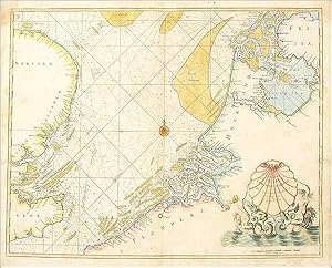
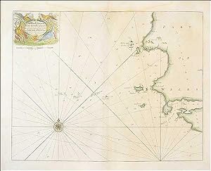
Aggiungi al carrelloHardcover. Condizione: Very Good. COLLINS Greenvile Captain (illustratore). A Landmark in the Charting of Great Britain. Folio, 18th century mottled half calf over blue-green marbled paper boards, decorative gilt spine, red morocco lettering piece, pp. [iv] + 26. Fine allegorical copperplate title (incorporating a small map of the British Isles), letter press title printed in red & black, 47 copperplate charts & profiles (5 folding, 3 single page, the remainder double page) and one chart in the text (at p18). A couple of the folding maps just torn at fold, some browning and offsetting, text spotted in places, but still a handsome copy. First published in 1693 and reissued many times throughout the eighteenth century, this formidable and costly project, [was] the first systematic survey of British coastal waters (Moreland & Bannister, Antique Maps, 3rd ed p163). (511*322 mm). (Phillips 5199. Moreland & Bannister). In 1667 the Dutch sailed up the Thames and destroyed a great part of the British Navy in the Medway and bombarded Chatham. [an] the Government was shaken. by the realisation that the Dutch new more about the coastline of England than the English themselves, and their confidence was not increased when it was found that John Seller, in producing the first volume of his marine atlas, the English Pilot, in 1671, was still using Dutch plates and often very old ones at that. As now, government was tardy in action and it was not until 1681 that Samuel Pepys, as Secretary of the Navy, instructed Captain Greenville Collins to carry out a survey of British coasts and harbours. In due course, after a seven year survey, Captain Collins issued in 1693 the Great Britain's Coasting Pilot, an outstanding work consisting of 48 charts, the first complete Pilot Book in English of all the coasts of Great Britain and the surrounding islands with special attention, of course, to the ports (Moreland & Bannister). In 1693, he finally published his results in a folio volume of two parts, Great Britain's Coasting Pilot, containing sailing directions, tide tables, coastal views and about forty-nine charts. The charts were not completely accurate, but with all their shortcomings they were an enormous advance on anything before them, and entitle Collins to rank not only with the earliest, but with the best of English hydrographers. The work covered England and Scotland, and though Collins proposed a further study to cover Ireland, the plan came to nothing. Collins recorded that he had spent �40 on instruments, and charged �80 for the 120 manuscript maps he delivered. With his claim for expenses set at �200 per annum, and his wages of �394 10s., he claimed a total of �1914 10s. for his work, which was eventually paid in arrears. The cost was more than three times the original estimate. His cousin, Freeman Collins, printed the Coasting Pilot, which Richard Mount sold. Mount's subsequent firm then went on to publish twenty-one further editions of the pilot throughout the nineteenth century.
-
Copper engraved sea chart entitled 'The Severn or Channell of Bristol' from Great Britain's Coasting Pilot"
Editore: The Sudbrook Press, 1964
Da: Victoria Bookshop, BERE ALSTON, DEVON, Regno Unito
Valutazione del venditore 4 su 5 stelle
EUR 59,18
Spedizione EUR 11,32
Spedito da Regno Unito a U.S.A.Quantit�: 1 disponibili
Aggiungi al carrelloSoft cover. Condizione: Very Good. 5th or later Edition. Great Britain's Coasting Pilot" The Reduced Facsimile Reprint of the Mount and Page 410by 330mm. Nicely framed. Book.
-

Secrets of the trade
Da: BuchWeltWeit Ludwig Meier e.K., Bergisch Gladbach, Germania
Valutazione del venditore 5 su 5 stelle
EUR 13,90
Spedizione EUR 23,00
Spedito da Germania a U.S.A.Quantit�: 2 disponibili
Aggiungi al carrelloTaschenbuch. Condizione: Neu. This item is printed on demand - it takes 3-4 days longer - Neuware -Secrets of the trade - For watchmakers and jewelers is an unchanged, high-quality reprint of the original edition of 1892.Hans Elektronisches Buch is editor of the literature on different topic areas such as research and science, travel and expeditions, cooking and nutrition, medicine, and other genres. As a publisher we focus on the preservation of historical literature. Many works of historical writers and scientists are available today as antiques only. Hans Elektronisches Buch newly publishes these books and contributes to the preservation of literature which has become rare and historical knowledge for the future. 92 pp. Englisch.
-
![Immagine del venditore per [Part of Northumberland] venduto da Antiqua Print Gallery](https://pictures.abebooks.com/inventory/md/md31458324942.jpg)
[Part of Northumberland]
Data di pubblicazione: 1693
Da: Antiqua Print Gallery, London, Regno Unito
Valutazione del venditore 4 su 5 stelle
Mappa Prima edizione
EUR 47,34
Spedizione EUR 11,49
Spedito da Regno Unito a U.S.A.Quantit�: 1 disponibili
Aggiungi al carrelloCondizione: Good. Coquet Island, Amble & Warksworth. Northumberland coast chart. COLLINS 1693 map. Decorative antique eighteenth century copperplate nautical sea chart, printed on thick paper; Captain Greenvile (or Greenville) Collins. Collins was an officer of the Royal Navy and prominent hydrographer, who was commissioned by King Charles II in 1676 and appointed by Samuel Pepys (then Secretary to the Admiralty), to chart the coasts of Great Britain. The resulting atlas - Great Britain's Coasting Pilot - was the first original sea atlas to be produced by an Englishman. Prior to publication of these maps, nautical charts were often defective, and there was no centralised system for collecting and disseminating the better maps made by experienced seamen. In 1681, Collins gained the king's preferment to survey the country's coasts. The Admiralty supplied Collins with the 8-gun yacht HMSMerlin for the first two years and later the yacht HMSMonmouth until 1686. His work was carried out under the supervision of Trinity House, who also supported the project financially. Samuel Pepys insisted that Collins be made a younger brother of Trinity House. Collins spent seven years on the survey, the first edition of which was published in 1693, as "Great Britain's Coasting Pilot". The charts, while not completely accurate, were an enormous advance on anything before them, entitling Collins to rank as not only one of the earliest, but also among the best of English hydrographers. Twenty-one further editions were published during the eighteenth century. (1693 (First edition)). 18.0 x 24.0cm, 7 x 9.5 inches. Condition: Good. Verso text quite apparent. There is text printed on the reverse side. The map shows part of the Northumberland Coast adjacent to Cocket (Coquet) island, including Hamble (Amble) and Warpsworth (Warksworth).
-

GREAT-BRITAIN'S COASTING PILOT. In Two Parts. Being a New and Exact Survey of the Sea-Coast of England and Scotland From the River of Thames to the Westward and Northward, With the Islands of Scilly, And from thence to Carlisle. Likewise the Islands of Orkney and Shetland. Describing All the Harbours, Rivers, Bays, Roads, Rocks, Sands, Buoys, Beacons, SeaMarks . With Directions for Coming into the Channel between England and France.
Editore: The Sudbrook Press Prestwood Buckinghamshire. N.d. c., 1964
Da: Francis Edwards ABA ILAB, Hay on Wye, Regno Unito
Membro dell'associazione: ABA ILAB PBFA
Valutazione del venditore 5 su 5 stelle
EUR 455,65
Spedizione EUR 21,83
Spedito da Regno Unito a U.S.A.Quantit�: 1 disponibili
Aggiungi al carrelloReduced Facsimile Reprint of the Mount and Page 1753 Ed. Folio. [vi] + 26pp. 47 charts including many double page and several folding. Light spotting moreseo to e.ps., ex.-libris Andrew David Lieutenant Commander Royal Navy, original simulated leather boards, crudely repaired d/w. chipped with loss and splits to folds. The first collected edition was published in 1693, the first complete pilot book on English the British coasts. US$516.
-
Great Britain's Coasting-Pilot: .
Editore: London: printed for Mount and Page, 1753
Da: Bruce Marshall Rare Books, Cheltenham, Regno Unito
Membro dell'associazione: ABA ILAB
Valutazione del venditore 5 su 5 stelle
EUR 8.876,27
Spedizione EUR 4,71
Spedito da Regno Unito a U.S.A.Quantit�: 1 disponibili
Aggiungi al carrelloHardcover. Condizione: Near Fine. Being a new and exact survey of the sea-coast of England and Scotland from the River of Thames to the Westward and Northward with the islands of Scilly and from thence to Carlyle. Likewise the islands of Orkney and Shetland. Describing all the harbours, rivers, bays, roads, rocks, sands, buoys, beacons, sea-marks, depths of water, latitude, bearings and distances from place to place; the setting and flowing of tides, with directions for the knowing of any place and how to harbour a ship in the same with safety. With directions for coming into the channel between England and France. London: printed for Mount and Page, 1753, [4], 26 pp. With added engraved pictorial title page; 49 copper-engraved charts & plates, all but a few double-pages, several folding out as well. (Folio) 550 x 310 mm, Full Contemporary Calf. The First and Finest Maritime Atlas of the British Isles and Ireland Greenville Collins (d. 1694; fl. 1669-1693) served in the Royal Navy with Sir John Narborough in his expedition to southern South America and the Straits of Magellan where he became highly proficient at surveying and chart-making. In the early 1680s, Collins proposed that he undertake a full-scale survey of the British coastal waters. This was a priority because the majority of existing charts were out of date and were based on earlier Dutch surveys. King Charles II was persuaded of the importance of the project and funding was duly promised, and in 1681 Collins was given command of the yacht 'Merlin'and sent to survey the British coastline. The survey took seven years (between 1681 and 1688) and resulted in about 120 manuscript charts, from which were produced forty-nine engraved charts, covering most of the British Isles and Ireland. Throughout the production of the 'Pilot' Collins struggled to get paid and eventually resorted to funding part of the project with his own money. Collins' work represents the first systematic survey of the coast of the British Isles created by an Englishman, as well as being the first marine atlas to be engraved and printed in London. As such it stands as a landmark in British chart-making and publishing. It also broke the reliance and dependence on Dutch maritime surveying. The 'Great Britain's Coasting Pilot' remained in print for one hundred years. This example is unusually clean, with wide margins and bound in contemporary calf.
-
Great-Britain's coasting pilot: Being a new and exact survey of the sea-coast of England and Scotland From the river of Thames to the Westward and Northward; with the Islands of Scilly, And from thence to Carlisle; likewise the Islands of Orkney and Shetland, describing All the Harbours, Rivers, Bays, Roads, Rocks, Sands, Buoys, Beacons, Sea-Marks, Depths of Water, Latitude, Bearings and Distances from Place to Place. The Setting and Flowing of the Tides; with Directions for the knowing of any Place, and how to Harbour a Ship in the same with Safety. With directions for coming into the Channel between England and France
Editore: Mount and Page, London, 1785
Da: Arader Books, New York, NY, U.S.A.
Valutazione del venditore 5 su 5 stelle
Hardcover. Condizione: Good. London: Mount and Page, 1785. Verner 20, penultimate edition. Folio (20" x 12 15/16", 509mm x 330mm). [Full collation available.] With 45 engraved plates: an allegorical frontispiece and 44 charts, of which 3 are folding and 38 double-page; as well as an engraved chart to p. 22. Bound in modern paneled morocco. On the spine, six raised bands. Title gilt to red morocco in the second panel. Front hinge split. Signs of damp through the binding, with some concomitant flow of mounting adhesive, visible along the lower edge of the text-block. Spine sun-faded. Folding maps folded inexpertly, resulting in creases and tears at the folds, as well as a little bowing to the front board. Peripheral tanning throughout. Damp-stain, mostly mild, to the edges throughout; moderate to the final four map-sheets. Calligraphic ink ownership of "Captain Tho.s Palmer/ His Majesty's Sloop/ Selby 1799." to the recto of the first binder's blank. Greenville Collins (Greenvill, Greenvile; ca. 1643-ca. 1695) was the first Briton to survey the coasts of Britain, having received royal assent in 1681. At vast expense over 12 years, Collins completed the work in 1693, finally replacing the charts of the Dutch against whom the British had long faught. Although not especially lauded for its accuracy, his Coasting Pilot, including some internal river-systems, was the best account of Britain's waters until the late XVIIIc; the final edition (the twenty-first) was published in 1792. Most editions had 49 or 50 charts (of a total of 58 used, some being replaced), but the collation of the work is not firmly established; long available from the firm of Mount (and later Mount & Page), which held and re-cut as necessary the copper plates, the various charts could presumably be ordered in any combination according to budget or interest (full list of plates available). The 1785 edition is recorded in three institutional libraries on OCLC: the British Library (ESTC T166525, 50 charts), Durham University (SD++ 00744; with 31 charts) and the Biblioth�que nationale de France (V-680, no count). This range, along with Verner's implicit suggestion that all editions from 1723 on are variable ("Book dealers and auction houses usually assume that there is no standard collation for an atlas. In the case of the 1693 edition. it is possible to describe a normal copy with respect to both the text and the sequence of charts"), as well as the absence of empty guards in the present example, suggests that this rare atlas is complete as purchased in the late XVIIIc. Commander Thomas Palmer (d. 1800) received his lieutenant's certificate from the Admiralty in 1789 and served as second lieutenant aboard the 32-gun frigate Niger from 1790. In 1796 he was promoted to Commander and took command of a ship for the first time in May of 1798 aboard the sloop Selby, which was built as a merchantman but purchased into the Navy as a convoy-escort. Although Capt. Palmer's signature is no guarantee that the atlas was used aboard-ship, it does suggest that he used it in the discharge of his duty. Sadly, on the morning of 3 May 1800, Capt. Palmer "shot himself in a fit of insanity." ESTC T166525; Shirley M.COLL-li. Verner, Coolie. "Captain Collins' Coasting Pilot A Carto-Bibliographical Analysis" in The Map Collectors' Circle 58 (1969), no. 20 and charts: 1, 4, 6, 9-11, 13-19, 21-40, 42, 45-50, 53, 55-57.
-
Mr. Greenvil Collins Master of His M:ts Ship the Speedwell, His Journall of the Voyage of the Said Shipp Sent, and Lost, Upon the Discovery of a North-East Passage Anno 1676. Capt. Jno Wood.
Editore: (v.p., May-August 1676), 1676
Da: Arader Galleries - AraderNYC, New York, NY, U.S.A.
Valutazione del venditore 5 su 5 stelle
Manoscritto / Collezionismo cartaceo
Hardcover. Condizione: Very Good. Manuscript folio (14 x 9 inches; 35.6 X 22.9 cm): 2 full-page maps handcolored in outline, one in-text map of the Shetland Islands, one double-page map in ink and wash of "Mount Missery," 3 ink and wash text illustrations, including one of a walrus and her calf, 18 pages of text within rules. Eighteenth-century marbled wrappers, strips of marbled paper pieced along lower margin and fore-edge of lower wrapper (edges somewhat worn and frayed), in half red morocco case. (65V8D) AN EARLY FIRSTHAND ACCOUNT OF THE QUEST FOR THE NORTHWEST PASSAGE. A manuscript journal of great interest by the renowned hydrographer, Greenville Collins, recording the details of a seventeenth-century expedition from Great Britain along the northern coast of Russia and through Nova Zembla, in search of an eastward passage to Japan and China. In 1493 to defuse trade disputes Pope Alexander VI split the discovered world in two between Spain and Portugal, leaving France, the Netherlands and England without a sea route to the trading nations of Asia. The desire to establish such a route motivated much of the European exploration of both coasts of North America. When it became apparent that there was no route through the heart of the continent, attention turned to the possibility of a passage through northern waters (but it was not until 1906 that passage from Greenland to Alaska was successfully navigated). At the command of King Charles II, the expedition set out from Deptford 6 May 1676. It consisted of two ships, the Speedwell, with John Wood as its captain and Greenville Collins as its master, and the Prosperous, commanded by Captain William Flawes. As shown by Collins's map, they sailed north toward Greenland, and then east along the ice north of Russia, through the Barents Sea. On 29 June, the Speedwell ran aground and was wrecked during a storm. The crew got safely ashore, but the ship had become separated from the Prosperous in a heavy fog. They were not rescued by the Prosperous until 8 July. Collins's log records the voyage of the Speedwell in great detail, with daily entries giving the location of the ship, wind, and weather conditions, and observations on their surroundings, including the natives, animals, and topography of the Shetland Islands. He provides a detailed map, complete with depth soundings of the passage, and directions for sailing into Brace Sound. He describes magnificent icebergs and ice formations, noting that some were the color blue, as high as the towers of Westminster Abbey, and others shaped like triumphal arches. He mentions the numerous "sea horses" (i.e., walruses) they saw and attempted to kill, and includes a sketch of a female walrus and her calf. Whales were also sighted. Once the Speedwell had run aground, the crew was able to salvage their provisions and weapons, although Captain Wood had lost his journal and notes in the wreck. The crew set up a camp called "Mount Missery," of which Collins drew a double-page topographical view, until the Prosperous came to their rescue. Greenville Collins is best known as a hydrographer in the Royal Navy and the author of Great Britain's Coasting Pilot (1693), the first survey of the country's coast undertaken by a Briton. The three maps that he drew within his journal attest to his talent and ability. The first single-page colored map shows the polar regions on a circular projection stretching from the Button, Hudson, and Baffin Bays in the west around the Arctic Circle to the presumed northern coastline of Russia to 185o east of Greenwich. The other single-page colored map is a detailed chart showing the routes of the Speedwell and Prosperous through the arctic seas north of Lapland to Nova Zembla. The in-text map shows part of the Shetland Islands and Brace Sound, with a cartouche and scale. Manuscript accounts of seventeenth-century voyages of exploration are rare, and the present journal provides a unique opportunity to obtain a firsthand account of a very early attempt at fi.
-
Cartes et plans de plusieurs parties des c�tes d'Angleterre, d'�cosse et d'Irlande.
Editore: [Paris: Jacques Bellin, 1757], 1757
Da: Arader Galleries - AraderNYC, New York, NY, U.S.A.
Valutazione del venditore 5 su 5 stelle
Original Wraps. Condizione: Very Good. Folio (53 x 36 cm.): letterpress title page containing list of contents, 19 engraved charts, all but one double-page. BINDING/CONDITION: Bound in contemporary marbled paper wrappers; spine worn, one chart with marginal chip. FRENCH EDITION OF COLLINS' LANDMARK PILOT CHARTS, FIRST PUBLISHED IN 1693. Captain Greenville Collins was an officer in the Royal Navy and 'Hydrographer to the King'. Early in his career he participated in an expedition with Sir John Narborough (ca. 1640-1688) to the coasts of South America. He took charge of the frigate Charles between 1676 and 1679 and was afterwards promoted to Commander. In 1681 Samuel Pepys, Secretary of the Admiralty, appointed Captain Collins to survey the coasts of the British Isles and supplant the outdated Dutch navigation charts that were still in use. This was the first such survey undertaken of the British coast and it proved a lengthy and expensive exercise which lasted some seven-eight years. After its completion some of London's leading engravers--including J. Harris, F. Lamb and Js. Clark, James Moxon and Herman Moll--were employed to engrave the plates, and in 1693 Great Britain's Coasting Pilot was finally published. According to Tooley, "This work forms a landmark in the charting of Great Britain, being far in advance of any previous effort in this field. It is the first complete Pilot Book in English of the whole of the coasts of Great Britain, including Orkney, Shetland and Scilly Islands, in some ways the equivalent of marine maps of Saxton's land maps." The original edition comprised 48 charts on 45 sheets. Despite its inaccuracies, Collins' work was considered a significant achievement, and during the following century his charts were re-issued in Great Britain over twenty times without revision. They were also popular in Continental Europe and were republished in France and Germany well into the 18th century. The present edition, issued by Jacques Nicolas Bellin, hydrographer to the French king, was issued in Paris in 1757, at the height of the Seven Years War and likely intended to assist the French navy in an invasion of Britain. Bellin copied 19 of the original charts detailing the major ports in the south coast, Bristol, several ports in Wales and Ireland, and approaches to Edinburgh. REFERENCES: Elizabeth Baigent, "Greenville Collins", Oxford DNB; R.V. Tooley, Maps and Map-makers, p. 54. Book.
-
Great Britain's Coasting Pilot - text
Editore: . ca, 1693
Da: McLaren Books Ltd., ABA(associate), PBFA, Largs, Regno Unito
Membro dell'associazione: ABA ILAB PBFA
Valutazione del venditore 5 su 5 stelle
EUR 88,76
Spedizione EUR 18,33
Spedito da Regno Unito a U.S.A.Quantit�: 1 disponibili
Aggiungi al carrellofolio [50x34cm]. 16 pages [11-26]. disbound. good clean condition with a few edge tears and a central fold. the second part of the text portion of Capt.Collins' famous 'Great Britain's Coasting Pilot', containing sailing directions for the east coast of England from Harwich to Berwick-on-Tweed, and a Description of the East Coast of Scotland, with the Isles of Orkney and Shetland. in addition to the text, there is an inset chart of part of the Northumberland coast [please see our storefront page for shipping information].
-
Sea Chart. Netherlands.
Lingua: Inglese
Data di pubblicazione: 1753
Da: Roz Hulse, Plymouth, DEVON, Regno Unito
Valutazione del venditore 5 su 5 stelle
Mappa
EUR 189,36
Spedizione EUR 40,22
Spedito da Regno Unito a U.S.A.Quantit�: 1 disponibili
Aggiungi al carrelloNo Binding. Condizione: Very Good. Collins, Capt. Greenville: Netherlands, Untitled chart of Holland, Flanders and Eastern England. Ca 1753. Copper engraved chart. Size approx 600mm x 480mm. Good margins, hand coloured, good impression on heavy paper. Coast line of Flanders at Calles [Calais] to Der Scheling [Terschelling]of the West Frisian Islands and then Eastern England Margate in Kent to Burnham Flats in Norfolk. Much detail is given of the Thames estuary and Rotterdam soundings. Depth soundings and rhumb lines indicated. A compass rose is set at the centre of the Chart. Title cartouche "To the Honourable Sir john Ashby Kt. Admiral of the Blew/ This is most humbly dedicated and presented by Capt G Collins". Some age soiling to edges, one small tear, without loss and repaired to centre fold area. A scarce, attractive sea chart in good, bright condition suitable for display.
-
Sea Chart of Milford Haven,
Editore: from Great Britain's Coasting Pilot, 1760
Da: Roz Hulse, Plymouth, DEVON, Regno Unito
Valutazione del venditore 5 su 5 stelle
Mappa
EUR 118,35
Spedizione EUR 40,22
Spedito da Regno Unito a U.S.A.Quantit�: 1 disponibili
Aggiungi al carrelloNo Binding. Condizione: Very Good. Collins, Greenville : Chart of Milford Haven, from Great Britain's Coasting Pilot, ca.1760. Copper engraved chart. Map size approx 560mm x 440mm. Wide margins, hand coloured, good impression on heavy paper, showing the Welsh coast at Milford Haven. Compass rose, rhumb lines, scale. Cartouche with cherub, dedicated to Sir Hugh Owen. Light water stain to top margin just touching printed area, otherwise a very good, bright and attractive chart.
-
![Immagine del venditore per Secrets of the trade. For watchmakers and jewelers . 1892 [LeatherBound] venduto da True World of Books](https://pictures.abebooks.com/inventory/md/md31533781495.jpg)
Secrets of the trade. For watchmakers and jewelers . 1892 [LeatherBound]
Data di pubblicazione: 2025
EUR 26,55
Spedizione gratuita
Spedito da India a U.S.A.Quantit�: 18 disponibili
Aggiungi al carrelloLeatherBound. Condizione: New. BOOKS ARE EXEMPT FROM IMPORT DUTIES AND TARIFFS; NO EXTRA CHARGES APPLY. LeatherBound edition. Condition: New. Reprinted from 1892 edition. Leather Binding on Spine and Corners with Golden leaf printing on spine. NO changes have been made to the original text. This is NOT a retyped or an ocr'd reprint. Illustrations, Index, if any, are included in black and white. Each page is checked manually before printing. Pages: 100 As this print on demand book is reprinted from a very old book, there could be some missing or flawed pages, but we always try to make the book as complete as possible. Fold-outs, if any, are not part of the book. If the original book was published in multiple volumes then this reprint is of only one volume, not the whole set. Sewing binding for longer life, where the book block is actually sewn (smythe sewn/section sewn) with thread before binding which results in a more durable type of binding. Pages: 100 Language: English.
-
Holy-Head.
Editore: London, Mount and Davidson, 1750
Da: Bruce Marshall Rare Books, Cheltenham, Regno Unito
Membro dell'associazione: ABA ILAB
Valutazione del venditore 5 su 5 stelle
Mappa
EUR 414,23
Spedizione EUR 4,71
Spedito da Regno Unito a U.S.A.Quantit�: 1 disponibili
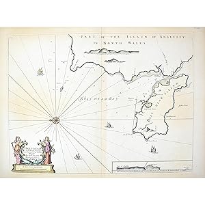
Aggiungi al carrelloNo Binding. Condizione: Very Good. Copper engraved sea chart, from Collins Great Britain s Coasting Pilot , had coloured, inset profile of Anglesey, Holy-Head and the Skerries islands, decorative title cartouche, sea embellished with ships, large compass rose, rhumb lines, slight toning, central vertical fold, London, Mount and Davidson, c.1750. In 1676 King Charles II commissioned Captain Greenville Collins to chart the coasts of Great Britain. An officer to the Royal Navy and prominent hydrographer, the atlas Collins produced was the first original sea atlas to be produced by an Englishman. Although not entirely accurate, the charts were an enormous advance on anything before them. Prior to these maps, there was no centralised system for collecting and disseminating maps made by experienced seamen. Collins spent seven years on the survey, the first edition of which was published in 1693. Great Britain s Coasting Pilot earned Collins to rank as not only one of the earliest, but also among the best of English hydrographers.
-

Holy Island Staples and Barwick. .
Editore: 1736]., 1736
Da: Maggs Bros. Ltd ABA, ILAB, PBFA, London, Regno Unito
Membro dell'associazione: ABA ILAB PBFA
Valutazione del venditore 5 su 5 stelle
Arte / Stampa / Poster
EUR 383,45
Spedizione EUR 31,02
Spedito da Regno Unito a U.S.A.Quantit�: 1 disponibili
Aggiungi al carrelloDouble-page engraved chart, 445 x 560 mm. Lightly creased. [London : Mount & Page, From Collins' Great Britain's Coasting Pilot, 1736, the first printed English sea-atlas of British coastal waters, the charts engraved from surveys made by Collins himself. Detailed chart of the�Holy Island and the Staples, off the Northumberland coast, with the mainland coast including Sunderland and Bamburgh Castle. There is an inset plan of Berwick Castle and the entrance to the Tweed.
-
![Immagine del venditore per [Untitled Chart of Carlingford Lough] venduto da Maggs Bros. Ltd ABA, ILAB, PBFA](https://pictures.abebooks.com/inventory/md/md30971888112.jpg)
[Untitled Chart of Carlingford Lough]
Editore: 1736]., 1736
Da: Maggs Bros. Ltd ABA, ILAB, PBFA, London, Regno Unito
Membro dell'associazione: ABA ILAB PBFA
Valutazione del venditore 5 su 5 stelle
Arte / Stampa / Poster
EUR 383,45
Spedizione EUR 31,02
Spedito da Regno Unito a U.S.A.Quantit�: 1 disponibili
Aggiungi al carrelloDouble-page engraved chart, 425 x 320 mm. Lightly creased. [London : Mount & Page, From Collins' Great Britain's Coasting Pilot, 1736, the first printed English sea-atlas of British coastal waters, the charts engraved from surveys made by Collins himself.
-
![Immagine del venditore per [Untitled Chart of the Menai Strait] venduto da Maggs Bros. Ltd ABA, ILAB, PBFA](https://pictures.abebooks.com/inventory/md/md30971888111.jpg)
[Untitled Chart of the Menai Strait]
Editore: 1736]., 1736
Da: Maggs Bros. Ltd ABA, ILAB, PBFA, London, Regno Unito
Membro dell'associazione: ABA ILAB PBFA
Valutazione del venditore 5 su 5 stelle
Arte / Stampa / Poster
EUR 383,45
Spedizione EUR 31,02
Spedito da Regno Unito a U.S.A.Quantit�: 1 disponibili
Aggiungi al carrelloDouble-page engraved chart, 450 x 570 mm. [London : Mount & Page, From Collins' Great Britain's Coasting Pilot, 1736, the first printed English sea-atlas of British coastal waters, the charts engraved from surveys made by Collins himself. The Menai Strait, which separates Anglesey and Caernarvonshire; the towns of Conway, Beaumaris, Bangor and Caernarvon are prominent.
-
![Immagine del venditore per [Untitled Chart of the North Sea Coast of England] venduto da Maggs Bros. Ltd ABA, ILAB, PBFA](https://pictures.abebooks.com/inventory/md/md30971882751.jpg)
[Untitled Chart of the North Sea Coast of England]
Editore: 1736]., 1736
Da: Maggs Bros. Ltd ABA, ILAB, PBFA, London, Regno Unito
Membro dell'associazione: ABA ILAB PBFA
Valutazione del venditore 5 su 5 stelle
Arte / Stampa / Poster
EUR 383,45
Spedizione EUR 31,02
Spedito da Regno Unito a U.S.A.Quantit�: 1 disponibili
Aggiungi al carrelloDouble-page engraved chart, 445 x 560 mm. Lightly creased. [London : Mount & Page, From Collins' Great Britain's Coasting Pilot, 1736, the first printed English sea-atlas of British coastal waters, the charts engraved from surveys made by Collins himself. Detailed chart of the�coast from Pevensey to the firth of Forth, with the coast of the continent from Calais to the Texel. Orientated with north at the right.
-
![Immagine del venditore per [Untitled Chart of the Coast of Wales] venduto da Maggs Bros. Ltd ABA, ILAB, PBFA](https://pictures.abebooks.com/inventory/md/md30971888110.jpg)
[Untitled Chart of the Coast of Wales]
Editore: 1736]., 1736
Da: Maggs Bros. Ltd ABA, ILAB, PBFA, London, Regno Unito
Membro dell'associazione: ABA ILAB PBFA
Valutazione del venditore 5 su 5 stelle
Arte / Stampa / Poster
EUR 447,36
Spedizione EUR 31,02
Spedito da Regno Unito a U.S.A.Quantit�: 1 disponibili
Aggiungi al carrelloDouble-page engraved chart, 450 x 565 mm. [London : Mount & Page, From Collins' Great Britain's Coasting Pilot, 1736, the first printed English sea-atlas of British coastal waters, the charts engraved from surveys made by Collins himself. The western coast of Wales from Pembroke and Milford Haven to Anglesey.
-
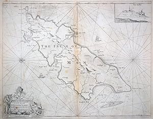
The Isle of Man.
Editore: London, 1693-1738. 445 x 560mm (17� x 22 inches)., 1738
Da: Tooley, Adams & Co., Wallingford, OXON, Regno Unito
Valutazione del venditore 5 su 5 stelle
EUR 449,73
Spedizione EUR 42,69
Spedito da Regno Unito a U.S.A.Quantit�: 1 disponibili
Aggiungi al carrelloUncoloured; slight overall age-toning, minor staining, also some light spotting mostly confirned to the margins, otherwise very good. Engraved by Herman Moll and published in Captain Greenville Collins' 'Great Britain's Coasting Pilot', as first state. A chart of the whole island, with inset of Peel Castle.
-
![Immagine del venditore per [Untitled Chart of Portland Bill and Weymouth Bay] venduto da Maggs Bros. Ltd ABA, ILAB, PBFA](https://pictures.abebooks.com/inventory/md/md30971883761.jpg)
[Untitled Chart of Portland Bill and Weymouth Bay]
Editore: 1736]., 1736
Da: Maggs Bros. Ltd ABA, ILAB, PBFA, London, Regno Unito
Membro dell'associazione: ABA ILAB PBFA
Valutazione del venditore 5 su 5 stelle
Arte / Stampa / Poster
EUR 559,21
Spedizione EUR 31,02
Spedito da Regno Unito a U.S.A.Quantit�: 1 disponibili
Aggiungi al carrelloDouble-page engraved chart, 440 x 570 mm. [London : Mount & Page, From Collins' Great Britain's Coasting Pilot, 1736, the first printed English sea-atlas of British coastal waters, the charts engraved from surveys made by Collins himself.
-
![Immagine del venditore per [Untitled Chart of Leith] venduto da Maggs Bros. Ltd ABA, ILAB, PBFA](https://pictures.abebooks.com/inventory/md/md30971883762.jpg)
[Untitled Chart of Leith]
Editore: 1736]., 1736
Da: Maggs Bros. Ltd ABA, ILAB, PBFA, London, Regno Unito
Membro dell'associazione: ABA ILAB PBFA
Valutazione del venditore 5 su 5 stelle
Arte / Stampa / Poster
EUR 621,34
Spedizione EUR 31,02
Spedito da Regno Unito a U.S.A.Quantit�: 1 disponibili
Aggiungi al carrelloDouble-page engraved chart, 445 x 570 mm. Lightly creased. [London : Mount & Page, From Collins' Great Britain's Coasting Pilot, 1736, the first printed English sea-atlas of British coastal waters, the charts engraved from surveys made by Collins himself. The chart has a fine 'Prospect of Leith from the East', with shipping in the foreground, and engraving of the town's arms.
-

This Chart of Kingsale Harbour .
Editore: 1736]., 1736
Da: Maggs Bros. Ltd ABA, ILAB, PBFA, London, Regno Unito
Membro dell'associazione: ABA ILAB PBFA
Valutazione del venditore 5 su 5 stelle
Arte / Stampa / Poster
EUR 745,61
Spedizione EUR 31,02
Spedito da Regno Unito a U.S.A.Quantit�: 1 disponibili
Aggiungi al carrelloDouble-page engraved chart, 425 x 320 mm. Lightly creased. [London : Mount & Page, From Collins' Great Britain's Coasting Pilot, 1736, the first printed English sea-atlas of British coastal waters, the charts engraved from surveys made by Collins himself. Detailed chart of the bay, harbour and coastal defences around Kinsale, with a little birds-eye view of the town.
-
![Immagine del venditore per [Untitled Chart of the western tip of Cornwall and the Scilly Isles] venduto da Maggs Bros. Ltd ABA, ILAB, PBFA](https://pictures.abebooks.com/inventory/md/md30971882755.jpg)
[Untitled Chart of the western tip of Cornwall and the Scilly Isles]
Editore: 1736]., 1736
Da: Maggs Bros. Ltd ABA, ILAB, PBFA, London, Regno Unito
Membro dell'associazione: ABA ILAB PBFA
Valutazione del venditore 5 su 5 stelle
Arte / Stampa / Poster
EUR 745,61
Spedizione EUR 31,02
Spedito da Regno Unito a U.S.A.Quantit�: 1 disponibili
Aggiungi al carrelloDouble-page engraved chart, 450 x 565 mm. [London : Mount & Page, From Collins' Great Britain's Coasting Pilot, 1736, the first printed English sea-atlas of British coastal waters, the charts engraved from surveys made by Collins himself. Cornwall is depicted from Cape Cornwall round to Lands End and the Lizard.