Importo totale (1 articolo articoli):
Destinazione ordine:

guides bleus monmarche marcel (8 risultati)
Vai alla pagina principale dei risultati di ricerca
Filtri di ricerca
Tipo di articolo
- Tutti i tipi di prodotto
- Libri (8)
- Riviste e Giornali (Nessun altro risultato corrispondente a questo perfezionamento)
- Fumetti (Nessun altro risultato corrispondente a questo perfezionamento)
- Spartiti (Nessun altro risultato corrispondente a questo perfezionamento)
- Arte, Stampe e Poster (Nessun altro risultato corrispondente a questo perfezionamento)
- Fotografie (Nessun altro risultato corrispondente a questo perfezionamento)
- Mappe (Nessun altro risultato corrispondente a questo perfezionamento)
- Manoscritti e Collezionismo cartaceo (Nessun altro risultato corrispondente a questo perfezionamento)
Condizioni Maggiori informazioni
- Nuovo (Nessun altro risultato corrispondente a questo perfezionamento)
- Come nuovo, Ottimo o Quasi ottimo (4)
- Molto buono o Buono (3)
- Discreto o Mediocre (Nessun altro risultato corrispondente a questo perfezionamento)
- Come descritto (1)
Legatura
- Tutte
- Rilegato (8)
- Brossura (Nessun altro risultato corrispondente a questo perfezionamento)
Ulteriori caratteristiche
- Prima ed. (1)
- Copia autograf. (Nessun altro risultato corrispondente a questo perfezionamento)
- Sovracoperta (3)
- Con foto (7)
- Non Print on Demand (8)
Lingua (1)
Spedizione gratuita
- Spedizione gratuita in U.S.A. (Nessun altro risultato corrispondente a questo perfezionamento)
Paese del venditore
Valutazione venditore
-

France Ouest. R�seaux de l'�tat d'Orl�ans.
Editore: Hachette, Paris, 1925
Da: Antiquariat Johann Forster, Friedenweiler, BW, Germania
Valutazione del venditore 5 su 5 stelle

EUR 15,00
Spedizione EUR 15,00
Spedito da Germania a U.S.A.Quantit�: 1 disponibili
Aggiungi al carrelloOLwd., Paris, Hachette, 1925. Kl.8�. XXXIX, 469 S. mit 32 Karten und 68 Pl�nen. OLwd., Besitzeintrag aVverso, sehr gut erhalten. (s. Foto). Les Guides Bleus. Sprache: fre Besitzeintrag aVverso, sehr gut erhalten. (s. Foto).
-
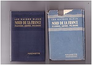
Nord de la France, Flandre, Artois, Picardie
Editore: Libraire Hachette, Paris, 1939
Da: B�cherpanorama am Johannisbad, Zwickau, Germania
Valutazione del venditore 4 su 5 stelle

EUR 24,00
Spedizione EUR 14,95
Spedito da Germania a U.S.A.Quantit�: 1 disponibili
Aggiungi al carrelloLeinen. Condizione: sehr Gut. aus Les Guides Bleus sous la direction de Marcel Monmarch� (illustratore). S. 399. SU mit kleinen Randl�suren, Buch selbst in einem tadellosen Zustand.
-

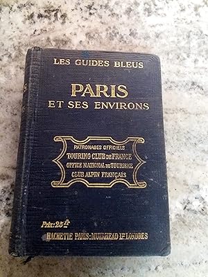
Paris et ses Environs: Les Guides Bleus
Editore: Hachette, 1924, 1924
Da: Sutton Books, Norwich, VT, U.S.A.
Membro dell'associazione: IOBA
Valutazione del venditore 5 su 5 stelle
Condizione: very good. Hbk 16mo, 466pp+ Plan de Paris appendix, text in French, illustr drawings, maps (including many fold-outs and endpaper maps) throughout, 2 ribbon markers, near fine blue cloth boards with bright gilt titles, now in custom acetate jacket, light even toning to pages otherwise appears unused and a remarkably clean tight unmarked copy.
-
PARIS ET SES ENVIRONS. Les Guides Bleus
Editore: Hachette, Paris, 1921
Da: Itziar Arranz Libros & Dribaslibros, Boadilla del Monte, M, Spagna
Membro dell'associazione: LANCE LIBRIS
Valutazione del venditore 5 su 5 stelle
EUR 14,00
Spedizione EUR 50,00
Spedito da Spagna a U.S.A.Quantit�: 1 disponibili
Aggiungi al carrelloEncuadernaci�n de tapa dura. Condizione: Aceptable. 8�. Plena tela estampada. Portada, LXXV + 511 pp. Avec une introduction par G. Len�tre. 105 plans et cartes. Cantos y puntas rozadas. Papel algo tostado. Ver fotograf�as detalle. 32-6.
-
LES ALPES FRAN�AISES; Savoie Dauphin� / Haute - Provence / Publi� Nous La Direction de Marcel Monmarch� / 85 Cartes, 1 Panorama et 22 Plans
Editore: Librairie Hachette, Paris, 1920
Da: Borg Antiquarian, Lake Forest, IL, U.S.A.
Valutazione del venditore 5 su 5 stelle
Prima edizione
Cloth. Condizione: Good. Maps, Panorama, plans (illustratore). First edition thus: FRENCH TEXT. 16mo (6 1/4" x 4 1/4"), black cloth with gilt titles & blind-stamped rules, embossing & blank rules; illustrated with 85 maps, 1 B&W panorama of Mt. Blanc & assocs., + 22 plans; silk / rayon page-marker; map endpapers; lxxx + 659 pages in French. Weight: 1 lb. 1 oz. Very useful, well illustrated, and SCARCE French imprint of LES ALPES FRAN�AIS: just after the Great War & still theirs, Hooray! Backstrip reinforced with clear tape; binding holding well though somewhat shaken; corners slightly curled; title and preliminary pages becoming loose; internally unannotated apart from recurrent stamps of "Frank J. Guscetti" of "Chicago, Illinois, October 8, 1938" in red or black--on title page & many on the backs of maps: otherwise clean; a scarce though moderately and uniformly age-toned copy (most toning to page margins) having numerous illustrations in FINE/NF condition, which include 85 partli-colored maps, 1 B&W panorama, plus 22 B&W illustrations.
-

Isra�l.
Editore: HACHETTE, 1961
Da: Le-Livre, SABLONS, Francia
Membro dell'associazione: ILAB
Valutazione del venditore 5 su 5 stelle
EUR 25,80
Spedizione EUR 42,00
Spedito da Francia a U.S.A.Quantit�: 1 disponibili
Aggiungi al carrelloCouverture rigide. Condizione: bon. RO80149408: 1961. In-16. Cartonn�. Bon �tat, Couv. convenable, Dos satisfaisant, Int�rieur acceptable. 454 pages. Quelques plans en noir et blanc, dans le texte. Nombreuses cartes d�pliantes en couleurs. . . . Classification Dewey : 956-Moyen et Proche Orient.
-

Afrique Centrale
Editore: HACHETTE, 1962
Da: Le-Livre, SABLONS, Francia
Membro dell'associazione: ILAB
Valutazione del venditore 5 su 5 stelle
EUR 45,80
Spedizione EUR 42,00
Spedito da Francia a U.S.A.Quantit�: 1 disponibili
Aggiungi al carrelloCouverture rigide. Condizione: bon. RO80149409: 1962. In-16. Cartonn�. Bon �tat, Couv. convenable, Dos satisfaisant, Int�rieur acceptable. CLXXXVIII533 pages. Quelques plans en noir et blanc, dans le texte. Nombreuses cartes d�pliantes en couleurs. Avec Jaquette. . . Classification Dewey : 967-Afrique centrale.
-
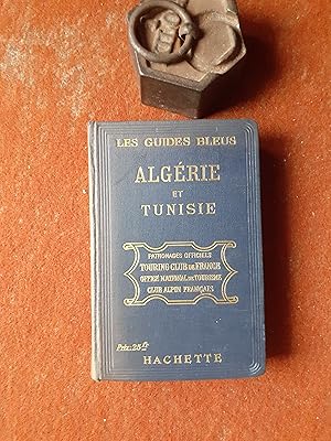
Alg�rie - Tunisie
Editore: Hachette, 1923
Da: Librairie de la Garenne, CLICHY, Francia
Valutazione del venditore 5 su 5 stelle
EUR 70,00
Spedizione EUR 37,00
Spedito da Francia a U.S.A.Quantit�: 1 disponibili
Aggiungi al carrelloCouverture rigide. Condizione: Bon. in-12 rel. toile, CXIX-468p., 61 cartes et 33 plans dont une carte d�pl. sous pochette en fin de volume, dos pass�, sinon bon �tat. Nouvelle �dition r�dig�e par MM. P. Ricard, J. Dalbanne et L. Drappier. Aper�u g�ographique par Marcel Larnaude. Aper�u historique. Aper�u religieux, artistique et litt�raire par Prosper Ricard. La principale caract�ristique de cette �dition est la place toute nouvelle et tr�s importante qu'y tient le tourisme automobile. Voir le sommaire sur photos jointes.