
Importo totale (1 articolo articoli):
Destinazione ordine:

hofmann catherine (73 risultati)
Vai alla pagina principale dei risultati di ricerca
Filtri di ricerca
Tipo di articolo
- Tutti i tipi di prodotto
- Libri (73)
- Riviste e Giornali (Nessun altro risultato corrispondente a questo perfezionamento)
- Fumetti (Nessun altro risultato corrispondente a questo perfezionamento)
- Spartiti (Nessun altro risultato corrispondente a questo perfezionamento)
- Arte, Stampe e Poster (Nessun altro risultato corrispondente a questo perfezionamento)
- Fotografie (Nessun altro risultato corrispondente a questo perfezionamento)
- Mappe (Nessun altro risultato corrispondente a questo perfezionamento)
- Manoscritti e Collezionismo cartaceo (Nessun altro risultato corrispondente a questo perfezionamento)
Condizioni Maggiori informazioni
Legatura
Ulteriori caratteristiche
- Prima ed. (14)
- Copia autograf. (Nessun altro risultato corrispondente a questo perfezionamento)
- Sovracoperta (16)
- Con foto (19)
- Non Print on Demand (72)
Lingua (4)
Spedizione gratuita
Paese del venditore
Valutazione venditore
-
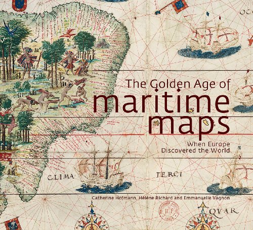
The Golden Age of Maritime Maps : When Europe Discovered the World
Da: Better World Books, Mishawaka, IN, U.S.A.
Valutazione del venditore 5 su 5 stelle

Condizione: Good. Former library copy. Pages intact with minimal writing/highlighting. The binding may be loose and creased. Dust jackets/supplements are not included. Includes library markings. Stock photo provided. Product includes identifying sticker. Better World Books: Buy Books. Do Good.
-
The Golden Age of Maritime Maps : When Europe Discovered the World
Da: Better World Books, Mishawaka, IN, U.S.A.
Valutazione del venditore 5 su 5 stelle
Condizione: Very Good. Pages intact with possible writing/highlighting. Binding strong with minor wear. Dust jackets/supplements may not be included. Stock photo provided. Product includes identifying sticker. Better World Books: Buy Books. Do Good.
-
Hardcover. Condizione: Very Good. Connecting readers with great books since 1972! Used books may not include companion materials, and may have some shelf wear or limited writing. We ship orders daily and Customer Service is our top priority!
-
The Golden Age of Maritime Maps: When Europe Discovered the World
Lingua: Inglese
Editore: Firefly Books (edition First American Edition.), 2013
ISBN 10: 1770852387 ISBN 13: 9781770852389
Da: BooksRun, Philadelphia, PA, U.S.A.
Valutazione del venditore 5 su 5 stelle
Hardcover. Condizione: Very Good. First American Edition. With dust jacket. It's a well-cared-for item that has seen limited use. The item may show minor signs of wear. All the text is legible, with all pages included. It may have slight markings and/or highlighting.
-
EUR 10,02
Spedizione EUR 10,00
Spedito da Germania a U.S.A.Quantit�: 1 disponibili
Aggiungi al carrelloCondizione: good. Befriedigend/Good: Durchschnittlich erhaltenes Buch bzw. Schutzumschlag mit Gebrauchsspuren, aber vollst�ndigen Seiten. / Describes the average WORN book or dust jacket that has all the pages present.
-
hardcover. Condizione: Good. Condizione sovraccoperta: good. A good hardcover in a good dust jacket. Sunning and closed tear to dust jacket flap. Some light edgewear to boards. No markings.
-
The Golden Age of Maritime Maps: When Europe Discovered the World
Lingua: Inglese
Editore: Firefly Books, Buffalo, New York, 2013
ISBN 10: 1770852387 ISBN 13: 9781770852389
Da: Ulysses Books, Michael L. Muilenberg, Bookseller, Trumansburg, NY, U.S.A.
Membro dell'associazione: IOBA SNEAB
Valutazione del venditore 5 su 5 stelle
Prima edizione
Hardcover. Condizione: Near Fine. Condizione sovraccoperta: Near Fine. 1st Edition. Hardcover in Near-Fine condition in a near-fine dust jacket, large squarish 4to, 256 pages. Color pictorial paper-covered boards, gray end-papers, copiously illustrated in color, bibliography, index. First printing. Very light wear, top of block slightly dusty, light wear to dust jacket spine ends. Bookseller accession no.: 25298. Extra postage may be required for international shipment of this large volume.
-
The Golden Age of Maritime Maps: When Europe Discovered the World
Da: Powell's Bookstores Chicago, ABAA, Chicago, IL, U.S.A.
Membro dell'associazione: ABAA ILAB
Valutazione del venditore 5 su 5 stelle
Hardcover. Condizione: Used-Very Good. Cloth, dj. Slight shelf wear.
-

L'âge d'or des cartes marines. Quand l'Europe d� couvrait le monde
Da: ThriftBooks-Atlanta, AUSTELL, GA, U.S.A.
Valutazione del venditore 5 su 5 stelle
Hardcover. Condizione: As New. No Jacket. Pages are clean and are not marred by notes or folds of any kind. ~ ThriftBooks: Read More, Spend Less.
-

Negotiating Migrations : The Archaeology and Politics of Mobility
Da: GreatBookPrices, Columbia, MD, U.S.A.
Valutazione del venditore 5 su 5 stelle
EUR 36,07
Spedizione EUR 2,32
Spedito in U.S.A.Quantit�: Pi� di 20 disponibili
Aggiungi al carrelloCondizione: New.
-
The golden age of maritime maps: when Europe discovered the world / under the direction of Catherine Hofmann, H�l�ne Richard, Emmanuelle Vagnon
Lingua: Inglese
Editore: Richmond Hill, Ontario; Buffalo, New York: Firefly Books, 2013
ISBN 10: 1770852387 ISBN 13: 9781770852389
Prima edizione
1st edition. Fine cloth copy in an equally fine dust-wrapper. Particularly and surprisingly well-preserved; tight, bright, clean and especially sharp-cornered. As New. Physical description; 256 pages: color illustrations, color maps; 27 x 29 cm. Notes' "First published in France under the title L'Age d'or des Cartes Marines �ditions du Seuil, 2012."--Title page verso. Catalog of the exhibition at Biblioth�que nationale de France, Paris, October 23, 2012-January 27, 2013. Includes bibliographical references (pages 248) and index. Contents; Oceanic overture / Frank Lestringant -- The fascination of portolans: historiography and collections / Catherine Hofmann -- How portolan maps were made and used through the centuries / Catherine Hofmann, H�l�ne Richard, Emmanuelle Vagnon -- Catalonian atlas -- The Mediterranean: the cradle of portolan maps / Emmanuelle Vagnon -- Navigational maps: the first widely distributed maps / Ramon J. Pujades i Bataller -- Mediterranean cartographers of the 16th and 17th centuries / Corradino Astengo -- Antique, medieval and new world cities on portolan maps / Jean-Yves Sarazin -- Insular maritime cosmography and European expansion during the Renaissance / Georges Tolias -- Nautical planisphere / Nicol� de Caverio -- The challenge of the oceans / H�l�ne Richard -- The exploration and geopolitical stakes of Iberian cartography (15th and 16th centuries) / Luisa Mart�n-Mer�s Verdejo -- From the Mediterranean to the ocean: new problems, new solutions / Joaquim Alves Gaspar -- Norman hydrographers (16th and 17th centuries) / Sarah Toulouse -- Universal cosmography / Guillaume Le Testu -- The iconography of the new world (15th-17th centuries) / Surekha Davies -- Hydrographers along the Thames (16th and 17th centuries) / Sarah Tyacke -- The Miller atlas -- The distribution of knowledge / Emmanuelle Vagnon -- Medieval cartography of the Indian Ocean: the imagined ocean / Emmanuelle Vagnon -- Nautical and humanist cartography of the Indian Ocean (16th and 17th centuries) / Zolt�n Biedermann -- Cartography of the Dutch East India Company's far east routes / Hans Kok -- Map of the Pacific Ocean / Hessel Gerritsz. Summary;"'Portolan charts,' so called from the Italian adjective portolano, meaning 'related to ports or harbours,' were born during the 12th century in the maritime community. These charts, drawn on parchment and crisscrossed with lines referring to the compass directions, indicated the succession of ports and anchorages along the shores, and were used by European sailors exploring the world up until the 18th century. Not only used as navigational instruments on boats, they were also produced for wealthy sponsors in the form of illuminated images of the world, to illustrate the economic and political interests of the major European sea powers. This book takes stock of the state of knowledge on these maps, bringing together contributions from a dozen European specialists, who trace the history and diversity of styles and places of production of these charts. This type of mapping is approached from three angles. The first part, 'The Mediterranean,' refers to the manufacture and use of the first charts, centered on the Mediterranean, and the persistence of this tradition in the Mediterranean basin until the 18th century. The second part, 'Wide Open Spaces,' shows how these regional charts have evolved from a technical and iconographical point of view at the time of the great European voyages, in order to include the oceans and new worlds. The third part, 'The Indian Ocean,' shows how these charts, in a maritime area where ancient civilizations coexisted, were dependent on other cartographic traditions (ancient, Arab, Asian) before joining the information reported by Portuguese sailors and European trading companies in the modern era." -- Publisher's website. Review: This work is for the maritime enthusiast. Included are essays by a number of European authorities who elaborate upon locations, styles, and evolution of po.
-
Negotiating Migrations : The Archaeology and Politics of Mobility
Da: GreatBookPrices, Columbia, MD, U.S.A.
Valutazione del venditore 5 su 5 stelle
EUR 37,80
Spedizione EUR 2,32
Spedito in U.S.A.Quantit�: Pi� di 20 disponibili
Aggiungi al carrelloCondizione: As New. Unread book in perfect condition.
-
THE GOLDEN AGE OF MARITIME MAPS WHEN EUROPE DISCOVERED AMERICA
Lingua: Inglese
Editore: Firefly Books, Buffalo, NY, 2013
ISBN 10: 1770852387 ISBN 13: 9781770852389
Da: Terra Firma Books, San Diego, CA, U.S.A.
Valutazione del venditore 5 su 5 stelle
Hardcover. Condizione: Near Fine. Condizione sovraccoperta: As New. Like New!2566pp; detailed index. No name or writing. CLEAN!
-
The Golden Age of Maritime Maps: When Europe Discovered the World
Lingua: Inglese
Editore: Firefly Books (U.S.) Inc., New York, 2013
ISBN 10: 1770852387 ISBN 13: 9781770852389
Da: Ryde Bookshop Ltd, Isle of Wight, Regno Unito
Valutazione del venditore 5 su 5 stelle
Prima edizione
EUR 18,03
Spedizione EUR 23,30
Spedito da Regno Unito a U.S.A.Quantit�: 1 disponibili
Aggiungi al carrelloHardcover. Condizione: Very Good. Condizione sovraccoperta: Good. First Edition First Printing. Surface of the front of the jacket is a bit wavy.
-

EUR 22,43
Spedizione EUR 10,00
Spedito da Germania a U.S.A.Quantit�: 1 disponibili
Aggiungi al carrelloCondizione: very good. Gut/Very good: Buch bzw. Schutzumschlag mit wenigen Gebrauchsspuren an Einband, Schutzumschlag oder Seiten. / Describes a book or dust jacket that does show some signs of wear on either the binding, dust jacket or pages.
-
Golden Age of Maritime Maps: When Europe Discovered the World
Da: High Street Books, New Mills, Regno Unito
Valutazione del venditore 5 su 5 stelle
EUR 19,84
Spedizione EUR 23,34
Spedito da Regno Unito a U.S.A.Quantit�: 1 disponibili
Aggiungi al carrelloHardcover. Condizione: Good. Condizione sovraccoperta: Good. Shelf wear to the dust jacket and some dust marking to the top edge. Shipped from the UK in recyclable card packaging.
-
The Golden Age of Maritime Maps. When Europe Discovered the World.
Lingua: Inglese
Editore: Firefly Books. Buffalo, N.Y. & Richmond Hill, ON., 2013
ISBN 10: 1770852387 ISBN 13: 9781770852389
Da: Richard Peterson-Bookseller, Kingston, ON, Canada
Valutazione del venditore 5 su 5 stelle
Prima edizione
EUR 22,63
Spedizione EUR 21,59
Spedito da Canada a U.S.A.Quantit�: 1 disponibili
Aggiungi al carrelloHardcover. Condizione: Fine. Condizione sovraccoperta: Fine. 1st Edition. Both the book & the dust jacket are clean, bright & unmarked. Like new. States: "First printing".
-
The golden age of maritime maps: when Europe discovered the world / under the direction of Catherine Hofmann, H�l�ne Richard, Emmanuelle Vagnon
Lingua: Inglese
Editore: Richmond Hill, Ontario; Buffalo, New York: Firefly Books, 2013
ISBN 10: 1770852387 ISBN 13: 9781770852389
Prima edizione
EUR 30,00
Spedizione EUR 13,95
Spedito da Irlanda a U.S.A.Quantit�: 1 disponibili
Aggiungi al carrello1st edition. Fine cloth copy in an equally fine dust-wrapper. Particularly and surprisingly well-preserved; tight, bright, clean and especially sharp-cornered. As New. Physical description; 256 pages: color illustrations, color maps; 27 x 29 cm. Notes' "First published in France under the title L'Age d'or des Cartes Marines �ditions du Seuil, 2012."--Title page verso. Catalog of the exhibition at Biblioth�que nationale de France, Paris, October 23, 2012-January 27, 2013. Includes bibliographical references (pages 248) and index. Contents; Oceanic overture / Frank Lestringant -- The fascination of portolans: historiography and collections / Catherine Hofmann -- How portolan maps were made and used through the centuries / Catherine Hofmann, H�l�ne Richard, Emmanuelle Vagnon -- Catalonian atlas -- The Mediterranean: the cradle of portolan maps / Emmanuelle Vagnon -- Navigational maps: the first widely distributed maps / Ramon J. Pujades i Bataller -- Mediterranean cartographers of the 16th and 17th centuries / Corradino Astengo -- Antique, medieval and new world cities on portolan maps / Jean-Yves Sarazin -- Insular maritime cosmography and European expansion during the Renaissance / Georges Tolias -- Nautical planisphere / Nicol� de Caverio -- The challenge of the oceans / H�l�ne Richard -- The exploration and geopolitical stakes of Iberian cartography (15th and 16th centuries) / Luisa Mart�n-Mer�s Verdejo -- From the Mediterranean to the ocean: new problems, new solutions / Joaquim Alves Gaspar -- Norman hydrographers (16th and 17th centuries) / Sarah Toulouse -- Universal cosmography / Guillaume Le Testu -- The iconography of the new world (15th-17th centuries) / Surekha Davies -- Hydrographers along the Thames (16th and 17th centuries) / Sarah Tyacke -- The Miller atlas -- The distribution of knowledge / Emmanuelle Vagnon -- Medieval cartography of the Indian Ocean: the imagined ocean / Emmanuelle Vagnon -- Nautical and humanist cartography of the Indian Ocean (16th and 17th centuries) / Zolt�n Biedermann -- Cartography of the Dutch East India Company's far east routes / Hans Kok -- Map of the Pacific Ocean / Hessel Gerritsz. Summary;"'Portolan charts,' so called from the Italian adjective portolano, meaning 'related to ports or harbours,' were born during the 12th century in the maritime community. These charts, drawn on parchment and crisscrossed with lines referring to the compass directions, indicated the succession of ports and anchorages along the shores, and were used by European sailors exploring the world up until the 18th century. Not only used as navigational instruments on boats, they were also produced for wealthy sponsors in the form of illuminated images of the world, to illustrate the economic and political interests of the major European sea powers. This book takes stock of the state of knowledge on these maps, bringing together contributions from a dozen European specialists, who trace the history and diversity of styles and places of production of these charts. This type of mapping is approached from three angles. The first part, 'The Mediterranean,' refers to the manufacture and use of the first charts, centered on the Mediterranean, and the persistence of this tradition in the Mediterranean basin until the 18th century. The second part, 'Wide Open Spaces,' shows how these regional charts have evolved from a technical and iconographical point of view at the time of the great European voyages, in order to include the oceans and new worlds. The third part, 'The Indian Ocean,' shows how these charts, in a maritime area where ancient civilizations coexisted, were dependent on other cartographic traditions (ancient, Arab, Asian) before joining the information reported by Portuguese sailors and European trading companies in the modern era." -- Publisher's website. Review: This work is for the maritime enthusiast. Included are essays by a number of European authorities who elaborate upon locations, styles, and evolution of portolan charts from the late Middle Ages to the Age of Discovery. The early portolans were 12th-century parchment charts that initially described coastlines, ports, and havens, with special reference to the Mediterranean. Those charts were transformed as shipping took to the oceans of the world toward the end of the Middle Ages. A glossary and list of exhibit pieces conclude a work of special interest to the historians of cartography. Color maps and other illustrations are a feature of this work. Recommended. All levels/libraries.--G. J. Martin, emeritus, Southern Connecticut State, "Choice" (05/01/2014). Subjects; Nautical charts - Europe - History - Exhibitions. Nautical charts - Mediterranean Region - History - Exhibitions. Nautical charts - Indian Ocean - History - Exhibitions. Cartography - Europe - History - Exhibitions. Discoveries in geography - Maps - History - Exhibitions. Early maps - Europe - History - Exhibitions. Ocean - Maps - Exhibitions. Maps, charts & atlases ; Maritime history; Geographical discovery & exploration. HISTORY / World. HISTORY / Historical Geography. 1.5 Kg.
-
The Golden Age of Maritime Maps: When Europe Discovered the World
Da: Zulu Books, Keswick, NA, Regno Unito
Valutazione del venditore 4 su 5 stelle

Prima edizione
EUR 15,57
Spedizione EUR 35,01
Spedito da Regno Unito a U.S.A.Quantit�: 1 disponibili
Aggiungi al carrelloHardcover. Condizione: Near Fine. 1st Edition. A near fine hardcover copy with a little shelf wear to the covers and a small nick on the lower spine end. The spine is straight, the binding is tight and the pages are clean, bright and spotting-free. A heavy book. Please see photos.
-

EUR 10,29
Spedizione EUR 40,30
Spedito da Germania a U.S.A.Quantit�: 1 disponibili
Aggiungi al carrelloCondizione: Wie neu. First American Edition. 256 S. Alle B�cher & Medienartikel von Book Broker sind stets in gutem & sehr gutem gebrauchsf�higen Zustand. Die Ausgabe des gelieferten Exemplars kann um bis zu 10 Jahre vom angegebenen Ver�ffentlichungsjahr abweichen und es kann sich um eine abweichende Auflage handeln. Unser Produktfoto entspricht dem hier angebotenen Artikel, dieser weist folgende Merkmale auf: Helle/saubere Seiten in fester Bindung. Sprache: Englisch Gewicht in Gramm: 1406 Gebundene Ausgabe, Ma�e: 27.94 cm x 2.54 cm x 25.4 cm.
-
The Golden Age of Maritime Maps: When Europe Discovered the World
Da: Carmela's Books, Leichhardt, NSW, Australia
Valutazione del venditore 2 su 5 stelle

Prima edizione
EUR 28,07
Spedizione EUR 25,49
Spedito da Australia a U.S.A.Quantit�: 1 disponibili
Aggiungi al carrelloHardcover. Condizione: Fine. Condizione sovraccoperta: Fine. First Edition. 26.0 x 28.0cms, 256pp, colour illusts.
-
The First Easter [FIRST EDITION, FIRST PRINTING] [VINTAGE 1959]
Editore: McGraw-Hill Book Company, Inc., New York, 1959
Da: Vero Beach Books, Vero Beach, FL, U.S.A.
Valutazione del venditore 5 su 5 stelle
Prima edizione
Hardcover. Condizione: Fine. Condizione sovraccoperta: Very Good. Hofmann, William (illustratore). 1st Edition. Fine condition multi-green speckled boards/black spine/gold spine lettering contained in a very good condition non price-clipped color illustrated dust jacket. The upper jacket spine edge contains moderate chipping and scattered edgewear (see photographs). The first front endpaper contains a small neatly scripted former owner name. Includes Introduction. Illustrated with black-and-white drawings. "Thousands of people felt at first hand the unforgettable force of Peter Marshall's ministry; many hundreds of thousands more have drawn inspiration and deep spiritual insight from The Prayers of Peter Marshall and from Catherine Marshall's best-selling story of his life, A Man Called Peter. For Peter Marshall's sermons proved him not only a devout man of God but also an exciting storyteller. In this book, Catherine Marshall has skillfully wrought from the many inspiring sermons of her late husband a magnificent dramatic narrative of Easter. Here in The First Easter are all the important scenes and events of Christ's Passion, from the Last Supper to the Resurrection - a drama alternately tender and terrible, but always engrossing. Through the words of Peter Marshall you will witness the tense encounter between Jesus and Judas at the Last Supper. You will walk with the disciples in the Garden of Gethsemane, where Christ is betrayed and taken prisoner. You will share the agony of Simon Peter as he thrice denies Christ before the cock crows. Peter Marshall's version of the great Easter story is exciting, reverent, and, above all, graphic. The characterizations in The First Easter are acutely drawn and poignantly real. The Savior, Simon Peter, Judas, Pilate, Caiaphas and Mary Magdalene - these and others all appear in memorable three-dimensional portraits. Dr. Marshall observes the dramatic changes wrought in the apostles by the Resurrection. He captures both the essential significance of Christ's crucifixion in His own time and, in a moving summation to the book, the meaning of Easter for today's Christians.".
-
Negotiating Migrations : The Archaeology and Politics of Mobility
Da: GreatBookPricesUK, Woodford Green, Regno Unito
Valutazione del venditore 5 su 5 stelle
EUR 36,62
Spedizione EUR 17,51
Spedito da Regno Unito a U.S.A.Quantit�: Pi� di 20 disponibili
Aggiungi al carrelloCondizione: New.
-

Hans Hofmann: Circa 1950
Lingua: Francese
Editore: The Rose art Museum, 2009
Da: Librairie-Galerie Emmanuel Hutin, Paris, Francia
Membro dell'associazione: ILAB
Valutazione del venditore 5 su 5 stelle
EUR 30,00
Spedizione EUR 11,50
Spedito da Francia a U.S.A.Quantit�: 1 disponibili
Aggiungi al carrelloCartonnage illustr� �diteur. Condizione: Neuf. Hans Hofmann (illustratore). Published in conjunction with exhibition, January 14 - April 5, 2009, at the Rose Art Museum of Brandeis University, with catalogue of 40 Abstract Expressionist paintings and drawings exhibited. Foreword and introductory essay, "Hans Hofmann, circa 1950: Painter & Writer" by Michael Rush; "The Artist and His Time" by Catherine Morris; "Hans Hofmann, I Hate to Repeat Myself" by Irving Sandler. Hardcover. >Neuf, sous film.
-
Negotiating Migrations : The Archaeology and Politics of Mobility
Da: GreatBookPricesUK, Woodford Green, Regno Unito
Valutazione del venditore 5 su 5 stelle
EUR 39,31
Spedizione EUR 17,51
Spedito da Regno Unito a U.S.A.Quantit�: Pi� di 20 disponibili
Aggiungi al carrelloCondizione: As New. Unread book in perfect condition.
-
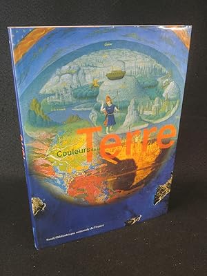
Couleurs De La Terre Des mappemondes m�di�vales aux images satellitales.
Da: ANTIQUARIAT Franke BRUDDENBOOKS, L�beck, Germania
Valutazione del venditore 5 su 5 stelle
Prima edizione
EUR 5,40
Spedizione EUR 40,10
Spedito da Germania a U.S.A.Quantit�: 1 disponibili
Aggiungi al carrelloGr.-4� Gebundene Ausgabe. Condizione: Sehr gut. 1. Auflage. 175 Seiten. Gebundenes Buch mit Original-Schutzumschlag. Das Buch ist in sehr gutem, sauberen Zustand. ISBN: 9782020354295 Wir senden umgehend mit beiliegender MwSt.Rechnung. Sprache: Franz�sisch Gewicht in Gramm: 1800.
-

The Golden Age of Maritime Maps: When Europe Discovered the World
Da: Leura Books, Bowral, NSW, Australia
Valutazione del venditore 5 su 5 stelle
EUR 31,19
Spedizione EUR 30,76
Spedito da Australia a U.S.A.Quantit�: 1 disponibili
Aggiungi al carrelloHardcover (Printed Boards). Condizione: Very Good. "Portolan charts," so called from the Italian adjective portolano, meaning "related to ports or harbours," were born during the 12th century in the maritime community. These charts, drawn on parchment and crisscrossed with lines referring to the compass directions, indicated the succession of ports and anchorages along the shores, and were used by European sailors exploring the world up until the 18th century.Not only used as navigational instruments on boats, they were also produced for wealthy sponsors in the form of illuminated images of the world, to illustrate the economic and political interests of the major European sea powers.This book takes stock of the state of knowledge on these maps, bringing together contributions from a dozen European specialists, who trace the history and diversity of styles and places of production of these charts.This type of mapping is approached from three angles. The first part, "The Mediterranean," refers to the manufacture and use of the first charts, centered on the Mediterranean, and the persistence of this tradition in the Mediterranean basin until the 18th century.The second part, "The Open Sea," shows how these regional charts have evolved from a technical and iconographical point of view at the time of the great European voyages, in order to include the oceans and new worlds.The third part, "The Indian Ocean," shows how these charts, in a maritime area where ancient civilizations coexisted, were dependent on other cartographic traditions (ancient, Arab, Asian) before joining the information reported by Portuguese sailors and European trading companies in the modern era. Oblong. 256 pages. Quantity Available: 1. Shipped Weight: 2-3 kilos. Category: maritime; Ships & The Sea; ISBN: 1770852387. ISBN/EAN: 9781770852389. Inventory No: 277419.
-
EUR 27,06
Spedizione EUR 20,99
Spedito da Repubblica Ceca a U.S.A.Quantit�: 1 disponibili
Aggiungi al carrelloHardcover. Condizione: Fair. Vergilbt / ausgeblichen; Abnutzung / Risse - deutlich.
-
Negotiating Migrations: The Archaeology and Politics of Mobility
Da: Revaluation Books, Exeter, Regno Unito
Valutazione del venditore 5 su 5 stelle
EUR 56,76
Spedizione EUR 11,67
Spedito da Regno Unito a U.S.A.Quantit�: 2 disponibili
Aggiungi al carrelloPaperback. Condizione: Brand New. 264 pages. 8.50x5.43x1.01 inches. In Stock.
-

The Golden Age of Maritime Maps: When Europe Discovered the World
Editore: Richmond Hill & Buffalo: Firefly Books, 2013
ISBN 10: 1770852387 ISBN 13: 9781770852389
Da: BookLovers of Bath, Peasedown St. John, BATH, Regno Unito
Valutazione del venditore 5 su 5 stelle
Prima edizione
EUR 30,04
Spedizione EUR 17,51
Spedito da Regno Unito a U.S.A.Quantit�: 1 disponibili
Aggiungi al carrelloHardback in Dust Wrapper. Condizione: Very Good. Condizione sovraccoperta: Very Good. First edition (first printing). Hardback. Dust wrapper over matching pictorial boards; Measures 10�" x 11�" (1.9 kg); pp 256; Index; Bibliography; Includes: List of exhibition pieces; Colour photographs; Maps (some colour); || The book is on the shelf, ready to be appropriately packed, and posted from the pastoral paradise of Peasedown St. John, Bath, by a real bookseller in a real book shop - with my personal guarantee and beady eye on the Consumer Contracts Regulations. REMEMBER! Buying my copy means the book shop Jack Russells get their supper! My Book #192995 ||.


![Immagine del venditore per The First Easter [FIRST EDITION, FIRST PRINTING] [VINTAGE 1959] venduto da Vero Beach Books](https://pictures.abebooks.com/inventory/md/md30537126968.jpg)

