
Importo totale (1 articolo articoli):
Destinazione ordine:

radefeld hauptmann (37 risultati)
Vai alla pagina principale dei risultati di ricerca
Filtri di ricerca
Tipo di articolo
- Tutti i tipi di prodotto
- Libri (1)
- Riviste e Giornali (Nessun altro risultato corrispondente a questo perfezionamento)
- Fumetti (Nessun altro risultato corrispondente a questo perfezionamento)
- Spartiti (Nessun altro risultato corrispondente a questo perfezionamento)
- Arte, Stampe e Poster (1)
- Fotografie (Nessun altro risultato corrispondente a questo perfezionamento)
- Mappe (35)
- Manoscritti e Collezionismo cartaceo (Nessun altro risultato corrispondente a questo perfezionamento)
Condizioni Maggiori informazioni
- Nuovo (Nessun altro risultato corrispondente a questo perfezionamento)
- Come nuovo, Ottimo o Quasi ottimo (Nessun altro risultato corrispondente a questo perfezionamento)
- Molto buono o Buono (2)
- Discreto o Mediocre (Nessun altro risultato corrispondente a questo perfezionamento)
- Come descritto (35)
Legatura
- Tutte
- Rilegato (Nessun altro risultato corrispondente a questo perfezionamento)
- Brossura (Nessun altro risultato corrispondente a questo perfezionamento)
Ulteriori caratteristiche
- Prima ed. (Nessun altro risultato corrispondente a questo perfezionamento)
- Copia autograf. (Nessun altro risultato corrispondente a questo perfezionamento)
- Sovracoperta (Nessun altro risultato corrispondente a questo perfezionamento)
- Con foto (36)
- Non Print on Demand (37)
Lingua (2)
Spedizione gratuita
- Spedizione gratuita in U.S.A. (Nessun altro risultato corrispondente a questo perfezionamento)
Paese del venditore
Valutazione venditore
-

Neueste Karte von Nubien, Habesch, Kordofan und Darfur. No. 48.
Editore: Bibliographisches Institut, Hildburghausen Amsterdam Paris Philadelphia, 1844
Da: Versandantiquariat H�sl, Neuried, Germania
Valutazione del venditore 5 su 5 stelle

Mappa
EUR 34,00
Spedizione EUR 9,50
Spedito da Germania a U.S.A.Quantit�: 1 disponibili
Aggiungi al carrelloCondizione: Befriedigend. Stahlstichkarte mit Grenzkolorit von Hauptmann Radefeld aus J. Meyer's Hand-Atlas. Das Blatt hat am oberen Rand deutliche Randl�suren und tr�gt einen handschriftl. Zahlenvermerk rechts oben. Sprache / Language: de 1 Seiten. ca. 36,7 x 45,8 cm.
-

England Bergzeichnung v. Hauptm Radefeld. 1852.
Editore: Bibliograph. Institut, Hildburghausen, 1852
Da: Antiquariat Reinhold Berg eK Inh. R.Berg, Regensburg, Germania
Membro dell'associazione: ILAB VDA
Valutazione del venditore 5 su 5 stelle
Mappa
EUR 40,00
Spedizione EUR 24,00
Spedito da Germania a U.S.A.Quantit�: 1 disponibili
Aggiungi al carrelloOther. Steel engraving, handcolored in outline, when published. Small and decorative map of England, showing many place names, rivers, mountains, streets and railroads. In excellent condition. 265 by 215mm (10� by 8� inches). 265 by 215mm (10� by 8� inches).
-

Frankreich 1845 - Entw. u. gez. v. Hauptmann Radefeld.
Editore: Bibliograph. Institut, Hildburghausen, 1845
Da: Antiquariat Reinhold Berg eK Inh. R.Berg, Regensburg, Germania
Membro dell'associazione: ILAB VDA
Valutazione del venditore 5 su 5 stelle
Mappa
EUR 40,00
Spedizione EUR 24,00
Spedito da Germania a U.S.A.Quantit�: 1 disponibili
Aggiungi al carrelloOther. Steel engraving, hand colored in outline. Still in good condition. 293 by 359mm (11� by 14� inches). 293 by 359mm (11� by 14� inches).
-

"Neuste Karte von Salzburg. Entw. u. gez. v. Hauptm. Radefeld". Aus: Meyer's Hand-Atlas.
Editore: Hildburghausen, Bibliographisches Institut. 1843., 1843
Da: Antiquariat MEINDL & SULZMANN OG, Wien - Vienna, Austria
Valutazione del venditore 5 su 5 stelle
EUR 30,00
Spedizione EUR 35,00
Spedito da Austria a U.S.A.Quantit�: 1 disponibili
Aggiungi al carrelloBlattgr��e ca. 34 x 42 cm. Bildausschnitt ca. 29 x 35,5 cm.
-

Schottland Bergzeichnung v. Hauptm Radefeld. 1848.
Editore: Bibliograph. Institut, Hildburghausen, 1848
Da: Antiquariat Reinhold Berg eK Inh. R.Berg, Regensburg, Germania
Membro dell'associazione: ILAB VDA
Valutazione del venditore 5 su 5 stelle
Mappa
EUR 45,00
Spedizione EUR 24,00
Spedito da Germania a U.S.A.Quantit�: 1 disponibili
Aggiungi al carrelloOther. Steel engraving, hand colored in outline, when published. Small and decorative map of Scotland, showing many place names, rivers, mountains, streets and railroads. Ornated with two inset maps: Orkney islands - Shetland islands. In excellent condition. 240 by 202mm (9� by 8 inches).
-
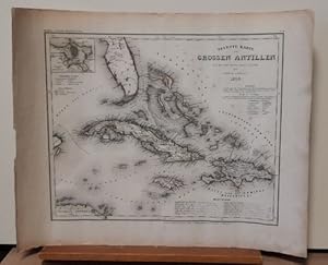
Neueste Karte der Grossen Antillen (Teilkolorierte Stahlstichkarte aus Meyers Grosser Stahlstich-Atlas)
Editore: Hildburghausen, Amsterdam, Paris und Philadelphia, Verlag des Bibliographischen Instituts, 1850
Da: ANTIQUARIAT H. EPPLER, Karlsruhe, Germania
Valutazione del venditore 5 su 5 stelle
Mappa
EUR 50,00
Spedizione EUR 19,95
Spedito da Germania a U.S.A.Quantit�: 1 disponibili
Aggiungi al carrelloCondizione: Gut. 46x36,5cm Gerollt, etwas anger�ndert, insges. gut. Sprache: Englisch, -------- Ansicht von Kuba, Jamaika und Haiti sowie einem Teil von Florida.
-

Schottland Bergzeichnung v. Hauptm Radefeld. 1849.
Editore: Bibliograph. Institut, Hildburghausen, 1849
Da: Antiquariat Reinhold Berg eK Inh. R.Berg, Regensburg, Germania
Membro dell'associazione: ILAB VDA
Valutazione del venditore 5 su 5 stelle
Mappa
EUR 45,00
Spedizione EUR 24,00
Spedito da Germania a U.S.A.Quantit�: 1 disponibili
Aggiungi al carrelloOther. Steel engraving, hand colored in outline, when published. Small and decorative map of Scotland, showing many place names, rivers, mountains, streets and railroads. Ornated with two inset maps: Orkney islands - Shetland islands. In excellent condition. 240 by 202mm (9� by 8 inches). 240 by 202mm (9� by 8 inches).
-

Das Koenigreich Italien Radefeld, Hauptmann Italian States Steel Engraving, Hand Colored published Hildburghausen 1865
Editore: Bibliograph. Institut, Hildburghausen, 1865
Da: Antiquariat Reinhold Berg eK Inh. R.Berg, Regensburg, Germania
Membro dell'associazione: ILAB VDA
Valutazione del venditore 5 su 5 stelle
Mappa
EUR 60,00
Spedizione EUR 24,00
Spedito da Germania a U.S.A.Quantit�: 1 disponibili
Aggiungi al carrelloOther. Original antique hand-colored steel engraving, published 1865. Depicting Italian States, this map is a fine example of 0s European cartography. Image: 372 by 297mm (14 by 11 inches). An attractive and historically significant 19th-century map for the discerning collector. Hauptmann von Radefeld was a German military cartographer whose work was published by the Bibliographisches Institut in Hildburghausen (later Leipzig), one of the most active German geographical publishers of the mid-19th century. His map of the Kingdom of Italy (1865) was produced during the period of Italian unification, capturing the newly consolidated Italian state.Map of the kingdom of Italy revised 1865. With many engraved names of cities, regions, etc. The political borders are shown in outline colors. A small table of explanation for the colors.A fine example from published Hildburghausen, sought after by collectors of antique maps of Italy, antique maps of Italian States, and antique hand-colored steel engravings for sale. In good condition. Colors well-preserved. In excellent condition. 372 by 297mm (14 by 11 inches). 372 by 297mm (14 by 11 inches).
-

Frankreich 1845 - Entw. u. gez. v. Hauptm. Radefeld.
Editore: Bibliograph. Institut, Hildburghausen, 1845
Da: Antiquariat Reinhold Berg eK Inh. R.Berg, Regensburg, Germania
Membro dell'associazione: ILAB VDA
Valutazione del venditore 5 su 5 stelle
Mappa
EUR 60,00
Spedizione EUR 24,00
Spedito da Germania a U.S.A.Quantit�: 1 disponibili
Aggiungi al carrelloOther. Steel engraving, hand colored in outline. In good condition. 294 by 354mm (11� by 14 inches).
-

Frankreich 1853 - Entw. u. gez. v. Hauptm. Radefeld.
Editore: Bibliograph. Institut, Hildburghausen, 1853
Da: Antiquariat Reinhold Berg eK Inh. R.Berg, Regensburg, Germania
Membro dell'associazione: ILAB VDA
Valutazione del venditore 5 su 5 stelle
Mappa
EUR 60,00
Spedizione EUR 24,00
Spedito da Germania a U.S.A.Quantit�: 1 disponibili
Aggiungi al carrelloOther. Steel engraving, hand colored in outline. In good condition. 196 by 263mm (7� by 10� inches). 196 by 263mm (7� by 10� inches).
-

Frankreich 1850 - Entw. u. gez. v. Hauptm. Radefeld.
Editore: Bibliograph. Institut, Hildburghausen, 1850
Da: Antiquariat Reinhold Berg eK Inh. R.Berg, Regensburg, Germania
Membro dell'associazione: ILAB VDA
Valutazione del venditore 5 su 5 stelle
Mappa
EUR 60,00
Spedizione EUR 24,00
Spedito da Germania a U.S.A.Quantit�: 1 disponibili
Aggiungi al carrelloOther. Steel engraving, hand colored in outline. In very good condition. 293 by 359mm (11� by 14� inches). 293 by 359mm (11� by 14� inches).
-

Neueste Karte von Nubien, Habesch, Kordofan und Dafur.
Editore: Meyer, Hildburghausen, 1850
Da: Antiquariat Reinhold Berg eK Inh. R.Berg, Regensburg, Germania
Membro dell'associazione: ILAB VDA
Valutazione del venditore 5 su 5 stelle
Mappa
EUR 60,00
Spedizione EUR 24,00
Spedito da Germania a U.S.A.Quantit�: 1 disponibili
Aggiungi al carrelloOther. Steel engraving, in original colors, as published. A detailed map of Nubia and Habesch with the Red Sea. In excellent condition. 298 by 358mm (11� by 14 inches). 298 by 358mm (11� by 14 inches).
-

Die K�nigreiche Spanien und Portugal
Editore: Meyer, Hildburghausen, 1868
Da: Antiquariat Reinhold Berg eK Inh. R.Berg, Regensburg, Germania
Membro dell'associazione: ILAB VDA
Valutazione del venditore 5 su 5 stelle
Mappa
EUR 75,00
Spedizione EUR 24,00
Spedito da Germania a U.S.A.Quantit�: 1 disponibili
Aggiungi al carrelloOther. Steel engraving, hand colored in outline when published. This detailed antique map is showing Spain and Portugal in 1868. The map is additional ornated below with two inset maps: plan of Madrid and a plan of Lisboa. A detailed map with many engraved place names, villages, streets, rivers, mountains, etc. In excellent condition. 302 by 380mm (12 by 15 inches). 302 by 380mm (12 by 15 inches).
-

Provinz Posen.
Editore: Bibliograph. Institut, Hildburghausen, 1868
Da: Antiquariat Reinhold Berg eK Inh. R.Berg, Regensburg, Germania
Membro dell'associazione: ILAB VDA
Valutazione del venditore 5 su 5 stelle
Mappa
EUR 75,00
Spedizione EUR 24,00
Spedito da Germania a U.S.A.Quantit�: 1 disponibili
Aggiungi al carrelloOther. Steel engraving, hand colored in outline when published. Detailed map of Posonia with many place names, rivers, streets and political borders. Revised 1868 by L. Ravenstein. In excellent condition. 365 by 295mm (14� by 11� inches). 365 by 295mm (14� by 11� inches).
-

General Karte Des Osmanischen Reichs.
Editore: Meyer, Hildburghausen, 1850
Da: Antiquariat Reinhold Berg eK Inh. R.Berg, Regensburg, Germania
Membro dell'associazione: ILAB VDA
Valutazione del venditore 5 su 5 stelle
Mappa
EUR 75,00
Spedizione EUR 24,00
Spedito da Germania a U.S.A.Quantit�: 1 disponibili
Aggiungi al carrelloOther. Steel engraving, hand colored in outline, when published. Decorative and interesting map showing the Osman Imperium, its political borders are shown in contemporary outline colors. In very good condition. 295 by 360mm (11� by 14� inches). 295 by 360mm (11� by 14� inches).
-

Europ�ische T�rkei 1849. Entw. u. gez. v. Hauptm. C. Radefeld.
Editore: Hildburghausen, Meyers, 1849
Da: Antiquariat Reinhold Berg eK Inh. R.Berg, Regensburg, Germania
Membro dell'associazione: ILAB VDA
Valutazione del venditore 5 su 5 stelle
Mappa
EUR 80,00
Spedizione EUR 24,00
Spedito da Germania a U.S.A.Quantit�: 1 disponibili
Aggiungi al carrelloOther. Steel engraving, hand colored in outline when published. Detailed map of the Balkan, called in this map the 'European Turkey'. Engraved and drawn by Hauptmann Radefeld, published in Meyer's Zeitungsatlas around 1849. The map shows the Turkish possessions in Southeast Europe during that period. With many detailed place names, rivers, mountains, streets, etc. In excellent condition. 300 by 385mm (11� by 15� inches).
-

Europ�ische T�rkey 1845. - Entw. u. gez. v. Hauptm. C. Radefeld.
Editore: Bibliograph. Institut, Hildburghausen, 1845
Da: Antiquariat Reinhold Berg eK Inh. R.Berg, Regensburg, Germania
Membro dell'associazione: ILAB VDA
Valutazione del venditore 5 su 5 stelle
Mappa
EUR 80,00
Spedizione EUR 24,00
Spedito da Germania a U.S.A.Quantit�: 1 disponibili
Aggiungi al carrelloOther. Steel engraving, hand colored in outline when published. Detailed map of the Balkan, called the 'European Turkey' by Hauptmann Radefeld, published in Meyer's Zeitungsatlas around 1845. The detailed map of Southeast Europe is providing a lot of information on the political divisions and borders, as well a lot of information on place names, mountains and rivers. In excellent condition. 292 by 355mm (11� by 14 inches).
-

Neueste Karte von England nach den bessten Quellen entworfen u. gezeichnet vom Hauptm. Radefeld. 1844.
Editore: Bibliograph. Institut, Hildburghausen, 1844
Da: Antiquariat Reinhold Berg eK Inh. R.Berg, Regensburg, Germania
Membro dell'associazione: ILAB VDA
Valutazione del venditore 5 su 5 stelle
Mappa
EUR 80,00
Spedizione EUR 24,00
Spedito da Germania a U.S.A.Quantit�: 1 disponibili
Aggiungi al carrelloOther. Steelengraving, handcolored in outline when published. The detailled map of England is providing a lot of information on place names and rivers. As well shiproutes from English harbours into the North Sea are engraved. 365 by 300mm (14� by 11� inches).
-

Neueste Karte von Grossbritannien und Ireland. Nach den bessten Quellen entworf. u. gezeichn. von Hauptm. Radefeld. 1844.
Editore: Bibliograph. Institut, Hildburghausen, 1844
Da: Antiquariat Reinhold Berg eK Inh. R.Berg, Regensburg, Germania
Membro dell'associazione: ILAB VDA
Valutazione del venditore 5 su 5 stelle
Mappa
EUR 80,00
Spedizione EUR 24,00
Spedito da Germania a U.S.A.Quantit�: 1 disponibili
Aggiungi al carrelloOther. Steelengraving, handcolored in outline when published. Detailled map of Great Britain and Ireland with many placenames, rivers, streets and political borders. 375 by 302mm (14� by 12 inches). 375 by 302mm (14� by 12 inches).
-

Neueste Karte von Grossbritannien und Ireland Nach den besten Quellen entworf. u. gezeichn. von Major Radefeld. 1850.
Editore: Bibliograph. Institut, Hildburghausen, 1850
Da: Antiquariat Reinhold Berg eK Inh. R.Berg, Regensburg, Germania
Membro dell'associazione: ILAB VDA
Valutazione del venditore 5 su 5 stelle
Mappa
EUR 80,00
Spedizione EUR 24,00
Spedito da Germania a U.S.A.Quantit�: 1 disponibili
Aggiungi al carrelloOther. Steelengraving, handcolored in outline when published. Detailled map of Great Britain and Ireland with many placenames, rivers, streets and political borders. In excellent condition. 380 by 300mm (15 by 11� inches). 380 by 300mm (15 by 11� inches).
-

Neueste Karte von Aegypten 1844. Entw. u. gez. v. Hauptm. Radefeld.
Editore: Meyer, Hildburghausen, 1850
Da: Antiquariat Reinhold Berg eK Inh. R.Berg, Regensburg, Germania
Membro dell'associazione: ILAB VDA
Valutazione del venditore 5 su 5 stelle
Mappa
EUR 80,00
Spedizione EUR 24,00
Spedito da Germania a U.S.A.Quantit�: 1 disponibili
Aggiungi al carrelloOther. Steel engraving, in original colors, as published. A detailed map of Egypt with the Red Sea. In excellent condition. 363 by 300mm (14� by 11� inches). 363 by 300mm (14� by 11� inches).
-

Neueste Karte von England nach den besten Quellen entworfen u. gezeichnet vom Hauptm. Radefeld. 1844
Editore: Bibliograph. Institut, Hildburghausen, 1844
Da: Antiquariat Reinhold Berg eK Inh. R.Berg, Regensburg, Germania
Membro dell'associazione: ILAB VDA
Valutazione del venditore 5 su 5 stelle
Mappa
EUR 80,00
Spedizione EUR 24,00
Spedito da Germania a U.S.A.Quantit�: 1 disponibili
Aggiungi al carrelloOther. Steelengraving, handcolored in outline when published. The detailled map of the British Isles is providing a lot of information on place names and rivers. As well shiproutes from English harbours into the North Sea are engraved. In excellent condition. 365 by 300mm (14� by 11� inches).
-

Neueste Karte von Sudan und Guinea Entworfen u. Gezeichnet von Hauptm. Radefeld.
Editore: Meyer, Hildburghausen, 1844
Da: Antiquariat Reinhold Berg eK Inh. R.Berg, Regensburg, Germania
Membro dell'associazione: ILAB VDA
Valutazione del venditore 5 su 5 stelle
Mappa
EUR 80,00
Spedizione EUR 24,00
Spedito da Germania a U.S.A.Quantit�: 1 disponibili
Aggiungi al carrelloOther. Steel engraving, hand colored in outline when published. This interesting map shows Sudan and Guinea in West Africa. The map is equipped with many place names, rivers, lakes, etc. In very good condition. 293 by 355mm (11� by 14 inches). 293 by 355mm (11� by 14 inches).
-

Neueste Karte von Grossbritannien und Ireland. Nach den besten Quellen entworf. u. gezeichn. von Hauptm. Radefeld. 1844.
Editore: Bibliograph. Institut, Hildburghausen, 1844
Da: Antiquariat Reinhold Berg eK Inh. R.Berg, Regensburg, Germania
Membro dell'associazione: ILAB VDA
Valutazione del venditore 5 su 5 stelle
Mappa
EUR 80,00
Spedizione EUR 24,00
Spedito da Germania a U.S.A.Quantit�: 1 disponibili
Aggiungi al carrelloOther. Steelengraving, handcolored in outline when published. Detailled map of Great Britain and Ireland with many placenames, rivers, streets and political borders. 375 by 302mm (14� by 12 inches). 375 by 302mm (14� by 12 inches).
-

Neueste Karte von Tunis nach den besten Quellen entworf. und gez. vom Hauptm. Radefeld.
Editore: Meyer, Hildburghausen, 1844
Da: Antiquariat Reinhold Berg eK Inh. R.Berg, Regensburg, Germania
Membro dell'associazione: ILAB VDA
Valutazione del venditore 5 su 5 stelle
Mappa
EUR 80,00
Spedizione EUR 24,00
Spedito da Germania a U.S.A.Quantit�: 1 disponibili
Aggiungi al carrelloOther. Steel engraving, in original colors, as published. A detailed map of Tunisia with many place names inland and along the coast. In excellent condition. 370 by 300mm (14� by 11� inches). 370 by 300mm (14� by 11� inches).
-

S�dliches Schweden nach Forsell Ent. u. Gez. v. Hauptm. Radefeld.
Editore: Meyers., Hildburghausen, 1845
Da: Antiquariat Reinhold Berg eK Inh. R.Berg, Regensburg, Germania
Membro dell'associazione: ILAB VDA
Valutazione del venditore 5 su 5 stelle
Mappa
EUR 95,00
Spedizione EUR 24,00
Spedito da Germania a U.S.A.Quantit�: 1 disponibili
Aggiungi al carrelloOther. A very good example of this map by Radefeld, published in Meyer's "Handatlas", contemporary colored in outline. Detailed map of Southern Sweden, providing many information on settlements, villages and cities, rivers, lakes etc. Ornated in the upper left corner with a listing of Swedish cities and the populations, near the engraved title we find mileage scales. In excellent condition. 372 by 302mm (14� by 12 inches). 372 by 302mm (14� by 12 inches).
-

Neueste Karte der K�stenl�nder des Schwarzen Meeres. - Entworfen und gezeichnet vom Hauptm. Radefeld. 1850.
Editore: Bibliograph. Institut, Hildburghausen, 1850
Da: Antiquariat Reinhold Berg eK Inh. R.Berg, Regensburg, Germania
Membro dell'associazione: ILAB VDA
Valutazione del venditore 5 su 5 stelle
Mappa
EUR 95,00
Spedizione EUR 24,00
Spedito da Germania a U.S.A.Quantit�: 1 disponibili
Aggiungi al carrelloOther. Steel engraving, hand colored in outline when published. In excellent condition. 293 by 359mm (11 by 14 inches). 293 by 359mm (11 by 14 inches).
-

Neueste Karte von Schotland Nach den bessten Quellen entworfen u. gezeichnet vom Hauptm. Radefeld. 1844.
Editore: Bibliograph. Institut, Hildburghausen, 1844
Da: Antiquariat Reinhold Berg eK Inh. R.Berg, Regensburg, Germania
Membro dell'associazione: ILAB VDA
Valutazione del venditore 5 su 5 stelle
Mappa
EUR 95,00
Spedizione EUR 24,00
Spedito da Germania a U.S.A.Quantit�: 1 disponibili
Aggiungi al carrelloOther. Steelengraving, handcolored in outline when published. The detailled map of Scotland is providing a lot of information on place names and rivers. As well shiproutes from Scotish harbours into the Atlantic Ocean and North Sea are engraved. In very good condition. A minor marginal waterstaining at the blank left corners of the paper. 370 by 300mm (14� by 11� inches). 370 by 300mm (14� by 11� inches).
-

Provinz Posen 1853. Entworf. u. gezeichn. v. Hauptm. Radefeld.
Editore: Bibliograph. Institut, Hildburghausen, 1853
Da: Antiquariat Reinhold Berg eK Inh. R.Berg, Regensburg, Germania
Membro dell'associazione: ILAB VDA
Valutazione del venditore 5 su 5 stelle
Mappa
EUR 95,00
Spedizione EUR 24,00
Spedito da Germania a U.S.A.Quantit�: 1 disponibili
Aggiungi al carrelloOther. Steel engraving, hand colored in outline when published. Detailed map of Posonia with many place names, rivers, streets and political borders. In excellent condition. 360 by 300mm (14� by 11� inches). 360 by 300mm (14� by 11� inches).
-

Neueste Karte der K�stenl�nder des Schwarzen Meeres. - Entworfen und gezeichnet vom Hauptm. Radefeld. 1845.
Editore: Bibliograph. Institut, Hildburghausen, 1845
Da: Antiquariat Reinhold Berg eK Inh. R.Berg, Regensburg, Germania
Membro dell'associazione: ILAB VDA
Valutazione del venditore 5 su 5 stelle
Mappa
EUR 95,00
Spedizione EUR 24,00
Spedito da Germania a U.S.A.Quantit�: 1 disponibili
Aggiungi al carrelloOther. Steel engraving, hand colored in outline when published. In excellent condition. 297 by 360mm (11 by 14 inches). 297 by 360mm (11 by 14 inches).
