Importo totale (1 articolo articoli):
Destinazione ordine:

ruddiman johnston (5 risultati)
Vai alla pagina principale dei risultati di ricerca
Filtri di ricerca
Tipo di articolo
- Tutti i tipi di prodotto
- Libri (5)
- Riviste e Giornali (Nessun altro risultato corrispondente a questo perfezionamento)
- Fumetti (Nessun altro risultato corrispondente a questo perfezionamento)
- Spartiti (Nessun altro risultato corrispondente a questo perfezionamento)
- Arte, Stampe e Poster (Nessun altro risultato corrispondente a questo perfezionamento)
- Fotografie (Nessun altro risultato corrispondente a questo perfezionamento)
- Mappe (Nessun altro risultato corrispondente a questo perfezionamento)
- Manoscritti e Collezionismo cartaceo (Nessun altro risultato corrispondente a questo perfezionamento)
Condizioni Maggiori informazioni
- Nuovo (Nessun altro risultato corrispondente a questo perfezionamento)
- Come nuovo, Ottimo o Quasi ottimo (Nessun altro risultato corrispondente a questo perfezionamento)
- Molto buono o Buono (1)
- Discreto o Mediocre (2)
- Come descritto (2)
Legatura
- Tutte
- Rilegato (5)
- Brossura (Nessun altro risultato corrispondente a questo perfezionamento)
Ulteriori caratteristiche
- Prima ed. (Nessun altro risultato corrispondente a questo perfezionamento)
- Copia autograf. (Nessun altro risultato corrispondente a questo perfezionamento)
- Sovracoperta (Nessun altro risultato corrispondente a questo perfezionamento)
- Con foto (4)
- Non Print on Demand (5)
Lingua (2)
Prezzo
- Qualsiasi prezzo
- Inferiore a EUR 20 (Nessun altro risultato corrispondente a questo perfezionamento)
- EUR 20 a EUR 45
- Superiore a EUR 45
Spedizione gratuita
- Spedizione gratuita in U.S.A. (Nessun altro risultato corrispondente a questo perfezionamento)
Paese del venditore
Valutazione venditore
-

The Scholars Sixpenny Atlas. Containing 35 Maps and 5 Astronomical Diagrams.
Editore: London, Johnston o.J.
Da: Antiquariat Weinek, Salzburg, Austria
Valutazione del venditore 4 su 5 stelle

EUR 24,50
Spedizione EUR 25,50
Spedito da Austria a U.S.A.Quantit�: 1 disponibili
Aggiungi al carrello32 S. OHlwd. Gbrsp., vordere Ecke m. Knickspur.
-
The Reliable Atlas: An Entirely New Atlas For Scholars And Families: Contaning Chart Of Astronomical Diagrams, 33 Modern Political Maps
Lingua: Inglese
Editore: Ruddiman Johnston, 1883
Da: Tilly's Bookshop (Eleven30 Group Ltd), Warrington, MER, Regno Unito
Valutazione del venditore 5 su 5 stelle

EUR 298,12
Spedizione EUR 23,15
Spedito da Regno Unito a U.S.A.Quantit�: 1 disponibili
Aggiungi al carrelloHardcover. Condizione: Good. brown boards, wear to corners, split down centre of spine bottom half, dulling to page edges, has physiographical Diagams, minor loss to Astronomical Diagrams page, to the margins at binding, does not interfere with diagram, 34pp ooloured maps + 14pp index, pages clean and good plus condition, scarce book.
-
The Reference Atlas of Political Geography
Editore: Ruddiman Johnston & Co Ltd
Da: The Book Box, Beccles, NORWI, Regno Unito
Valutazione del venditore 3 su 5 stelle

EUR 59,62
Spedizione EUR 34,73
Spedito da Regno Unito a U.S.A.Quantit�: 1 disponibili
Aggiungi al carrelloHardcover. Condizione: Poor. Green cloth covered boards with gilt lettering on front and spine, worn, spine cover cracked. Hinges breaking, some pages lose. An interesting look at old Empires and country boundaries that is still relevant today.
-
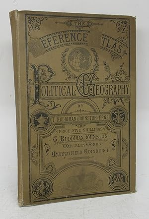
The Reference Atlas of Political Geography
Editore: Waverley Works nd. ca. 1900s, Murrayfield, Edinburgh, 1900
Da: Attic Books (ABAC, ILAB), London, ON, Canada
Membro dell'associazione: ABAC ILAB
Valutazione del venditore 5 su 5 stelle
EUR 88,73
Spedizione EUR 12,92
Spedito da Canada a U.S.A.Quantit�: 1 disponibili
Aggiungi al carrelloHardcover. Condizione: Fair. 33 p. of colour maps + 33 p. index. 31 cm. Brown cloth with black print. Corners worn, spine ends softened. Rear board and spine separated from text block and front hinge cracking internally. Blue stain on front free endpaper. A few spots and thumbing. Tears at bottom of world map. Pencil notes. Two red pencil marks on Contents page.
-
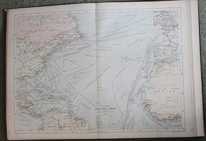
The Merchant Shipper's and Ocean Traveller's Atlas. Rare.
Editore: London: George Philip & Son The maps by T. Ruddiman Johnston, 1897
Da: Bristow & Garland, Shaftesbury, Regno Unito
Valutazione del venditore 4 su 5 stelle
EUR 357,74
Spedizione EUR 16,21
Spedito da Regno Unito a U.S.A.Quantit�: 1 disponibili
Aggiungi al carrello13 double-page & 2 single-page coloured maps. Folio (18 3/4 x 13 1/2 inches), with 9-page index at end. Original cloth. The title, preface and table of contents leaves very foxed, the maps unaffected. Binding worn and broken, the maps, apart from 1 short marginal tear, are excellent. Rare. The maps are: 1). The World - Mercator. 2). The English Channel. 3). North Sea, Baltic Sea, & Baltic Canal. 4). North Atlantic Ocean. 5). North Atlantic Western Parts, Boston and New York. 6). The North Chanel, Forth of Clyde, Irish Sea, Saint George's Channel & Manchester Ship Canal. 7). Gulf of Mexico, Caribbean Sea. 8). South Atlantic Ocean, Continuation of South America and False Bay. 9). Western Mediterranean. 10). The Eastern Mediterranean, Black Sea, Corinth Canal and Suez Canal. 11). Indian Ocean. (12). Red Sea, Arabian Sea, & Persian Gulf. 13). Bay of Bengal, China Sea, & Eastern Sea. 14). The Pacific Ocean, Nicaragua Canal, Panama Canal, & continuation of coast-line of United States. 15). Australasia.