
Importo totale (1 articolo articoli):
Destinazione ordine:

stieler adolf st�lpnagel b�r j c (4 risultati)
Vai alla pagina principale dei risultati di ricerca
Filtri di ricerca
Tipo di articolo
- Tutti i tipi di prodotto
- Libri (1)
- Riviste e Giornali (Nessun altro risultato corrispondente a questo perfezionamento)
- Fumetti (Nessun altro risultato corrispondente a questo perfezionamento)
- Spartiti (Nessun altro risultato corrispondente a questo perfezionamento)
- Arte, Stampe e Poster (Nessun altro risultato corrispondente a questo perfezionamento)
- Fotografie (Nessun altro risultato corrispondente a questo perfezionamento)
- Mappe (3)
- Manoscritti e Collezionismo cartaceo (Nessun altro risultato corrispondente a questo perfezionamento)
Condizioni Maggiori informazioni
- Nuovo (Nessun altro risultato corrispondente a questo perfezionamento)
- Come nuovo, Ottimo o Quasi ottimo (Nessun altro risultato corrispondente a questo perfezionamento)
- Molto buono o Buono (Nessun altro risultato corrispondente a questo perfezionamento)
- Discreto o Mediocre (Nessun altro risultato corrispondente a questo perfezionamento)
- Come descritto (4)
Legatura
- Tutte
- Rilegato (3)
- Brossura (Nessun altro risultato corrispondente a questo perfezionamento)
Ulteriori caratteristiche
- Prima ed. (Nessun altro risultato corrispondente a questo perfezionamento)
- Copia autograf. (Nessun altro risultato corrispondente a questo perfezionamento)
- Sovracoperta (Nessun altro risultato corrispondente a questo perfezionamento)
- Con foto (4)
- Non Print on Demand (4)
Lingua (2)
Prezzo
- Qualsiasi prezzo
- Inferiore a EUR 20 (Nessun altro risultato corrispondente a questo perfezionamento)
- EUR 20 a EUR 45 (Nessun altro risultato corrispondente a questo perfezionamento)
- Superiore a EUR 45
Spedizione gratuita
- Spedizione gratuita in U.S.A. (Nessun altro risultato corrispondente a questo perfezionamento)
Paese del venditore
Valutazione venditore
-
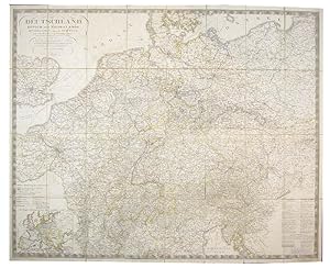
Deutschland K�nigr. der Niederlande, Kgr. Belgien und die Schweiz, nebst Theilen der angr�nzenden L�nder, nach A. Stieler's. Besonders zum Reisegebrauch eingerichtet, mit Bezeichnung der Strassen, Eilwagen-und Extrapost-Routen, unter mitwirkung des Geh. Hof- u. Finanzraths. F.M. Diez. Gemeinschaftlich gezeichnet vin F. v. St�lpnagel und J.C. B�r.
Editore: Gotha Justus Perthus, 1845
Da: Shapero Rare Books, London, Regno Unito
Membro dell'associazione: ABA ILAB PBFA
Valutazione del venditore 4 su 5 stelle

Mappa
EUR 323,29
EUR 17,13 per la spedizione da Regno Unito a U.S.A.Quantit�: 1 disponibili
Aggiungi al carrelloEngraved map, hand-coloured in outline, dissected and mounted on linen, extending west to east from London to Kracow and north to south from Copenhagen to Genoa, inset road map of Europe, lower left, key to map lower right, 'G. Biggs' mapseller's advertisements pasted to recto, publisher's label and advert pasted to endpapers, red cloth slip-case with label, worn, discolouration to map; Dimensions: 890 x 1105mm. (35 x 43.5 inches). Not traced in BLMC but c.f. BLMC Maps 26905.(86.). for 1840 edition.
-
![Immagine del venditore per Deutschland K�nigr. der Niederlande, Kgr. Belgien und die Schweiz, nebst Theilen der angr�nzenden L�nder, nach A. Stieler's. Besonders zum Reisegebrauch eingerichtet, mit Bezeichnung der Strassen, Eilwagen-und Extrapost-Routen, unter mitwirkung des Geh. Hof- u. Finanzraths. F.M. Diez. Gemeinschaftlich gezeichnet vin F. v. St�lpnagel und J.C. B�r. [with;] Eisenbahan Atlas in XV karta gratis-zugabe zu Diez' Reisekarte. venduto da Shapero Rare Books](https://pictures.abebooks.com/inventory/md/md10344399592.jpg)
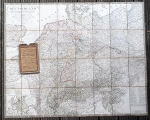
Deutschland K�nigr. der Niederlande, Kgr. Belgien und die Schweiz, nebst Theilen der angr�nzenden L�nder, nach A. Stieler's. Besonders zum Reisegebrauch eingerichtet, mit Bezeichnung der Strassen, Eilwagen-und Extrapost-Routen, unter mitwirkung des Geh. Hof- u. Finanzraths. F.M. Diez. Gemeinschaftlich gezeichnet vin F. v. St�lpnagel und J.C. B�r. [with;] Eisenbahan Atlas in XV karta gratis-zugabe zu Diez' Reisekarte.
Editore: Justus Perthus Gotha, 1850
Da: Shapero Rare Books, London, Regno Unito
Membro dell'associazione: ABA ILAB PBFA
Valutazione del venditore 4 su 5 stelle
Mappa
EUR 519,57
EUR 17,13 per la spedizione da Regno Unito a U.S.A.Quantit�: 1 disponibili
Aggiungi al carrelloEngraved map, hand-coloured in outline, dissected and mounted on linen, extending west to east from London to Kracow and north to south from Copenhagen to Genoa, inset road map of Europe lower left, key to map lower right, road map of east Germany and publisher's label pasted to verso, black cloth covers with gilt lettering, 24pp. 'Eisenbahn Atlas', incorporating 15 strip maps on 12 sheets, attached to inside cover; Dimensions: 890 x 1105mm. (35 x 43.5 inches). BLMC Maps 25.a.1.
-
Deutschland, K�nigr. der Niederlande, Kgr. Belgien und die Schweiz, nebst Theilen der angr�nzenden L�nder, nach A. Stieler's Entwurf imn Jahr 1836. Besonders zum Reisegebrauch eingerichtet, mit Bezeichnung der Strassen, Eilwagen-und Extrapost-Routen, unter Mitwirkung des Geh.-Hof- u. Finazraths und Ober-Post-Commissairs F.M. Diez. Verlag: Gotha, J.Perthes,, 1838 Unten links mit Hauptverbindungsstrassen durch Europa.
Da: Graphikantiquariat Martin Koenitz, Leipzig, SACHS, Germania
Valutazione del venditore 5 su 5 stelle

EUR 120,00
EUR 9,95 per la spedizione da Germania a U.S.A.Quantit�: 1 disponibili
Aggiungi al carrello32 Segmente auf Leinen montiert, in Stahlstich gestochene Karte, Grenzkolorit. Gr�sse: 86 x 107cm, in Orig.-Schuber mit Etikett. Schuber mit Gebrauchs- und Alterungsspuren, die Karte bis auf zwei kleine titntenflecke und wenige blasse Stockflecke in sehr gutem Zustand. Sprache: Deutsch 850 gr.
-
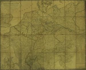
(Poststrasenkarte von) Deutschland, K�nigr. der Niederlande, Kgr. Belgien und die Schweiz, nebst Theilen der angr�nzenden L�nder, nach A. Stieler's Entwurf imn Jahr 1836. (32 Segmente auf Leinen montiert, Gr�sse: 89x 110cm.) Besonders zum Reisegebrauch eingerichtet, mit Bezeichnung der Strassen, Eilwagen-und Extrapost-Routen. Unten links mit Hauptverbindungsstrassen durch Europa.
Editore: Gotha, J.Perthes, 1840
Lingua: Tedesco
Da: Antiquariat im Schloss, Schwaigern, D, Germania
Valutazione del venditore 5 su 5 stelle
Mappa
EUR 380,00
EUR 35,00 per la spedizione da Germania a U.S.A.Quantit�: 1 disponibili
Aggiungi al carrelloSch�ne, saubere, in Stahl gestochene Karte, grenzkolorirt. Angebr�unt. R�nder minim. br�chig. Sprache: Deutsch Gewicht in Gramm: 900.