
Importo totale (1 articolo articoli):
Destinazione ordine:

woodman mutlow (5 risultati)
Vai alla pagina principale dei risultati di ricerca
Filtri di ricerca
Tipo di articolo
- Tutti i tipi di prodotto
- Libri (1)
- Riviste e Giornali (Nessun altro risultato corrispondente a questo perfezionamento)
- Fumetti (Nessun altro risultato corrispondente a questo perfezionamento)
- Spartiti (Nessun altro risultato corrispondente a questo perfezionamento)
- Arte, Stampe e Poster (1)
- Fotografie (Nessun altro risultato corrispondente a questo perfezionamento)
- Mappe (3)
- Manoscritti e Collezionismo cartaceo (Nessun altro risultato corrispondente a questo perfezionamento)
Condizioni Maggiori informazioni
- Nuovo (Nessun altro risultato corrispondente a questo perfezionamento)
- Come nuovo, Ottimo o Quasi ottimo (Nessun altro risultato corrispondente a questo perfezionamento)
- Molto buono o Buono (2)
- Discreto o Mediocre (Nessun altro risultato corrispondente a questo perfezionamento)
- Come descritto (3)
Legatura
- Tutte
- Rilegato (Nessun altro risultato corrispondente a questo perfezionamento)
- Brossura (Nessun altro risultato corrispondente a questo perfezionamento)
Ulteriori caratteristiche
- Prima ed. (Nessun altro risultato corrispondente a questo perfezionamento)
- Copia autograf. (Nessun altro risultato corrispondente a questo perfezionamento)
- Sovracoperta (Nessun altro risultato corrispondente a questo perfezionamento)
- Con foto (4)
- Non Print on Demand (5)
Lingua (1)
Prezzo
- Qualsiasi prezzo
- Inferiore a EUR 20 (Nessun altro risultato corrispondente a questo perfezionamento)
- EUR 20 a EUR 45
- Superiore a EUR 45
Spedizione gratuita
- Spedizione gratuita in U.S.A. (Nessun altro risultato corrispondente a questo perfezionamento)
Paese del venditore
Valutazione venditore
-

A Map of the Country from 14 to 18 Miles round Windsor
Data di pubblicazione: 1790
Da: Morning Mist Books and Maps, Cirencester, Regno Unito
Valutazione del venditore 5 su 5 stelle

Mappa
EUR 23,83
Spedizione EUR 52,05
Spedito da Regno Unito a U.S.A.Quantit�: 1 disponibili
Aggiungi al carrelloNo Binding. Condizione: Good. Undated but presumed circa 1780-1790. Uncoloured. General dust-marking and toning consistent with age. Two pin holes: central upper and lower margins. Slight central fold. Printing clear (magnifier recommended). Area covered: Blackwater (S.W.); High Wickham (N.W.); Watford (N.E.); Cobham (S.E.). River Thames: Kew to Henley. Sheet size: 24cm by 30cm approx. Further details available on request. (non427cb).
-
Two engraved maps
Editore: Harrison & Co, [London, 1784
Da: The Old Mill Bookshop, HACKETTSTOWN, NJ, U.S.A.
Valutazione del venditore 3 su 5 stelle

1 vols. 10 x 7 3/4 inches. 1 vols. 10 x 7 3/4 inches. The first "A General Stereographic Map, on the Plane of the Meridian" and the other showing a "Stereographic Projection on the Plane of the Horizon" and "Orthographic Projection on the pLane of the Meridian" Maps of the Hemispheres. Extracted from a volume. Some light marginal discoloration, folds, else in very good condition.
-
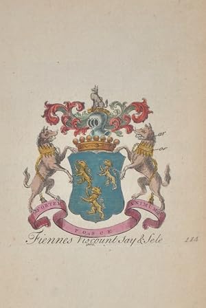
Fortem Posce Animum / Fiennes Viscount Say & Sele
Editore: Artist: Woodman & Mutlow ca :, 1780
Da: Antique Sommer& Sapunaru KG, M�nchen, Germania
Membro dell'associazione: ILAB VDA
Valutazione del venditore 3 su 5 stelle
Arte / Stampa / Poster
EUR 100,00
Spedizione EUR 45,00
Spedito da Germania a U.S.A.Quantit�: 1 disponibili
Aggiungi al carrelloTechnic: Copper print, colorit: colored, condition: Perfect condition, size (in cm): 8 x 7,5 cm, Coat of arms of an English baron.
-

The Country twenty-two miles round London. Compiled from actual surveys on a scale of half an inch to a mile. T. Woodman & H. Mutlow sculpt.
Editore: J. Wallis, London, 1783
Da: Harry E Bagley Books, Fredericton, NB, Canada
Valutazione del venditore 3 su 5 stelle
Mappa
EUR 177,04
Spedizione EUR 25,78
Spedito da Canada a U.S.A.Quantit�: 1 disponibili
Aggiungi al carrelloNo Binding. Condizione: Very Good. framed map, 570 x 570 mm, On a scale of half an inch to a mile., Engraved by Woodman and Mutlow. On folding linen in 16 sections. Map.
-
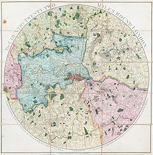
The Country Twenty-Two Miles Round London. Compiled from Actual Surveys, on a Scale of Half an Inch to a Mile.
Editore: LondonE. Wallis No. 42 Skinner Street Snow Hill. N.D. but after, 1818
Da: Robert Frew Ltd. ABA ILAB, London, Regno Unito
Membro dell'associazione: ABA ILAB PBFA
Valutazione del venditore 5 su 5 stelle
Mappa
EUR 774,45
Spedizione EUR 11,57
Spedito da Regno Unito a U.S.A.Quantit�: 1 disponibili
Aggiungi al carrelloOverall dimensions 59 x 58.5 cm, diameter 55.5 cm. Circular map of the environs of London, showing the extents from Ware down to Dorking and Tilbury across to Windsor. Full original colour in block and outline: the city shaded in dark red, the county shaded in different colours and parks and woodlands coloured in green. The five mile radius from St. Paul's marked out, after which thin concentric lines radiate out at one mile intervals up to border. A number of roads leading out of London shaded and their distances from the edges of city marked along route. The whole dissected into fifteen sections and backed onto linen. Minor creasing at some section edges. Small brown spot to upper left corner, otherwise an attractive example. The Wallis family firm moved to 42 Skinner Street in 1813. Edward Wallis entered into partnership with his father, John, in the same year. On John Wallis' demise in 1818 Edward assumed full control of the business. This an intermediate issue, Howgego notes editions with John Wallis' imprint up to 1802 and one subsequent edition with an attributed date of c. 1845. This example certainly published prior to the latter date as none of the railways are shown. Cf. Howgego, No. 176. This edition not listed by Boyle, cf 16 for the first state.

