Importo totale (1 articolo articoli):
Destinazione ordine:

atlas minor di seutter matthaeus (11 risultati)
Vai alla pagina principale dei risultati di ricerca
Filtri di ricerca
Tipo di articolo
- Tutti i tipi di prodotto
- Libri (3)
- Riviste e Giornali (Nessun altro risultato corrispondente a questo perfezionamento)
- Fumetti (Nessun altro risultato corrispondente a questo perfezionamento)
- Spartiti (Nessun altro risultato corrispondente a questo perfezionamento)
- Arte, Stampe e Poster (Nessun altro risultato corrispondente a questo perfezionamento)
- Fotografie (Nessun altro risultato corrispondente a questo perfezionamento)
- Mappe (8)
- Manoscritti e Collezionismo cartaceo (Nessun altro risultato corrispondente a questo perfezionamento)
Condizioni Maggiori informazioni
- Nuovo (Nessun altro risultato corrispondente a questo perfezionamento)
- Come nuovo, Ottimo o Quasi ottimo (Nessun altro risultato corrispondente a questo perfezionamento)
- Molto buono o Buono (8)
- Discreto o Mediocre (Nessun altro risultato corrispondente a questo perfezionamento)
- Come descritto (3)
Legatura
- Tutte
- Rilegato (Nessun altro risultato corrispondente a questo perfezionamento)
- Brossura (1)
Ulteriori caratteristiche
- Prima ed. (Nessun altro risultato corrispondente a questo perfezionamento)
- Copia autograf. (Nessun altro risultato corrispondente a questo perfezionamento)
- Sovracoperta (Nessun altro risultato corrispondente a questo perfezionamento)
- Con foto (11)
- Non Print on Demand (11)
Lingua (2)
Prezzo
- Qualsiasi prezzo
- Inferiore a EUR 20 (Nessun altro risultato corrispondente a questo perfezionamento)
- EUR 20 a EUR 45 (Nessun altro risultato corrispondente a questo perfezionamento)
- Superiore a EUR 45
Spedizione gratuita
- Spedizione gratuita in Italia (Nessun altro risultato corrispondente a questo perfezionamento)
Paese del venditore
Valutazione venditore
-
Atlas Minor.
Editore: Augsburg: [c1744]., 1744
Da: D & E LAKE LTD. (ABAC/ILAB), Toronto, ON, Canada
Membro dell'associazione: ABAC ILAB
Valutazione del venditore 4 su 5 stelle

EUR 17.004,94
Convertire valutaEUR 43,85 per la spedizione da Canada a ItaliaQuantit�: 1 disponibili
Aggiungi al carrelloSoft cover. Condizione: Very Good. oblong folio. [pp. 34]. hand-coloured engraved title with an elaborate allegorical border of the Continents, Empire and the Gods by Martin Gottfrid Crophius after Jacob Christoph Weyerman & 65 hand-coloured engraved maps by Tobias Conrad Lotter, Albrecht Carl Seutter, & Andreas Silbereisen after Matth�us Seutter & Albrecht Carl Seutter. woodcut tailpiece. contemporary limp calf (rubbed & cockled, edges chipped, staining to portion of last 4 maps, scattered foxing & some marginal dampstaining & minor tears, several tiny wormholes in first few leaves). An attractive atlas by one of the leading eighteenth century German map publishers and engravers. Including maps of the world, North America, South America, Asia, Africa, Russia, the Turkish Empire, Southern Russia and the Crimea, the Holy Land, and various countries and regions of Europe. The map of Genoa, by Matth�us Petter L�inpacher, does not appear in the index. cfNordenski�ld 283 (67 maps; 4 not listed in index). cfPhillips, Atlases, 3494 (68 maps: 4 not listed in index).
-
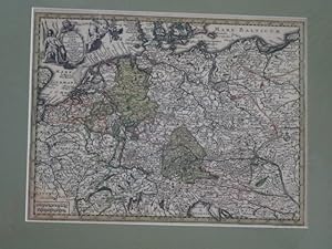
Kolorierte Kupferstichkarte - Imperium Romano-GErmanicum insuos circulos elect et Status suma cura et Studio divisum aeri insulpt. aus Atlas minor praecipua orbis terrarum imperia.
Editore: ohne Verlagsangabe, 1744
Lingua: Tedesco
Da: Antiquariat Buchseite, Purkersdorf, Austria
Valutazione del venditore 5 su 5 stelle

Mappa
ca 25,5 x 20 cm. Condizione: Gut. Erstauflage, EA. 1 Blatt sch�ne kolorierte Kupferstichkarte mit Titelkartusche hinter Pasepartout, mit Passepartout 40 x 30 cm, ohne Passepartout ca 25,5 x 20 cm, unten im linken Eck zarter Fleck, sonst guter Zustand Sprache: Deutsch Gewicht in Gramm: 1100.
-
Atlas Minor . (Frontespizio)
Editore: Frontespizio
Da: Sergio Trippini, Gavirate, VA, Italia
Membro dell'associazione: ALAI ILAB
Valutazione del venditore 4 su 5 stelle
EUR 120,00
Convertire valutaEUR 6,50 per la spedizione in ItaliaQuantit�: 1 disponibili
Aggiungi al carrelloIncisione, antica ed originale, raffigurante il frontespizio dell'opera "Atlas Minor praecipua Orbis Terrarum Imperia Regna et Provincias Germaniae Potissimum" pubblicata ad Augusta. La stampa, in coloritura coeva, � appilcata su margini anticamente riportati.
-
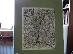
Kolorierte Kupferstichkarte - Alsatia Landgraviatus cum utroque Marchionatu Badensi Sundgovia Brisgovia. aus Atlas minor praecipua orbis terrarum imperia.
Editore: ohne Verlagsangabe, 1744
Lingua: Tedesco
Da: Antiquariat Buchseite, Purkersdorf, Austria
Valutazione del venditore 5 su 5 stelle
Mappa
ca 26,5 x 20 cm. Condizione: Gut. Erstauflage, EA. 1 Blatt sch�ne kolorierte Kupferstichkarte mit Titelkartusche hinter Pasepartout, mit Passepartout 40 x 30 cm, ohne Passepartout ca 26,5 x 20 cm, guter Zustand Sprache: Deutsch Gewicht in Gramm: 1100.
-
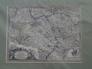
Kolorierte Kupferstichkarte - Platinatus Inferior sive Electoratus Palatinus ad Rhenum cum adjacentibus Archi Episcopatu Moguntino Episcop Spirensi et Wormatiensi.axon. aus Atlas minor praecipua orbis terrarum imperia.
Editore: ohne Verlagsangabe, 1744
Lingua: Tedesco
Da: Antiquariat Buchseite, Purkersdorf, Austria
Valutazione del venditore 5 su 5 stelle
Mappa
ca 25,5 x 20 cm. Condizione: Gut. Erstauflage, EA. 1 Blatt sch�ne kolorierte Kupferstichkarte mit Titelkartusche hinter Pasepartout, mit Passepartout 40 x 30 cm, ohne Passepartout ca 25,5 x 20 cm, guter Zustand Sprache: Deutsch Gewicht in Gramm: 1100.
-
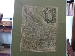
Kolorierte Kupferstichkarte - Circulus Bavaria in fuas quasq didion tam cum finitimis quam infertis Regionibus accuratissime divileri incis et venal exposit. aus Atlas minor praecipua orbis terrarum imperia.
Editore: ohne Verlagsangabe, 1744
Lingua: Tedesco
Da: Antiquariat Buchseite, Purkersdorf, Austria
Valutazione del venditore 5 su 5 stelle
Mappa
ca 25,5 x 20 cm. Condizione: Gut. Erstauflage, EA. 1 Blatt sch�ne kolorierte Kupferstichkarte mit Titelkartusche hinter Pasepartout, mit Passepartout 40 x 30 cm, ohne Passepartout ca 25,5 x 20 cm, guter Zustand Sprache: Deutsch Gewicht in Gramm: 1100.
-
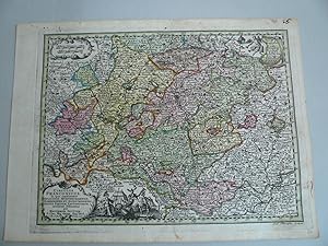
Franken-Circulus Franconicus, Seutter Matthaeus, Atlas Minor -anno 1740--- Franken-Circulus Franconicus, Seutter Matthaeus, Atlas Minor Altkoloriert, zeigt Franken, Blatt: 22 x 30 cm.
Data di pubblicazione: 1740
Da: Hammelburger Antiquariat, Hammelburg, Germania
Valutazione del venditore 5 su 5 stelle
Mappa
EUR 80,00
Convertire valutaEUR 11,00 per la spedizione da Germania a ItaliaQuantit�: 1 disponibili
Aggiungi al carrelloKein Einband. Condizione: Gut. Franken-Circulus Franconicus, Seutter Matthaeus, Atlas Minor -anno 1740--- Franken-Circulus Franconicus, Seutter Matthaeus, Atlas Minor Altkoloriert, zeigt Franken, Blatt: 22 x 30 cm.
-

Ierusalem, cum suburbiis, prout tempore Christi floruit . Abriss der Weltberuehmten Statt Ierusalem . nach dem Christ. Andrichomii abgezeichnet u. in Kupf(er) gestochen. Altkolorierter Kupferstich aus: Atlas minor. Praecipua orbis terrarum imperia.
Editore: Augsburg, Tobias Conrad Lotter, (ca. 1756)., 1756
Lingua: Tedesco
Da: Matthaeus Truppe Antiquariat, Graz, Austria
Membro dell'associazione: ILAB VDAO
Valutazione del venditore 4 su 5 stelle
Mappa
EUR 1.070,00
Convertire valutaEUR 20,00 per la spedizione da Austria a ItaliaQuantit�: 1 disponibili
Aggiungi al carrelloCa. 57 cm x 49 cm. Gerahmt. Die bei Tobias Lotter gedruckte zweite Auflage dieses Plans der Stadt Jerusalem im Altertum von Matth�us Seutter (erstmals in dessen "Atlas Novus" von 1741 gedruckt). - Der Plan basiert im Wesentlichen auf jenem von Christian van Adrichom des Jahres 1584. Im unteren Drittel eine "Beschreibung der Statt Jerusalem, samt einer Erkl�rung was eine jede Ziffer Zahl in diesem Abri� derselben bedeute". - Leicht fleckig. *** *** Copyright: Matthaeus TRUPPE Buchhandlung & Antiquariat - Stubenberggasse 7 - A-8010 Graz - ++43 (0)316 - 829552 *** *** Sprache: Deutsch Gewicht in Gramm: 0.
-
![Immagine del venditore per (Title Page to) Atlas minor praecipua orbis terrarum imperia, Regna et Provincias, Germaniae Potissimum, tabellis 50 exacte declineatis sistens usui militiae ducum ac peregrinantium maxime accomodatus opera Matthaei Seutteri, Sac. Caes. Maj. Geogr. Aug. Vind. Jacob Christoph Weyerman . Cum Privileg: S.R.I. Vicariat. in part: Rheni, Franc: et Suev Juris. Martin Gottfried Crophius Sculps. [Title Page to the Atlas Minor of the chief empires, kingdoms, and provinces of the world, especially of Germany, shown in 50 precisely drawn maps, most useful for military leaders and travelers] venduto da Antiqua Print Gallery](https://pictures.abebooks.com/inventory/md/md32317905728.jpg)
(Title Page to) Atlas minor praecipua orbis terrarum imperia, Regna et Provincias, Germaniae Potissimum, tabellis 50 exacte declineatis sistens usui militiae ducum ac peregrinantium maxime accomodatus opera Matthaei Seutteri, Sac. Caes. Maj. Geogr. Aug. Vind. Jacob Christoph Weyerman . Cum Privileg: S.R.I. Vicariat. in part: Rheni, Franc: et Suev Juris. Martin Gottfried Crophius Sculps. [Title Page to the Atlas Minor of the chief empires, kingdoms, and provinces of the world, especially of Germany, shown in 50 precisely drawn maps, most useful for military leaders and travelers]
Data di pubblicazione: 1744
Da: Antiqua Print Gallery, London, Regno Unito
Valutazione del venditore 3 su 5 stelle

Mappa
EUR 166,16
Convertire valutaEUR 46,09 per la spedizione da Regno Unito a ItaliaQuantit�: 1 disponibili
Aggiungi al carrelloCondizione: Good. Decorative hand coloured Title Page to Matth�us Seutter's Atlas Minor c1744 map. Antique 18th century copperplate map with original wash colour; Published by Matth�us Seutter & Jacob Christoph Weyerman. Jacob Christoph Weyerman Delin. Martin Gottfrid Crophius Sculp. (Undated but circa 1744). 21.5 x 29.5cm, 8.25 x 11.5 inches; this is a folding map. Condition: Good. There is nothing printed on the reverse side, which is plain. Engraved allegorical title page to Matth�us Seutter's Atlas Minor, introducing a suite of fifty small-format maps chiefly of the German lands but also of the wider world. Original wash colour, embellished with the instruments of geography and science. The design bears the privilege of the Holy Roman Empire and credits the engraver Martin Gottfried Crophius. Augsburg imprint with reference to the S.R.I. Vicariat, framed within a bold and richly ornamented Baroque architectural cartouche.
-

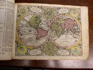
Planisphaerium coeleste. Diversi globi terr-aquei statione variante et visu intercedente, per coluros tropicoriorum. Per ambos polos et particul. sphaer� zenith in planum delineati orthographici prospectus. Quibus addita pro mutatione horizontis differentes sphaer� positiones earumque. Mutua cum circ. coelestibus convenientia et relatio, August� Vindelicor. cura et studio Matth. Seutteri, S. C. M. Geogr. C. Priv. S. R. I. Vicariat. A.C. Seutter delin. Andr. Silbereisen Sculps. (to accompany) Atlas minor praecipua orbis terrarum imperia. [Celestial Planisphere. Various representations of the terrestrial and aqueous globe, shown from differing positions and perspectives, through the tropic colures. An orthographic projection of both poles and particular zeniths of the sphere, drawn upon a plane. To which are added the differing positions of the spheres, corresponding to changes of the horizon, and their relationships. In mutual correspondence and relation with the celestial circles, prep
Data di pubblicazione: 1744
Da: Antiqua Print Gallery, London, Regno Unito
Valutazione del venditore 3 su 5 stelle
Mappa
EUR 830,82
Convertire valutaEUR 46,09 per la spedizione da Regno Unito a ItaliaQuantit�: 1 disponibili
Aggiungi al carrelloCondizione: Good. Diversi globi terr-aquei statione variante World Planisphere. Seutter c1744 map. Antique 18th century copperplate map with original wash colour; Published by Matth�us Seutter & Jacob Christoph Weyerman. Albrecht Carl Seutter Delin. Andreas Silbereisen Sculp. (Undated but circa 1744). 21.5 x 29.5cm, 8.25 x 11.5 inches; this is a folding map. Condition: Good. Please contact us if you would like to arrange to view this map. There is nothing printed on the reverse side, which is plain. Antique 18th-century copperplate planisphere by Matth�us Seutter. Original wash colour, framed by ornate Baroque cartouches and Latin descriptive panels. A magnificent double-hemisphere projection with supplementary orthographic views of both poles and zeniths, incorporating schematic representations of the terrestrial and celestial globes. The composition illustrates the principal cosmological systems of Descartes, Tycho Brahe, Ptolemy, and Copernicus, engraved by Andreas Silbereisen, and stands as one of Seutter's most didactic and decorative demonstrations of celestial geometry and Enlightenment scientific design. The terrestrial detail reflects both geographic discovery and enduring cartographic myth. California appears as an island; Tasmania lies isolated from the Australian mainland; and Hokkaido dwarfs Japan's main island, Honsh? In Asia, the legendary Lake Chiamay is depicted as the source of four great river systems, while in Central Africa, a vast inland lake gives rise to the Nile, Niger, and Congo, with the Niger improbably flowing westward to the Atlantic near Cape Verde. Off the Chilean coast, a "land discovered by David Anglum in 1680" is noted almost certainly a cartographic echo of Easter Island's first European sighting. A masterwork of scientific imagination and Baroque artistry, this engraving unites the known, the conjectured, and the mythical in a single, luminous vision of the 18th-century world.
-
(Atlas Minor) - Atlantis Minoris.
Da: Herman H. J. Lynge & S�n ILAB-ABF, Copenhagen, Danimarca
Membro dell'associazione: ABF ILAB
Valutazione del venditore 4 su 5 stelle
EUR 4.483,29
Convertire valutaEUR 35,00 per la spedizione da Danimarca a ItaliaQuantit�: 1 disponibili
Aggiungi al carrelloAugsburg, August� Vind, (1744). 4to-oblong. Cont. hcalf. Back and covers somewhat worn. Platesizes ca. 20,5 x 27 cm. (32) pp. and 60 full-page engraved maps (of 64 listed). Lacking the engraved title and 5 other maps (Africa, America septentrionalis, Regum Portugalli�, Regnum Hispani�, Italia totur and Pal�stina), but having 2 more not listed and some in the German section does not corresponds with the maps listed in the index. All maps in original handcolouring, occasionally a little brownspotted and traces of use in lower right corners. One map have a little loss of image in lower middle (Austria Saliburgensis). Phillips No 3494. 2 maps relating to America (Globus Terrestris (World Map) and America Meridionalis). Having maps of Europe, Asia, Russia, Turkey, Scandinavia etc. The World Map engraved by Andr. Silbereisen and most of the other maps engraved by A.C. Seutter and Tobias C. Lotter (married to Seutters daughter and his successor).