
Importo totale (1 articolo articoli):
Destinazione ordine:

large scale inch mile map (13 risultati)
Vai alla pagina principale dei risultati di ricerca
Filtri di ricerca
Tipo di articolo
- Tutti i tipi di prodotto
- Libri (9)
- Riviste e Giornali (Nessun altro risultato corrispondente a questo perfezionamento)
- Fumetti (Nessun altro risultato corrispondente a questo perfezionamento)
- Spartiti (Nessun altro risultato corrispondente a questo perfezionamento)
- Arte, Stampe e Poster (Nessun altro risultato corrispondente a questo perfezionamento)
- Fotografie (Nessun altro risultato corrispondente a questo perfezionamento)
- Mappe (4)
- Manoscritti e Collezionismo cartaceo (Nessun altro risultato corrispondente a questo perfezionamento)
Condizioni Maggiori informazioni
- Nuovo (Nessun altro risultato corrispondente a questo perfezionamento)
- Come nuovo, Ottimo o Quasi ottimo (Nessun altro risultato corrispondente a questo perfezionamento)
- Molto buono o Buono (7)
- Discreto o Mediocre (Nessun altro risultato corrispondente a questo perfezionamento)
- Come descritto (6)
Legatura
- Tutte
- Rilegato (Nessun altro risultato corrispondente a questo perfezionamento)
- Brossura (3)
Ulteriori caratteristiche
- Prima ed. (1)
- Copia autograf. (Nessun altro risultato corrispondente a questo perfezionamento)
- Sovracoperta (1)
- Con foto (9)
- Non Print on Demand (13)
Lingua (2)
Spedizione gratuita
- Spedizione gratuita in U.S.A. (Nessun altro risultato corrispondente a questo perfezionamento)
Paese del venditore
Valutazione venditore
-

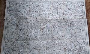
Ordnance Survey Map England and Wales. Large Series Sheet 125 . Scale : 1 inch to a mile Guildford and Horsham
Editore: Ordnance Survey Office / Edward Stanford, 1914
Da: Gwyn Tudur Davies, Aberystwyth, Regno Unito
Valutazione del venditore 5 su 5 stelle

Mappa
EUR 11,88
Spedizione EUR 14,41
Spedito da Regno Unito a U.S.A.Quantit�: 1 disponibili
Aggiungi al carrelloSoft cover. Condizione: Good. Condizione sovraccoperta: Good. 3rd Edition. 1 folded folded cloth map. Some annotations and small stain on on covers o/w the map itself is clean unmarked and in very good condition. Railways revised in 1914. e1030 / m11766.
-

Ordnance Survey (Large Sheet Series) Map of England & Wales, Sheet 67: Norwich. Scale: 1 Inch. to a Mile
Editore: The Ordnance Survey, 1912
Da: Paul Hughes - PBFA, Bishop Auckland, Regno Unito
Membro dell'associazione: PBFA
Valutazione del venditore 5 su 5 stelle
Mappa
EUR 14,25
Spedizione EUR 27,68
Spedito da Regno Unito a U.S.A.Quantit�: 1 disponibili
Aggiungi al carrelloSoft cover. Condizione: Very Good. Linen-backed folding map. Some foxing to linen. Name of a Corporal of the London Rifle Brigade inscribed on front cover (1915).
-
Greenaway's New Large Scale Touring and Motoring Road Map of Swindon with 2 mile circles Half inch to the mile
Lingua: Inglese
Editore: C.B. Greenaway, Swindon, 1930
Da: Your Book Soon, Stroud, GLOS, Regno Unito
Valutazione del venditore 5 su 5 stelle
Mappa
EUR 15,20
Spedizione EUR 21,85
Spedito da Regno Unito a U.S.A.Quantit�: 1 disponibili
Aggiungi al carrelloMap. Condizione: Good. 2nd Edition. Folding, linen backed, coloured roads 45 x 58 cm. Undated C 1930 Map tanned some splits and tears at folds, covers marked.
-
Ordnance Survey Map England & Wales Large Series Scale;1 inch to a Mile
Editore: Edward Stanford Ltd
Da: Chapter 1, Johannesburg, GAU, Sudafrica
Valutazione del venditore 5 su 5 stelle
EUR 10,77
Spedizione EUR 25,00
Spedito da Sudafrica a U.S.A.Quantit�: 1 disponibili
Aggiungi al carrelloCondizione: Good. 1912. Wraps are worn and marked.Internally clean.Well bound.Map.[RK]. Our orders are shipped using tracked courier delivery services.
-
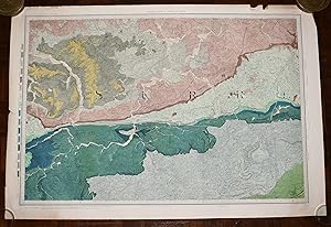
Large Hand Coloured Geological Ordnance Survey MAP SHEET 12 Basingstoke Hampshire Geological Survey of England & Wales Scale 1 inch to 1 mile.
Editore: Geological Survey of England & Wales Colonel Colby 1860 Revised 1885, 1885
Da: PROCTOR / THE ANTIQUE MAP & BOOKSHOP, DORCHESTER, Regno Unito
Membro dell'associazione: PBFA
Valutazione del venditore 5 su 5 stelle
EUR 23,75
Spedizione EUR 23,06
Spedito da Regno Unito a U.S.A.Quantit�: 1 disponibili
Aggiungi al carrelloOriginal rolled flat map. Hand-coloured engraving With ORDNANCE SURVEY Blind Stamp top margin. Size 33.5 inches X 26.5 inches. 84cm x 66cm Ordnance survey map showing Basingstoke, Whitchurch, Andover & surrounding areas. In good condition. Some foxing & a little dusty on margins & tear on right hand side of map. A few small nicks top edge. Unfolded. It will be rolled up and posted in a poster tube.
-

Large Hand Coloured Geological Ordnance Survey MAP SHEET 47 S.W Essex Geological Survey of England & Wales Scale 1 inch to 1 mile.
Editore: Geological Survey of England & Wales 1884, 1884
Da: PROCTOR / THE ANTIQUE MAP & BOOKSHOP, DORCHESTER, Regno Unito
Membro dell'associazione: PBFA
Valutazione del venditore 5 su 5 stelle
EUR 26,13
Spedizione EUR 23,06
Spedito da Regno Unito a U.S.A.Quantit�: 1 disponibili
Aggiungi al carrelloOriginal rolled flat map. Hand-coloured engraving With ORDNANCE SURVEY Blind Stamp top margin. Size 40 inches X 26.5 inches. 100cm x 68cm Ordnance survey map showing Saffron Walden, Whitham, Royston & surrounding areas. In generally good condition. Some foxing & a little dusty on margins & right hand side. A few small nicks on edges, a little tatty top left corner. Unfolded. It will be rolled up and posted in a poster tube.
-
Heane's Large Scale Cycling, Touring and Driving Map of Sixty Miles about Preston with one mile circles . Half an inch to a Mile
Editore: W S Heane (Preston), GB, 1899
Da: Richard Sylvanus Williams (Est 1976), WINTERTON, Regno Unito
Valutazione del venditore 5 su 5 stelle
EUR 13,45
Spedizione EUR 36,90
Spedito da Regno Unito a U.S.A.Quantit�: 1 disponibili
Aggiungi al carrelloPaperback. Condizione: Good. Not dated but perhaps about 1899. Extends to 760 x 120 mm. Folds to 150 x 80 mm. Black and white map (on cloth) of Preston and 30 mile radius out. Roads printed in brown. Very worn but no major faults.
-
Large Hand Coloured Geological Ordnance Survey MAP SHEET 8 Guildford SURREY Geological Survey of England & Wales Scale 1 inch to 1 mile.
Editore: Geological Survey of England & Wales Colonel Colby 1816 Revised 1891, 1891
Da: PROCTOR / THE ANTIQUE MAP & BOOKSHOP, DORCHESTER, Regno Unito
Membro dell'associazione: PBFA
Valutazione del venditore 5 su 5 stelle
EUR 33,26
Spedizione EUR 23,06
Spedito da Regno Unito a U.S.A.Quantit�: 1 disponibili
Aggiungi al carrelloOriginal rolled flat map. Hand-coloured engraving With ORDNANCE SURVEY Blind Stamp top margin. Size 33.5 inches X 26 inches. 85cm x 66cm Ordnance survey map showing Guildford & surrounding areas. In good condition. Some foxing & a little dusty on margins. Margin has small tear on left, crease down right hand margin, Top edge a little nicked with one tear. MAP not affected by edge nicks etc. Unfolded. It will be rolled up and posted in a poster tube.
-

Large Hand Coloured Geological Ordnance Survey MAP SHEET 12 Basingstoke Hampshire Geological Survey of England & Wales Scale 1 inch to 1 mile.
Editore: Geological Survey of England & Wales Colonel Colby 1860 Revised 1885, 1885
Da: PROCTOR / THE ANTIQUE MAP & BOOKSHOP, DORCHESTER, Regno Unito
Membro dell'associazione: PBFA
Valutazione del venditore 5 su 5 stelle
EUR 39,20
Spedizione EUR 23,06
Spedito da Regno Unito a U.S.A.Quantit�: 1 disponibili
Aggiungi al carrelloOriginal rolled flat map. Hand-coloured engraving With ORDNANCE SURVEY Blind Stamp top margin. Size 32.5 inches X 27.5 inches. 82cm x 70cm Ordnance survey map showing Basingstoke, Whitchurch, Andover & surrounding areas. In good condition. Some foxing & a little dusty on margins & slightly on right hand side of map. A few small nicks lower edge. Unfolded. It will be rolled up and posted in a poster tube.
-
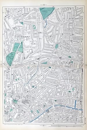
LONDON, 1909 - HIGHBURY, HOXTON, STOKE NEWINGTON, KINGSLAND, Original Antique Map from Bacons London & Suburbs, Large 9 inch per Mile Scale.
Editore: G.W. Bacon, 1909
Da: End of The World Maps., Penzance, Regno Unito
Valutazione del venditore 4 su 5 stelle

Mappa
EUR 59,39
Spedizione EUR 11,53
Spedito da Regno Unito a U.S.A.Quantit�: 1 disponibili
Aggiungi al carrelloNo Binding. Condizione: Very Good. Original Antique Map / Plan of London - HIGHBURY, HOXTON, STOKE NEWINGTON, KINGSLAND : Large scale, 9 inches to the mile, street plan / map, sourced from the New Large Scale Atlas of London & Suburbs, published by G.W. Bacon, London. PRINTED IN : 1909. SIZE : Folio : approx 51 x 33 cm, (20" x 13"), IMAGE SIZE: Approx 45 x 30 cm, (18" x 12") NOTES ON CONDITION: A large Original Map in Very Good condition, suitable for framing. Sheet map with centre fold, normal guide remains to verso else clear. Minor aging /marking consistent with light usage only. PACKAGING AND SHIPMENT: - The map is placed in a clear polypropylene protective sleeve, and shipped in an extra strong postal tube. DECLARATION of AUTHENTICITY - We guarantee the map to be an authentic historic map, published at the date stated above. We do not sell reproductions. We include a photograph of the Atlas the map has been sourced from as evidence of its provenance. A Certificate of Authenticity accompanies the map. Important Notes :- - the listing is for the map as described only , any photo's showing the atlas from where the map came from is for information / provenance purposes only. - any watermarking to the photographs above is not , of course, present on the actual map ! - virtually all antiquarian maps and prints are subject to some normal aging due to use and time which is not obtrusive unless otherwise stated. - most higher quality 19th C atlas's mounted maps on "guides" , traces of this will often remain to the back , with no significant detrimental effect to the map itself.
-

Large Hand Coloured Geological Ordnance Survey MAP SHEET 7 LONDON including River Thames Middlesex Geological Survey of England & Wales Scale 1 inch to 1 mile.
Editore: Geological Survey of England & Wales Colonel Colby 1822 Revised 1885, 1885
Da: PROCTOR / THE ANTIQUE MAP & BOOKSHOP, DORCHESTER, Regno Unito
Membro dell'associazione: PBFA
Valutazione del venditore 5 su 5 stelle
EUR 65,33
Spedizione EUR 23,06
Spedito da Regno Unito a U.S.A.Quantit�: 1 disponibili
Aggiungi al carrelloOriginal rolled flat map. Hand-coloured engraving With ORDNANCE SURVEY Blind Stamp top margin. Size 39.5 inches X 27 inches. 100cm x 69cm Ordnance survey map showing Uxbridge, Windsor, Watford Chelsea & surrounding areas. In generally good condition. Some foxing & a little dusty on margins & 2 tears together on top edge of map. A few small nicks on edges. Unfolded. It will be rolled up and posted in a poster tube.
-
The County of Suffolk, Reduced from the Large Map in Six Sheets Surveyed by Joseph Hodskinson & planned from the Scale of Half an Inch to One Mile.
Editore: Printed for Willm. Faden, Geographer to the King, Charing Cross, Jany. 1st,, 1787
Da: Claude Cox Old & Rare Books ABA, ILAB, Saxmundham, Regno Unito
Membro dell'associazione: ABA ILAB PBFA
Valutazione del venditore 5 su 5 stelle
EUR 296,94
Spedizione EUR 17,30
Spedito da Regno Unito a U.S.A.Quantit�: 1 disponibili
Aggiungi al carrello585 x 785mm., copper-engraved map, dissected and mounted on linen with contemporary hand-colouring; well preserved in original pastepaper sleeve with Faden's printed label and Ipswich bookseller'sl label of, '.C. Battely, Bookseller &c. Cornhill, Ipswich.' A very good copy of this rare one sheet reduction (to half an inch to 1 statute mile) of Hodskinson's large-scale map of Suffolk. Engraved by William Faden, with information on market towns, parishes, churches and chapels, seats or noted houses, parks, enclosed roads, open roads, farms, and cottages. Map 18thC dissected SUFFOLK.
-
[Large Map on Linen of North Wales] To Sir Watkin Williams-Wynn Bart. LLD, Member Of Parliament, Lord Lieutenant And Custos Rotulorum Of The Counties Of Denbigh. This Map Of The Six Counties Of North-Wales.Scale: 3/4 inch to one statute mile
Editore: Lwynygroes, Wales, 1795
Da: Polar Books, Llandudno, CONWY, Regno Unito
Valutazione del venditore 5 su 5 stelle
Prima edizione
EUR 5.166,68
Spedizione EUR 28,83
Spedito da Regno Unito a U.S.A.Quantit�: 1 disponibili
Aggiungi al carrelloLinen Map. Condizione: Good. Condizione sovraccoperta: No Dust Jacket. First Edition. 1795 Map: To Sir Watkin Williams-Wynn Bart. LLD, Member Of Parliament, Lord Lieutenant And Custos Rotulorum Of The Counties Of Denbigh And Merioneth, Colonel Of The Ancient British Fencible Cavalry, Steward Of The Hundreds Of Bromfield And Yal And Vice President Of The Welsh Charity School This Map Of The Six Counties Of North-Wales Is Most Humbly Inscribed By His Obedient Humble Servant John Evans. Evans' large-scale map engraved map of North Wales, dissected and laid on lined. Scale: 3/4 inch to one statute mile (1:190080). In 3 sections. 2 sections approx 54cm x 180cm, 1 section 50cm x 180cm, total size approx 158cm x 180cm. Scale 3/4 inch to one statute mile. No slip case. Montgomery Welshpool in ink on reverse of linen on one section. Border a little worn in places. The small population of the area combined with the mountainous terrain predetermined the type of map that would result from Evans' survey, a task that must have proved enormous over such difficult ground. The thoroughness of this survey is indicated by the way he continues the detail on the east of the map, into Cheshire and Shropshire. The engraver of the map, Robert Baugh, adopted a similar approach for the only other large-scale survey he was involved in, that of Shropshire. The left hand sheet has an engraving Vale Crucis Abbey and the dedication to Sir Watkin William Wynn, Lord Lieutenant of Denbigh and Merioneth, who purchased 100 copies himself. With hills and mountains dominating the map. The top right has a lovely engraving of a bird of prey holding the Compass Arrow pointing north. The largest map to appear prior to the publication of the Ordnance Survey, it is surprising Evans' only major cartographical contribution: a highly competent survey that deservedly received recognition from the Society of Arts. Roger 559. Quantity Available: 1. Shipped Weight: Under 1 kilogram. Category: Geography & Maps; Geography & Maps. Pictures of this item not already displayed here available upon request. Inventory No: 3985.


![Immagine del venditore per [Large Map on Linen of North Wales] To Sir Watkin Williams-Wynn Bart. LLD, Member Of Parliament, Lord Lieutenant And Custos Rotulorum Of The Counties Of Denbigh. This Map Of The Six Counties Of North-Wales.Scale: 3/4 inch to one statute mile venduto da Polar Books](https://pictures.abebooks.com/inventory/md/md32111201624.jpg)