Importo totale (1 articolo articoli):
Destinazione ordine:

stanfords library map london suburbs di stanford (25 risultati)
Feedback
Vai alla pagina principale dei risultati di ricerca
Filtri di ricerca
Tipo di articolo
- Tutti i tipi di prodotto
- Libri (3)
- Riviste e Giornali (Nessun altro risultato corrispondente a questo perfezionamento)
- Fumetti (Nessun altro risultato corrispondente a questo perfezionamento)
- Spartiti (Nessun altro risultato corrispondente a questo perfezionamento)
- Arte, Stampe e Poster (Nessun altro risultato corrispondente a questo perfezionamento)
- Fotografie (Nessun altro risultato corrispondente a questo perfezionamento)
- Mappe (22)
- Manoscritti e Collezionismo cartaceo (Nessun altro risultato corrispondente a questo perfezionamento)
Condizioni
- Tutte
- Nuovi (Nessun altro risultato corrispondente a questo perfezionamento)
- Antichi o usati (25)
Legatura
Ulteriori caratteristiche
- Prima ed. (1)
- Copia autograf. (Nessun altro risultato corrispondente a questo perfezionamento)
- Sovracoperta (Nessun altro risultato corrispondente a questo perfezionamento)
- Con foto (23)
- Non Print on Demand (25)
Lingua (2)
Prezzo
- Qualsiasi prezzo
- Inferiore a EUR 20 (Nessun altro risultato corrispondente a questo perfezionamento)
- EUR 20 a EUR 45 (Nessun altro risultato corrispondente a questo perfezionamento)
- Superiore a EUR 45
Spedizione gratuita
- Spedizione gratuita in Italia (Nessun altro risultato corrispondente a questo perfezionamento)
Paese del venditore
Valutazione venditore
-

EUR 108,69
Convertire valutaEUR 37,59 per la spedizione da Regno Unito a ItaliaQuantit�: 1 disponibili
Aggiungi al carrelloCondizione: Good. This is an ex-library book and may have the usual library/used-book markings inside.This book has soft covers. In good all round condition. Please note the Image in this listing is a stock photo and may not match the covers of the actual item,350grams, ISBN:0903541335.
-

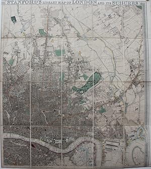
Stanford's library map of London and its suburbs. 24 sheets, on the scale of six inches to a mile. Introductory Notes by Ralph Hyde.
Editore: Lympne Castle, Harry Margary in association with Guildhall Library,, 1980
Da: Cobnar Books, Deal, Regno Unito
Membro dell'associazione: PBFA
Valutazione del venditore 5 su 5 stelle

EUR 208,33
Convertire valutaEUR 11,72 per la spedizione da Regno Unito a ItaliaQuantit�: 1 disponibili
Aggiungi al carrelloPublisher's hardback binding with a paper label to the front board. 38.5x46 cms A very good copy. Scarce.
-
Stanford's Library Map of London and it's Suburbs, 24 Sheets, On the Scale of Six Inches to a Mile
Editore: Harry Margary, Kent, 1980
Da: Rooke Books PBFA, Bath, Regno Unito
Membro dell'associazione: PBFA
Valutazione del venditore 5 su 5 stelle
EUR 90,57
Convertire valutaEUR 11,71 per la spedizione da Regno Unito a ItaliaQuantit�: 1 disponibili
Aggiungi al carrelloLoose Pages, Articles. Condizione: Near Fine. None (illustratore). A wonderful new edition of Edward Stanford's renowned map of London, featuring introductory notes by Ralph Hyde. A scarce new edition. Unbound, loose and rolled. A smart facsimile of Edward Stanford's important and detailed map of London and it surrounding suburbs. With an introduction by Ralph Hyde. This map was first published in 1862, and was so popular that it is still in print today. Edward Stanford set our to create to most accurate map of London possible, resulting in this brilliantly detailed map, printed across twenty four sheets on a scale of six inches to a mile. Offering a unique insight into Victorian London, during rapid expansion and change in the city due to the Industrial Revolution. Complete with twenty-four sheets of maps. Unbound, loose and rolled. In very smart condition. Pages very bright and clean. Some scattered handling marks to the title sheet and to the reverse of the final map. Some creasing to the lower corner of the final map. Near Fine. book.
-
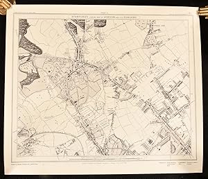
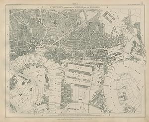
'STANFORD'S LIBRARY MAP OF LONDON AND IT'S SUBURBS' - ( Sheet 8). Old Ford, Victoria Park, Hackney Wick, Wanstead, Stratford New Town, West Ham, Bow. Site of 2012 Olympic Games.
Editore: Edward Stanford ca. 1890, 1890
Da: Garwood & Voigt, Sevenoaks, Regno Unito
Valutazione del venditore 5 su 5 stelle
Mappa
EUR 108,69
Convertire valutaEUR 28,14 per la spedizione da Regno Unito a ItaliaQuantit�: 1 disponibili
Aggiungi al carrelloCondizione: Fine. 33 x 41 cm. Original coloured plan.
-
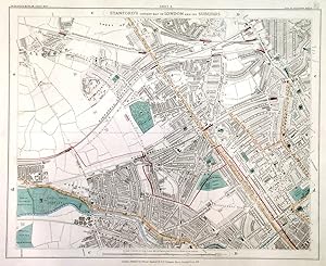
'STANFORD'S LIBRARY MAP OF LONDON AND IT'S SUBURBS' - ( Sheet 24). Lower Sydenham, Beckenham, Bromley, South End, Perry Vale.
Editore: Edward Stanford ca. 1890, 1890
Da: Garwood & Voigt, Sevenoaks, Regno Unito
Valutazione del venditore 5 su 5 stelle
Mappa
EUR 120,77
Convertire valutaEUR 28,14 per la spedizione da Regno Unito a ItaliaQuantit�: 1 disponibili
Aggiungi al carrelloCondizione: Fine. 33 x 41 cm. Original coloured plan.
-

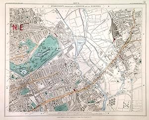
'STANFORD'S LIBRARY MAP OF LONDON AND IT'S SUBURBS' - ( Sheet 4). Walthamstow, Leyton, Lea Bridge Road.
Editore: Edward Stanford ca. 1890, 1890
Da: Garwood & Voigt, Sevenoaks, Regno Unito
Valutazione del venditore 5 su 5 stelle
Mappa
EUR 120,77
Convertire valutaEUR 28,14 per la spedizione da Regno Unito a ItaliaQuantit�: 1 disponibili
Aggiungi al carrelloCondizione: Fine. 33 x 41 cm. Original coloured plan.
-
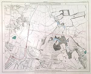
'STANFORD'S LIBRARY MAP OF LONDON AND IT'S SUBURBS' - ( Sheet 5). Kensal Green, Willesden, Kilburn, St John's Wood, Paddington.
Editore: Edward Stanford ca. 1890, 1890
Da: Garwood & Voigt, Sevenoaks, Regno Unito
Valutazione del venditore 5 su 5 stelle
Mappa
EUR 181,15
Convertire valutaEUR 28,14 per la spedizione da Regno Unito a ItaliaQuantit�: 1 disponibili
Aggiungi al carrelloCondizione: Fine. 33 x 41 cm. Original coloured plan.
-
Stanford's Library Map of London and Its Suburbs.
Editore: Edward Sandford, 1862., 1862
Da: Michael S. Kemp, Bookseller, Sheerness, KENT, Regno Unito
Membro dell'associazione: PBFA
Valutazione del venditore 4 su 5 stelle

Mappa Prima edizione
EUR 1.690,73
Convertire valutaEUR 11,72 per la spedizione da Regno Unito a ItaliaQuantit�: 1 disponibili
Aggiungi al carrello2 parts only of 4. Each sheet 975 x 865 mm. hand coloured mounted on linen in sections. A fine clean example. The first edition of Stanford's attractive large scale map of London, these two maps cover the whole of North London, a further two maps covering the south of the city were published slightly later.
-
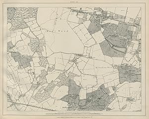
Stanford's Library map of London and its suburbs - Sheet 30
Data di pubblicazione: 1895
Da: Antiqua Print Gallery, London, Regno Unito
Valutazione del venditore 3 su 5 stelle

Mappa
EUR 72,46
Convertire valutaEUR 35,17 per la spedizione da Regno Unito a ItaliaQuantit�: 1 disponibili
Aggiungi al carrelloCondizione: Good. Stanford Library map of London Sheet 30 West Wood Blendon Wood Blackfen 1895. Antique street map of part of London; Edward Stanford (These maps are undated. From the content we date them at circa 1895, although the western extensions of maps 1, 5, 9, 13, 17 & 21 appear to be earlier. Key dating references include the presence of Tower Bridge (opened 1894) and Rosebery Avenue (1892) and the absence of the Blackwall Tunnel (opened 1897) and the Boundary Estate (1896)). 34.5 x 43.5cm, 13.75 x 17 inches. Condition: Good. There is nothing printed on the reverse side, which is plain. Sheet 30 West Wood, Blendon Wood, Avery Hill, Blackfen, Welling, Falconwood.
-
Stanford's Library map of London and its suburbs - Sheet 4
Data di pubblicazione: 1877
Da: Antiqua Print Gallery, London, Regno Unito
Valutazione del venditore 3 su 5 stelle
Mappa
EUR 96,61
Convertire valutaEUR 35,17 per la spedizione da Regno Unito a ItaliaQuantit�: 1 disponibili
Aggiungi al carrelloCondizione: Good. Stanford's Library map of London Sheet 4 Leyton Leytonstone Hackney Marshes 1877. Antique street map of part of London, overlaid with geological detail in original hand colour; Edward Stanford (1877). 35.0 x 43.0cm, 13.75 x 17 inches; this is a folding map. Condition: Good. There is nothing printed on the reverse side, which is plain.
-
Stanford's Library map of London and its suburbs - Sheet 31
Data di pubblicazione: 1895
Da: Antiqua Print Gallery, London, Regno Unito
Valutazione del venditore 3 su 5 stelle
Mappa
EUR 108,69
Convertire valutaEUR 35,17 per la spedizione da Regno Unito a ItaliaQuantit�: 1 disponibili
Aggiungi al carrelloCondizione: Good. Stanford Library map of London Sheet 31 Mottingham Chislehurst Bromley 1895. Antique street map of part of London; Edward Stanford (These maps are undated. From the content we date them at circa 1895, although the western extensions of maps 1, 5, 9, 13, 17 & 21 appear to be earlier. Key dating references include the presence of Tower Bridge (opened 1894) and Rosebery Avenue (1892) and the absence of the Blackwall Tunnel (opened 1897) and the Boundary Estate (1896)). 35.0 x 43.0cm, 13.75 x 17 inches. Condition: Good. Blemish in margin. There is nothing printed on the reverse side, which is plain. Sheet 31 Mottingham, Chislehurst, Grove Park, Bromley, Elmstead, Sundridge Park.
-
Stanford's Library map of London and its suburbs - Sheet 25
Data di pubblicazione: 1895
Da: Antiqua Print Gallery, London, Regno Unito
Valutazione del venditore 3 su 5 stelle
Mappa
EUR 108,69
Convertire valutaEUR 35,17 per la spedizione da Regno Unito a ItaliaQuantit�: 1 disponibili
Aggiungi al carrelloCondizione: Good. Stanford Library map of London Sheet 25 Canning Town Royal Docks Woolwich 1895. Antique street map of part of London; Edward Stanford (These maps are undated. From the content we date them at circa 1895, although the western extensions of maps 1, 5, 9, 13, 17 & 21 appear to be earlier. Key dating references include the presence of Tower Bridge (opened 1894) and Rosebery Avenue (1892) and the absence of the Blackwall Tunnel (opened 1897) and the Boundary Estate (1896)). 31.5 x 43.5cm, 12.25 x 17.25 inches. Condition: Good. There is nothing printed on the reverse side, which is plain. Sheet 25 Canning Town, Silvertown, Woolwich, Royal Docks, Victoria Dock, [City Airport], Custom House.
-
Stanford's Library map of London and its suburbs - Sheet 32
Data di pubblicazione: 1895
Da: Antiqua Print Gallery, London, Regno Unito
Valutazione del venditore 3 su 5 stelle
Mappa
EUR 108,69
Convertire valutaEUR 35,17 per la spedizione da Regno Unito a ItaliaQuantit�: 1 disponibili
Aggiungi al carrelloCondizione: Good. Stanford Library map of London Sheet 32 Chislehurst Foots Cray Sidcup 1895. Antique street map of part of London; Edward Stanford (These maps are undated. From the content we date them at circa 1895, although the western extensions of maps 1, 5, 9, 13, 17 & 21 appear to be earlier. Key dating references include the presence of Tower Bridge (opened 1894) and Rosebery Avenue (1892) and the absence of the Blackwall Tunnel (opened 1897) and the Boundary Estate (1896)). 35.0 x 43.5cm, 13.75 x 17 inches. Condition: Good. There is nothing printed on the reverse side, which is plain. Sheet 32 Chislehurst, Foots Cray, Longlands, Ruxley, Sidcup.
-
Stanford's Library map of London and its suburbs - Sheet 26
Data di pubblicazione: 1895
Da: Antiqua Print Gallery, London, Regno Unito
Valutazione del venditore 3 su 5 stelle
Mappa
EUR 108,69
Convertire valutaEUR 35,17 per la spedizione da Regno Unito a ItaliaQuantit�: 1 disponibili
Aggiungi al carrelloCondizione: Good. Stanford Library map of London Sheet 26 Woolwich Beckton Thamesmead 1895. Antique street map of part of London; Edward Stanford (These maps are undated. From the content we date them at circa 1895, although the western extensions of maps 1, 5, 9, 13, 17 & 21 appear to be earlier. Key dating references include the presence of Tower Bridge (opened 1894) and Rosebery Avenue (1892) and the absence of the Blackwall Tunnel (opened 1897) and the Boundary Estate (1896)). 31.0 x 43.5cm, 12.25 x 17 inches. Condition: Good. There is nothing printed on the reverse side, which is plain. Sheet 26 Woolwich, Beckton, Creekmouth, Thamesmead, Gallions Reach, Barking Reach, Plumstead Marshes.
-
Stanford's Library map of London and its suburbs - Sheet 28
Data di pubblicazione: 1895
Da: Antiqua Print Gallery, London, Regno Unito
Valutazione del venditore 3 su 5 stelle
Mappa
EUR 108,69
Convertire valutaEUR 35,17 per la spedizione da Regno Unito a ItaliaQuantit�: 1 disponibili
Aggiungi al carrelloCondizione: Good. Stanford Library map of London Sheet 28 Plumstead East Wickham Abbey Wood 1895. Antique street map of part of London; Edward Stanford (These maps are undated. From the content we date them at circa 1895, although the western extensions of maps 1, 5, 9, 13, 17 & 21 appear to be earlier. Key dating references include the presence of Tower Bridge (opened 1894) and Rosebery Avenue (1892) and the absence of the Blackwall Tunnel (opened 1897) and the Boundary Estate (1896)). 35.0 x 43.5cm, 13.75 x 17 inches. Condition: Good. Blemish. There is nothing printed on the reverse side, which is plain. Sheet 28 Plumstead, East Wickham, Royal Arsenal, Abbey Wood, West Heath.
-
Stanford's Library map of London and its suburbs - Index map
Data di pubblicazione: 1895
Da: Antiqua Print Gallery, London, Regno Unito
Valutazione del venditore 3 su 5 stelle
Mappa
EUR 108,69
Convertire valutaEUR 35,17 per la spedizione da Regno Unito a ItaliaQuantit�: 1 disponibili
Aggiungi al carrelloCondizione: Good. Stanford's Library map of London - Index Map 1895 old antique plan chart. Antique street map of part of London on hardboard cover; Edward Stanford (These maps are undated. From the content we date them at circa 1895, although the western extensions of maps 1, 5, 9, 13, 17 & 21 appear to be earlier. Key dating references include the presence of Tower Bridge (opened 1894) and Rosebery Avenue (1892) and the absence of the Blackwall Tunnel (opened 1897) and the Boundary Estate (1896)). 35.5 x 44.5cm, 14 x 17.5 inches. Condition: Good. Light soiling. There is nothing printed on the reverse side, which is plain. Index Map.
-
Stanford's Library map of London and its suburbs - Sheet 8
Data di pubblicazione: 1895
Da: Antiqua Print Gallery, London, Regno Unito
Valutazione del venditore 3 su 5 stelle
Mappa
EUR 144,92
Convertire valutaEUR 35,17 per la spedizione da Regno Unito a ItaliaQuantit�: 1 disponibili
Aggiungi al carrelloCondizione: Good. Stanford Library map of London Sheet 8 Hackney Wick Bow Stratford West Ham 1895. Antique street map of part of London; Edward Stanford (These maps are undated. From the content we date them at circa 1895, although the western extensions of maps 1, 5, 9, 13, 17 & 21 appear to be earlier. Key dating references include the presence of Tower Bridge (opened 1894) and Rosebery Avenue (1892) and the absence of the Blackwall Tunnel (opened 1897) and the Boundary Estate (1896)). 35.0 x 43.0cm, 13.75 x 17 inches. Condition: Good. Repaired marginal tear. Please contact us if you would like to arrange to view this map. There is nothing printed on the reverse side, which is plain. Sheet 8 Victoria Park, Old Ford, Hackney Wick, Bow, Stratford, Bethnal Green, Mile End.
-
Stanford's Library map of London and its suburbs - Sheet 12
Data di pubblicazione: 1895
Da: Antiqua Print Gallery, London, Regno Unito
Valutazione del venditore 3 su 5 stelle
Mappa
EUR 181,15
Convertire valutaEUR 35,17 per la spedizione da Regno Unito a ItaliaQuantit�: 1 disponibili
Aggiungi al carrelloCondizione: Good. Stanford Library map of London Sheet 12 Tower Hamlets Limehouse Isle/Dogs 1895. Antique street map of part of London; Edward Stanford (These maps are undated. From the content we date them at circa 1895, although the western extensions of maps 1, 5, 9, 13, 17 & 21 appear to be earlier. Key dating references include the presence of Tower Bridge (opened 1894) and Rosebery Avenue (1892) and the absence of the Blackwall Tunnel (opened 1897) and the Boundary Estate (1896)). 35.5 x 43.5cm, 14 x 17 inches. Condition: Good. Blemish in margin. Please contact us if you would like to arrange to view this map. There is nothing printed on the reverse side, which is plain. Sheet 12 Limehouse, Poplar, West and East India Docks, Isle of Dogs, North Greenwich, Tower Hamlets, Surrey Quays, Rotherhithe, Millwall.
-
Stanford's Library map of London and its suburbs - Sheet 15
Data di pubblicazione: 1895
Da: Antiqua Print Gallery, London, Regno Unito
Valutazione del venditore 3 su 5 stelle
Mappa
EUR 181,15
Convertire valutaEUR 35,17 per la spedizione da Regno Unito a ItaliaQuantit�: 1 disponibili
Aggiungi al carrelloCondizione: Good. Stanford Library map of London Sheet 15 Walworth Camberwell Peckham 1895. Antique street map of part of London; Edward Stanford (These maps are undated. From the content we date them at circa 1895, although the western extensions of maps 1, 5, 9, 13, 17 & 21 appear to be earlier. Key dating references include the presence of Tower Bridge (opened 1894) and Rosebery Avenue (1892) and the absence of the Blackwall Tunnel (opened 1897) and the Boundary Estate (1896)). 35.5 x 43.5cm, 14 x 17 inches. Condition: Good. Blemish in margin. Please contact us if you would like to arrange to view this map. There is nothing printed on the reverse side, which is plain. Sheet 15 Walworth, Camberwell, Peckham, Bermondsey, Kennington, Denmark Hill.
-
Stanford's Library map of London and its suburbs - Sheet 21 & Sheet 21a
Data di pubblicazione: 1895
Da: Antiqua Print Gallery, London, Regno Unito
Valutazione del venditore 3 su 5 stelle
Mappa
EUR 217,38
Convertire valutaEUR 35,17 per la spedizione da Regno Unito a ItaliaQuantit�: 1 disponibili
Aggiungi al carrelloCondizione: Good. Stanford Library map of London Sheet 21/21a Wimbledon Cottenham Park Merton 1895. Antique street map of part of London; Edward Stanford (These maps are undated. From the content we date them at circa 1895, although the western extensions of maps 1, 5, 9, 13, 17 & 21 appear to be earlier. Key dating references include the presence of Tower Bridge (opened 1894) and Rosebery Avenue (1892) and the absence of the Blackwall Tunnel (opened 1897) and the Boundary Estate (1896)). 36.0 x 63.0cm, 14 x 24.75 inches; this is a folding map. Condition: Good. Blemish in margin. Please contact us if you would like to arrange to view this map. There is nothing printed on the reverse side, which is plain. Sheet 21 Wimbledon, Merton, Raynes Park & Sheet 21a Cottenham Park.
-
Stanford's Library map of London and its suburbs - Sheet 18
Data di pubblicazione: 1895
Da: Antiqua Print Gallery, London, Regno Unito
Valutazione del venditore 3 su 5 stelle
Mappa
EUR 217,38
Convertire valutaEUR 35,17 per la spedizione da Regno Unito a ItaliaQuantit�: 1 disponibili
Aggiungi al carrelloCondizione: Good. Stanford Library map of London Sheet 18 Clapham Balham Tooting Brixton 1895. Antique street map of part of London; Edward Stanford (These maps are undated. From the content we date them at circa 1895, although the western extensions of maps 1, 5, 9, 13, 17 & 21 appear to be earlier. Key dating references include the presence of Tower Bridge (opened 1894) and Rosebery Avenue (1892) and the absence of the Blackwall Tunnel (opened 1897) and the Boundary Estate (1896)). 35.5 x 43.5cm, 14 x 17 inches. Condition: Good. Blemish in margin. Repaired marginal tear. Please contact us if you would like to arrange to view this map. There is nothing printed on the reverse side, which is plain. Sheet 18 Clapham, Balham, Upper Tooting, Brixton, Streatham Hill.
-
Stanford's Library map of London and its suburbs - Sheet 14
Data di pubblicazione: 1895
Da: Antiqua Print Gallery, London, Regno Unito
Valutazione del venditore 3 su 5 stelle
Mappa
EUR 217,38
Convertire valutaEUR 35,17 per la spedizione da Regno Unito a ItaliaQuantit�: 1 disponibili
Aggiungi al carrelloCondizione: Good. Stanford Library map of London Sheet 14 Chelsea Battersea Pimlico Vauxhall 1895. Antique street map of part of London; Edward Stanford (These maps are undated. From the content we date them at circa 1895, although the western extensions of maps 1, 5, 9, 13, 17 & 21 appear to be earlier. Key dating references include the presence of Tower Bridge (opened 1894) and Rosebery Avenue (1892) and the absence of the Blackwall Tunnel (opened 1897) and the Boundary Estate (1896)). 36.0 x 43.5cm, 14 x 17 inches. Condition: Good. Blemish in margin. Please contact us if you would like to arrange to view this map. There is nothing printed on the reverse side, which is plain. Sheet 14 Chelsea, Battersea, South Lambeth, Kennington, Pimlico, Millbank, Vauxhall, Kennington, Stockwell.
-
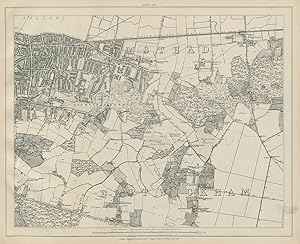
Stanford's Library map of London and its suburbs - Sheet 1 & Sheet 1a
Data di pubblicazione: 1895
Da: Antiqua Print Gallery, London, Regno Unito
Valutazione del venditore 3 su 5 stelle
Mappa
EUR 253,61
Convertire valutaEUR 35,17 per la spedizione da Regno Unito a ItaliaQuantit�: 1 disponibili
Aggiungi al carrelloCondizione: Good. Stanford Library map of London Sheet 1/a Hampstead Golder's Grn Cricklewood 1895. Antique street map of part of London; Edward Stanford (These maps are undated. From the content we date them at circa 1895, although the western extensions of maps 1, 5, 9, 13, 17 & 21 appear to be earlier. Key dating references include the presence of Tower Bridge (opened 1894) and Rosebery Avenue (1892) and the absence of the Blackwall Tunnel (opened 1897) and the Boundary Estate (1896)). 36.0 x 63.0cm, 14.25 x 24.75 inches; this is a folding map. Condition: Good. Minor blemishes; Light spotting; Light crease. Repaired marginal tear. Please contact us if you would like to arrange to view this map. There is nothing printed on the reverse side, which is plain. Sheet 1 Hampstead, Golder's Green, Cricklewood, Childs Hill, Brent Cross & Sheet 1a Neasden, Welsh Harp Reservoir, Dollis Hill, Gladstone Park.
-
Stanford's Library map of London and its suburbs - Sheet 9 & Sheet 9a
Data di pubblicazione: 1895
Da: Antiqua Print Gallery, London, Regno Unito
Valutazione del venditore 3 su 5 stelle
Mappa
EUR 253,61
Convertire valutaEUR 35,17 per la spedizione da Regno Unito a ItaliaQuantit�: 1 disponibili
Aggiungi al carrelloCondizione: Fair. Stanford Library map of London Sheet 9/9a Kensington Notting Hill Bayswater 1895. Antique street map of part of London; Edward Stanford (These maps are undated. From the content we date them at circa 1895, although the western extensions of maps 1, 5, 9, 13, 17 & 21 appear to be earlier. Key dating references include the presence of Tower Bridge (opened 1894) and Rosebery Avenue (1892) and the absence of the Blackwall Tunnel (opened 1897) and the Boundary Estate (1896)). 35.5 x 63.0cm, 14 x 24.75 inches; this is a folding map. Condition: Fair: There is a neatly repaired tear extending from the margin close to Olympia to just south of Shepherds Bush station. Two small marks in red paint or ink. Light crease. Please contact us if you would like to arrange to view this map. There is nothing printed on the reverse side, which is plain. Sheet 9 Kensington Park, Holland Park, Bayswater, Notting Hill, Paddington, Kensington, Shepherd's Bush, Hammersmith, White City & Sheet 9a East Acton, Wormwood Scrubs, Chiswick, Stamford Brook.
-
1862 STANFORD'S LIBRARY MAP OF LONDON and SUBURBS East Docklands Islington
Da: Antique Paper Company, ASHFORD, KENT, Regno Unito
Valutazione del venditore 2 su 5 stelle

Mappa
EUR 1.147,28
Convertire valutaEUR 7,03 per la spedizione da Regno Unito a ItaliaQuantit�: 1 disponibili
Aggiungi al carrello1862 STANFORDS LIBRARY MAP OF LONDON AND ITS SUBURBSAn exceptional example of the very large scale folding map of the regions of East South East London stretching from Stoke Newington to Walthamstow at the top and from Brixton to Blackheath at the bottom, further incorporating the likes of Islington, Farringdon, Smithfield, Borough, Walworth, Tower Hamlets, London Fields, Whitechapel, Surrey Docks, Deptford, Stratford, Bow, Docklands, Isle of Dogs, Greenwich etc. Incredible detail throughout right down to showing the position of Trees in the Parks individual houses and buildings.This example incorporates Sheets 3,4 7,8,11,12 15 16, dissected into 36 sections and laid to linen. Overall size approx 126cm x 84cm (49.6in x33in) once opened out. Condition is outstanding.Antique Paper Company are a long established family business selling original antique prints, maps engravings as well as many other paper antiques such as original vintage Decorative Posters, Ephemera, Stamps Postal History, Manuscripts, Antiquarian Books much more. We are always looking to buy and have up to andpound;500,000 in immediate funds available. We are looking for exceptional single items, better collections, original archives, Atlases, Libraries, accumulations etc and have previously purchased from Major Institutions, Libraries, Collectors, Solicitors many other sources. We are happy to travel almost anywhere in the world for the right opportunities. So please do get in touch if you are considering selling your Antique Paper collectables.