Importo totale (1 articolo articoli):
Destinazione ordine:

stanfords map sea azov compiled di stanford edward (1 risultati)
Feedback
Hai cercato:
Autore:
stanford edward
,
Titolo:
stanfords map sea azov compiled
Modificare la ricerca
Vai alla pagina principale dei risultati di ricerca
Filtri di ricerca
Tipo di articolo
- Tutti i tipi di prodotto
- Libri (Nessun altro risultato corrispondente a questo perfezionamento)
- Riviste e Giornali (Nessun altro risultato corrispondente a questo perfezionamento)
- Fumetti (Nessun altro risultato corrispondente a questo perfezionamento)
- Spartiti (Nessun altro risultato corrispondente a questo perfezionamento)
- Arte, Stampe e Poster (Nessun altro risultato corrispondente a questo perfezionamento)
- Fotografie (Nessun altro risultato corrispondente a questo perfezionamento)
- Mappe (1)
- Manoscritti e Collezionismo cartaceo (Nessun altro risultato corrispondente a questo perfezionamento)
Condizioni
- Tutte
- Nuovi (Nessun altro risultato corrispondente a questo perfezionamento)
- Antichi o usati (1)
Legatura
- Tutte
- Rilegato (Nessun altro risultato corrispondente a questo perfezionamento)
- Brossura (Nessun altro risultato corrispondente a questo perfezionamento)
Ulteriori caratteristiche
- Prima ed. (Nessun altro risultato corrispondente a questo perfezionamento)
- Copia autograf. (Nessun altro risultato corrispondente a questo perfezionamento)
- Sovracoperta (Nessun altro risultato corrispondente a questo perfezionamento)
- Con foto (1)
- Non Print on Demand (1)
Lingua (1)
Prezzo
- Qualsiasi prezzo
- Inferiore a EUR 20 (Nessun altro risultato corrispondente a questo perfezionamento)
- EUR 20 a EUR 45 (Nessun altro risultato corrispondente a questo perfezionamento)
- Superiore a EUR 45
Spedizione gratuita
- Spedizione gratuita in Italia (Nessun altro risultato corrispondente a questo perfezionamento)
Paese del venditore
Valutazione venditore
-
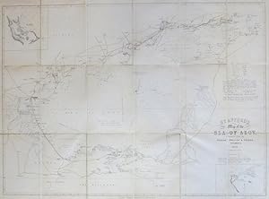
Stanford's Map of the Sea of Azov, Compiled from the Russian, English & French Documents
Editore: London: Edward Stanford, 1855
Da: Bow Windows Bookshop (ABA, ILAB), Lewes, Regno Unito
Membro dell'associazione: ABA ILAB PBFA
Valutazione del venditore 5 su 5 stelle

Mappa
EUR 240,51
Convertire valutaEUR 15,18 per la spedizione da Regno Unito a ItaliaQuantit�: 1 disponibili
Aggiungi al carrelloMap dimensions 52 x 72 cm, overall 56 x 76 cm. Folding Crimean War map of the sea and the surrounding lands, minimally coloured in outline, inset plans of the Black Sea ports of Kaffa (Feodosia) and Anapa, dissected into 18 sections and mounted on linen, folds between brown cloth boards with a blue printed label to the upper cover, marbled paper to the folded end section and the inner cover. Very good condition.