We can accept payment by Mastercard, Visa and Sterling cheques, as well as by bank transfer. Please make cheques payable to Bow Windows Bookshop Ltd. All books must be prepaid before sending, unless you are already known to us. All books are returnable for a full refund if found not to be as described. Postage will be charged at cost and at buyer's request by air or surface mail, and will automatically include full insurance cover.
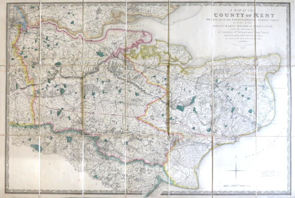
Bow Windows Bookshop Ltd., registered in England and Wales, comp...
Se sei un consumatore puoi recedere dal contratto in conformit� con quanto segue. Per Consumatore si intende qualsiasi persona fisica che agisce per scopi estranei alla propria attivit� commerciale, imprenditoriale, artigianale o professionale.
Informazioni sul diritto di recesso
Diritto legale di recesso
Hai il diritto di recedere dal presente contratto entro 14 giorni senza fornire alcuna motivazione.
Il periodo di recesso scade dopo 14 giorni dal giorno in cui tu o una terza parte, diversa dal vettore e da te indicata, acquisisce il possesso fisico dell'ultimo bene o dell'ultimo lotto o pezzo.
Per esercitare il diritto di recesso, compila e invia elettronicamente una dichiarazione esplicita sul nostro sito Web, alla voce “I miei acquisti” nella sezione “Mio account”. Ti comunicheremo senza indugio una conferma di ricezione di tale recesso su un supporto durevole (ad es. via e-mail).
Per rispettare il termine di recesso, � sufficiente inviare la comunicazione relativa all'esercizio del diritto di recesso prima della scadenza del periodo di recesso stesso.
Effetti del recesso
In caso di recesso dal presente contratto, ti rimborseremo tutti i pagamenti ricevuti, compresi i costi di spedizione (ad eccezione dei costi supplementari derivanti dalla tua eventuale scelta di un tipo di spedizione diverso dal tipo meno costoso di consegna standard da noi offerto).
Potremo effettuare una detrazione dal rimborso per la perdita di valore dei beni forniti, qualora tale perdita sia il risultato di una manipolazione non necessaria da parte tua.
Eseguiremo il rimborso senza indebito ritardo e non oltre 14 giorni dal giorno in cui saremo informati della tua decisione di recedere dal presente contratto.
Il rimborso sar� effettuato utilizzando lo stesso mezzo di pagamento da te usato per la transazione iniziale, salvo che tu non abbia espressamente concordato altrimenti; in ogni caso, non dovrai sostenere alcun costo quale conseguenza di tale rimborso.
Possiamo trattenere il rimborso finch� non avremo ricevuto i beni oppure finch� non avrai fornito la prova di averli rispediti, a seconda di quale condizione si verifichi per prima.
Dovrai rispedire i beni o consegnarli a Bow Windows Bookshop (ABA, ILAB), Lewes, United Kingdom, +44 (0)1273 480 780, senza indebito ritardo e, in ogni caso, entro 14 giorni dal giorno in cui ci hai comunicato la tua volont� di recedere dal presente contratto. Il termine � rispettato se rispedisci i beni prima della scadenza del periodo di 14 giorni. I costi diretti della restituzione dei beni saranno a tuo carico. Sei responsabile solo della diminuzione del valore dei beni risultante da una manipolazione diversa da quella necessaria per stabilire la natura, le caratteristiche e il funzionamento dei beni stessi.
Eccezioni al diritto di recesso
Il diritto di recesso non si applica a:
- La fornitura di giornali, periodici o riviste ad eccezione dei contratti di abbonamento; e
- La fornitura di contenuto digitale non fornito su un supporto materiale (ad es. su un CD o DVD), se al momento dell'invio dell'ordine hai accettato l'inizio dell'esecuzione e hai riconosciuto che non avresti potuto recedere una volta iniziata l'esecuzione.
