Importo totale (1 articolo articoli):
Destinazione ordine:

mudge colonel (24 risultati)
Vai alla pagina principale dei risultati di ricerca
Filtri di ricerca
Tipo di articolo
- Tutti i tipi di prodotto
- Libri (17)
- Riviste e Giornali (Nessun altro risultato corrispondente a questo perfezionamento)
- Fumetti (Nessun altro risultato corrispondente a questo perfezionamento)
- Spartiti (Nessun altro risultato corrispondente a questo perfezionamento)
- Arte, Stampe e Poster (Nessun altro risultato corrispondente a questo perfezionamento)
- Fotografie (Nessun altro risultato corrispondente a questo perfezionamento)
- Mappe (7)
- Manoscritti e Collezionismo cartaceo (Nessun altro risultato corrispondente a questo perfezionamento)
Condizioni Maggiori informazioni
- Nuovo (15)
- Come nuovo, Ottimo o Quasi ottimo (2)
- Molto buono o Buono (3)
- Discreto o Mediocre (Nessun altro risultato corrispondente a questo perfezionamento)
- Come descritto (4)
Legatura
Ulteriori caratteristiche
- Prima ed. (Nessun altro risultato corrispondente a questo perfezionamento)
- Copia autograf. (Nessun altro risultato corrispondente a questo perfezionamento)
- Sovracoperta (Nessun altro risultato corrispondente a questo perfezionamento)
- Con foto (12)
- Non Print on Demand (17)
Lingua (2)
Prezzo
- Qualsiasi prezzo
- Inferiore a EUR 20 (Nessun altro risultato corrispondente a questo perfezionamento)
- EUR 20 a EUR 45
- Superiore a EUR 45
Spedizione gratuita
Paese del venditore
Valutazione venditore
-

An Account Of The Trigonometrical Survey; Carried On By Order Of The Master General Of His Majesty'S Ordnance, In This Years 1800 To 1809 (Volume Iii)
Da: GreatBookPrices, Columbia, MD, U.S.A.
Valutazione del venditore 5 su 5 stelle

EUR 37,12
Spedizione EUR 2,30
Spedito in U.S.A.Quantit�: Pi� di 20 disponibili
Aggiungi al carrelloCondizione: New.
-
An Account Of The Trigonometrical Survey; Carried On By Order Of The Master General Of His Majesty'S Ordnance, In This Years 1800 To 1809 (Volume Iii)
Da: California Books, Miami, FL, U.S.A.
Valutazione del venditore 4 su 5 stelle

EUR 39,49
Spedizione gratuita
Spedito in U.S.A.Quantit�: Pi� di 20 disponibili
Aggiungi al carrelloCondizione: New.
-
An Account Of The Trigonometrical Survey; Carried On By Order Of The Master General Of His Majesty'S Ordnance, In This Years 1800 To 1809 (Volume Iii)
Da: GreatBookPrices, Columbia, MD, U.S.A.
Valutazione del venditore 5 su 5 stelle
EUR 39,95
Spedizione EUR 2,30
Spedito in U.S.A.Quantit�: Pi� di 20 disponibili
Aggiungi al carrelloCondizione: As New. Unread book in perfect condition.
-
An Account Of The Trigonometrical Survey; Carried On By Order Of The Master General Of His Majesty'S Ordnance, In This Years 1800 To 1809 (Volume Iii)
Da: Books Puddle, New York, NY, U.S.A.
Valutazione del venditore 4 su 5 stelle
Condizione: New.
-

An Account Of The Trigonometrical Survey; Carried On By Order Of The Master General Of His Majesty'S Ordnance, In This Years 1800 To 1809 (Volume Iii)
Da: Rarewaves.com USA, London, LONDO, Regno Unito
Valutazione del venditore 5 su 5 stelle
EUR 48,30
Spedizione gratuita
Spedito da Regno Unito a U.S.A.Quantit�: Pi� di 20 disponibili
Aggiungi al carrelloPaperback. Condizione: New.
-
An Account Of The Trigonometrical Survey; Carried On By Order Of The Master General Of His Majesty'S Ordnance, In This Years 1800 To 1809 (Volume Iii)
Da: Chiron Media, Wallingford, Regno Unito
Valutazione del venditore 5 su 5 stelle
EUR 34,49
Spedizione EUR 17,86
Spedito da Regno Unito a U.S.A.Quantit�: 10 disponibili
Aggiungi al carrelloPF. Condizione: New.
-
An Account Of The Trigonometrical Survey; Carried On By Order Of The Master General Of His Majesty'S Ordnance, In This Years 1800 To 1809 (Volume Iii)
Da: Ria Christie Collections, Uxbridge, Regno Unito
Valutazione del venditore 5 su 5 stelle
EUR 38,19
Spedizione EUR 13,81
Spedito da Regno Unito a U.S.A.Quantit�: Pi� di 20 disponibili
Aggiungi al carrelloCondizione: New. In.
-
An Account Of The Trigonometrical Survey; Carried On By Order Of The Master General Of His Majesty'S Ordnance, In This Years 1800 To 1809 (Volume Iii)
Da: GreatBookPricesUK, Woodford Green, Regno Unito
Valutazione del venditore 5 su 5 stelle
EUR 36,76
Spedizione EUR 17,30
Spedito da Regno Unito a U.S.A.Quantit�: Pi� di 20 disponibili
Aggiungi al carrelloCondizione: New.
-
An Account Of The Trigonometrical Survey; Carried On By Order Of The Master General Of His Majesty'S Ordnance, In This Years 1800 To 1809 (Volume Iii)
Da: GreatBookPricesUK, Woodford Green, Regno Unito
Valutazione del venditore 5 su 5 stelle
EUR 41,21
Spedizione EUR 17,30
Spedito da Regno Unito a U.S.A.Quantit�: Pi� di 20 disponibili
Aggiungi al carrelloCondizione: As New. Unread book in perfect condition.
-

An Account Of The Trigonometrical Survey; Carried On By Order Of The Master General Of His Majesty'S Ordnance, In This Years 1800 To 1809 (Volume Iii)
Da: Rarewaves.com UK, London, Regno Unito
Valutazione del venditore 5 su 5 stelle
EUR 44,40
Spedizione EUR 74,95
Spedito da Regno Unito a U.S.A.Quantit�: Pi� di 20 disponibili
Aggiungi al carrelloPaperback. Condizione: New.
-
EUR 148,46
Spedizione EUR 28,83
Spedito da Regno Unito a U.S.A.Quantit�: 1 disponibili
Aggiungi al carrelloHardcover. Condizione: Good. Coloured travelling map 98 x 68cm dissected into 36 sections and backed on to linen, folding down into its original dark green cloth slipcase 12 x 18cm with Wyld's label to the front (James Wyld Cartographer to Her Majesty, 452 Strand.). Sheet No. VI "Published 1st Jan by Col Mudge, Tower. Electrotyped in 1865. Price 2/6. Engraved at the Drawing Room in the Tower under the Direction of Col. Mudge by Benjn. Baker and Assistants. The writing by Ebenr. Bourne". Scale: 1 inch to the mile (a second scale in Furlongs). Coverage: Penge Common (NW) - Southfleet (N) - Chitney Marsh (NE) - Lenham (E) - High Halden (SE) - Eridge New and Old Park (S) - Godstone (W). Paper very good, lightly dusted and marked. Linen tanned and stained. Slipcase good only, marked with wear to extremities and darkening and wear to label.
-
Map of Surrey [folded]
Editore: Colonel Mudge / Sold by Letts, Son and Co, 8 Royal Exchange, E.C. Map, Chart & Globe Sellers. Agents by Appointment for the Sale of Ordnance Maps., 1816
Da: Gwyn Tudur Davies, Aberystwyth, Regno Unito
Valutazione del venditore 5 su 5 stelle
Mappa
EUR 112,83
Spedizione EUR 14,41
Spedito da Regno Unito a U.S.A.Quantit�: 1 disponibili
Aggiungi al carrelloSoft cover. Condizione: Good. No Jacket. 1 folded linen backed map of Surrey. Engraved at the Drawing Room in the Tower under the Direction of Colonel Mudge by Benj. Baker & Assistants, writing by Eben. Bourne. Published on the 1st May, 1816 by Colonel Mudge. Scale in furlongs and miles. Some foxing and old water-stain on verso of map, also some tanning along fold marks of map o/w a very clean copy in good condition. e1041 / m11777.
-
Ordnance Survey Folding Map of West Surrey, Sheet No. VIII.
Editore: Published by James Wyld and the Ordnance Survey, The TowerLondon, 1869
Da: Keoghs Books, Skipton, Regno Unito
Membro dell'associazione: PBFA
Valutazione del venditore 5 su 5 stelle
Mappa
EUR 112,83
Spedizione EUR 32,29
Spedito da Regno Unito a U.S.A.Quantit�: 1 disponibili
Aggiungi al carrello, folding map with 36 sections, linen-backed, 100 x 68 cm opened, hand-coloured borders, railway lines, and parks, covers Wokingham at top left corner, Croydon top right, Woolmer Forest bottom left, and Crawley bottom right, printed from an electrotype taken in 1869, first published 1816 by the Ordnance Survey,1 1/4 inches to a mile Reprint , a few small spots otherwise map clean and complete, in very good condition, case a little rubbed at corners, very good condition , dark blue cloth case with original printed paper title label to side 17 x 12 cm Hardback ISBN:
-

Ordnance Survey Map 8: Surrey, 1816.
Editore: James Wyld, London 1876, 1876
Da: ROBIN SUMMERS BOOKS LTD, Aldeburgh, Regno Unito
Valutazione del venditore 5 su 5 stelle
Mappa
EUR 118,76
Spedizione EUR 33,44
Spedito da Regno Unito a U.S.A.Quantit�: 1 disponibili
Aggiungi al carrelloCondizione: Very Good. Paperback. Large folding, linen-backed map, 40 x 25 inches, scale 1 inch to 1 mile. One small mark, otherwise clean, very good indeed. Original cloth-backed case slightly worn and faded with label over original printed label. 1876 reproduction from the 1816 original.
-
Ordnance Survey Map of England and Wales, Sheet No. 34 One inch to One Mile [Wiltshire, Wales, Gloucestershire etc]
Editore: Published by Ordnance Survey, London, 1875
Da: Keoghs Books, Skipton, Regno Unito
Membro dell'associazione: PBFA
Valutazione del venditore 5 su 5 stelle
Mappa
EUR 178,15
Spedizione EUR 32,29
Spedito da Regno Unito a U.S.A.Quantit�: 1 disponibili
Aggiungi al carrello, large folding map measuring 125 x 162 cm, scale of 1 inch to 1 statue mile, engraved at the drawing room in the tower under the direction of Col Mudge by Benj. Baker & Assistants - the writing by Eben Bourne, originally published 11th Aug 1817 by Col Mudge, Tower. This version printed from an electrotype taken in 1875 Later edition , Patches of light brown staining to map, no tears, map in very good condition , with slip case in just good condition , Folding cloth backed map 26 x 17 cm Hardback ISBN:
-
An Account Of The Trigonometrical Survey; Carried On By Order Of The Master General Of His Majesty'S Ordnance, In This Years 1800 To 1809 (Volume Iii)
Da: Majestic Books, Hounslow, Regno Unito
Valutazione del venditore 4 su 5 stelle
EUR 33,07
Spedizione EUR 7,49
Spedito da Regno Unito a U.S.A.Quantit�: 4 disponibili
Aggiungi al carrelloCondizione: New. Print on Demand.
-
An Account Of The Trigonometrical Survey; Carried On By Order Of The Master General Of His Majesty'S Ordnance, In This Years 1800 To 1809 (Volume Iii)
Da: PBShop.store US, Wood Dale, IL, U.S.A.
Valutazione del venditore 5 su 5 stelle
EUR 42,99
Spedizione gratuita
Spedito in U.S.A.Quantit�: Pi� di 20 disponibili
Aggiungi al carrelloPAP. Condizione: New. New Book. Shipped from UK. THIS BOOK IS PRINTED ON DEMAND. Established seller since 2000.
-
An Account Of The Trigonometrical Survey; Carried On By Order Of The Master General Of His Majesty'S Ordnance, In This Years 1800 To 1809 (Volume Iii)
Da: PBShop.store UK, Fairford, GLOS, Regno Unito
Valutazione del venditore 5 su 5 stelle
EUR 36,77
Spedizione EUR 7,79
Spedito da Regno Unito a U.S.A.Quantit�: Pi� di 20 disponibili
Aggiungi al carrelloPAP. Condizione: New. New Book. Delivered from our UK warehouse in 4 to 14 business days. THIS BOOK IS PRINTED ON DEMAND. Established seller since 2000.
-
An Account Of The Trigonometrical Survey; Carried On By Order Of The Master General Of His Majesty'S Ordnance, In This Years 1800 To 1809 (Volume Iii)
Da: Biblios, Frankfurt am main, HESSE, Germania
Valutazione del venditore 4 su 5 stelle
EUR 34,62
Spedizione EUR 9,95
Spedito da Germania a U.S.A.Quantit�: 4 disponibili
Aggiungi al carrelloCondizione: New. PRINT ON DEMAND.
-
Ordnance Survey Map Sheet 22, South Devon
Editore: Published by The Ordnance Survey, London, 1874
Da: Keoghs Books, Skipton, Regno Unito
Membro dell'associazione: PBFA
Valutazione del venditore 5 su 5 stelle
Mappa
EUR 89,07
Spedizione EUR 32,29
Spedito da Regno Unito a U.S.A.Quantit�: 1 disponibili
Aggiungi al carrello, linen backed black and white ordnance survery map, one inch to a mile, South Coast of Devon including Torbay, Exmouth, Sidmout, Lyme Regis and Teignmouth Reprint , slight foxing to linen backing, no slipcase, a few marks, good condition , linen backed map , 66 cm x 98 cm (open), 17 cm x 11 cm (folded) Map ISBN:
-
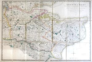
A Map of the County of Kent Drawn from the Topographical Survey Taken, by Order of the Honourable Board of Ordnance, . Reduced from the Large Map in Four Sheets by a Scale of One Inch to Two Statute Miles
Editore: London: Jas. Wyld, 1841
Da: Bow Windows Bookshop (ABA, ILAB), Lewes, Regno Unito
Membro dell'associazione: ABA ILAB PBFA
Valutazione del venditore 5 su 5 stelle
Mappa
EUR 350,36
Spedizione EUR 25,37
Spedito da Regno Unito a U.S.A.Quantit�: 1 disponibili
Aggiungi al carrelloMap dimensions 59.5 x 89 cm, overall 63.5 x 94.5 cm. Finely engraved folding map of the county, dissected into twenty-four sections and mounted on linen, green silk trim to the edges, marbled paper to the folded end sections, folds into original green embossed cloth slipcase with Wyld's printed label to upper board and brief title label to one spine. Some mild wear to the corners of the case, a lovely example overall. Kent was the first of the Ordnance Survey maps to be published, appearing in 1801. This version, reduced in format and scale, was first published by Faden in 1807 and then by his successors, the Wylds, at intervals through to the mid-19th century.
-

EUR 47,84
Spedizione EUR 48,99
Spedito da Germania a U.S.A.Quantit�: Pi� di 20 disponibili
Aggiungi al carrelloCondizione: New. Dieser Artikel ist ein Print on Demand Artikel und wird nach Ihrer Bestellung fuer Sie gedruckt. KlappentextrnrnThis book has been considered by academicians and scholars of great significance and value to literature. This forms a part of the knowledge base for future generations. So that the book is never forgotten we have represented this.
-

EUR 49,70
Spedizione EUR 70,00
Spedito da Germania a U.S.A.Quantit�: 5 disponibili
Aggiungi al carrelloTaschenbuch. Condizione: Neu. An Account Of The Trigonometrical Survey; Carried On By Order Of The Master General Of His Majesty'S Ordnance, In This Years 1800 To 1809 (Volume Iii) | Lieutenant-Colonel William Mudge | Taschenbuch | Kartoniert / Broschiert | Englisch | 2020 | Alpha Editions | EAN 9789354309809 | Verantwortliche Person f�r die EU: Libri GmbH, Europaallee 1, 36244 Bad Hersfeld, gpsr[at]libri[dot]de | Anbieter: preigu Print on Demand.
-

EUR 59,71
Spedizione EUR 65,04
Spedito da Germania a U.S.A.Quantit�: 1 disponibili
Aggiungi al carrelloTaschenbuch. Condizione: Neu. nach der Bestellung gedruckt Neuware - Printed after ordering - Step into the world of Georgian Britain, where scientific ambition and national vision converged to reshape a nation's understanding of its own landscape. An Account Of The Trigonometrical Survey; Carried On By Order Of The Master General Of His Majesty'S Ordnance, In This Years 1800 To 1809 (Volume III) stands as a monumental historical surveying report-painstaking, precise, and deeply evocative of its era. Within these pages, Lieutenant-Colonel William Mudge documents the pioneering trigonometrical triangulation methods and baseline measurement calculations that laid the groundwork for the Great Britain Ordnance Survey, transforming the art of geodesy and cartography into a rigorous science.Every detail in this complete Volume III reprint reveals the challenges and triumphs of early modern scientific instruments, topographic mapping techniques, and the relentless pursuit of accuracy. For researchers, this is an indispensable cartography monograph and surveying history reference; for collectors and the curious, it is a window into the intellectual spirit and government ordnance publication protocols of the early 1800s. Mudge's account does more than recount technical achievements-it captures a moment when measurement became a tool of progress, and the British landscape unfolded in new clarity.Republished by Alpha Editions in a careful modern edition, this volume preserves the spirit of the original while making it effortless to enjoy today-a heritage title prepared for readers and collectors alike. Whether you are delving into the roots of geodesy, seeking a cartography research source, or adding a rare piece of surveying history to your collection, this work endures as both a cultural treasure and a testament to the enduring power of scientific curiosity.

![Immagine del venditore per Map of Surrey [folded] venduto da Gwyn Tudur Davies](https://pictures.abebooks.com/inventory/md/md31065775291.jpg)

![Immagine del venditore per Ordnance Survey Map of England and Wales, Sheet No. 34 One inch to One Mile [Wiltshire, Wales, Gloucestershire etc] venduto da Keoghs Books](https://pictures.abebooks.com/inventory/md/md30998042851.jpg)