Antoine louis printer (58 risultati)

Original Map - "Tableau de la Dispersion des Enfants de Noe, ou Creation des Peuples dans le 2e. age du Monde [Table of the Dispersion of the Children of Noah, or Creation of Peoples in the 2nd age of the world]; Pl. 2"; From "Atlas geographique dresse pour l'histoire universelle de l'eglise catholique de l'abbe Rohrbacher" ("Geographical Atlas, Compiled for, the Universal History of the Catholic Church of Abbot Rohrbacher")
Dufour, A. H. (Auguste Henri); Rohrbacher, Rene Francois; Antoine, Louis (Printer); Lahanier-Lacouchy
Lingua: Francese
Editore: Gaume Freres et J. Duprey, Editeurs, Paris, France 1861
- Mappa
Da: Barry Cassidy Rare Books, Sacramento, U.S.A.Barry Cassidy Rare Books
Contatta il venditoreVenditore con 5 stelleCondizione: Usato - Molto buono
EUR 89,30
EUR 5,20 spedizioneSpedito in U.S.A.Quantità: 1 disponibili
Aggiungi al carrelloNo Binding. Condizione: Collectible-Very Good. Text is in French. Original publisher's hand-colored map showing the dispersion of the children of Noah after the Great Flood. Composition is roughly centered around the present-day Sinai Peninsula. The map also includes parts of Africa, Europe, Eurasia, India, and Asia. Map with ma…rgins measures 21 1/2" x 16 1/2." Actual map area measures 18" x 13." The vertical center fold line is original as this map came from an atlas. Map is very clean and intact except for some foxing and age toning on front and back and minuscule wear to edges and corners. A Very Good copy. Watercolors appear in pink, blue, and orange exclusively as lines representing the dispersion routes taken by Noah's three sons, Shem (Fr., "Sem"), Ham (Fr., "Cham"), and Japeth (Fr., "Japet"), and their grandsons. A legend in the lower-left corner defines which colors and correspond to which of Noah's sons. An oval in light blue watercolor shows the origin of the dispersion. Major cities and natural features such as mountains, seas, and rivers are included. Title printed below the map. Lines of latitude and longitude and neatline also included. The following is printed beneath the map below the neatline: "Impie. ['Imprimerie'] de Louis Antoine, 1, rue de Cluny, Paris" and "La Lettre par Lahanier-Lacouchy." This map is Plate 2 from an atlas that accompanied "L'Historie universelle de l'eglise catholique" ("Universal History of the Catholic Church"), a notable work by Abbot Rohrbacher. Rene Francois Rohrbacher (1789-1856) was a French priest, ecclesiastical historian, and politician. The main author of this atlas is Auguste Henri Dufour (1795-1865), a French geographer.
Original Map - "Empires Assyrio-Babyloniens et Medo-Perses, de 721 a 500 avant J.C. [Assyro-Babylonian and Medo-Persian Empires, from 721 to 500 BC]; Pl. 5"; From "Atlas geographique dresse pour l'histoire universelle de l'eglise catholique de l'abbe Rohrbacher" ("Geographical Atlas, Compiled for, the Universal History of the Catholic Church of Abbot Rohrbacher")
Dufour, A. H. (Auguste Henri); Rohrbacher, Rene Francois; Raynaud; Antoine, Louis (Printer); Lahanier-Lacouchy
Lingua: Francese
Editore: Gaume Freres et J. Duprey, Editeurs, Paris, France 1861
- Mappa
Da: Barry Cassidy Rare Books, Sacramento, U.S.A.Barry Cassidy Rare Books
Contatta il venditoreVenditore con 5 stelleCondizione: Usato - Molto buono
EUR 89,30
EUR 5,20 spedizioneSpedito in U.S.A.Quantità: 1 disponibili
Aggiungi al carrelloNo Binding. Condizione: Collectible-Very Good. Text is in French. Original publisher's hand-colored map showing the Assyro-Babylonian and Medo-Persian (Achaemenid) Empires from the years 721 to 500 BCE. Composition is roughly centered around the empires, which were located roughly in what is present-day Iran and Iraq. The Persia…n Gulf and Caspian Sea are pictured at the top and bottom of the map. Surrounding areas also shown including the Arabian Desert to the west and "Parthes" and "Carmanie" to the east. Map with margins measures 21 1/2" x 16 1/2." Actual map area measures 18" x 13." The vertical center fold line is original as this map came from an atlas. Map is very clean and intact except for some foxing and age toning on front and back and minuscule wear to edges and corners. A Very Good copy. The map features beautiful pink and green watercolors within the Assyro-Babylonian and Medo-Persian Empires, respectively, as well as additional watercolored lines in green, blue, orange, and pink which demarcate regional borders or routes relating to historical events. Major cities and natural features such as mountains, seas, and rivers are included. Scales of distance in the lower-right corner below the title. Lines of latitude and longitude and neatline also included. The following is printed beneath the map below the neatline: "Le Trait par Raynaud," "Impie. ['Imprimerie'] de Louis Antoine, 1, rue de Cluny, Paris," and "La Lettre par Lahanier-Lacouchy." This map is Plate 5 from an atlas that accompanied "L'Historie universelle de l'eglise catholique" ("Universal History of the Catholic Church"), a notable work by Abbot Rohrbacher. Rene Francois Rohrbacher (1789-1856) was a French priest, ecclesiastical historian, and politician. The main author of this atlas is Auguste Henri Dufour (1795-1865), a French geographer.
Original Map - "Tribus d'Israel, de 1424 a 1055 avant J.C. [Tribes of Israel, from 1424 to 1055 BC]; Pl. 4"; From "Atlas geographique dresse pour l'histoire universelle de l'eglise catholique de l'abbe Rohrbacher" ("Geographical Atlas, Compiled for, the Universal History of the Catholic Church of Abbot Rohrbacher")
Dufour, A. H. (Auguste Henri); Rohrbacher, Rene Francois; Raynaud; Antoine, Louis (Printer); Lahanier et Lacouchy
Lingua: Francese
Editore: Gaume Freres et J. Duprey, Editeurs, Paris, France 1861
- Mappa
Da: Barry Cassidy Rare Books, Sacramento, U.S.A.Barry Cassidy Rare Books
Contatta il venditoreVenditore con 5 stelleCondizione: Usato - Molto buono
EUR 89,30
EUR 5,20 spedizioneSpedito in U.S.A.Quantità: 1 disponibili
Aggiungi al carrelloNo Binding. Condizione: Collectible-Very Good. Text is in French. Original publisher's hand-colored map and two insets maps showing Israel in the years 1424 to 1055 BCE with many details and additions connecting the maps to events in the Old Testament of the Bible. The two inset maps are titled, "Royaume des Israelites sous Davi…d et Salomon, de 1055 a 975 avant J.C." ("Kingdom of the Israelites under David and Solomon, 1055 to 975 BC") and "Royaumes de Juda et d'Israel, de 975 a 721 avant J.C." ("Kingdoms of Judah and Israel, from 975 to 721 BC). Map with margins measures 21 1/2" x 16 1/2." Actual map area measures 18" x 13." Main map measures 10 1/2" x 13." Each of the inset maps measures about 7" x 7." The vertical center fold line is original as this map came from an atlas. Map is very clean and intact except for some foxing and age toning on front and back and minuscule wear to edges and corners. A Very Good copy. The maps features beautiful blue, pink, and light gray watercolors within country or regional borders. Additional watercolors in green, dark blue, purple, and orange accent text, demarcate boundaries, or highlight cities. There is one legend on the main map (showing the Twelve Tribes of Israel) that shows the symbols for cities of refuge and Levitical cities (cities reserved for the Tribe of Levi). Other major cities and natural features such as mountains, seas, and rivers are included. Each of the maps includes a title and a scale or scales of distance. The legend appears below the scales of distance on the main map. Lines of latitude and longitude and neatline also included. The following is printed beneath the map below the neatline: "Le Trait par Raynaud," "Impie. ['Imprimerie'] de Louis Antoine, 1, rue de Cluny, Paris," and "Ecrit par Lahanier et Lacouchy." This map is Plate 4 from an atlas that accompanied "L'Historie universelle de l'eglise catholique" ("Universal History of the Catholic Church"), a notable work by Abbot Rohrbacher. Rene Francois Rohrbacher (1789-1856) was a French priest, ecclesiastical historian, and politician. The main author of this atlas is Auguste Henri Dufour (1795-1865), a French geographer.
Original Map - "Empire Romain (Partie Orientale), de l'an 100 a 410 J.C. [Roman Empire (Eastern Part), from the year 100 to 410 AD]; Pl. 10"; From "Atlas geographique dresse pour l'histoire universelle de l'eglise catholique de l'abbe Rohrbacher" ("Geographical Atlas, Compiled for, the Universal History of the Catholic Church of Abbot Rohrbacher")
Dufour, A. H. (Auguste Henri); Rohrbacher, Rene Francois; Raynaud; Antoine, Louis (Printer); Lahanier, Lacouchy & Cie.
Lingua: Francese
Editore: Gaume Freres et J. Duprey, Editeurs, Paris, France 1861
- Mappa
Da: Barry Cassidy Rare Books, Sacramento, U.S.A.Barry Cassidy Rare Books
Contatta il venditoreVenditore con 5 stelleCondizione: Usato - Molto buono
EUR 89,30
EUR 5,20 spedizioneSpedito in U.S.A.Quantità: 1 disponibili
Aggiungi al carrelloNo Binding. Condizione: Collectible-Very Good. Text is in French. Original publisher's hand-colored map showing the eastern part of the Roman Empire between the years 100 and 410. Year 410 marks the Sack of Rome, when the Visigoths took over the Roman Empire's famed "eternal city." The Sack of Rome is considered a pivotal landma…rk in the fall of the Roman Empire. A legend corresponds to lines in orange and dark green watercolors, which show the expedition of Emperor Julian (sometimes referred to as Julian the Apostate) and the invasion of the Visigoths. Map with margins measures 16 1/2" x 21 1/2." Actual map area measures 13" x 18." The horizontal center fold line is original as this map came from an atlas. Map is very clean and intact except for some foxing and age toning on front and back and minuscule wear to edges and corners. A Very Good copy. This map shows the eastern part of the Roman Empire and surrounding areas. Some of the depicted regions and geographical features include the Mediterranean Sea, the Black Sea, Palestine (Judea), the Sinai Peninsula, Egypt, present-day Libya, the Aegean region, present-day Turkey, Sarmatia, and Scythia. The map features beautiful blue, yellow, green, and pink watercolors within country or regional borders. Major cities and natural features such as mountains, seas, and rivers are included. Scales of distance and the legend are in the lower-left corner below the title. Lines of latitude and longitude and neatline also included. The following is printed beneath the map below the neatline: "Le Trait grave par Raynaud," "Impie. ['Imprimerie'] de Louis Antoine, 1, rue de Cluny, Paris," and "Ecrit par Lahanier, Lacouchy & Cie [Compagnie]." This map is Plate 10 from an atlas that accompanied "L'Historie universelle de l'eglise catholique" ("Universal History of the Catholic Church"), a notable work by Abbot Rohrbacher. Rene Francois Rohrbacher (1789-1856) was a French priest, ecclesiastical historian, and politician. The main author of this atlas is Auguste Henri Dufour (1795-1865), a French geographer.
Original Map - "Planisphere Physique, Hydrographique et Phytographique [Physical, Hydrographic and Phytographic Planisphere]; Pl. 1e. [First Plate]"; From "Atlas geographique dresse pour l'histoire universelle de l'eglise catholique de l'abbe Rohrbacher" ("Geographical Atlas, Compiled for, the Universal History of the Catholic Church of Abbot Rohrbacher")
Dufour, A. H. (Auguste Henri); Rohrbacher, Rene Francois; Blondeau, A.; Antoine, Louis (Printer); Lahanier-Lacouchy
Lingua: Francese
Editore: Gaume Freres et J. Duprey, Editeurs, Paris, France 1861
- Mappa
Da: Barry Cassidy Rare Books, Sacramento, U.S.A.Barry Cassidy Rare Books
Contatta il venditoreVenditore con 5 stelleCondizione: Usato - Molto buono
EUR 89,30
EUR 5,20 spedizioneSpedito in U.S.A.Quantità: 1 disponibili
Aggiungi al carrelloNo Binding. Condizione: Collectible-Very Good. Text is in French. Original publisher's hand-colored map showing the physical, hydrographic, and phytographic "planisphere," which, in this case, is the map of the world. The map has been meticulously detailed in a variety of watercolors and patterns to demarcate where specific plan…ts and plant resources are located around the world. For example, regions where tea is found are colored dark green; regions with sugar, pale orange; regions with coffee, gray; and regions with sugar and coffee, pale orange with gray stripes. Map with margins measures 21 1/2" x 16 1/2." Actual map area measures 18" x 13." The vertical center fold line is original as this map came from an atlas. Map is very clean and intact except for some foxing and age toning on front and back and minuscule wear to edges and corners. A Very Good copy. The map features a variety of beautiful watercolors. The colors are red, orange, yellow, green, blue, purple, gray, brown, and various hues in between. Other plants and plant resources depicted on the map are mosses, magnolias, pines, palm trees, rye, wheat, barley, corn, rice, cinnamon, pepper, indigo, cocoa, cotton, cinchona, and vanilla. A legend shows which colors and patterns correspond to which plants. Natural features such as mountains, seas, and rivers are included. Title and legend at the bottom of the map. Lines of latitude and longitude and neatline also included. The following is printed beneath the map below the neatline: "Grave par A. Blondeau aine," "Impie. ['Imprimerie'] de Louis Antoine, 70, R. des Noyers, Paris," and "Ecrit par Lahanier-Lacouchy." This map is Plate 1 from an atlas that accompanied "L'Historie universelle de l'eglise catholique" ("Universal History of the Catholic Church"), a notable work by Abbot Rohrbacher. Rene Francois Rohrbacher (1789-1856) was a French priest, ecclesiastical historian, and politician. The main author of this atlas is Auguste Henri Dufour (1795-1865), a French geographer.
Original Map - "Empire Romain (Partie Occidentale), de l'an 100 a 410 J.C. [Roman Empire (Western Part), from 100 to 410 AD]; Pl. 11"; From "Atlas geographique dresse pour l'histoire universelle de l'eglise catholique de l'abbe Rohrbacher" ("Geographical Atlas, Compiled for, the Universal History of the Catholic Church of Abbot Rohrbacher")
Dufour, A. H. (Auguste Henri); Rohrbacher, Rene Francois; Raynaud; Antoine, Louis (Printer); Lahanier, Lacouchy & Cie.
Lingua: Francese
Editore: Gaume Freres et J. Duprey, Editeurs, Paris, France 1861
- Mappa
Da: Barry Cassidy Rare Books, Sacramento, U.S.A.Barry Cassidy Rare Books
Contatta il venditoreVenditore con 5 stelleCondizione: Usato - Molto buono
EUR 89,30
EUR 5,20 spedizioneSpedito in U.S.A.Quantità: 1 disponibili
Aggiungi al carrelloNo Binding. Condizione: Collectible-Very Good. Text is in French. Original publisher's hand-colored map showing the western part of the Roman Empire between the years 100 and 410. Year 410 marks the Sack of Rome, when the Visigoths took over the Roman Empire's famed "eternal city." The Sack of Rome is considered a pivotal landma…rk in the fall of the Roman Empire. A legend corresponds to lines in orange and dark pink watercolors, which show the invasion of the Visigoths and expedition of Theodosius I to Africa, respectively. Map with margins measures 16 1/2" x 21 1/2." Actual map area measures 13" x 18." The horizontal center fold line is original as this map came from an atlas. Map is very clean and intact except for some foxing and age toning on front and back and minuscule wear to edges and corners. A Very Good copy. This map shows the western part of the Roman Empire and surrounding areas. Some of the depicted regions and geographical features include the Mediterranean Sea and what are known in the present day as Tunisia, Libya, Spain, Portugal, France, Italy, and the British Isles. The map features beautiful blue, yellow, and pink watercolors within country or regional borders. Major cities and natural features such as mountains, seas, and rivers are included. Scales of distance and the legend are in the lower-left corner below the title. Lines of latitude and longitude and neatline also included. The following is printed beneath the map below the neatline: "Le Trait grave par Raynaud," "Impie. ['Imprimerie'] de Louis Antoine, 1, rue de Cluny, Paris," and "Ecrit par Lahanier, Lacouchy & Cie [Compagnie]." This map is Plate 11 from an atlas that accompanied "L'Historie universelle de l'eglise catholique" ("Universal History of the Catholic Church"), a notable work by Abbot Rohrbacher. Rene Francois Rohrbacher (1789-1856) was a French priest, ecclesiastical historian, and politician. The main author of this atlas is Auguste Henri Dufour (1795-1865), a French geographer.
Original Map - "Palestine, de l'an 7 avant l'ere chretienne a l'an 29 de J.C. [Palestine, from the year 7 before the Christian era to the year 29 AD]; Pl. 8"; From "Atlas geographique dresse pour l'histoire universelle de l'eglise catholique de l'abbe Rohrbacher" ("Geographical Atlas, Compiled for, the Universal History of the Catholic Church of Abbot Rohrbacher")
Dufour, A. H. (Auguste Henri); Rohrbacher, Rene Francois; Raynaud; Antoine, Louis (Printer); Lahanier, Lacouchy et Cie.
Lingua: Francese
Editore: Gaume Freres et J. Duprey, Editeurs, Paris, France 1861
- Mappa
Da: Barry Cassidy Rare Books, Sacramento, U.S.A.Barry Cassidy Rare Books
Contatta il venditoreVenditore con 5 stelleCondizione: Usato - Molto buono
EUR 89,30
EUR 5,20 spedizioneSpedito in U.S.A.Quantità: 1 disponibili
Aggiungi al carrelloNo Binding. Condizione: Collectible-Very Good. Text is in French. Original publisher's hand-colored map showing Palestine and surrounding areas from the years 7 BCE to 29 CE. A legend corresponds to lines in green, yellow, blue, and pink watercolors, which depict several routes, namely, the Flight into Egypt, the Crossing of the… Jordan River, "Route pour les Fetes," "2nd Route pour les Fetes," and route to Phoenia. Two inset maps are the right of the main map, which are titled, "Jerusalem" and "Environs de Jerusalem" ("Surrounding of Jerusalem"). Map with margins measures 21 1/2" x 16 1/2." Actual map area measures 18" x 13." Main map measures 11 1/2" x 13." Each of the inset maps measures about 5" x 5." The vertical center fold line is original as this map came from an atlas. Map is very clean and intact except for some foxing and age toning on front and back and minuscule wear to edges and corners. A Very Good copy. Some of the main depicted regions on the map are Judea, Samaria, Perea, and Phoenicia. The main map features beautiful blue, yellow, and pink watercolors within country or regional borders. The two inset maps are uncolored (black-and-white). Major cities and natural features such as mountains, seas, and rivers are included. The main map has the title in upper-left corners, scales of distance in the lower-right corner, and the legend in the lower-left corner. Lines of latitude and longitude and neatline also included. The following is printed beneath the map below the neatline: "Le Trait par Raynaud," "Impie. ['Imprimerie'] de Louis Antoine, 1, rue de Cluny, Paris," and "Ecrit par Lahanier, Lacouchy et Cie." This map is Plate 8 from an atlas that accompanied "L'Historie universelle de l'eglise catholique" ("Universal History of the Catholic Church"), a notable work by Abbot Rohrbacher. Rene Francois Rohrbacher (1789-1856) was a French priest, ecclesiastical historian, and politician. The main author of this atlas is Auguste Henri Dufour (1795-1865), a French geographer.
Original Map - "Voyages des Apotres, de l'an 100 de J.C. [Voyages of the Apostles, 100 AD]; Pl. 9"; From "Atlas geographique dresse pour l'histoire universelle de l'eglise catholique de l'abbe Rohrbacher" ("Geographical Atlas, Compiled for, the Universal History of the Catholic Church of Abbot Rohrbacher")
Dufour, A. H. (Auguste Henri); Rohrbacher, Rene Francois; Raynaud; Antoine, Louis (Printer); Lahanier, Lacouchy et Cie.
Lingua: Francese
Editore: Gaume Freres et J. Duprey, Editeurs, Paris, France 1861
- Mappa
Da: Barry Cassidy Rare Books, Sacramento, U.S.A.Barry Cassidy Rare Books
Contatta il venditoreVenditore con 5 stelleCondizione: Usato - Molto buono
EUR 89,30
EUR 5,20 spedizioneSpedito in U.S.A.Quantità: 1 disponibili
Aggiungi al carrelloNo Binding. Condizione: Collectible-Very Good. Text is in French. Original publisher's hand-colored map showing the routes traveled by five of the Twelve Apostles, Paul, Peter, John, Mark, and Luke. A legend demarcates their routes. The map shows the Mediterranean Sea at center with boundaries set by surrounding regions, such as… Italy, the Aegean Islands, present-day Bulgaria, present-day Turkey, Syria, Palestine (Judea), Egypt, Libya, and present-day Tunisia. Map with margins measures 21 1/2" x 16 1/2." Actual map area measures 18" x 13." The vertical center fold line is original as this map came from an atlas. Map is very clean and intact except for some foxing and age toning on front and back and minuscule wear to edges and corners. A Very Good copy. This map shows parts of Europe, the Mediterranean, the Middle East, and North Africa. Some countries or regions are filled in with beautiful blue, yellow, green, and pink watercolors. A legend depicts five watercolored lines in pink, yellow, blue, orange, green, which correspond to each of the five Apostles. Major cities and natural features such as mountains, seas, and rivers are included. Title, legend, and scales of distance in the lower-left corner. Lines of latitude and longitude and neatline also included. The following is printed beneath the map below the neatline: "Le Trait par Raynaud," "Impie. [Imprimerie] de Louis Antoine, rue de Cluny, 1, Paris," and "La Lettre par Lahanier, Lacouchy et Cie [Compagnie]." This map is Plate 9 from an atlas that accompanied "L'Historie universelle de l'eglise catholique" ("Universal History of the Catholic Church"), a notable work by Abbot Rohrbacher. Rene Francois Rohrbacher (1789-1856) was a French priest, ecclesiastical historian, and politician. The main author of this atlas is Auguste Henri Dufour (1795-1865), a French geographer.
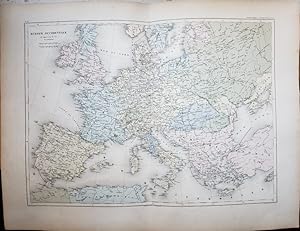
Original Map - "Europe Occidentale, de 962 a 1492 de J.C. [Western Europe, from 962 to 1492 AD]; Pl. 16"; From "Atlas geographique dresse pour l'histoire universelle de l'eglise catholique de l'abbe Rohrbacher" ("Geographical Atlas, Compiled for, the Universal History of the Catholic Church of Abbot Rohrbacher")
Dufour, A. H. (Auguste Henri); Rohrbacher, Rene Francois; Raynaud; Antoine, Louis (Printer); Lahanier et Lansraux
Lingua: Francese
Editore: Gaume Freres et J. Duprey, Editeurs, Paris, France 1861
- Mappa
Da: Barry Cassidy Rare Books, Sacramento, U.S.A.Barry Cassidy Rare Books
Contatta il venditoreVenditore con 5 stelleCondizione: Usato - Molto buono
EUR 89,30
EUR 5,20 spedizioneSpedito in U.S.A.Quantità: 1 disponibili
Aggiungi al carrelloNo Binding. Condizione: Collectible-Very Good. Text is in French. Original publisher's hand-colored map showing "western Europe" between the years 962 and 1492. Map with margins measures 21 1/2" x 16 1/2." Actual map area measures 18" x 13." The vertical center fold line is original as this map came from an atlas. Map is very cl…ean and intact except for some foxing and age toning on front and back (relatively light on front; more pronounced along the edges) and minuscule wear to edges and corners. A Very Good copy. This map shows most of Europe. The top shows Denmark, Norway, Sweden, and the British Isles. Parts of the Grand Duchy of Moscow (present-day Russia) and the Ottoman Empire are to the right. The bottom shows parts of North Africa. Spain, Portugal, and the Atlantic Ocean are to the left. The map features beautiful blue, yellow, green, pink, and orange watercolors within country or regional borders. Major cities and natural features such as mountains, seas, and rivers are included. Scales of distance in the upper-left corner below the title. Lines of latitude and longitude and neatline also included. The following is printed beneath the map below the neatline: "le Trait par Raynaud," "Impie. ['Imprimerie'] de Louis Antoine, 1, rue de Cluny, Paris," and "la Lettre par Lahanier et Lansraux." This map is Plate 16 from an atlas that accompanied "L'Historie universelle de l'eglise catholique" ("Universal History of the Catholic Church"), a notable work by Abbot Rohrbacher. Rene Francois Rohrbacher (1789-1856) was a French priest, ecclesiastical historian, and politician. The main author of this atlas is Auguste Henri Dufour (1795-1865), a French geographer.
Original Map - "Empire d'Occident, sous Charlemagne, de l'an 771 a 814 de J. C. [Western Empire, under Charlemagne, from the year 771 to 814 AD]; Pl. 13"; From "Atlas geographique dresse pour l'histoire universelle de l'eglise catholique de l'abbe Rohrbacher" ("Geographical Atlas, Compiled for, the Universal History of the Catholic Church of Abbot Rohrbacher")
Dufour, A. H. (Auguste Henri); Rohrbacher, Rene Francois; Raynaud; Mme. Fontaine; Antoine, Louis (Printer); Lahanier et Lansraux
Lingua: Francese
Editore: Gaume Freres et J. Duprey, Editeurs, Paris, France 1861
- Mappa
Da: Barry Cassidy Rare Books, Sacramento, U.S.A.Barry Cassidy Rare Books
Contatta il venditoreVenditore con 5 stelleCondizione: Usato - Molto buono
EUR 89,30
EUR 5,20 spedizioneSpedito in U.S.A.Quantità: 1 disponibili
Aggiungi al carrelloNo Binding. Condizione: Collectible-Very Good. Text is in French. Original publisher's hand-colored map showing Europe from the years 771-814 under the reign of Charlemagne. Map with margins measures 21 1/2" x 16 1/2." Actual map area measures 18" x 13." The vertical center fold line is original as this map came from an atlas. M…ap is very clean and intact except for some foxing and age toning (covers the entire front and back but is relatively light on front) and minuscule wear to edges and corners. A Very Good copy. This map is centered on Europe. Spain, the British Isles, Bulgaria, and Aegean Islands are some of the regions that form the outermost borders of the map. The map features beautiful green, yellow, and pink watercolors within country or regional borders. Major cities and natural features such as mountains, seas, and rivers are included. Scales of distance in the upper-left corner below the title. Lines of latitude and longitude and neatline also included. The following is printed beneath the map below the neatline: "Le Trait par Raynaud," "Les Eaux Gravées à la Mécanique par Mme Fontaine," "Impie. ['Imprimerie'] de Louis Antoine, 1, rue de Cluny, Paris," and "La Lettre par Lahanier et Lansraux." This map is Plate 13 from an atlas that accompanied "L'Historie universelle de l'eglise catholique" ("Universal History of the Catholic Church"), a notable work by Abbot Rohrbacher. Rene Francois Rohrbacher (1789-1856) was a French priest, ecclesiastical historian, and politician. The main author of this atlas is Auguste Henri Dufour (1795-1865), a French geographer.
Original Map - "Europe, de l'an 410 a l'an 519 de J. C. [Europe, from the year 410 to the year 519 AD]; Pl. 12"; From "Atlas geographique dresse pour l'histoire universelle de l'eglise catholique de l'abbe Rohrbacher" ("Geographical Atlas, Compiled for, the Universal History of the Catholic Church of Abbot Rohrbacher")
Dufour, A. H. (Auguste Henri); Rohrbacher, Rene Francois; Raynaud; Antoine, Louis (Printer); Lahanier, Lacouchy et Cie.
Lingua: Francese
Editore: Gaume Freres et J. Duprey, Editeurs, Paris, France 1861
- Mappa
Da: Barry Cassidy Rare Books, Sacramento, U.S.A.Barry Cassidy Rare Books
Contatta il venditoreVenditore con 5 stelleCondizione: Usato - Molto buono
EUR 89,30
EUR 5,20 spedizioneSpedito in U.S.A.Quantità: 1 disponibili
Aggiungi al carrelloNo Binding. Condizione: Collectible-Very Good. Text is in French. Original publisher's hand-colored map showing Europe from the years 410 to 519. A line in orange watercolor shows the route of the Huns' invasion into Europe as led by Attila. Map with margins measures 21 1/2" x 16 1/2." Actual map area measures 18" x 13." The ver…tical center fold line is original as this map came from an atlas. Map is very clean and intact except for some foxing and age toning on front and back and minuscule wear to edges and corners. A Very Good copy. This map is centered on Europe. Parts of Africa, Asia, and the Middle East are shown. The map features beautiful blue, yellow, green, and pink watercolors within country or regional borders. A line of orange watercolor shows the route of Attila's invasion. Major cities and natural features such as mountains, seas, and rivers are included. Scales of distance in the upper-left corner below the title. The legend is below the scales of distance. Lines of latitude and longitude and neatline also included. The following is printed beneath the map below the neatline: "Le Trait par Raynaud," "Impie. [Imprimerie] de Louis Antoine, 1, rue de Cluny, Paris," and "Ecrit par Lahanier, Lacouchy et Cie [Compagnie]." This map is Plate 12 from an atlas that accompanied "L'Historie universelle de l'eglise catholique" ("Universal History of the Catholic Church"), a notable work by Abbot Rohrbacher. Rene Francois Rohrbacher (1789-1856) was a French priest, ecclesiastical historian, and politician. The main author of this atlas is Auguste Henri Dufour (1795-1865), a French geographer.
Original Map - "Carte Generale des Croisades, de 1095 a 1270 de J. C. [General Map of the Crusades, from 1095 to 1270 AD]; Pl. 17"; From "Atlas geographique dresse pour l'histoire universelle de l'eglise catholique de l'abbe Rohrbacher" ("Geographical Atlas, Compiled for, the Universal History of the Catholic Church of Abbot Rohrbacher")
Dufour, A. H. (Auguste Henri); Rohrbacher, Rene Francois; Raynaud; Antoine, Louis (Printer); Lahanier et Lansraux
Lingua: Francese
Editore: Gaume Freres et J. Duprey, Editeurs, Paris, France 1861
- Mappa
Da: Barry Cassidy Rare Books, Sacramento, U.S.A.Barry Cassidy Rare Books
Contatta il venditoreVenditore con 5 stelleCondizione: Usato - Molto buono
EUR 89,30
EUR 5,20 spedizioneSpedito in U.S.A.Quantità: 1 disponibili
Aggiungi al carrelloNo Binding. Condizione: Collectible-Very Good. Text is in French. Original publisher's hand-colored map showing the location of the Crusades between the years 1095 and 1270. Map with margins measures 21 1/2" x 16 1/2." Actual map area measures 18" x 13." The vertical center fold line is original as this map came from an atlas. M…ap is very clean and intact except for some foxing and age toning on front and back (relatively light on front; more pronounced along the edges), minuscule wear to edges and corners, and a closed tear measuring 1/2" from the bottom edge (limited to the margins). A Very Good copy. This map shows parts of Europe, North Africa, and the Middle East where the Crusades were fought. The map features beautiful blue, yellow, green, pink, and gray-brown watercolors within country or regional borders. Additional lines in watercolor show the routes of the Crusades and correspond to a legend. The legend labels seven of the Crusades with the following years: 1st Crusade (1096), 2nd Crusade (1147), 3rd Crusade (1189), 4th Crusade (1202), 5th Crusade (1217), 6th Crusade (1228), and 7th Crusade (1248). King Louis IX's Tunis Crusade is the last Crusade named in the legend. Major cities and natural features such as mountains, seas, and rivers are included. Scales of distance in the lower-left corner below the title. Lines of latitude and longitude and neatline also included. The following is printed beneath the map below the neatline: "Le Trait par Raynaud," "Impie. ['Imprimerie'] de Louis Antoine, rue de Cluny, 1, Paris," and "la Lettre par Lahanier et Lansraux." This map is Plate 17 from an atlas that accompanied "L'Historie universelle de l'eglise catholique" ("Universal History of the Catholic Church"), a notable work by Abbot Rohrbacher. Rene Francois Rohrbacher (1789-1856) was a French priest, ecclesiastical historian, and politician. The main author of this atlas is Auguste Henri Dufour (1795-1865), a French geographer.
Original Map - "Europe, de l'an 519 a l'an 771 de J. C. [Europe, from the year 519 to the year 771 AD]; Pl. 14"; From "Atlas geographique dresse pour l'histoire universelle de l'eglise catholique de l'abbe Rohrbacher" ("Geographical Atlas, Compiled for, the Universal History of the Catholic Church of Abbot Rohrbacher")
Dufour, A. H. (Auguste Henri); Rohrbacher, Rene Francois; Raynaud; Mme. Fontaine; Antoine, Louis (Printer); Lahanier et Lansraux
Lingua: Francese
Editore: Gaume Freres et J. Duprey, Editeurs, Paris, France 1861
- Mappa
Da: Barry Cassidy Rare Books, Sacramento, U.S.A.Barry Cassidy Rare Books
Contatta il venditoreVenditore con 5 stelleCondizione: Usato - Molto buono
EUR 89,30
EUR 5,20 spedizioneSpedito in U.S.A.Quantità: 1 disponibili
Aggiungi al carrelloNo Binding. Condizione: Collectible-Very Good. Text is in French. Original publisher's hand-colored map showing Europe from the years 519-771. Map with margins measures 21 1/2" x 16 1/2." Actual map area measures 18" x 13." The vertical center fold line is original as this map came from an atlas. Map is very clean and intact exc…ept for some foxing and age toning (covers the entire front and back but is relatively light on front) and minuscule wear to edges and corners. A Very Good copy. This map is centered on Europe. Parts of the Middle East, Africa, and Asia are also depicted. The map features beautiful blue, yellow, green, and pink watercolors within country or regional borders. Major cities and natural features such as mountains, seas, and rivers are included. Scales of distance in the lower-left corner below the title. Lines of latitude and longitude and neatline also included. The following is printed beneath the map below the neatline: "Le Trait par Raynaud," "Les Eaux Gravées à la Mécanique par Mme Fontaine," "Impie. ['Imprimerie'] de Louis Antoine, 1, rue de Cluny, Paris," and "La Lettre par Lahanier et Lansraux." This map is Plate 14 from an atlas that accompanied "L'Historie universelle de l'eglise catholique" ("Universal History of the Catholic Church"), a notable work by Abbot Rohrbacher. Rene Francois Rohrbacher (1789-1856) was a French priest, ecclesiastical historian, and politician. The main author of this atlas is Auguste Henri Dufour (1795-1865), a French geographer.
Original Map - "Europe Moderne [Modern Europe]; Pl. 21"; From "Atlas geographique dresse pour l'histoire universelle de l'eglise catholique de l'abbe Rohrbacher" ("Geographical Atlas, Compiled for, the Universal History of the Catholic Church of Abbot Rohrbacher")
Dufour, A. H. (Auguste Henri); Rohrbacher, Rene Francois; Raynaud; Antoine, Louis (Printer); Rousset, P.
Lingua: Francese
Editore: Gaume Freres et J. Duprey, Editeurs, Paris, France 1861
- Mappa
Da: Barry Cassidy Rare Books, Sacramento, U.S.A.Barry Cassidy Rare Books
Contatta il venditoreVenditore con 5 stelleCondizione: Usato - Molto buono
EUR 89,30
EUR 5,20 spedizioneSpedito in U.S.A.Quantità: 1 disponibili
Aggiungi al carrelloNo Binding. Condizione: Collectible-Very Good. Text is in French. Original publisher's hand-colored map showing "modern Europe." Map with margins measures 21 1/2" x 16 1/2." Actual map area measures 18" x 13." The vertical center fold line is original as this map came from an atlas. Map is very clean and intact except for some f…oxing and age toning on front and back (relatively light on front; more pronounced along the edges) and minuscule wear to edges and corners. A Very Good copy. This map shows Europe and parts of Africa, the Middle East, and Russia. The map features beautiful blue, yellow, green, and pink watercolors within country or regional borders. Major cities and natural features such as mountains, seas, and rivers are included. Scales of distance in the upper-left corner below the title. Lines of latitude and longitude and neatline also included. The following is printed beneath the map below the neatline: "le Trait par Raynaud," "Impie. ['Imprimerie'] de Louis Antoine, 1, rue de Cluny, Paris," and "la Lettre par P. Rousset." This map is Plate 21 from an atlas that accompanied "L'Historie universelle de l'eglise catholique" ("Universal History of the Catholic Church"), a notable work by Abbot Rohrbacher. Rene Francois Rohrbacher (1789-1856) was a French priest, ecclesiastical historian, and politician. The main author of this atlas is Auguste Henri Dufour (1795-1865), a French geographer.
Original Map - "Palestine, sous, Les Machabees, de 167 a 139 avant J.C. [Palestine, under, The Machabees, from 167 to 139 BC]; Pl. 7"; From "Atlas geographique dresse pour l'histoire universelle de l'eglise catholique de l'abbe Rohrbacher" ("Geographical Atlas, Compiled for, the Universal History of the Catholic Church of Abbot Rohrbacher")
Dufour, A. H. (Auguste Henri); Rohrbacher, Rene Francois; Raynaud; Antoine, Louis (Printer); Lahanier et Lansraux
Lingua: Francese
Editore: Gaume Freres et J. Duprey, Editeurs, Paris, France 1861
- Mappa
Da: Barry Cassidy Rare Books, Sacramento, U.S.A.Barry Cassidy Rare Books
Contatta il venditoreVenditore con 5 stelleCondizione: Usato - Buono
EUR 89,30
EUR 5,20 spedizioneSpedito in U.S.A.Quantità: 1 disponibili
Aggiungi al carrelloNo Binding. Condizione: Collectible-Good. Text is in French. Original publisher's hand-colored map showing Palestine (Judea) from the years 167-139 BCE, under the reign of the Machabees (Maccabees). The Maccabees were a group of Jewish rebel warriors who took control of Judea, which had been controlled by the Seleucid Empire. Af…ter the Maccabees' victory, they established the Hasmonean Dynasty, which ruled from 167 BCE to 37 BCE. Map with margins measures 16 1/2" x 21 1/2." Actual map area measures 13" x 18." The horizontal center fold line is original as this map came from an atlas. Map is clean and intact overall but has some foxing and age toning on front and back and several chips along the edges, which are limited to the margins. A Good copy. This map shows a close-up view of Palestine (Judea). The map features beautiful green, yellow, and pink watercolors. Most of the watercolors are used to demarcate borders or routes. A section of the map is filled in with green watercolor. Major cities and natural features such as mountains, seas, and rivers are included. Scales of distance and a legend are in the lower-right corner. The legend identifies forts and battles won and lost by the Maccabees. Title in upper-left corner. Lines of latitude and longitude and neatline also included. The following is printed beneath the map below the neatline: "Le Trait par Raynaud," "Impie. ['Imprimerie'] de Louis Antoine, 1, rue de Cluny, Paris," and "La Lettre par Lahanier et Lansraux." This map is Plate 7 from an atlas that accompanied "L'Historie universelle de l'eglise catholique" ("Universal History of the Catholic Church"), a notable work by Abbot Rohrbacher. Rene Francois Rohrbacher (1789-1856) was a French priest, ecclesiastical historian, and politician. The main author of this atlas is Auguste Henri Dufour (1795-1865), a French geographer.
Original Map - "Empire Romain d'Orient, a l'epoque de la prise de Jerusalem en 636 de J.C. [Eastern Roman Empire, at the time of the capture of Jerusalem in 636 AD]; Pl. 13"; From "Atlas geographique dresse pour l'histoire universelle de l'eglise catholique de l'abbe Rohrbacher" ("Geographical Atlas, Compiled for, the Universal History of the Catholic Church of Abbot Rohrbacher")
Dufour, A. H. (Auguste Henri); Rohrbacher, Rene Francois; Raynaud; Antoine, Louis (Printer); Lahanier, Lacouchy et Cie.
Lingua: Francese
Editore: Gaume Freres et J. Duprey, Editeurs, Paris, France 1861
- Mappa
Da: Barry Cassidy Rare Books, Sacramento, U.S.A.Barry Cassidy Rare Books
Contatta il venditoreVenditore con 5 stelleCondizione: Usato - Molto buono
EUR 89,30
EUR 5,20 spedizioneSpedito in U.S.A.Quantità: 1 disponibili
Aggiungi al carrelloNo Binding. Condizione: Collectible-Very Good. Text is in French. Original publisher's hand-colored map showing parts of the Middle East, Africa, Europe, and Asia with an emphasis on the Eastern Roman Empire (also known as the Byzantine Empire) and other empires ruling at the time of the Siege of Jerusalem in the year 636. Map w…ith margins measures 21 1/2" x 16 1/2." Actual map area measures 18" x 13." The vertical center fold line is original as this map came from an atlas. Map is very clean and intact except for some foxing and age toning on front and back and minuscule wear to edges and corners. A Very Good copy. This map is roughly centered on Arabia (Empire of Mahomet, or Mehmed). Surrounding areas are shown such as northeastern Africa and parts of Europe and Asia. In addition to the Byzantine Empire and the Empire of Mahomet, the depicted empires include the Tang Dynasty, the Khazars, the Empire of the Avares, and the Sasanian Empire (also, Sassanid Empire, or the Empire of the Iranians). The map features beautiful blue, yellow, green, and pink watercolors. Most, if not all, of the watercolors correspond to the different empires and the lands they control. Major cities and natural features such as mountains, seas, and rivers are included. Scales of distance in the lower-right corner. Title in the lower-left corner. Lines of latitude and longitude and neatline also included. The following is printed beneath the map below the neatline: "Le Trait par Raynaud," "Impie. [Imprimerie] de Louis Antoine, 1, rue de Cluny, Paris," and "Ecrit par Lahanier, Lacouchy et Cie [Compagnie]." This map is Plate 13 from an atlas that accompanied "L'Historie universelle de l'eglise catholique" ("Universal History of the Catholic Church"), a notable work by Abbot Rohrbacher. Rene Francois Rohrbacher (1789-1856) was a French priest, ecclesiastical historian, and politician. The main author of this atlas is Auguste Henri Dufour (1795-1865), a French geographer.
Original Map - "Carte de la Route Suivie par les Hebreux, depuis leur depart de l'Egypte, jusqu'a leur entree dans le pays de Chanaan [Map of the Route followed by the Hebrews, from their departure from Egypt, until their entry into the land of Canaan]; Pl. 3"; From "Atlas geographique dresse pour l'histoire universelle de l'eglise catholique de l'abbe Rohrbacher" ("Geographical Atlas, Compiled for, the Universal History of the Catholic Church of Abbot Rohrbacher")
Dufour, A. H. (Auguste Henri); Rohrbacher, Rene Francois; Blondeau, A.; Antoine, Louis (Printer); Lahanier-Lacouchy
Lingua: Francese
Editore: Gaume Freres et J. Duprey, Editeurs, Paris, France 1861
- Mappa
Da: Barry Cassidy Rare Books, Sacramento, U.S.A.Barry Cassidy Rare Books
Contatta il venditoreVenditore con 5 stelleCondizione: Usato - Molto buono
EUR 89,30
EUR 5,20 spedizioneSpedito in U.S.A.Quantità: 1 disponibili
Aggiungi al carrelloNo Binding. Condizione: Collectible-Very Good. Text is in French. Original publisher's hand-colored map showing the Exodus of the Israelites from Egypt into the land of Canaan. Map with margins measures 16 1/2" x 21 1/2." Actual map area measures 13" x 18." The horizontal center fold line is original as this map came from an atl…as. Map is very clean and intact except for some foxing and age toning on front and back, minuscule wear to edges and corners, and a split measuring about 1/2" from the bottom edge along the fold line. A Very Good copy. Watercolors appear in blue, pink, orange, yellow, and green exclusively as underlines or routes. A legend below the title demarcates the routes taken by different Hebrew people including Abraham, Jacob, and the Israelites. The legend also includes the symbol for "Villes regules du Pays de Chanaan conqueres par Josue" (Regulated towns of the Country of Canaan conquered by Joshua"). Composition is roughly centered around the present-day Sinai Peninsula, which is labeled on the map as part of Arabia Petraea (also, Petrea). Egypt is shown to the west; Canaan (includes present-day Israel) is shown to the north. Part of the Mediterranean Sea and Red Sea are also depicted. Printed at the bottom is "Les noms soulignes appartiennent a la Geographie Moderne" ("The underlined names belong to Modern Geography") which refers to names used at the present time of this map's publication in 1855 (this particular copy appeared in an 1861 atlas). Major cities and natural features such as mountains, seas, and rivers are included. Title, legend, and scales of distance in the lower-left corner. Lines of latitude and longitude and neatline also included. The following is printed beneath the map below the neatline: "Gravee par A. Blondeau aine," "Impie. [Imprimerie] de Louis Antoine, r, des Noyers, 70, Paris," and "Ecrit par Lahanier-Lacouchy." This map is Plate 3 from an atlas that accompanied "L'Historie universelle de l'eglise catholique" ("Universal History of the Catholic Church"), a notable work by Abbot Rohrbacher. Rene Francois Rohrbacher (1789-1856) was a French priest, ecclesiastical historian, and politician. The main author of this atlas is Auguste Henri Dufour (1795-1865), a French geographer.
Original Map - "Empire des Mongols, a l'epoque de Koublai Khan ou Chi Tsou, de l'an 1215 a l'an 1267 de J. C. [Empire of the Mongols, at the time of Koublai Khan or Chi Tsou, from the Year 1215 to the Year 1267 AD]; Pl. 18"; From "Atlas geographique dresse pour l'histoire universelle de l'eglise catholique de l'abbe Rohrbacher" ("Geographical Atlas, Compiled for, the Universal History of the Catholic Church of Abbot Rohrbacher")
Dufour, A. H. (Auguste Henri); Rohrbacher, Rene Francois; Raynaud; Antoine, Louis (Printer); Lahanier et Lansraux
Lingua: Francese
Editore: Gaume Freres et J. Duprey, Editeurs, Paris, France 1861
- Mappa
Da: Barry Cassidy Rare Books, Sacramento, U.S.A.Barry Cassidy Rare Books
Contatta il venditoreVenditore con 5 stelleCondizione: Usato - Molto buono
EUR 89,30
EUR 5,20 spedizioneSpedito in U.S.A.Quantità: 1 disponibili
Aggiungi al carrelloNo Binding. Condizione: Collectible-Very Good. Text is in French. Original publisher's hand-colored map showing the Mongol Empire during the time of Kublai Khan, also known as Chi Tsou, from the years 1215-1267. Map with margins measures 21 1/2" x 16 1/2." Actual map area measures 18" x 13." The vertical center fold line is orig…inal as this map came from an atlas. Map is very clean and intact except for some foxing and age toning on front and back (relatively light on front; more pronounced along the edges) and minuscule wear to edges and corners. A Very Good copy. This map is centered on Asia. Parts of Europe, the Middle East, and Africa are also depicted. The map features beautiful blue, yellow, green, and pink watercolors within country or regional borders. Two additional lines in orange and dark pink watercolors show the routes of two famous explorers who visited the region, Marc Paul (Marco Polo) and Rubruquis (William of Rubruck). A legend shows which of these lines corresponds to which explorer. Major cities and natural features such as mountains, seas, and rivers are included. Scales of distance in the lower-left corner below the title. Lines of latitude and longitude and neatline also included. The following is printed beneath the map below the neatline: "Le Trait par Raynaud," "Impie. ['Imprimerie'] de Louis Antoine, 1, rue de Cluny, Paris," and "La Lettre par Lahanier et Lansraux." This map is Plate 18 from an atlas that accompanied "L'Historie universelle de l'eglise catholique" ("Universal History of the Catholic Church"), a notable work by Abbot Rohrbacher. Rene Francois Rohrbacher (1789-1856) was a French priest, ecclesiastical historian, and politician. The main author of this atlas is Auguste Henri Dufour (1795-1865), a French geographer.
Original Map - "Empire de Cyrus, 538 avant J.C. [Empire of Cyrus, 538 BC]; Pl. 6"; From "Atlas geographique dresse pour l'histoire universelle de l'eglise catholique de l'abbe Rohrbacher" ("Geographical Atlas, Compiled for, the Universal History of the Catholic Church of Abbot Rohrbacher")
Dufour, A. H. (Auguste Henri); Rohrbacher, Rene Francois; Raynaud; Antoine, Louis (Printer); Lahanier-Lacouchy
Lingua: Francese
Editore: Gaume Freres et J. Duprey, Editeurs, Paris, France 1861
- Mappa
Da: Barry Cassidy Rare Books, Sacramento, U.S.A.Barry Cassidy Rare Books
Contatta il venditoreVenditore con 5 stelleCondizione: Usato - Molto buono
EUR 89,30
EUR 5,20 spedizioneSpedito in U.S.A.Quantità: 1 disponibili
Aggiungi al carrelloNo Binding. Condizione: Collectible-Very Good. Text is in French. Original publisher's hand-colored map showing the empire of Cyrus the Great in the year 538 BCE as well as successive rulers. Composition is roughly centered around the Sinai Peninsula. A legend corresponds to lines in pink, orange, and purple watercolors, which s…how the empire's boundaries during Cyrus's reign in the year 538 BCE, the reign of Darius I in 500 BCE, and the reign of Alexander the Great in 300 BCE, respectively. Map with margins measures 21 1/2" x 16 1/2." Actual map area measures 18" x 13." The vertical center fold line is original as this map came from an atlas. Map is very clean and intact except for some foxing and age toning on front and back and minuscule wear to edges and corners. A Very Good copy. Some of the other depicted regions on the map include Egypt, present-day Libya, the Aegean Islands, Macedonia, and Persia. The map features beautiful blue, yellow, green, orange, purple, and pink watercolors within country or regional borders or as outlines. Major cities and natural features such as mountains, seas, and rivers are included. Scales of distance and the legend are in the lower-right corner below the title. Lines of latitude and longitude and neatline also included. The following is printed beneath the map below the neatline: "Le Trait par Raynaud," "Impie. ['Imprimerie'] de Louis Antoine, 1, rue de Cluny, Paris," and "Ecrit par Lahanier-Lacouchy." This map is Plate 6 from an atlas that accompanied "L'Historie universelle de l'eglise catholique" ("Universal History of the Catholic Church"), a notable work by Abbot Rohrbacher. Rene Francois Rohrbacher (1789-1856) was a French priest, ecclesiastical historian, and politician. The main author of this atlas is Auguste Henri Dufour (1795-1865), a French geographer.

Original Map - "Amerique [America]; Pl. 24"; From "Atlas geographique dresse pour l'histoire universelle de l'eglise catholique de l'abbe Rohrbacher" ("Geographical Atlas, Compiled for, the Universal History of the Catholic Church of Abbot Rohrbacher")
Dufour, A. H. (Auguste Henri); Rohrbacher, Rene Francois; Raynaud; Antoine, Louis (Printer); Lahanier et Lansraux
Lingua: Francese
Editore: Gaume Freres et J. Duprey, Editeurs, Paris, France 1861
- Mappa
Da: Barry Cassidy Rare Books, Sacramento, U.S.A.Barry Cassidy Rare Books
Contatta il venditoreVenditore con 5 stelleCondizione: Usato - Molto buono
EUR 89,30
EUR 5,20 spedizioneSpedito in U.S.A.Quantità: 1 disponibili
Aggiungi al carrelloNo Binding. Condizione: Collectible-Very Good. Text is in French. Original publisher's hand-colored map showing North America, Central America, and South America. Map with margins measures 16 1/2" x 21 1/2." Actual map area measures 13 1/4 x 18 1/4." The horizontal center fold line is original as this map came from an atlas. Map… is very clean and intact except for some foxing and age toning (more pronounced along the edges) and minuscule wear to edges and corners. A Very Good copy. While almost entirely dedicated to the Americas, this map includes other geographical regions such as the Arctic Ocean and part of Antarctica. The map features beautiful green, yellow, blue, pink, brown, and purple watercolors which correspond to a legend at bottom. Green represents countries or regions owned by Denmark; yellow, Spain; blue, France; pink, Great Britain; brown, the Netherlands; and purple, Sweden. Watercolors fill in regions or appear as underlines. Major cities and natural features such as mountains, oceans, and rivers are included. Scales of distance in the lower-left corner below the title. Lines of latitude and longitude and neatline also included. The following is printed beneath the map below the neatline: "le Trait par Raynaud," "Impie. ['Imprimerie'] de Louis Antoine, 1, rue de Cluny, Paris," and "la Lettre par Lahanier et Lansraux." This map is Plate 24 from an atlas that accompanied "L'Historie universelle de l'eglise catholique" ("Universal History of the Catholic Church"), a notable work by Abbot Rohrbacher. Rene Francois Rohrbacher (1789-1856) was a French priest, ecclesiastical historian, and politician. The main author of this atlas is Auguste Henri Dufour (1795-1865), a French geographer.
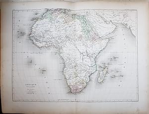
Original Map - "Afrique [Africa]; Pl. 22"; From "Atlas geographique dresse pour l'histoire universelle de l'eglise catholique de l'abbe Rohrbacher" ("Geographical Atlas, Compiled for, the Universal History of the Catholic Church of Abbot Rohrbacher")
Dufour, A. H. (Auguste Henri); Rohrbacher, Rene Francois; Raynaud; Antoine, Louis (Printer); Lahanier et Lansraux
Lingua: Francese
Editore: Gaume Freres et J. Duprey, Editeurs, Paris, France 1861
- Mappa
Da: Barry Cassidy Rare Books, Sacramento, U.S.A.Barry Cassidy Rare Books
Contatta il venditoreVenditore con 5 stelleCondizione: Usato - Molto buono
EUR 89,30
EUR 5,20 spedizioneSpedito in U.S.A.Quantità: 1 disponibili
Aggiungi al carrelloNo Binding. Condizione: Collectible-Very Good. Text is in French. Original publisher's hand-colored map showing Africa and parts of the Middle East. Map with margins measures 21 1/2" x 16 1/2." Actual map area measures 18" x 13." The vertical center fold line is original as this map came from an atlas. Map is very clean and inta…ct except for some foxing and age toning (more pronounced along the edges) and minuscule wear to edges and corners. A Very Good copy. Most of the map shows Africa. The map features beautiful blue, yellow, pale orange, pink and green watercolors within country or regional borders and as outlines. Red underlines appear under some of the names. Major cities and natural features such as mountains, deserts, and rivers are included. Scales of distance in the lower-left corner below the title. Lines of latitude and longitude and neatline also included. The following is printed beneath the map below the neatline: "le Trait par Raynaud," "Impie. ['Imprimerie'] de Louis Antoine, 1, rue de Cluny, Paris," and "la Lettre par Lahanier et Lansraux." This map is Plate 22 from an atlas that accompanied "L'Historie universelle de l'eglise catholique" ("Universal History of the Catholic Church"), a notable work by Abbot Rohrbacher. Rene Francois Rohrbacher (1789-1856) was a French priest, ecclesiastical historian, and politician. The main author of this atlas is Auguste Henri Dufour (1795-1865), a French geographer.
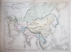
Original Map - "Asie [Asia]; Pl. 23"; From "Atlas geographique dresse pour l'histoire universelle de l'eglise catholique de l'abbe Rohrbacher" ("Geographical Atlas, Compiled for, the Universal History of the Catholic Church of Abbot Rohrbacher")
Dufour, A. H. (Auguste Henri); Rohrbacher, Rene Francois; Raynaud; Antoine, Louis (Printer); Lahanier et Lansraux
Lingua: Francese
Editore: Gaume Freres et J. Duprey, Editeurs, Paris, France 1861
- Mappa
Da: Barry Cassidy Rare Books, Sacramento, U.S.A.Barry Cassidy Rare Books
Contatta il venditoreVenditore con 5 stelleCondizione: Usato - Molto buono
EUR 89,30
EUR 5,20 spedizioneSpedito in U.S.A.Quantità: 1 disponibili
Aggiungi al carrelloNo Binding. Condizione: Collectible-Very Good. Text is in French. Original publisher's hand-colored map showing Asia and parts of Europe, the Middle East, and Africa. Map with margins measures 21 1/2" x 16 1/2." Actual map area measures 18 1/4" x 13 1/4." The vertical center fold line is original as this map came from an atlas.…Map is very clean and intact except for some foxing and age toning (more pronounced along the edges) and minuscule wear to edges and corners. A Very Good copy. Most of the map shows Asia at center. The top shows the Arctic Ocean and Siberia. Parts of Southeast Asia and the Pacific Ocean are to the right. The bottom shows other parts of Southeast Asia including Sumatra and Borneo. Europe, Africa, and Arabia are to the left. The map features beautiful blue, yellow, pink and green watercolors within country or regional borders and meticulously rendered watercolor outlines in blue, yellow, green, and orange. Major cities and natural features such as mountains, deserts, and rivers are also included. Scales of distance in the lower-left corner below the title. Lines of latitude and longitude and neatline also included. The following is printed beneath the map below the neatline: "le Trait par Raynaud," "Impie. ['Imprimerie'] de Louis Antoine, rue de Cluny, 1, Paris," and "la Lettre par Lahanier et Lansraux." This map is Plate 23 from an atlas that accompanied "L'Historie universelle de l'eglise catholique" ("Universal History of the Catholic Church"), a notable work by Abbot Rohrbacher. Rene Francois Rohrbacher (1789-1856) was a French priest, ecclesiastical historian, and politician. The main author of this atlas is Auguste Henri Dufour (1795-1865), a French geographer.
Original Map - "Europe Occidentale, de 1492 a 1519 de J.C. [Western Europe, from 1492 to 1519 by J.C.]; Pl. 20"; From "Atlas geographique dresse pour l'histoire universelle de l'eglise catholique de l'abbe Rohrbacher" ("Geographical Atlas, Compiled for, the Universal History of the Catholic Church of Abbot Rohrbacher")
Dufour, A. H. (Auguste Henri); Rohrbacher, Rene Francois; Raynaud; Antoine, Louis (Printer); Lahanier et Lansraux
Lingua: Francese
Editore: Gaume Freres et J. Duprey, Editeurs, Paris, France 1861
- Mappa
Da: Barry Cassidy Rare Books, Sacramento, U.S.A.Barry Cassidy Rare Books
Contatta il venditoreVenditore con 5 stelleCondizione: Usato - Molto buono
EUR 89,30
EUR 5,20 spedizioneSpedito in U.S.A.Quantità: 1 disponibili
Aggiungi al carrelloNo Binding. Condizione: Collectible-Very Good. Text is in French. Original publisher's hand-colored map showing "western Europe" between the years 1492 and 1519. Map with margins measures 21 1/2" x 16 1/2." Actual map area measures 18" x 13." The vertical center fold line is original as this map came from an atlas. Map is very c…lean and intact except for some foxing and age toning (more pronounced along the edges) and minuscule wear to edges and corners. A Very Good copy. This map shows most of Europe. The top shows Norway, Sweden, and the British Isles. Part of Russia, Crimean Khanate, and regions controlled by the Ottoman Empire are to the right. The bottom shows Italy and part of North Africa. Spain and the Atlantic Ocean are to the left. The map features beautiful blue, yellow, green, and pink watercolors within country or regional borders. Major cities and natural features such as mountains, seas, and rivers are included. Scales of distance in the upper-left corner below the title. Lines of latitude and longitude and neatline also included. The following is printed beneath the map below the neatline: "le Trait par Raynaud," "Impie. ['Imprimerie'] de Louis Antoine, 1, rue de Cluny, Paris," and "la Lettre par Lahanier et Lansraux." This map is Plate 20 from an atlas that accompanied "L'Historie universelle de l'eglise catholique" ("Universal History of the Catholic Church"), a notable work by Abbot Rohrbacher. Rene Francois Rohrbacher (1789-1856) was a French priest, ecclesiastical historian, and politician. The main author of this atlas is Auguste Henri Dufour (1795-1865), a French geographer.
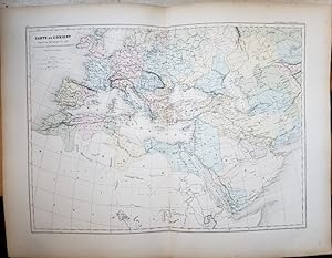
Original Map - "Carte de l'Orient, depuis l'an 636 jusqu'a l'an 1453, de la prise de Constantinople par Mohammed II [Map of the Orient, from the Year 636 to the Year 1453, of the Capture of Constantinople by Mohammed II]; Pl. 19"; From "Atlas geographique dresse pour l'histoire universelle de l'eglise catholique de l'abbe Rohrbacher" ("Geographical Atlas, Compiled for, the Universal History of the Catholic Church of Abbot Rohrbacher")
Dufour, A. H. (Auguste Henri); Rohrbacher, Rene Francois; Raynaud; Antoine, Louis (Printer); Lahanier et Lansraux
Lingua: Francese
Editore: Gaume Freres et J. Duprey, Editeurs, Paris, France 1861
- Mappa
Da: Barry Cassidy Rare Books, Sacramento, U.S.A.Barry Cassidy Rare Books
Contatta il venditoreVenditore con 5 stelleCondizione: Usato - Molto buono
EUR 89,30
EUR 5,20 spedizioneSpedito in U.S.A.Quantità: 1 disponibili
Aggiungi al carrelloNo Binding. Condizione: Collectible-Very Good. Text is in French. Original publisher's hand-colored map showing "the Orient" between the years 636 and 1453. 1453 was the year that Constantinople was captured by Sultan Mehmed II of the Ottoman Empire. Map with margins measures 21 1/2" x 16 1/2." Actual map area measures 18" x 13…1/4." The vertical center fold line is original as this map came from an atlas. Map is very clean and intact except for some foxing and age toning (more pronounced along the edges) and minuscule wear to edges and corners. A Very Good copy. This map shows Arabia, Persia, and parts of northern Africa and Europe. The Mediterranean Sea is pictured roughly center. "Ottoman Empire" is also labeled in French. The map features beautiful blue, yellow, green, and pink watercolors within country or regional borders. Major cities and natural features such as mountains, seas, and rivers are included. Scales of distance in the upper-left corner below the title. Lines of latitude and longitude and neatline also included. The following is printed beneath the map below the neatline: "le Trait par Raynaud," "Impie. ['Imprimerie'] de Louis Antoine, rue de Cluny, 1, Paris," and "la Lettre par Lahanier et Lansraux." This map is Plate 19 from an atlas that accompanied "L'Historie universelle de l'eglise catholique" ("Universal History of the Catholic Church"), a notable work by Abbot Rohrbacher. Rene Francois Rohrbacher (1789-1856) was a French priest, ecclesiastical historian, and politician. The main author of this atlas is Auguste Henri Dufour (1795-1865), a French geographer.
 Altre immagini
Hau Kiou Choaan, histoire chinoise, traduite de l'anglois par M *** [Marc Antoine) Eidous). First edition.
Ming kiao tchong jen, author; Marc-Antoine Eidous (Translator), James Wilkinson (Translator), Thomas Percy (Editor), Louis Buisson (Printer)
Editore: Lyon: Benoi?t Duplain 1766
- Rilegato
Da: Wittenborn Art Books, San Francisco, U.S.A.Wittenborn Art Books
Contatta il venditoreVenditore con 5 stelleCondizione: Usato - Buono
EUR 580,44
EUR 8,67 spedizioneSpedito in U.S.A.Quantità: 1 disponibili
Aggiungi al carrelloCondizione: Good. 12mo, 8.5 x 15.5cm. Half contemporary roan with used marbled boards. 4 vols. in 2: xxxij-224 ; 263, 263 et 243 pages. 4 folding frontispieces. Tear without loss on one half-title.OCLC Number / Unique Identifier:492467802:4 tomes ([1-1bl.-1-1bl.]-XXXII-224 p., [1] f. de pl. dépl. (front.) ; [1-1bl.-1-1bl.]-263-[…1bl.] p., [1] f. de pl. dépl. (front.) ; [1-1bl.-1-1bl.]-263-[1bl.] p., [1] f. de pl. dépl. (front.) ; [1-1bl.-1-1bl.]-243-[4-1bl.] p., [1] f. de pl. dépl. (front.) : ill. ; in-12.OCLC Number / Unique Identifier:492467802Contents:Argument d'une comédie chinoise, jouée a? Canton en 1719 (tome 4, p. 43-68)Fragments de poésie chinoise avec une dissertation (tome 4, p. 69-120)Recueil de proverbes et d'apophthegmes chinois (tome 4, p. 121-243)Notes:L'auteur est connu sous le nom de Ming kiao tchong jenTraduit de l'anglais en français par Marc-Antoine Eidous, d'après BabrierApprobation datée du 22 aou?t 1765 ; privilège daté du 2 octobre 1765 en faveur de Marc-Antoine Eidous, qui le cède a? Benoi?t Duplain, le 15 octobre 1765Marque aux titresSig. : [ ]2 a12 e4 A-I12 K4 ; [ ]2 A-L12 ; [ ]2 A-L12 ; [ ]2 A-K12 L4.Percy's adaptation of Hau Kiou Choaan from an original Chinese novel, and how the ways in which Percy interprets the Chinese novel signify his peculiar views of China. On the title page of Hau Kiou Choaan; or, The Pleasing History (1761), Thomas Percy quotes from Jean-Baptiste Du Halde's A Description of the Empire of China and of Chinese Tartary (1738): 'There is no better means of instruction on China than letting China speak for herself'. It remains questionable, whether by presenting an original piece of Chinese literature, Percy has really let China 'speak for herself'; it is reasonable to argue that Hau Kiou Choaan carries as much information about China as it does about Percy's own perceptions of this country. Whether Percy's works and views of China provoked louder criticism or higher praise, his input into the studies of China was a positive one, for it contributed to an increasingly vigorous debate that would increasingly perceive differences as a source of strength, not weakness.

- Rilegato
- Print on Demand
Da: True World of Books, Delhi, IndiaTrue World of Books
Contatta il venditoreVenditore con 5 stelleCondizione: Nuovo
EUR 21,42
Spedizione gratuitaSpedito da India a U.S.A.Quantità: 18 disponibili
Aggiungi al carrelloLeatherBound. Condizione: New. BOOKS ARE EXEMPT FROM IMPORT DUTIES AND TARIFFS; NO EXTRA CHARGES APPLY. LeatherBound edition. Condition: New. Reprinted from 1789 edition. Leather Binding on Spine and Corners with Golden leaf printing on spine. Bound in genuine leather with Satin ribbon page markers and Spine with raised gilt ban…ds. A perfect gift for your loved ones. Pages: 10 NO changes have been made to the original text. This is NOT a retyped or an ocr'd reprint. Illustrations, Index, if any, are included in black and white. Each page is checked manually before printing. As this print on demand book is reprinted from a very old book, there could be some missing or flawed pages, but we always try to make the book as complete as possible. Fold-outs, if any, are not part of the book. If the original book was published in multiple volumes then this reprint is of only one volume, not the whole set. Sewing binding for longer life, where the book block is actually sewn (smythe sewn/section sewn) with thread before binding which results in a more durable type of binding. Pages: 10 Dumaniant, M. (Antoine-Jean), 1752-1828.,Dumaniant, M. (Antoine-Jean), 1752-1828,Laporte, Antoine-Louis-Guillaume-Catherine, 1746-1817, printer.

- Rilegato
- Print on Demand
Da: True World of Books, Delhi, IndiaTrue World of Books
Contatta il venditoreVenditore con 5 stelleCondizione: Nuovo
EUR 21,42
Spedizione gratuitaSpedito da India a U.S.A.Quantità: 18 disponibili
Aggiungi al carrelloLeatherBound. Condizione: New. BOOKS ARE EXEMPT FROM IMPORT DUTIES AND TARIFFS; NO EXTRA CHARGES APPLY. LeatherBound edition. Condition: New. Reprinted from 1798 edition. Leather Binding on Spine and Corners with Golden leaf printing on spine. Bound in genuine leather with Satin ribbon page markers and Spine with raised gilt ban…ds. A perfect gift for your loved ones. Pages: 42 NO changes have been made to the original text. This is NOT a retyped or an ocr'd reprint. Illustrations, Index, if any, are included in black and white. Each page is checked manually before printing. As this print on demand book is reprinted from a very old book, there could be some missing or flawed pages, but we always try to make the book as complete as possible. Fold-outs, if any, are not part of the book. If the original book was published in multiple volumes then this reprint is of only one volume, not the whole set. Sewing binding for longer life, where the book block is actually sewn (smythe sewn/section sewn) with thread before binding which results in a more durable type of binding. Pages: 42 Ferrie?res-Sauveb?uf, Louis-Franc?ois, comte de, 1762-1814.,Ferrie?res-Sauveb?uf, Louis-Franc?ois, comte de, 1762-1814,Merlin, M. (Philippe-Antoine), 1754-1838,Sche?rer, Barthe?lemy Louis Joseph, 1747-1804,Gorsas, Antoine-Joseph, Veuve, printer.

- Rilegato
- Print on Demand
Da: True World of Books, Delhi, IndiaTrue World of Books
Contatta il venditoreVenditore con 5 stelleCondizione: Nuovo
EUR 21,42
Spedizione gratuitaSpedito da India a U.S.A.Quantità: 18 disponibili
Aggiungi al carrelloLeatherBound. Condizione: New. BOOKS ARE EXEMPT FROM IMPORT DUTIES AND TARIFFS; NO EXTRA CHARGES APPLY. LeatherBound edition. Condition: New. Reprinted from 1789 edition. Leather Binding on Spine and Corners with Golden leaf printing on spine. Bound in genuine leather with Satin ribbon page markers and Spine with raised gilt ban…ds. A perfect gift for your loved ones. Pages: 18 NO changes have been made to the original text. This is NOT a retyped or an ocr'd reprint. Illustrations, Index, if any, are included in black and white. Each page is checked manually before printing. As this print on demand book is reprinted from a very old book, there could be some missing or flawed pages, but we always try to make the book as complete as possible. Fold-outs, if any, are not part of the book. If the original book was published in multiple volumes then this reprint is of only one volume, not the whole set. Sewing binding for longer life, where the book block is actually sewn (smythe sewn/section sewn) with thread before binding which results in a more durable type of binding. Pages: 18 Ce?rutti, Joseph-Antoine-Joachim, 1738-1792.,Ce?rutti, Joseph-Antoine-Joachim, 1738-1792,Noailles, Louis Marie, vicomte de, 1756-1804,Desenne, Victor, publisher,Imprimerie nationale (France), printer.

- Rilegato
- Print on Demand
Da: True World of Books, Delhi, IndiaTrue World of Books
Contatta il venditoreVenditore con 5 stelleCondizione: Nuovo
EUR 21,42
Spedizione gratuitaSpedito da India a U.S.A.Quantità: 18 disponibili
Aggiungi al carrelloLeatherBound. Condizione: New. BOOKS ARE EXEMPT FROM IMPORT DUTIES AND TARIFFS; NO EXTRA CHARGES APPLY. LeatherBound edition. Condition: New. Reprinted from 1791 edition. Leather Binding on Spine and Corners with Golden leaf printing on spine. Bound in genuine leather with Satin ribbon page markers and Spine with raised gilt ban…ds. A perfect gift for your loved ones. Pages: 6 NO changes have been made to the original text. This is NOT a retyped or an ocr'd reprint. Illustrations, Index, if any, are included in black and white. Each page is checked manually before printing. As this print on demand book is reprinted from a very old book, there could be some missing or flawed pages, but we always try to make the book as complete as possible. Fold-outs, if any, are not part of the book. If the original book was published in multiple volumes then this reprint is of only one volume, not the whole set. Sewing binding for longer life, where the book block is actually sewn (smythe sewn/section sewn) with thread before binding which results in a more durable type of binding. Pages: 6 Lecointre, Laurent, d. 1805.,Lecointre, Laurent, d. 1805,Duportail, Antoine-Jean-Louis Le Be?gue de Presle, 1743-1802,Delaguette, Catherine, active 1788-1812, printer.
- Rilegato
- Print on Demand
Da: True World of Books, Delhi, IndiaTrue World of Books
Contatta il venditoreVenditore con 5 stelleCondizione: Nuovo
EUR 21,42
Spedizione gratuitaSpedito da India a U.S.A.Quantità: 18 disponibili
Aggiungi al carrelloLeatherBound. Condizione: New. BOOKS ARE EXEMPT FROM IMPORT DUTIES AND TARIFFS; NO EXTRA CHARGES APPLY. LeatherBound edition. Condition: New. Reprinted from 1626 edition. Leather Binding on Spine and Corners with Golden leaf printing on spine. Bound in genuine leather with Satin ribbon page markers and Spine with raised gilt ban…ds. A perfect gift for your loved ones. Pages: 10 NO changes have been made to the original text. This is NOT a retyped or an ocr'd reprint. Illustrations, Index, if any, are included in black and white. Each page is checked manually before printing. As this print on demand book is reprinted from a very old book, there could be some missing or flawed pages, but we always try to make the book as complete as possible. Fold-outs, if any, are not part of the book. If the original book was published in multiple volumes then this reprint is of only one volume, not the whole set. Sewing binding for longer life, where the book block is actually sewn (smythe sewn/section sewn) with thread before binding which results in a more durable type of binding. Pages: 10.


