Army map service corps engineers (36 risultati)

Editore: U.S. Army, Washington, D.C
- Brossura
- Mappa
Da: Xochi's Bookstore & Gallery, truth or consequences, NM, U.S.A.Xochi's Bookstore & Gallery
Contatta il venditoreVenditore con 2 stelleCondizione: Usato - Molto buono
EUR 26,93
EUR 4,36 spedizioneSpedito in U.S.A.Quantità: 1 disponibili
Paper Back. Condizione: Very Good/Very Good -. Maps; apprx.22x34"; some rub&tan w/wear on edges. all maps Scale 1: 250,000. $30 each. Description: 1: (tan,fold&krinkle,tp.edge) "Gent (Gent, Belgium; Netherlands; France)" 1959 Ed.1-AMS, NM 31-2, M501. (1: 25,000 map on bk.) 2: "Rotterdam (Rotterdam, Netherlands; Belgium; Germany)… 1960 Ed.1-AMS, NM 31-3, M501. (1: 37,500 & 1:50,000 maps on bk.) 3: (3x2"chip,bttm.lt.) "Calais, France" 1955 Ed.1-AMS, NM 31-4, M562. 4: (3x2"chip,tp.lt.w/krinkle&tan,tp.edge) "Burxelles (Bruxelles, Belgium; France; Netherlands; Luxembourg; Germany)" 1955 Ed.1-AMS, NM 31-6, M562. (1: 35,000 & 1: 40,000 maps on bk.) 5: "Le Havre, France" 1955 Ed.1-AMS, NM 31-7, M562. 6: (tan&krinkle,tp.edge) "Paris, France" 1955 Ed.1-AMS, NM 31-11, M562. 7; (some soil&tan w/corner-fold&sml.stain, center bttm.) "Troyes, France" 1961 Ed.1-AMS, NM 31-12, M501.
Editore: U.S. Army, Washington, D.C
- Brossura
- Mappa
Da: Xochi's Bookstore & Gallery, truth or consequences, NM, U.S.A.Xochi's Bookstore & Gallery
Contatta il venditoreVenditore con 2 stelleCondizione: Usato - Molto buono
EUR 26,93
EUR 4,36 spedizioneSpedito in U.S.A.Quantità: 1 disponibili
Paper Back. Condizione: Very Good+/Very Good. Maps; apprx.22x34"; some rub&tan w/wear on edges; PONink stamps. all maps Scale 1: 250,000. $30 each. Description: 1: "La Junta, Colorado; Kansas 1955"--1966 (ltd.rev.of 1964), Ed.2-AMS, Series V502, NJ 13-9. 2: "Durango, Colorado"--1966, NJ 13-7 (7). 3: "Choteau, Montana"--1964 (1st… print.), Ed.2-AMS, Series V502, NL 12-1(some pencil). 4: "Greeley, Colorado; Wyoming"--1965, Ed.2-AMS, V502, NK 13-11. 5(a&b): "Pueblo, Colorado"--1962, Ed.1-AMS(a) & Ed.2-AMS(b), V502, NJ 13-5. 6(a&b): "Cortez, Colorado; Utah"--1964 (1st print.), Ed.2-AMS, V502, NJ 12-9 (a) (2"tear,rt.side) & 1966, NJ 12-9 (b). 7: "Leadville, Colorado"--1963 (1st print.), Ed.2-AMS, V502, NJ 13-1. 8(a&b): "Grand Junction, Colo.; Utah"--1964, Ed.2-AMS. V502, NJ 12-3 (a) & 1965, NJ 12-3. 9: "Wallace, Idaho; Montana"--1959(1st print.), Ed.1-AMS, V502, NL 11-3 (dampstain&krinkle,tp.lt.). 10: "Butte, Montana"--1960 (1st print.), Ed.2-AMS, V502, NL 12-4 (1:25,000 map on bk.) (2). 11: "Ham ilton, Montana; Idaho"--1959 (1st print.), Ed.1-AMS, V502, NL 11-6 (2).
Editore: Washington D. C. 1952
- Mappa
Da: Versandantiquariat Hösl, Neuried, , GermaniaVersandantiquariat Hösl
Contatta il venditoreVenditore con 5 stelleCondizione: Usato - Ottimo
EUR 17,00
EUR 9,50 spedizioneSpedito da Germania a U.S.A.Quantità: 1 disponibili
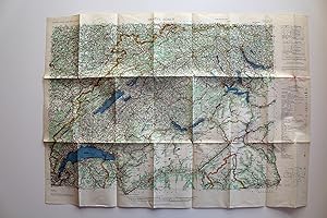
Condizione: Sehr gut. The Army Map Service (AMS) was the military cartographic agency of the United States Department of Defense from 1941 to 1968, subordinated to the United States Army Corps of Engineers.The major task of the Army Map Service was the compilation, publication and distribution of military topographic maps and re…lated products required by the Armed Forces of the United States.Between 1941 and 1945, the Army Map Service prepared 40,000 maps of all types, covering 400,000 square miles of the earth's surface. (WIkipedia) Große farbige Straßenkarte der Zentralschweiz und Teilen der Nachbarländer Franreich, Deutschland und Italien, vielfach gefaltet, praktisch ohne Gebrauchsspuren und wie neu. Legende in Englisch, Französisch und Deutsch. Gefaltet ist die Größe ca. 21,4 x 12,5 cm. AMS M405. First Edition - AMS. Copied in 1952 from kartogr. Anstalt Freytag-Berndt u. Artaria, Wien, 1:300,000, Auto-Strassenkarten, cartes routières, 1951. Sprache / Language: en 1 Seiten. ca. 62,6 x 88 cm.
Editore: Washington D.C. 1952
- Prima edizione
- Mappa
Da: Versandantiquariat Hösl, Neuried, , GermaniaVersandantiquariat Hösl
Contatta il venditoreVenditore con 5 stelleCondizione: Usato - Ottimo
EUR 17,00
EUR 9,50 spedizioneSpedito da Germania a U.S.A.Quantità: 1 disponibili
Condizione: Sehr gut. 1. Auflage. The Army Map Service (AMS) was the military cartographic agency of the United States Department of Defense from 1941 to 1968, subordinated to the United States Army Corps of Engineers.The major task of the Army Map Service was the compilation, publication and distribution of military topographic… maps and related products required by the Armed Forces of the United States.Between 1941 and 1945, the Army Map Service prepared 40,000 maps of all types, covering 400,000 square miles of the earth's surface. (WIkipedia) Große farbige Straßenkarte der Zentralschweiz und Teilen der Nachbarländer Franreich, Deutschland und Italien, vielfach gefaltet, praktisch ohne Gebrauchsspuren und wie neu. Legende in Englisch, Französisch und Deutsch. Gefaltet ist die Größe ca. 21,4 x 12,5 cm. AMS M405. First Edition - AMS. Copied in 1952 from kartogr. Anstalt Freytag-Berndt u. Artaria, Wien, 1:300,000, Auto-Strassenkarten, cartes routières, 1951. Sprache / Language: en 1 Seiten. ca. 62,6 x 88 cm.
Editore: U.S. Army, Washington, D.C
- Brossura
- Mappa
Da: Xochi's Bookstore & Gallery, truth or consequences, NM, U.S.A.Xochi's Bookstore & Gallery
Contatta il venditoreVenditore con 2 stelleCondizione: Usato - Molto buono
EUR 31,42
EUR 4,36 spedizioneSpedito in U.S.A.Quantità: 1 disponibili
Paper Back. Condizione: Very Good+/Very Good. Maps; apprx.22x34"; slight rub&tan w/wear on edges. all maps Scale 1: 250,000. $35 each. Description: 1: "Angers, France" 1955 Ed.1-AMS, NL 30-3, M562. 2: "Tours, France" 1955 Ed.1-AMS, NL 31-1, M562. 3: "Bourges, France" 1955 Ed.1-AMS, NL 31-2, M562. 4: "Dijon, France" 1955 Ed.1-AMS…, NL 31-3, M562. 5: "Zurich (Zurich, Switzerland; Germany; Austria; Liechtenstein)" 1960 Ed.1-AMS, NL 32-2, M501 (1: 35,000 & 1: 25,000 maps on bk.) ( 7: "Rennes, France" 1955, Ed.1-AMS, NM 30-12, M562. 8: "Gent (Gent, Belgium; Netherlands; France)" 1959 Ed.1-AMS, NM 31-2, M501 (1: 25,000 map on bk.). 9: "Rotterdam (Rotterdam, Netherlands; Belgium; Germany)" 1960 Ed.1-AMS, NM 31-3, M501 (1: 37,500 & 1: 50,000 maps on bk.). 10: "Calais, France" 1955 Ed.1-AMS, NM 31-4, M562. 11: "Lille (Lille, France, Belgium)" 1955 Ed.1-AMS, NM 31-5, M562 (1: 35,000 maps on bk.) 12: "Le Havre, France" 1955 Ed.1-AMS, NM 31-7, M562. 13: "Chartres, France" 1955 Ed.1-AMS, NM 31-10, M562 (2). 14: "Paris, France" 1955 Ed.1-AMS, NM 31-11, M562.
Editore: U.S. Army, Washington, D.C 1964
- Brossura
- Mappa
Da: Xochi's Bookstore & Gallery, truth or consequences, NM, U.S.A.Xochi's Bookstore & Gallery
Contatta il venditoreVenditore con 2 stelleCondizione: Usato - Molto buono
EUR 31,42
EUR 4,36 spedizioneSpedito in U.S.A.Quantità: 1 disponibili
Paper Back. Condizione: Very Good+. 1st Printing. Map; apprx.22x34"; slight rub. Daytona Beach, Florida: Edition 2-AMS, Series V501, Sheet # NH 17-8. 1st printing 9-64. Scale 1: 250,000.
Editore: U.S. Army, Washington, D.C 1961
- Brossura
- Mappa
Da: Xochi's Bookstore & Gallery, truth or consequences, NM, U.S.A.Xochi's Bookstore & Gallery
Contatta il venditoreVenditore con 2 stelleCondizione: Usato - Molto buono
EUR 31,42
EUR 4,36 spedizioneSpedito in U.S.A.Quantità: 1 disponibili
Paper Back. Condizione: Very Good+. 1st Printing. Map; apprx.24x34"; slight rub w/lt.tan,tp.edge. Belleville, Illinois, Indiana: Edition 1-AMS, Series V501, Sheet # NJ 16-4. 1st printing 3-61. Scale 1: 250,000 w/ 1: 25,000 (approx.) on back.
Editore: U.S. Army, Washington, D.C 1957
- Brossura
- Mappa
Da: Xochi's Bookstore & Gallery, truth or consequences, NM, U.S.A.Xochi's Bookstore & Gallery
Contatta il venditoreVenditore con 2 stelleCondizione: Usato - Molto buono
EUR 31,42
EUR 4,36 spedizioneSpedito in U.S.A.Quantità: 1 disponibili
Paper Back. Condizione: Very Good+. 1st Printing. Map; apprx.22x34"; slight rub. Key West, Florida: Edition 2-AMS, Series V501, Sheet # NG 17-11. 1st printing 11-57. Scale 1: 250,000.
Editore: U.S. Army, Washington, D.C 1966
- Brossura
- Mappa
Da: Xochi's Bookstore & Gallery, truth or consequences, NM, U.S.A.Xochi's Bookstore & Gallery
Contatta il venditoreVenditore con 2 stelleCondizione: Usato - Molto buono
EUR 31,42
EUR 4,36 spedizioneSpedito in U.S.A.Quantità: 1 disponibili
Paper Back. Condizione: Very Good+. Emergency Printing. Map; 33x31"; white&blk.w/green topo. map; slight rub w/2sml.tear-tape repaired. Edition 1-AMS Series V877S. 1: 25,000.
Editore: U.S. Army, Washington, D.C
- Brossura
- Mappa
Da: Xochi's Bookstore & Gallery, truth or consequences, NM, U.S.A.Xochi's Bookstore & Gallery
Contatta il venditoreVenditore con 2 stelleCondizione: Usato - Molto buono
EUR 31,42
EUR 4,36 spedizioneSpedito in U.S.A.Quantità: 1 disponibili
Paper Back. Condizione: Very Good+/Very Good. Maps; apprx.22x34"; some rub&tan w/wear on edges; PONink stamps. all maps Scale 1: 250,000. $35 each. Description: 1(a&b): "Durango, Colorado 1945"--1973 print, NJ 13-7 (a) & 1976 print, Ed.2-V502, NJ 13-7 (b). 2: "Choteau, Montana"--1957 (1st print), Ed.1-AMS, V502, NL 12-1. 3: "Gre…eley, Colorado; Wyoming"--1964 NS, NK 13-11. 4: "Wallace, Idaho; Montana"--1959 (1st print), Ed.1-AMS, V502, NL 11-3. 5: "Springfield, Missouri"--1958 (1st print), Ed.2-AMS, V502, NJ 15-8 (1: 25,000 map on bk.). 6: "Montrose, Colorado 1956"--1963 (1st print of 1962 ltd.rev.), Ed.2-AMS, V502, NJ 13-4 (2). 7: "Lamar, Colorado; Kansas 1954"--1964 (1st print of 1963 lted.rev.), Ed.2-AMS, V502, NJ 13-6. 8: "Limon, Colorado; Kansas 1954"--1965 print of 1964 ltd.rev., Ed.2-AMS, V502, NJ 13-3. 9: "Pueblo, Colorado 1954"--1966 print of 1962 ltd.rev., NJ 13-5. 10(a&b): "Trinidad, Colorado 1954"--1963 (1st print of 1962 ltd.rev.), Ed.2-AMS, V502, NJ 13-8 (a) & 1963 print of 1962 ltd.rev., NJ 13-8 (2). 11: "Denver, Colorado 1953"--1964 (1st print of 1963 ltd.rev.), Ed.2-AMS, V502, NJ 13-2. 12: "Sterling, Colorado; Nebraska; Kansas 1954"--1964 1st print of ltd.rev., Ed.2-AMS, V502, NK 13-12. 13: "Vernal, Utah; Colorado 1954"--1966 print of 1965 ltd.rev., Ed.2-AMS, V502, NK 12-12.
Lingua: Inglese
Editore: Washington, 1962
- Prima edizione
Da: Books and Beaches, Anna Bechteler, Icking, , GermaniaBooks and Beaches, Anna Bechteler
Contatta il venditoreVenditore con 5 stelleCondizione: Usato - Ottimo
EUR 18,00
EUR 48,00 spedizioneSpedito da Germania a U.S.A.Quantità: 1 disponibili
Condizione: Sehr gut. Folding Map 1: 250.000. Very good condition. Uncommon. Showing the area of Leh/Ladakh. Sprache: Englisch Gewicht in Gramm: 50.
Lingua: Inglese
Editore: Washington, n.d. (ca. 1960). 1960
Da: Books and Beaches, Anna Bechteler, Icking, , GermaniaBooks and Beaches, Anna Bechteler
Contatta il venditoreVenditore con 5 stelleCondizione: Usato - Ottimo
EUR 18,00
EUR 48,00 spedizioneSpedito da Germania a U.S.A.Quantità: 1 disponibili
Condizione: Sehr gut. Folding Map 1: 250.000. As new condition (may be later printing, but not noted as such). Uncommon. Showing the area of Mastuj on the border to Afghanistan. Sprache: Englisch Gewicht in Gramm: 50.
Lingua: Inglese
Editore: Washington, n.d. (ca. 1960). 1960
Da: Books and Beaches, Anna Bechteler, Icking, , GermaniaBooks and Beaches, Anna Bechteler
Contatta il venditoreVenditore con 5 stelleCondizione: Usato - Ottimo
EUR 18,00
EUR 48,00 spedizioneSpedito da Germania a U.S.A.Quantità: 1 disponibili
Condizione: Sehr gut. Folding Map 1: 250.000. As new condition (may be later printing, but not noted as such). Uncommon. Showing the area of Shyok in Ladakh, with Lingzi Tang, Changlung La, Panglung. Sprache: Englisch Gewicht in Gramm: 50.
Lingua: Inglese
Editore: Washington, n.d. (ca. 1960). 1960
Da: Books and Beaches, Anna Bechteler, Icking, , GermaniaBooks and Beaches, Anna Bechteler
Contatta il venditoreVenditore con 5 stelleCondizione: Usato - Ottimo
EUR 18,00
EUR 48,00 spedizioneSpedito da Germania a U.S.A.Quantità: 1 disponibili
Condizione: Sehr gut. Folding Map 1: 250.000. As new condition. Uncommon (may be later printing, but not noted as such). Showing the area of Simla. Sprache: Englisch Gewicht in Gramm: 50.
Lingua: Inglese
Editore: Washington, n.d. (ca. 1960). 1960
Da: Books and Beaches, Anna Bechteler, Icking, , GermaniaBooks and Beaches, Anna Bechteler
Contatta il venditoreVenditore con 5 stelleCondizione: Usato - Ottimo
EUR 18,00
EUR 48,00 spedizioneSpedito da Germania a U.S.A.Quantità: 1 disponibili
Condizione: Sehr gut. Folding Map 1: 250.000. As new condition (may be later printing, but not noted as such). Uncommon. Showing the area of Palampur in Kangra Valley/Himachal Pradesh. Sprache: Englisch Gewicht in Gramm: 50.
Lingua: Inglese
Editore: Washington, n.d. (ca. 1960). 1960
Da: Books and Beaches, Anna Bechteler, Icking, , GermaniaBooks and Beaches, Anna Bechteler
Contatta il venditoreVenditore con 5 stelleCondizione: Usato - Ottimo
EUR 18,00
EUR 48,00 spedizioneSpedito da Germania a U.S.A.Quantità: 1 disponibili
Condizione: Sehr gut. Folding Map 1: 250.000. As new condition (may be later printing, but not noted as such). Uncommon. Showing the area of Mastuj on the border to Afghanistan. Sprache: Englisch Gewicht in Gramm: 50.
Lingua: Inglese
Editore: Washington, n.d. (ca. 1960). 1960
Da: Books and Beaches, Anna Bechteler, Icking, , GermaniaBooks and Beaches, Anna Bechteler
Contatta il venditoreVenditore con 5 stelleCondizione: Usato - Ottimo
EUR 20,00
EUR 48,00 spedizioneSpedito da Germania a U.S.A.Quantità: 1 disponibili
Condizione: Sehr gut. Folding Map 1: 250.000. As new condition. Uncommon (may be later printing, but not noted as such). Showing the area of Kashmir with Srinagar. Sprache: Englisch Gewicht in Gramm: 50.
Lingua: Inglese
Editore: Washington, 1960
Da: Books and Beaches, Anna Bechteler, Icking, , GermaniaBooks and Beaches, Anna Bechteler
Contatta il venditoreVenditore con 5 stelleCondizione: Usato - Ottimo
EUR 20,00
EUR 48,00 spedizioneSpedito da Germania a U.S.A.Quantità: 1 disponibili
Condizione: Sehr gut. Colour folding Map 1: 250.000. As new condition (may be later printing, but not noted as such). Uncommon. Showing the area of Phari with parts of Eastern Bhutan, Tashigang, Tagye, Kyungdu to Taga Dzong. Sprache: Englisch Gewicht in Gramm: 50.
Lingua: Inglese
Editore: Washington, n.d. (ca. 1960). 1960
Da: Books and Beaches, Anna Bechteler, Icking, , GermaniaBooks and Beaches, Anna Bechteler
Contatta il venditoreVenditore con 5 stelleCondizione: Usato - Ottimo
EUR 20,00
EUR 48,00 spedizioneSpedito da Germania a U.S.A.Quantità: 1 disponibili
Condizione: Sehr gut. Colour Folding Map 1: 250.000. As new condition (may be later printing, but not noted as such). Uncommon. Showing the area of Kashmir / Tibet Border with Khunjerab River, Shimshal Pass, Chikar, Koktash. Sprache: Englisch Gewicht in Gramm: 50.
 Altre immagini
Editore: Army Map Service 1944
- Brossura
- Mappa
Da: Librería Miguel Miranda, Lope de Vega n.º XIX, Madrid, M, SpagnaLibrería Miguel Miranda
Contatta il venditoreVenditore con 5 stelleCondizione: Usato
EUR 45,00
EUR 14,95 spedizioneSpedito da Spagna a U.S.A.Quantità: 1 disponibili
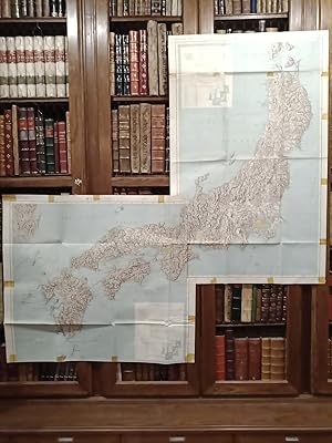
Condizione: Good / Bien. Washington: Army Map Service, [ca. 1959?].- Mapa en colores plegado de 64,5 x 55 cm, Scale 1: 500.000; Refer to this map as: SHEET SB 57-4 Series X401; Texto en inglés. Tan solo tiene los nombres de algunos pueblos o zonas costeras manuscritos a bolígrafo azul. Por lo demás en perfecto estado. Book in en…glish GEOGRAFÍA, GUÍAS Y ATLAS DEL EXTRANJERO.

Editore: Army Map Service 1956
- Brossura
- Mappa
Da: Librería Miguel Miranda, Lope de Vega n.º XIX, Madrid, M, SpagnaLibrería Miguel Miranda
Contatta il venditoreVenditore con 5 stelleCondizione: Usato
EUR 50,00
EUR 14,95 spedizioneSpedito da Spagna a U.S.A.Quantità: 1 disponibili
Condizione: Good / Bien. Washington: Army Map Service, [ca. 1956].- Es un mapa a escala 1 : 25.000 en colores y plegado, de 71 x 54,4 cm; Texto en inglés.- Al verso tiene la totografía aérea del área cartografiada en el mapa. Excelente estado. Book in english GEOGRAFÍA, GUÍAS Y ATLAS DEL EXTRANJERO.
 Altre immagini
Editore: Army Map Service 1952
- Brossura
- Mappa
Da: Librería Miguel Miranda, Lope de Vega n.º XIX, Madrid, M, SpagnaLibrería Miguel Miranda
Contatta il venditoreVenditore con 5 stelleCondizione: Usato
EUR 50,00
EUR 14,95 spedizioneSpedito da Spagna a U.S.A.Quantità: 1 disponibili
Condizione: Good / Bien. Washington: Army Map Service, [ca. 1952].- Mapa en colores plegado de 54,5 x 68,2 cm, Scale 1: 250.000, Location diagram for NF 4-16; Texto en inglés. Excelente estado. Book in english GEOGRAFÍA, GUÍAS Y ATLAS DEL EXTRANJERO.
 Altre immagini
Editore: Army Map Service 1952
- Brossura
- Mappa
Da: Librería Miguel Miranda, Lope de Vega n.º XIX, Madrid, M, SpagnaLibrería Miguel Miranda
Contatta il venditoreVenditore con 5 stelleCondizione: Usato
EUR 60,00
EUR 14,95 spedizioneSpedito da Spagna a U.S.A.Quantità: 1 disponibili
Condizione: Good / Bien. Washington: Army Map Service, [ca. 1952].- Mapa en colores plegado de 55,5 x 72,5 cm, Scale 1: 250.000, Location diagram for NF 4-11; Texto en inglés. Excelente estado. Book in english GEOGRAFÍA, GUÍAS Y ATLAS DEL EXTRANJERO.
 Altre immagini
Lingua: Inglese
Editore: Army Map Service (AMS), Corps of Engineers, Washington DC 1968
- Mappa
Da: Dendera, London, Regno UnitoDendera
Contatta il venditoreVenditore con 5 stelleCondizione: Usato - Molto buono
EUR 89,07
EUR 28,83 spedizioneSpedito da Regno Unito a U.S.A.Quantità: 1 disponibili
No Binding. Condizione: Very Good. Colour printed paper map with 5 insets 91x101cm folding into a printed title panel 13x21cm. Dated 10-68, this is one sheet in a series of six revised and issued during 1963-68 based on World 1/1M Series 1301. Very good, neatly folded. Centred on the Syrian Desert, coverage is bounded by Adana (…NW), Zakho (NE), the Trans-Arabian Pipeline (Tapline) pumping station at Al Uwayqilah (SE), and the UAR Egypt - Israel border (SW). Features include international and military boundaries, 5 road types (hard and loose surface, track and trail), rail, airports and airstrips, drainage, relief, explanatory notes, and an Arabic-English glossary. The courses of Tapline and the Iraq Petroleum Company pipelines are shown. The inset plans are of Damascus, Aleppo, Beirut, Jerusalem, and Amman. The verso repeats the main map in b/w on a 1/1.5M scale, giving military focused phrases in English, Arabic and Turkish (requesting help, water, the location of soldiers etc) and hours of darkness. There are also extensive text descriptions of several distinctive and highly geographical areas from cultivated plains to Saudi sand dunes.
 Altre immagini
Lingua: Inglese
Editore: Army Map Service (AMS), Corps of Engineers, Washington DC 1963
- Mappa
Da: Dendera, London, Regno UnitoDendera
Contatta il venditoreVenditore con 5 stelleCondizione: Usato - Quasi ottimo
EUR 89,07
EUR 28,83 spedizioneSpedito da Regno Unito a U.S.A.Quantità: 1 disponibili
No Binding. Condizione: Near Fine. Colour printed paper map with 5 insets 100x87cm folding into a printed title panel 13x21cm. First printing dated 12-63, this is one sheet in a series of six revised and issued during 1963-68 based on World 1/1M Series 1301. Near fine, neatly folded. Centred on Iran, coverage is bounded by Dogub…eyazit (NW), the Caspian (NE), Isfahan (SE), and Kerbala (SW). Features include international and military boundaries, 5 road types (hard and loose surface, track and trail), rail, airports and airstrips, drainage, relief, explanatory notes, and a glossary. The insets are plans for Al Mawsil, Tehran, Tabriz, Baghdad, and Isfahan. The verso repeats the main map in b/w on a 1/1.5M scale, giving military focused phrases in English, Russian, Arabic, Azerbaijani Turkish, and Persian (requesting help, water, the location of soldiers etc) and hours of darkness. There are also extensive text descriptions of several distinctive and highly geographical areas from desert to cultivated areas.
 Altre immagini
Lingua: Inglese
Editore: Army Map Service (AMS), Corps of Engineers, Washington DC 1964
- Mappa
Da: Dendera, London, Regno UnitoDendera
Contatta il venditoreVenditore con 5 stelleCondizione: Usato - Quasi ottimo
EUR 89,07
EUR 28,83 spedizioneSpedito da Regno Unito a U.S.A.Quantità: 1 disponibili
No Binding. Condizione: Near Fine. Colour printed paper map with 1 inset 99x86cm folding into a printed title panel 13x21cm. First printing dated 3-64, this is one sheet in a series of six revised and issued during 1963-68 based on World 1/1M Series 1301. Near fine except for a small stain to the title panel that has carried thr…ough to the image, neatly folded. Centred on Mashhad, coverage is bounded by Kizyl-Arvat (NW), Bukhara (NE), Farah (SE), and Dasht-e-Lut (SW). Other main settlements included on this sheet are Herat and Ashkhabad. Features include international and military boundaries, 5 road types (hard and loose surface, track and trail), oil pipelines, rail, airports and airstrips, drainage, relief, explanatory notes, and a glossary. Some areas are marked unsurveyed. The inset is a plan for Mashhad. The verso repeats the main map in b/w on a 1/1.5M scale, giving military focused phrases in English, Russian, Persian and Turkish (requesting help, water, the location of soldiers etc) and hours of darkness. There are also extensive text descriptions of several distinctive and highly geographical areas from mountains, to deserts, basins and plains.

Editore: Army Map Service 1954
- Brossura
- Mappa
Da: Librería Miguel Miranda, Lope de Vega n.º XIX, Madrid, M, SpagnaLibrería Miguel Miranda
Contatta il venditoreVenditore con 5 stelleCondizione: Usato
EUR 75,00
EUR 14,95 spedizioneSpedito da Spagna a U.S.A.Quantità: 1 disponibili
Condizione: Good / Bien. Washington: Army Map Service, [ca. 1954?].- Mapa en colores plegado de 142 x 115,3 cm, Scale 1: 250.000; Texto en inglés. Los bordes están reforzados con papel adhesivo. Salvo esto, el mapa en buen estado. Book in english GEOGRAFÍA, GUÍAS Y ATLAS DEL EXTRANJERO.
 Altre immagini
Editore: Army Map Service 1957
- Brossura
- Mappa
Da: Librería Miguel Miranda, Lope de Vega n.º XIX, Madrid, M, SpagnaLibrería Miguel Miranda
Contatta il venditoreVenditore con 5 stelleCondizione: Usato
EUR 80,00
EUR 14,95 spedizioneSpedito da Spagna a U.S.A.Quantità: 1 disponibili
Condizione: Good / Bien. Washington: Army Map Service, [ca.1957?].- Two color maps folded, 102 x 64 cm (Central) and 71 x 75,5 cm (Southern); Scale 1:1.000.000; Texto en inglés. Tienen en los bordes señales de haber estado pegados con papel celofán adhesivo. En general buen estado. Book in english GEOGRAFÍA, GUÍAS Y ATLAS DEL EX…TRANJERO.
 Altre immagini
Lingua: Inglese
Editore: Army Map Service, Corps of Engineers, US Army, Washington DC 1957
- Prima edizione
- Mappa
Da: Dendera, London, Regno UnitoDendera
Contatta il venditoreVenditore con 5 stelleCondizione: Usato - Molto buono
EUR 148,46
EUR 28,83 spedizioneSpedito da Regno Unito a U.S.A.Quantità: 1 disponibili
No Binding. Condizione: Very Good. 1st Edition. Colour printed folding paper map 72x56cm. About very good, neatly folded with ms reference number to the right-hand border and verso. Compiled in 1952 by AMS from Forces Francaises du Levant sheets (dated 1945), and printed by AMS in January 1957 (1-57). The Yazidi district of Sinj…ar in northern Iraq is shown in the lower right quadrant, bounded by the Syrian border. An "Approximate Police Jurisdiction" line runs across its centre, which may relate to the crushing of the Yazidi revolt in 1935 and imposition of military control, which was reimposed and extended in 1939. The rest of the sheet features Syria as far as Sharabin in the east. Details include settlements of different sizes, different grades of road and rail, and extensive geographical features. Around the margins are reliability and location diagrams, legend, scales, glossary, and other data, metadata and instructions. Rare.
 Altre immagini
Lingua: Inglese
Editore: Army Map Service, Corps of Engineers, US Army, (Washington DC) 1967
- Prima edizione
- Mappa
Da: Dendera, London, Regno UnitoDendera
Contatta il venditoreVenditore con 5 stelleCondizione: Usato - Ottimo
EUR 267,22
EUR 28,83 spedizioneSpedito da Regno Unito a U.S.A.Quantità: 1 disponibili
No Binding. Condizione: Fine. 1st Edition. Colour printed paper folding map, 89x98cm. Fine, neatly folded. Printed in July 1967 (7-67), this was issued to inform US strategy in the wake of the Six Day War (5-10 June). Centred on Israel and its neighbours, coverage is bounded by the Gulf of Antalya (NW), Diyarbakir and Tall Afar…(NE), Tabah and Hail (SE), and Nag Hammadi on the Nile (SW) on a 1/1.5M scale. It shows the 1949 Armistice Demarcation (Green) Line. Features include international boundaries (demarcated or undemarcated), populated areas, airfields (including abandoned), railroads (including under construction), primary and secondary roads, and underground oil pipelines and pumping stations (including sections not in use). Rare in commerce. Worldcat also records 2nd and 3rd editions dated 1973.


