
Importo totale (1 articolo articoli):
Destinazione ordine:

burr david h (100 risultati)
Vai alla pagina principale dei risultati di ricerca
Filtri di ricerca
Tipo di articolo
- Tutti i tipi di prodotto
- Libri (63)
- Riviste e Giornali (Nessun altro risultato corrispondente a questo perfezionamento)
- Fumetti (Nessun altro risultato corrispondente a questo perfezionamento)
- Spartiti (Nessun altro risultato corrispondente a questo perfezionamento)
- Arte, Stampe e Poster (28)
- Fotografie (Nessun altro risultato corrispondente a questo perfezionamento)
- Mappe (9)
- Manoscritti e Collezionismo cartaceo (Nessun altro risultato corrispondente a questo perfezionamento)
Condizioni Maggiori informazioni
Legatura
- Tutte
- Rilegato (14)
- Brossura (Nessun altro risultato corrispondente a questo perfezionamento)
Ulteriori caratteristiche
Lingua (2)
Spedizione gratuita
Paese del venditore
Valutazione venditore
-

Contemporary reflections on the medieval Christian tradition: Essays in honor of Ray C. Petry
Lingua: Inglese
Editore: Duke University Press, Durham, North Carolina, 1974
ISBN 10: 0822303043 ISBN 13: 9780822303046
Da: Andover Books and Antiquities, Andover, MA, U.S.A.
Valutazione del venditore 4 su 5 stelle

Hardcover. Condizione: Very good condition. Condizione sovraccoperta: dj. viii, 279 pp. Dustjacket. LCC: 7377639.
-

Witchcraft in Colonial America : Articles On Witchcraft, Magic, And Demonology Vol. 8
Da: Gates Past Books Inc., NY, NY, U.S.A.
Valutazione del venditore 5 su 5 stelle

Prima edizione
Hardcover. Condizione: Fine. 1st Edition. New York & London: Garland Publishing, Inc., 1992. The Garland Full Cloth True First Edition, First Printing, not the Taylor & Francis / Routledge imprint - reprint. A seemingly Unread copy. Light extremity wear, still Fine. First Edition, First Printing. Hard Cover, Cloth, Sewn. Fine/No Jacket, As Issued. 8vo - 9�" tall.
-

Terrorism, interdisciplinary perspectives
Lingua: Inglese
Editore: American Psychiatric Association, 1983
ISBN 10: 0890421099 ISBN 13: 9780890421093
Condizione: New. Satisfaction Guaranteed or your money back.
-
 Edizione Internazionale
OSTEOPOROTIC FRACTURE AND SYSTEMIC SKELETAL DISORDERS MECHANISM ASSESSMENT AND TREATMENT (HB 2022)
Da: UK BOOKS STORE, London, LONDO, Regno Unito
Valutazione del venditore 5 su 5 stelle
EUR 224,18
Spedizione EUR 3,47
Spedito da Regno Unito a U.S.A.Quantit�: 1 disponibili
Aggiungi al carrelloCondizione: New. Brand New! Fast Delivery This is an International Edition and ship within 24-48 hours. Deliver by FedEx and Dhl, & Aramex, UPS, & USPS and we do accept APO and PO BOX Addresses. Order can be delivered worldwide within 6-10 days and we do have flat rate for up to 2LB. Extra shipping charges will be requested if the Book weight is more than 5 LB. This Item May be shipped from India, United states & United Kingdom. Depending on your location and availability.
-

Map of the County of Saratoga
Lingua: Inglese
Editore: David H. Burr, New York, 1829
Da: Argosy Book Store, ABAA, ILAB, New York, NY, U.S.A.
Membro dell'associazione: ABAA ILAB
Valutazione del venditore 5 su 5 stelle
unbound. Rawdon Clark & Co. (illustratore). Map. Copper plate engraving with original hand-coloring. Image measures 12 x 17 1/2". This map depicts Saratoga County in eastern New York, divided into 18 towns outlined in vivid color. The county is bordered by the Hudson River in the east and the Mohawk River in the south. Saratoga Springs is identified. The map denotes major routes, waterways, and topographical details, and icons label villages, flouring mills, factories, forges, saw mills, and churches. This first edition of Burr's county map appeared in his "Atlas of the State of New York" of the same year, which was the second atlas of an individual state ever published. The map is in good condition with light foxing throughout. Full original margins. David H. Burr (1803-1875) served as Topographer to the United States Post Office and Geographer to the House of Representatives and was widely known for his accuracy and attention to detail. His "Universal Atlas" was the first to map each of the United States individually. This map is a lovely rendering of a hard-to-find county in New York State.
-

Map of the County of Tompkins
Editore: Albany, Albany, 1829
Da: High Ridge Books, Inc. - ABAA, South Deerfield, MA, U.S.A.
Membro dell'associazione: ABAA ESA ILAB SNEAB
Valutazione del venditore 5 su 5 stelle
Pocket map in original full leather folder. Folder, somewhat scuffed and worn, has "Tompkins" printed on one side and "Tioga" printed on the back. Clearly, this folder originally also had the Burr map of Tioga County, no longer present. The Tompkins County map is the same as appeared in Burr's landmark 1829 Atlas of New York State, with the printed notation "No. 36" at the top. Linen backed, full color by town. While maps from the Burr atlas are quite uncommon, this format is unique to our experience. We have never previously seen a Burr New York State Atlas map as a separate issue.
-
Ohio
Editore: J.H. Colton, 1839
Da: Schilb Antiquarian, Columbia, MO, U.S.A.
Valutazione del venditore 5 su 5 stelle
Hardcover. Condizione: Near Fine. 1839 HUGE Colton MAP of OHIO David Burr Geography Atlas Cincinnati 19x22in Colton maps are often considered the very best of 19th-century maps. Known for their accuracy and attention to detail, Colton maps have maintained their desirability even into the 21st-century. Cartographers such as David Burr would use Colton to publish their maps. This huge folding map of the state of Ohio was published in New York, bound in a small pocket-size tome. Item number: #14799 Price: $599 BURR, David H. (cartog.) Ohio New York: J.H. Colton, 1839. Details: Binding: Hardcover; tight and secure Cloth Map size: ~19in X 22.5in (48cm x 57cm) Tome size: ~5.25in X 3.25in (13.5cm x 8.5cm) Our Guarantee: Very Fast. Very Safe. Free Shipping Worldwide. Customer satisfaction is our priority! Notify us with 7 days of receiving, and we will offer a full refund without reservation! 14799 Photos available upon request.
-

New York
Editore: New York: David H. Burr, 1832., 1832
Da: Arader Galleries - AraderNYC, New York, NY, U.S.A.
Valutazione del venditore 5 su 5 stelle
Hardcover. Folding engraved pocket map (10 x 12 inches to the neat line; 12 x 13 4/8 inches sheet size), depicting all of New York and an inset of lower Westchester and Long Island lower left, with original hand-colour in full (some browning and separations at folds). Original black roan, gilt. David H. Burr is most notable for his monumental "Atlas of the State of New York, Containing a Map of the State and of the Several Counties" in 1829. Though greatly reduced in format, this is still a detailed map, with each county separately hand-coloured, showing major cities and towns, transport routes and waterways.
-

A Picture of New-York in 1850; with a short account of Places in its Vicinity; designed as a Guide to Citizens and Strangers
Editore: C.S. Francis & Co, New York, 1850
Da: Between the Covers-Rare Books, Inc. ABAA, Gloucester City, NJ, U.S.A.
Membro dell'associazione: ABAA ESA ILAB IOBA
Valutazione del venditore 5 su 5 stelle
Hardcover. Condizione: Very Good. 12mo. xvi, 172, [4]pp., with a folded engraved map: "Map of the City of New York" drawn by D.H. Burr. Illustrated with an engraved frontispiece plate, an added engraved title page, and several other engraved plates of public buildings. The 1850 edition includes a new introduction, and the map by Burr is accompanied with a letterpress street directory. Publisher's red decorative cloth stamped in blind and gold on front cover and spine and in blind only on back cover, cream endpapers. Contemporary owner's name in light pencil on front free endpaper. The boards are rubbed with light wear at the spine ends and corners, the folded map has a few small light creases and one short closed tear, very good or better with some light foxing. An attractive, well-preserved copy of an early New York City Stranger's guide, uncommon in such very good condition. *OCLC* locates only six copies.
-
Memoir, Historical and Political, on the Northwest Coast of North America, and the Adjacent Territories; Illustrated By a Map and a Geographical View of Those Countries - Signed and Inscribed By Author to Historian William Hickling Prescott
Editore: Blair and Rives, Washington, D.C., 1840
Da: RareNonFiction, IOBA, Ladysmith, BC, Canada
Membro dell'associazione: IOBA
Valutazione del venditore 5 su 5 stelle
Prima edizione Copia autografata
EUR 2.618,63
Spedizione EUR 17,23
Spedito da Canada a U.S.A.Quantit�: 1 disponibili
Aggiungi al carrelloHardcover. Condizione: Fair. Burr, David H. (cartographer) (illustratore). First Edition. xi, 227 pages. Index. Fold-out map. Signed and inscribed by author to renowned historian William Hickling Prescott inside front board. Upon front free endpaper a subsequent owner (late 1800s) has documented the provenance of this copy and documented Prescott's pencil markings to pages 23 through 27 which deal with Cortes and Mexico. Occasional light markings to contents. Prior owner's mini-bookplate inside front board. Narrow openings along both hinges. Usual library markings. Fold-out map bears several short openings and a tape repair along right edge. Front free endpaper loose but present. Prior owner's signature atop title page. Above-average external wear to brown marbled boards. WHALE 508, TPL 2369, HOWES G-389, RICKS P.112, TOURVILLE 1850, SMITH 3848, WICKERSHAM 4086. Signed by Author(s).
-
The Steamboat, Stage, and Canal Register, &c. &c. &c. for the Year 1832
Editore: D. H. Burr, New York, 1832
Da: Yesterday's Gallery, ABAA, East Woodstock, CT, U.S.A.
Membro dell'associazione: ABAA ILAB
Valutazione del venditore 5 su 5 stelle
Hardcover. Duodecimo, 5 1/2 x 3 1/5 inches. Brown leather over boards, gilt lettering at front cover, blindstamped borders at edges of covers, sixteen pages, large color fold out map at rear pastedown by David H. Burr (16 1/2 x 13 1/2 inches). Very Good, rubbing to leather heaviest at spine and edges, very light wear to leather overall, front pastedown starting to come unglued but still firmly attached inside, rear hinge cracked but fully attached, pages heavily damp stained and spotted, string weak and broken in some places so text block is loose and slightly cracked at rear hinge but attached, map clean with only some very small holes at certain creased areas.
-
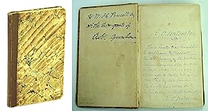
An Atlas of the State of New York, Containing a Map of the State and of the Several Counties. Projected and Drawn by a Uniform Scale from documents deposited in the Public Offices of the State,
Editore: New York: Published by David H. Burr, 1829 [but 1830]., 1830
Da: Arader Galleries - AraderNYC, New York, NY, U.S.A.
Valutazione del venditore 5 su 5 stelle
Prima edizione
Hardcover. Condizione: Very Good. 1st Edition. "Large folio (21 6/8 x 16 4/8 inches). Half-title (four short marginal tears repaired on the verso with tape). Text in double columns (pages 17/18 "Internal Navigation" incorrectly bound between pages 10 and 11, some short marginal tears, occasionally with loss, some repairs to versos). Engraved title-page with vignette "View of the Hudson near Fishkill" (fold strengthened on verso with cloth tape, two short marginal repairs). 52 fine engraved maps with original hand-colour in full "Engravd. by Rawdon, Clark & Co. Albany & Rawdon, Wright & Co., New York" all mounted on guards (some guards renewed, some folds strengthened on verso with cloth tape, some light foxing and offsetting, a few scattered ink stains). Modern half brown morocco over marbled boards by Vogel. Provenance: A few plates with early manuscript annotations, "Map of the County of Hamilton" with three place-names erased. "A LANDMARK DOCUMENT THAT CONSTITUTES ONE OF THE MOST PRECISE CARTOGRAPHIC RECORDS OF THE STATE" (Short) First edition, with all of the maps dated 1829, and rare in any condition. "The Atlas of the State of New York was published in 1830 [although it bears the date 1829]. It was the second state atlas produced in the United States; the very first was the 1825 "Atlas of the State of South Carolina" produced by Robert Mills. Although [Surveyor General Simeon] DeWitt provided information and sponsorship and put his powerful influence behind the project, the producer of the atlas was David Burr (1803-1875).The Burr "Atlas" is a landmark document that constitutes one of the most precise cartographic records of the state. It contains a general map of the state, a large plan of New York City, and maps of each county.The Burr "Atlas" marks a major change. The whole state, the major city, each and every county is depicted in a uniform style and scale, with accompanying standardized statistical information and narrative. The state is given shape and form and substance in the atlas. All the counties are now joined together, a civil union is complete, all the land is subdivided, the marks of progress are recorded and celebrated. " (John Rennie Short, Representing the Republic: Mapping the United States 1600-1900, pp. 85-88). Howes B1017. Phillips, Atlases, 2206. Walter Ristow, American Maps & Mapmakers: Commercial Cartography in the 19th Century, pp. 103-108. Sabin 19873.".
-
Map of the city of New-York, Drawn by D.H. Burr, for "New York as it is in 1835".
Editore: New York: J. Disturnell, 1835., 1835
Da: Arader Galleries - AraderNYC, New York, NY, U.S.A.
Valutazione del venditore 5 su 5 stelle
Hardcover. Engraved folding pocket map (12 x 10 3/8 inches to the neat line), depicting lower Manhattan and Brooklyn, with original hand-colour in part (some separations at folds, some browning). Original red roan, gilt. A detailed and attractive map of lower Manhattan south of Murray Hill Square and Kips Bay, Brooklyn, and Williamsburg, with ferry routes to all. Interestingly showing an area in the East river of proposed development between 22nd and 14th streets that would require landfill. Disturnell and Burr were both enterprising and highly successful publishers of maps. Burr is most notable for his monumental "Atlas of the State of New York, Containing a Map of the State and of the Several Counties" in 1829, and Disturnell perhaps for his important map of the Mexico published in 1847, which was used in official documents of the 1848 Treaty of Hidalgo-Guadeloupe.
-
Ohio.
Editore: Hartford: J. H. Mather & Co., 1846., 1846
Da: Arader Galleries - AraderNYC, New York, NY, U.S.A.
Valutazione del venditore 5 su 5 stelle
Hardcover. Folding engraved map (19 4/8 x 23 inches) with original colour in with inset of Cincinnati lower right (a few minor separations at folds, and strengthened in a few places on verso). Original brown cloth, gilt, labelled on front cover "Colton's map of Ohio". Provenance: existing and potential canals outlined in blue in, and some railroads in red. First published in 1833, and updated since then, to show Ohio's rapid settlement and the creation of new towns and roads since its initial settlement by people from Connecticut. The National Road which crosses the state from east to west is prominently displayed, although by this time railroads were beginning to compete with the Road as a preferred method of moving both freight and people. Phillips, America listing the 1833 edition (page 628).
-

Upper Canada
Editore: Wm. Hall & Co, New York, 1835
Da: Argosy Book Store, ABAA, ILAB, New York, NY, U.S.A.
Membro dell'associazione: ABAA ILAB
Valutazione del venditore 5 su 5 stelle
unbound. Map. Engraving with original hand coloring. 12" x 15". Antique map of Upper Canada (also known as Ontario) divided into districts. Shows towns, major routes, waterways and topographical features. Based on Greenleaf's map of the area but does not include indigenous territories. Slight foxing in Lake Erie. David H. Burr (1803-1875) served as Topographer to the United States Post Office and Geographer to the House of Representatives and was widely known for his accuracy and attention to detail. Burr was one of the first cartographers to map each of the United States individually.
-
![Immagine del venditore per Routes from New York to Montreal and from Albany to Niagara including the springs and other places of fashionable resort [cartographic material] 1842 [LeatherBound] venduto da True World of Books](https://pictures.abebooks.com/inventory/md/md31533757331.jpg)
Routes from New York to Montreal and from Albany to Niagara including the springs and other places of fashionable resort [cartographic material] 1842 [LeatherBound]
Data di pubblicazione: 2025
EUR 21,30
Spedizione gratuita
Spedito da India a U.S.A.Quantit�: 18 disponibili
Aggiungi al carrelloLeatherBound. Condizione: New. BOOKS ARE EXEMPT FROM IMPORT DUTIES AND TARIFFS; NO EXTRA CHARGES APPLY. Leather Binding on Spine and Corners with Golden leaf printing on spine. Bound in genuine leather with Satin ribbon page markers and Spine with raised gilt bands. A perfect gift for your loved ones. Reprinted from 1842 edition. NO changes have been made to the original text. This is NOT a retyped or an ocr'd reprint. Illustrations, Index, if any, are included in black and white. Each page is checked manually before printing. As this print on demand book is reprinted from a very old book, there could be some missing or flawed pages, but we always try to make the book as complete as possible. Fold-outs, if any, are not part of the book. If the original book was published in multiple volumes then this reprint is of only one volume, not the whole set and contains approximately 42 pages. IF YOU WISH TO ORDER PARTICULAR VOLUME OR ALL THE VOLUMES YOU CAN CONTACT US. Resized as per current standards. Sewing binding for longer life, where the book block is actually sewn (smythe sewn/section sewn) with thread before binding which results in a more durable type of binding. Language: English.
-
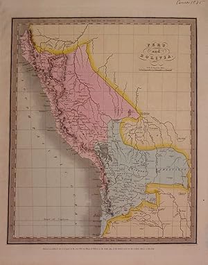
Peru and Bolivia
Editore: Illman & Pilbrow, New York, 1835
Da: Argosy Book Store, ABAA, ILAB, New York, NY, U.S.A.
Membro dell'associazione: ABAA ILAB
Valutazione del venditore 5 su 5 stelle
unbound. Condizione: very good. Map. Engraving with original hand coloring. Image measures 12.75" x 10.5". Shows Lake Titicaca as Bolivian, whereas modern borders share it with Peru.
-
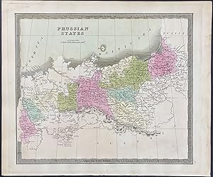
Map of Russia in Europe
Editore: New York, 1836
Da: Trillium Antique Prints & Rare Books, Franklin, TN, U.S.A.
Valutazione del venditore 2 su 5 stelle

Arte / Stampa / Poster
Condizione: Fine. This hand-colored map is from David H. Burr's "A New Universal Atlas; comprising separate maps of all the principal empires, kingdoms & states throughout the world: and forming a distinct atlas of the United States . a new edition revised and corrected to the present time". The work was published in New York in 1836 by William Hall & Co. The maps from the work were engraved by Thomas Illman and Edward Pillbrow. --- David H. Burr (1803-1875) was one of the greatest early American mapmakers. He was born in Connecticut and began his career leading road surveys in southern New York. In 1829, he was responsible for revising Simeon De Witt's map of New York State from 1804. He also served as the topographer for the United States Post Office Department. --- Provenance: Julia H. Alexander (pencilled signature) to original bookend. --- The work is in very good to excellent condition overall. There may be a few minor imperfections or faint marks to be expected with age. Please review the image carefully for condition and contact us with any questions. --- Paper Size ~ 12 1/4" by 14 1/2".
-
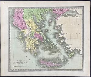
Map of Greece
Editore: New York, 1836
Da: Trillium Antique Prints & Rare Books, Franklin, TN, U.S.A.
Valutazione del venditore 2 su 5 stelle
Arte / Stampa / Poster
Condizione: Fine. This hand-colored map is from David H. Burr's "A New Universal Atlas; comprising separate maps of all the principal empires, kingdoms & states throughout the world: and forming a distinct atlas of the United States . a new edition revised and corrected to the present time". The work was published in New York in 1836 by William Hall & Co. The maps from the work were engraved by Thomas Illman and Edward Pillbrow. --- David H. Burr (1803-1875) was one of the greatest early American mapmakers. He was born in Connecticut and began his career leading road surveys in southern New York. In 1829, he was responsible for revising Simeon De Witt's map of New York State from 1804. He also served as the topographer for the United States Post Office Department. --- Provenance: Julia H. Alexander (pencilled signature) to original bookend. --- The work is in very good to excellent condition overall. There may be a few minor imperfections or faint marks to be expected with age. Please review the image carefully for condition and contact us with any questions. --- Paper Size ~ 12 1/4" by 14 1/2".
-
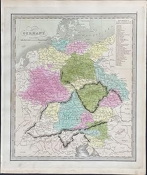
Map of Germany
Editore: New York, 1836
Da: Trillium Antique Prints & Rare Books, Franklin, TN, U.S.A.
Valutazione del venditore 2 su 5 stelle
Arte / Stampa / Poster
Condizione: Fine. This hand-colored map is from David H. Burr's "A New Universal Atlas; comprising separate maps of all the principal empires, kingdoms & states throughout the world: and forming a distinct atlas of the United States . a new edition revised and corrected to the present time". The work was published in New York in 1836 by William Hall & Co. The maps from the work were engraved by Thomas Illman and Edward Pillbrow. --- David H. Burr (1803-1875) was one of the greatest early American mapmakers. He was born in Connecticut and began his career leading road surveys in southern New York. In 1829, he was responsible for revising Simeon De Witt's map of New York State from 1804. He also served as the topographer for the United States Post Office Department. --- Provenance: Julia H. Alexander (pencilled signature) to original bookend. --- The work is in very good to excellent condition overall. There may be a few minor imperfections or faint marks to be expected with age. Please review the image carefully for condition and contact us with any questions. --- Paper Size ~ 12 1/4" by 14 1/2".
-
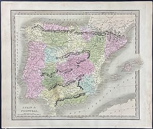
Map of Spain & Portugal
Editore: New York, 1836
Da: Trillium Antique Prints & Rare Books, Franklin, TN, U.S.A.
Valutazione del venditore 2 su 5 stelle
Arte / Stampa / Poster
Condizione: Fine. This hand-colored map is from David H. Burr's "A New Universal Atlas; comprising separate maps of all the principal empires, kingdoms & states throughout the world: and forming a distinct atlas of the United States . a new edition revised and corrected to the present time". The work was published in New York in 1836 by William Hall & Co. The maps from the work were engraved by Thomas Illman and Edward Pillbrow. --- David H. Burr (1803-1875) was one of the greatest early American mapmakers. He was born in Connecticut and began his career leading road surveys in southern New York. In 1829, he was responsible for revising Simeon De Witt's map of New York State from 1804. He also served as the topographer for the United States Post Office Department. --- Provenance: Julia H. Alexander (pencilled signature) to original bookend. --- The work is in very good to excellent condition overall. There may be a few minor imperfections or faint marks to be expected with age. Please review the image carefully for condition and contact us with any questions. --- Paper Size ~ 12 1/4" by 14 1/2".
-
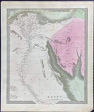
Map of Egypt
Editore: New York, 1836
Da: Trillium Antique Prints & Rare Books, Franklin, TN, U.S.A.
Valutazione del venditore 2 su 5 stelle
Arte / Stampa / Poster
Condizione: Fine. This hand-colored map is from David H. Burr's "A New Universal Atlas; comprising separate maps of all the principal empires, kingdoms & states throughout the world: and forming a distinct atlas of the United States . a new edition revised and corrected to the present time". The work was published in New York in 1836 by William Hall & Co. The maps from the work were engraved by Thomas Illman and Edward Pillbrow. --- David H. Burr (1803-1875) was one of the greatest early American mapmakers. He was born in Connecticut and began his career leading road surveys in southern New York. In 1829, he was responsible for revising Simeon De Witt's map of New York State from 1804. He also served as the topographer for the United States Post Office Department. --- Provenance: Julia H. Alexander (pencilled signature) to original bookend. --- The work is in very good to excellent condition overall. There may be a few minor imperfections or faint marks to be expected with age. Please review the image carefully for condition and contact us with any questions. --- Paper Size ~ 12 1/4" by 14 1/2".
-
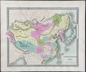
Map of Chinese Empire
Editore: New York, 1836
Da: Trillium Antique Prints & Rare Books, Franklin, TN, U.S.A.
Valutazione del venditore 2 su 5 stelle
Arte / Stampa / Poster
Condizione: Fine. This hand-colored map is from David H. Burr's "A New Universal Atlas; comprising separate maps of all the principal empires, kingdoms & states throughout the world: and forming a distinct atlas of the United States . a new edition revised and corrected to the present time". The work was published in New York in 1836 by William Hall & Co. The maps from the work were engraved by Thomas Illman and Edward Pillbrow. --- David H. Burr (1803-1875) was one of the greatest early American mapmakers. He was born in Connecticut and began his career leading road surveys in southern New York. In 1829, he was responsible for revising Simeon De Witt's map of New York State from 1804. He also served as the topographer for the United States Post Office Department. --- Provenance: Julia H. Alexander (pencilled signature) to original bookend. --- The work is in very good to excellent condition overall. There may be a few minor imperfections or faint marks to be expected with age. Please review the image carefully for condition and contact us with any questions. --- Paper Size ~ 12 1/4" by 14 1/2".
-
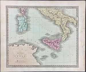
Map of Italy
Editore: New York, 1836
Da: Trillium Antique Prints & Rare Books, Franklin, TN, U.S.A.
Valutazione del venditore 2 su 5 stelle
Arte / Stampa / Poster
Condizione: Fine. This hand-colored map is from David H. Burr's "A New Universal Atlas; comprising separate maps of all the principal empires, kingdoms & states throughout the world: and forming a distinct atlas of the United States . a new edition revised and corrected to the present time". The work was published in New York in 1836 by William Hall & Co. The maps from the work were engraved by Thomas Illman and Edward Pillbrow. --- David H. Burr (1803-1875) was one of the greatest early American mapmakers. He was born in Connecticut and began his career leading road surveys in southern New York. In 1829, he was responsible for revising Simeon De Witt's map of New York State from 1804. He also served as the topographer for the United States Post Office Department. --- Provenance: Julia H. Alexander (pencilled signature) to original bookend. --- The work is in very good to excellent condition overall. There may be a few minor imperfections or faint marks to be expected with age. Please review the image carefully for condition and contact us with any questions. --- Paper Size ~ 12 1/4" by 14 1/2".
-
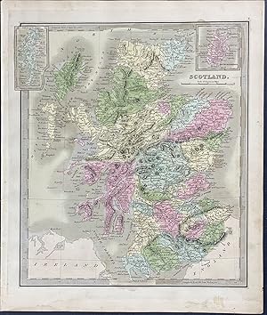
Map of Scotland
Editore: New York, 1836
Da: Trillium Antique Prints & Rare Books, Franklin, TN, U.S.A.
Valutazione del venditore 2 su 5 stelle
Arte / Stampa / Poster
Condizione: Fine. This hand-colored map is from David H. Burr's "A New Universal Atlas; comprising separate maps of all the principal empires, kingdoms & states throughout the world: and forming a distinct atlas of the United States . a new edition revised and corrected to the present time". The work was published in New York in 1836 by William Hall & Co. The maps from the work were engraved by Thomas Illman and Edward Pillbrow. --- David H. Burr (1803-1875) was one of the greatest early American mapmakers. He was born in Connecticut and began his career leading road surveys in southern New York. In 1829, he was responsible for revising Simeon De Witt's map of New York State from 1804. He also served as the topographer for the United States Post Office Department. --- Provenance: Julia H. Alexander (pencilled signature) to original bookend. --- The work is in very good to excellent condition overall. There may be a few minor imperfections or faint marks to be expected with age. Please review the image carefully for condition and contact us with any questions. --- Paper Size ~ 12 1/4" by 14 1/2".
-
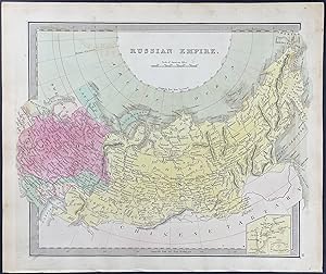
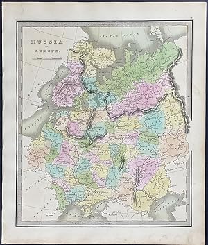
Map of Russian Empire
Editore: New York, 1836
Da: Trillium Antique Prints & Rare Books, Franklin, TN, U.S.A.
Valutazione del venditore 2 su 5 stelle
Arte / Stampa / Poster
Condizione: Fine. This hand-colored map is from David H. Burr's "A New Universal Atlas; comprising separate maps of all the principal empires, kingdoms & states throughout the world: and forming a distinct atlas of the United States . a new edition revised and corrected to the present time". The work was published in New York in 1836 by William Hall & Co. The maps from the work were engraved by Thomas Illman and Edward Pillbrow. --- David H. Burr (1803-1875) was one of the greatest early American mapmakers. He was born in Connecticut and began his career leading road surveys in southern New York. In 1829, he was responsible for revising Simeon De Witt's map of New York State from 1804. He also served as the topographer for the United States Post Office Department. --- Provenance: Julia H. Alexander (pencilled signature) to original bookend. --- The work is in very good to excellent condition overall. There may be a few minor imperfections or faint marks to be expected with age. Please review the image carefully for condition and contact us with any questions. --- Paper Size ~ 12 1/4" by 14 1/2".
-
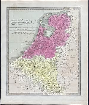
Map of Belgium & Holland
Editore: New York, 1836
Da: Trillium Antique Prints & Rare Books, Franklin, TN, U.S.A.
Valutazione del venditore 2 su 5 stelle
Arte / Stampa / Poster
Condizione: Fine. This hand-colored map is from David H. Burr's "A New Universal Atlas; comprising separate maps of all the principal empires, kingdoms & states throughout the world: and forming a distinct atlas of the United States . a new edition revised and corrected to the present time". The work was published in New York in 1836 by William Hall & Co. The maps from the work were engraved by Thomas Illman and Edward Pillbrow. --- David H. Burr (1803-1875) was one of the greatest early American mapmakers. He was born in Connecticut and began his career leading road surveys in southern New York. In 1829, he was responsible for revising Simeon De Witt's map of New York State from 1804. He also served as the topographer for the United States Post Office Department. --- Provenance: Julia H. Alexander (pencilled signature) to original bookend. --- The work is in very good to excellent condition overall. There may be a few minor imperfections or faint marks to be expected with age. Please review the image carefully for condition and contact us with any questions. --- Paper Size ~ 12 1/4" by 14 1/2".
-
Map of Russia
Editore: New York, 1836
Da: Trillium Antique Prints & Rare Books, Franklin, TN, U.S.A.
Valutazione del venditore 2 su 5 stelle
Arte / Stampa / Poster
Condizione: Fine. This hand-colored map is from David H. Burr's "A New Universal Atlas; comprising separate maps of all the principal empires, kingdoms & states throughout the world: and forming a distinct atlas of the United States . a new edition revised and corrected to the present time". The work was published in New York in 1836 by William Hall & Co. The maps from the work were engraved by Thomas Illman and Edward Pillbrow. --- David H. Burr (1803-1875) was one of the greatest early American mapmakers. He was born in Connecticut and began his career leading road surveys in southern New York. In 1829, he was responsible for revising Simeon De Witt's map of New York State from 1804. He also served as the topographer for the United States Post Office Department. --- Provenance: Julia H. Alexander (pencilled signature) to original bookend. --- The work is in very good to excellent condition overall. There may be a few minor imperfections or faint marks to be expected with age. Please review the image carefully for condition and contact us with any questions. --- Paper Size ~ 12 1/4" by 14 1/2".
-
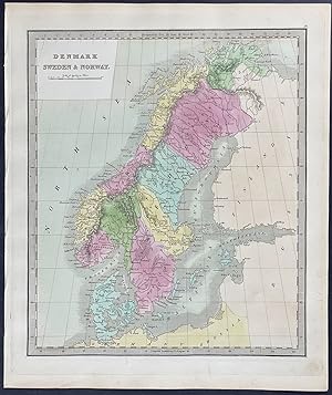
Map of Denmark, Sweden, & Norway
Editore: New York, 1836
Da: Trillium Antique Prints & Rare Books, Franklin, TN, U.S.A.
Valutazione del venditore 2 su 5 stelle
Arte / Stampa / Poster
Condizione: Fine. This hand-colored map is from David H. Burr's "A New Universal Atlas; comprising separate maps of all the principal empires, kingdoms & states throughout the world: and forming a distinct atlas of the United States . a new edition revised and corrected to the present time". The work was published in New York in 1836 by William Hall & Co. The maps from the work were engraved by Thomas Illman and Edward Pillbrow. --- David H. Burr (1803-1875) was one of the greatest early American mapmakers. He was born in Connecticut and began his career leading road surveys in southern New York. In 1829, he was responsible for revising Simeon De Witt's map of New York State from 1804. He also served as the topographer for the United States Post Office Department. --- Provenance: Julia H. Alexander (pencilled signature) to original bookend. --- The work is in very good to excellent condition overall. There may be a few minor imperfections or faint marks to be expected with age. Please review the image carefully for condition and contact us with any questions. --- Paper Size ~ 12 1/4" by 14 1/2".
-
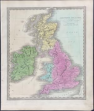
Map of British Islands
Editore: New York, 1836
Da: Trillium Antique Prints & Rare Books, Franklin, TN, U.S.A.
Valutazione del venditore 2 su 5 stelle
Arte / Stampa / Poster
Condizione: Fine. This hand-colored map is from David H. Burr's "A New Universal Atlas; comprising separate maps of all the principal empires, kingdoms & states throughout the world: and forming a distinct atlas of the United States . a new edition revised and corrected to the present time". The work was published in New York in 1836 by William Hall & Co. The maps from the work were engraved by Thomas Illman and Edward Pillbrow. --- David H. Burr (1803-1875) was one of the greatest early American mapmakers. He was born in Connecticut and began his career leading road surveys in southern New York. In 1829, he was responsible for revising Simeon De Witt's map of New York State from 1804. He also served as the topographer for the United States Post Office Department. --- Provenance: Julia H. Alexander (pencilled signature) to original bookend. --- The work is in very good to excellent condition overall. There may be a few minor imperfections or faint marks to be expected with age. Please review the image carefully for condition and contact us with any questions. --- Paper Size ~ 12 1/4" by 14 1/2".


