Importo totale (1 articolo articoli):
Destinazione ordine:

commercial maps (3 risultati)
Vai alla pagina principale dei risultati di ricerca
Filtri di ricerca
Tipo di articolo
- Tutti i tipi di prodotto
- Libri (3)
- Riviste e Giornali (Nessun altro risultato corrispondente a questo perfezionamento)
- Fumetti (Nessun altro risultato corrispondente a questo perfezionamento)
- Spartiti (Nessun altro risultato corrispondente a questo perfezionamento)
- Arte, Stampe e Poster (Nessun altro risultato corrispondente a questo perfezionamento)
- Fotografie (Nessun altro risultato corrispondente a questo perfezionamento)
- Mappe (Nessun altro risultato corrispondente a questo perfezionamento)
- Manoscritti e Collezionismo cartaceo (Nessun altro risultato corrispondente a questo perfezionamento)
Condizioni Maggiori informazioni
- Nuovo (Nessun altro risultato corrispondente a questo perfezionamento)
- Come nuovo, Ottimo o Quasi ottimo (Nessun altro risultato corrispondente a questo perfezionamento)
- Molto buono o Buono (1)
- Discreto o Mediocre (Nessun altro risultato corrispondente a questo perfezionamento)
- Come descritto (2)
Legatura
- Tutte
- Rilegato (1)
- Brossura (Nessun altro risultato corrispondente a questo perfezionamento)
Ulteriori caratteristiche
- Prima ed. (Nessun altro risultato corrispondente a questo perfezionamento)
- Copia autograf. (Nessun altro risultato corrispondente a questo perfezionamento)
- Sovracoperta (Nessun altro risultato corrispondente a questo perfezionamento)
- Con foto (2)
- Non Print on Demand (3)
Lingua (1)
Prezzo
- Qualsiasi prezzo
- Inferiore a EUR 20 (Nessun altro risultato corrispondente a questo perfezionamento)
- EUR 20 a EUR 45 (Nessun altro risultato corrispondente a questo perfezionamento)
- Superiore a EUR 45
Spedizione gratuita
- Spedizione gratuita in U.S.A. (Nessun altro risultato corrispondente a questo perfezionamento)
Paese del venditore
Valutazione venditore
-
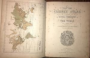
Cabinet Atlas of the Actual Geography of the World, With a Complete Index., 1867, Complete With 34 Coloured Maps
Editore: W & A. K. Johnston, Edinburgh, 1867
Da: Ely Books, ELY, CAMBS, Regno Unito
Valutazione del venditore 5 su 5 stelle

EUR 178,89
Spedizione EUR 24,32
Spedito da Regno Unito a U.S.A.Quantit�: 1 disponibili
Aggiungi al carrelloHard Cover. With a Frontis Physical & Commercial Chart of the World Plus 33 Maps, All Coloured (illustratore). PP: Frontis Map, (v), (i)blank, 33 Maps, 35(index), (i)Advert. Original cloth with "Atlas" in gilt to upper cover. Foxing to the first few pages; otherwise very good. Size: 31.5 X 25.5 Cms.
-

Kent Map
Editore: London . 1708., 1708
Da: Little Stour Books PBFA Member, Canterbury, Regno Unito
Membro dell'associazione: PBFA
Valutazione del venditore 5 su 5 stelle
EUR 77,52
Spedizione EUR 34,74
Spedito da Regno Unito a U.S.A.Quantit�: 1 disponibili
Aggiungi al carrelloUncoloured copper engraved map 8�'' x 7�'' inches. Commonly referred to as 'Miniature Morden's' this map was printed as part of 'Fifty Six New and Accurate Maps of Great Britain' published in conjunction with Herman Moll in 1708. Mounted on contemporary paper with a brown stain to the verso of the right hand margin of the mounting paper, (not the map), folded lines across the top and bottom margins of the map, records society label to the reverse of the map. Member of the P.B.F.A. KENT [Maps].
-

A Map of the Countries Between Constantinople and Calcutta, Including Turkey in Asia, Persia, Afghanistan, and Turkestan
Editore: Edward Stanford
Da: Books From California, Simi Valley, CA, U.S.A.
Valutazione del venditore 4 su 5 stelle

Condizione: Good. This is a large folding coloured linen backed map. Map is clean with minimal wear. No copyright date is given.