
Importo totale (1 articolo articoli):
Destinazione ordine:

engraved dower (14 risultati)
Vai alla pagina principale dei risultati di ricerca
Filtri di ricerca
Tipo di articolo
- Tutti i tipi di prodotto
- Libri (9)
- Riviste e Giornali (Nessun altro risultato corrispondente a questo perfezionamento)
- Fumetti (Nessun altro risultato corrispondente a questo perfezionamento)
- Spartiti (Nessun altro risultato corrispondente a questo perfezionamento)
- Arte, Stampe e Poster (Nessun altro risultato corrispondente a questo perfezionamento)
- Fotografie (Nessun altro risultato corrispondente a questo perfezionamento)
- Mappe (5)
- Manoscritti e Collezionismo cartaceo (Nessun altro risultato corrispondente a questo perfezionamento)
Condizioni Maggiori informazioni
- Nuovo (Nessun altro risultato corrispondente a questo perfezionamento)
- Come nuovo, Ottimo o Quasi ottimo (Nessun altro risultato corrispondente a questo perfezionamento)
- Molto buono o Buono (3)
- Discreto o Mediocre (Nessun altro risultato corrispondente a questo perfezionamento)
- Come descritto (11)
Legatura
- Tutte
- Rilegato (2)
- Brossura (Nessun altro risultato corrispondente a questo perfezionamento)
Ulteriori caratteristiche
- Prima ed. (Nessun altro risultato corrispondente a questo perfezionamento)
- Copia autograf. (Nessun altro risultato corrispondente a questo perfezionamento)
- Sovracoperta (Nessun altro risultato corrispondente a questo perfezionamento)
- Con foto (14)
- Non Print on Demand (14)
Lingua (2)
Spedizione gratuita
- Spedizione gratuita in U.S.A. (Nessun altro risultato corrispondente a questo perfezionamento)
Paese del venditore
Valutazione venditore
-
An engraved antique map of Wiltshire, England
Lingua: Inglese
Data di pubblicazione: 1830
Da: GN Books and Prints, Inverness, Regno Unito
Valutazione del venditore 5 su 5 stelle

Mappa
EUR 14,16
Spedizione EUR 22,58
Spedito da Regno Unito a U.S.A.Quantit�: 1 disponibili
Aggiungi al carrelloNo Binding. Condizione: As Described. No Jacket. Thomas Moule; I. Dower (illustratore). An antique engraved map of Wiltshire, England, engraved by James Bingley, from Thomas Moule's "English Counties Delineated" circa 1830s-1840s. Richly decorated, containing ornate border and a number of vignettes, including coats of arms and illustrations of Salisbury Cathedral and Stonehenge. Displays Reference to the Hundreds. Measures around 8 1/2" x 10 5/8" (216mm x 271mm). The map contains no folds. There are signs of wear with a little tearing, binding holes and creasing at right-hand edge. Extensive foxing and toning, minor other marking. See pictures for further information. 1830s-1840s. n.
-
An engraved antique map of the Isle of Thanet, Kent, England
Lingua: Inglese
Data di pubblicazione: 1830
Da: GN Books and Prints, Inverness, Regno Unito
Valutazione del venditore 5 su 5 stelle
Mappa
EUR 20,58
Spedizione EUR 22,58
Spedito da Regno Unito a U.S.A.Quantit�: 1 disponibili
Aggiungi al carrelloNo Binding. Condizione: As Described. No Jacket. Thomas Moule; I. Dower (illustratore). An antique engraved map of the Isle of Thanet, Kent, England, engraved by I. Dower from Thomas Moule's "English Counties Delineated" circa 1830s-1840s. Contains vignettes, comprising two coats of arms and illustrations of Ramsgate Harbour and North Foreland Light House, together with a scale of English Miles. also title vignette with Latin inscription beneath title. Measures around 10 5/8 x 8 1/2" (270mm x 215mm). The map contains no folds. There are signs of wear with a little tearing at lower edge and a few binding piercing holes, and a little puckering. Some light foxing and toning, with a little other marking. Marking and offsetting to verso. Cropped quite close at right-hand margin and very close at upper margin whereby margin and border are missing. See pictures for further information. 1830s-1840s. n.
-
PHYSICAL MAP OF THE BRITISH ISLES & THE SURROUNDING SEAS, SHOWING THEIR OROGRAPHY, CLIMATOLOGY & SOME BOTANICAL & ZOOLOGICAL FEATURES
Editore: LONDON, CIRCA 1850, 1850
Da: Elder Books, Ross on Wye, Herefordshire, Regno Unito
Valutazione del venditore 5 su 5 stelle
Mappa
EUR 26,64
Spedizione EUR 14,05
Spedito da Regno Unito a U.S.A.Quantit�: 1 disponibili
Aggiungi al carrelloNo Binding. Condizione: Very Good. AN ORIGINAL MID 19th CENTURY MAP, MEASURES APPROX 11 X 8.5 INCHES WITHOUT MARGINS, BLANK REVERSE TO MAP. VERY MINOR MARKS & WRINKLES TO MARGINS, OVERALL IN VERY GOOD PLUS CONDITION. EXTRA POSTAGE COSTS MAY APPLY TO OVERSEAS ORDERS. ALL ITEMS POSTED IN STURDY BOX.
-

South Italy
Editore: Henry Teesdale & Co, London, UK, 1843
Da: Hornseys, Ripon, Regno Unito
Membro dell'associazione: PBFA
Valutazione del venditore 5 su 5 stelle
EUR 42,39
Spedizione EUR 29,40
Spedito da Regno Unito a U.S.A.Quantit�: 1 disponibili
Aggiungi al carrelloNo Binding. Condizione: Very Good Plus. DH302009. Date: 1843. Original engraving with original outline colour. Published in London. Size: 47cm x 38cm with good, wide margins. Blank to the reverse. Minor mark to the base of the map. Short closed tear to the base of the fold line, not affecting the map. A good, strong impression. In very good plus, bright, clean condition overall.
-
Lewis Maps of England. South England 3. North East Division. Handcoloured Map Mounted on Linen.
Editore: S. Lewis and Co. London, 1847
Da: Addyman Books, Hay-on-Wye, Regno Unito
Valutazione del venditore 5 su 5 stelle
Mappa
EUR 90,83
Spedizione EUR 28,22
Spedito da Regno Unito a U.S.A.Quantit�: 1 disponibili
Aggiungi al carrelloS. Lewis and Co. London. 1847. 35 x 42 inch folding coloured map, mounted on linen, in 35 sections (7 by 5). Housed in 20th century grey linen boards with a leather lettering piece - incorrectly stating "Maps of Wales". Some very light foxing otherwise clean and sound.
-
A MAP OF ENGLAND & WALES divided into counties, parliamentary divisions & dioceses shewing the principal roads railways rivers & canals and the seats of the nobility and gentry with the distance of each town from the General Post Office, London Projected from the triangulation for the survey made under the direction of the Honourable The Board of Ordnance on a scale of five miles to an inch and corrected to the present time Drawn by R. Creighton, Engraved by J. Dower. FOUR LARGE FOLDING LINEN BACKED MAPS
Editore: S. Lewis & Co., London, 1841
Da: Andrew Cox PBFA, Shropshire, Regno Unito
Membro dell'associazione: PBFA
Valutazione del venditore 5 su 5 stelle
Mappa
EUR 302,77
Spedizione EUR 22,93
Spedito da Regno Unito a U.S.A.Quantit�: 1 disponibili
Aggiungi al carrelloHardcover. Condizione: Good. Drawn by R. Creighton, Engraved by J. Dower (illustratore). Published in 1841, this is a very large linen backed folding Hand Coloured map of England & Wales, in four parts folding down into leather covers, opened each individual part measures 41.5 inches by 35 inches approx. Put together the whole map measures 83 inches by 70 inches approx. which is nearly 7 feet by 6 feet The leather covers are rubbed and worn at edges, there has been crude strengthening repairs to the spines The map itself has a few creases at edges, mild marking and foxing, else in overall good condition A GENERALLY NICE EXAMPLE OF THIS VERY LARGE EARLY VICTORIAN HAND COLOURED MAP OF ENGLAND AND WALES Maps are heavy, nearly three kilos packed, overseas shipping costs will be significantly higher than the basic standard quote.
-

GERMAN STATES 15.
Editore: London. 1835, 1835
Da: Peter Harrington. ABA/ ILAB., London, Regno Unito
Membro dell'associazione: ABA ILAB PBFA
Valutazione del venditore 5 su 5 stelle
EUR 90,83
Spedizione EUR 25,87
Spedito da Regno Unito a U.S.A.Quantit�: 1 disponibili
Aggiungi al carrelloThis map is from A New General Atlas of the World published by Henry Teesdale & Co. With coloured margins of each state. It shows cities, place names, roads, rivers, lakes, and islands Copper engraving. Very good condition. Original colour. Size: 35 x 43 cm.
-

SOUTH ITALY 29.
Editore: A New General Atlas of the World,. Henry Teesdale & co. 302, High Holborn,. March 1835., 1835
Da: Peter Harrington. ABA/ ILAB., London, Regno Unito
Membro dell'associazione: ABA ILAB PBFA
Valutazione del venditore 5 su 5 stelle
EUR 145,33
Spedizione EUR 25,87
Spedito da Regno Unito a U.S.A.Quantit�: 1 disponibili
Aggiungi al carrelloFull title - A new General Atlas of the World, Compiled from the latest authorities both English and Foreign, Containing separate Maps of its various Countries & States, and exhibiting their boundaries & Divisions, also the Chains of Mountains, Rivers, Lakes and other Goegraphical Features, Comprehended in Forty Six Maps, Including Ancient Maps of Greece, the Roman and Persian Empires & Palestine, from Drawings made Expressly for this work, By John Dower. Paper watermarked J. Whatman 1834. With coloured margins of countries. Shows cities, place names, roads, rivers, lakes, and islands Copper engraving. Very good condition. Original colour. Size: 35 x 43 cm. (14 x 17 inches).
-

CANADA, NEW BRUNSWICK AND NOVA SCOTIA 36.
Editore: London. 1835, 1835
Da: Peter Harrington. ABA/ ILAB., London, Regno Unito
Membro dell'associazione: ABA ILAB PBFA
Valutazione del venditore 5 su 5 stelle
EUR 211,94
Spedizione EUR 25,87
Spedito da Regno Unito a U.S.A.Quantit�: 1 disponibili
Aggiungi al carrelloAn accurate and up to date map of Canada. Published in A New General Atlas of the World by Henry Teesdale & Co. With coloured margins of countries. Shows cities, place names, roads, rivers, lakes, and islands. Copper engraving. Very good condition. Original colour. Size: 35 x 43 cm.
-
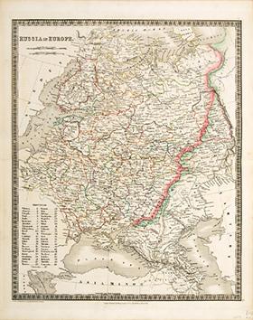
RUSSIA IN EUROPE 9.
Editore: A New General Atlas of the World,. Henry Teesdale & co. 302, High Holborn,. March 1835., 1835
Da: Peter Harrington. ABA/ ILAB., London, Regno Unito
Membro dell'associazione: ABA ILAB PBFA
Valutazione del venditore 5 su 5 stelle
EUR 211,94
Spedizione EUR 25,87
Spedito da Regno Unito a U.S.A.Quantit�: 1 disponibili
Aggiungi al carrelloFull title - A new General Atlas of the World, Compiled from the latest authorities both English and Foreign, Containing separate Maps of its various Countries & States, and exhibiting their boundaries & Divisions, also the Chains of Mountains, Rivers, Lakes and other Goegraphical Features, Comprehended in Forty Six Maps, Including Ancient Maps of Greece, the Roman and Persian Empires & Palestine, from Drawings made Expressly for this work, By John Dower. Paper watermarked J. Whatman 1834. With coloured margins of countries. Shows cities, place names, roads, rivers, lakes, and islands Copper engraving. Very good condition. Original colour. Size: 35 x 43 cm. (14 x 17 inches).
-

SWEDEN AND NORWAY 8.
Editore: A New General Atlas of the World,. Henry Teesdale & co. 302, High Holborn,. March 1835., 1835
Da: Peter Harrington. ABA/ ILAB., London, Regno Unito
Membro dell'associazione: ABA ILAB PBFA
Valutazione del venditore 5 su 5 stelle
EUR 236,16
Spedizione EUR 25,87
Spedito da Regno Unito a U.S.A.Quantit�: 1 disponibili
Aggiungi al carrelloFull title - A new General Atlas of the World, Compiled from the latest authorities both English and Foreign, Containing separate Maps of its various Countries & States, and exhibiting their boundaries & Divisions, also the Chains of Mountains, Rivers, Lakes and other Goegraphical Features, Comprehended in Forty Six Maps, Including Ancient Maps of Greece, the Roman and Persian Empires & Palestine, from Drawings made Expressly for this work, By John Dower. Paper watermarked J. Whatman 1834. With coloured margins of countries. Shows cities, place names, roads, rivers, lakes, and islands Copper engraving. Very good condition. Original colour. Size: 35 x 43 cm. (14 x 17 inches).
-

MAP of the County of CUMBERLAND, from an Actual Survey made in the Years 1821 & 1822.
Editore: London. 1834, 1834
Da: Peter Harrington. ABA/ ILAB., London, Regno Unito
Membro dell'associazione: ABA ILAB PBFA
Valutazione del venditore 5 su 5 stelle
EUR 363,33
Spedizione EUR 25,87
Spedito da Regno Unito a U.S.A.Quantit�: 1 disponibili
Aggiungi al carrelloLarge and attractive map of Cumberland with a detailed and decorative vignette view of Carlisle Cathedral lower right. During the eighteenth century each county map was a separate project sponsored by the local gentry. By 1800 nearly all English counties had been surveyed. In the early nineteenth century two enterprises attempted to survey all the English counties: the brothers Christopher and John Greenwood, and Andrew Bryant. This map comes from the Greenwoods atlas, which was published in parts, but was never completed. H.Wallis "Historian Guide to Early British Maps", p.22 Steel engraving. Very good condition; small repaired tear to top margin; light stains to margins, very slightly affecting the image. Original colour with later additions. Size: 73.5 x 63 cm.
-
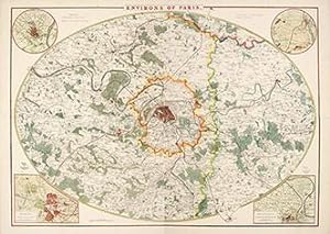
Environs of Paris.
Editore: London. 1858-63, 1858
Da: Peter Harrington. ABA/ ILAB., London, Regno Unito
Membro dell'associazione: ABA ILAB PBFA
Valutazione del venditore 5 su 5 stelle
EUR 363,33
Spedizione EUR 25,87
Spedito da Regno Unito a U.S.A.Quantit�: 1 disponibili
Aggiungi al carrelloAn attractive large oval map of the area around Paris. Four inset maps, one in each corner Versailles, St. Germain en Laye, St. Cloud and Fontainebleu. Title at top centre. Published in The Dispatch Atlas. Weekly Dispatch. Lithograph. Good margins. Fine condition. Later colour. Size: 600 mm x 840 mm. Two sheets joined together.
-
A Map of England and Wales Divided Into Counties Parliamentary Divisons & Dioceses Shewing The Principal Roads Railways Rivers & Canals and the Seats of the Nobility and Gentry with the Distance of Each Town from the General Post Office, London
Editore: Edward Stanford Ltd, London, 1856
Da: George Jeffery Books, HERTFORDSHIRE, Regno Unito
Membro dell'associazione: PBFA
Valutazione del venditore 5 su 5 stelle
EUR 756,93
Spedizione EUR 29,40
Spedito da Regno Unito a U.S.A.Quantit�: 1 disponibili
Aggiungi al carrelloCondizione: Very Good. R. Creighton. Engraved By J. Dower (illustratore). Very large linen backed coloured map, in 4 parts, each part in 30 secition. Map measures 208x178.cm. [ 82x70 inches ]. Some very minor wear. Map in very good clean condition. Without slipcase. F.


