Importo totale (1 articolo articoli):
Destinazione ordine:

great map (76 risultati)
Vai alla pagina principale dei risultati di ricerca
Filtri di ricerca
Tipo di articolo
- Tutti i tipi di prodotto
- Libri (32)
- Riviste e Giornali (1)
- Fumetti (Nessun altro risultato corrispondente a questo perfezionamento)
- Spartiti (Nessun altro risultato corrispondente a questo perfezionamento)
- Arte, Stampe e Poster (Nessun altro risultato corrispondente a questo perfezionamento)
- Fotografie (Nessun altro risultato corrispondente a questo perfezionamento)
- Mappe (43)
- Manoscritti e Collezionismo cartaceo (Nessun altro risultato corrispondente a questo perfezionamento)
Condizioni Maggiori informazioni
- Nuovo (Nessun altro risultato corrispondente a questo perfezionamento)
- Come nuovo, Ottimo o Quasi ottimo (1)
- Molto buono o Buono (40)
- Discreto o Mediocre (Nessun altro risultato corrispondente a questo perfezionamento)
- Come descritto (35)
Legatura
Ulteriori caratteristiche
Lingua (2)
Spedizione gratuita
- Spedizione gratuita in U.S.A. (Nessun altro risultato corrispondente a questo perfezionamento)
Paese del venditore
Valutazione venditore
-

Chester,Connahs Quay,Buckley,Flint,Holywell,Mold Street Atlas
Lingua: Inglese
Editore: Geographers A-Z Map Co Ltd, 2004
ISBN 10: 184348241X ISBN 13: 9781843482413
Da: Reuseabook, Gloucester, GLOS, Regno Unito
Valutazione del venditore 5 su 5 stelle

EUR 3,85
Spedizione EUR 11,59
Spedito da Regno Unito a U.S.A.Quantit�: 1 disponibili
Aggiungi al carrelloPaperback. Condizione: Used; Good. Dispatched, from the UK, within 48 hours of ordering. This book is in good condition but will show signs of previous ownership. Please expect some creasing to the spine and/or minor damage to the cover. Damaged cover. The cover of is slightly damaged for instance a torn or bent corner.
-

EUR 5,97
Spedizione EUR 12,75
Spedito da Regno Unito a U.S.A.Quantit�: 1 disponibili
Aggiungi al carrelloSoft cover. Condizione: Very Good. 44 pages. Janes Davidson "Alexander the Great in Fact and Fiction! / Anthony Grafton "The Lost World of Latin Users" / Philip Kitcher "Can biology be more like Physics?" / Patrick Collinson "The Pilgrimage of Grace and the Politics of the 1530s" / Lorraine Daston "Your map isn't my map" / Andrew saint "The Cambridge Urban History of Britain: Vol.III, 1840-1950.
-

Stonehaven Sheet 43 (Ordnance Survey One-inch Map of Great Britain)
Editore: Ordnance Survey, 1958
Da: WeBuyBooks, Rossendale, LANCS, Regno Unito
Valutazione del venditore 5 su 5 stelle
EUR 10,31
Spedizione EUR 5,33
Spedito da Regno Unito a U.S.A.Quantit�: 1 disponibili
Aggiungi al carrelloCondizione: Good. Most items will be dispatched the same or the next working day. A copy that has been read but remains in clean condition. All of the pages are intact and the cover is intact and the spine may show signs of wear. The book may have minor markings which are not specifically mentioned. A good condition vintage map. Light wear to the cover edges.
-
SUNNYSIDE SUNNY SOUTH OF IRELAND, PART no. 1.KINGDOM OF KERRY.Its Lakes & Fiords. KILLARNEY PARKNASILLA; VALENTIA; GLENGARRIFF &C.DICTRICT.GREAT SOUTHERN AND WESTERN RAILWAY COMPANY'S GUIDES (SUNNY SIDE SOUTH) GREAT SOUTHERN & WESTERN RAILWAY GUIDES; PRICE TWOPENCE
Editore: Published by Publicity Department Great Southern & Western Railway, Kingsbridge, Dublin, Dublin, Ireland, 1910
Da: WONDERFUL BOOKS BY MAIL, CHICO-CA, CA, U.S.A.
Valutazione del venditore 5 su 5 stelle
Prima edizione
Paperback. Condizione: Good. Illustrated by Railroad MAP. Many glossy b&w photos (illustratore). Original Edition 1st ed?. GOOD CONDITION.Quite nice, bit rubs to spines, but otherwise clean, solid,bright text on GLOSSY PAPER STOCK.MANY NICE PHOTOS WITH VERY FEW AUTOMBILES. ; Black titles on orange stiff paper covers, square spine bound. ****THIS IS AN ORIGINAL PUB, NOT A REPRINT.**** ; 87pg thin pages.
-
THE BRITISH EMPIRE SHOWING THE GREAT COMMERCIAL HIGHWAYS - an Original Coloured Map, Printed C1908
Lingua: Inglese
Editore: George Philip & Son/The London Geographical Institute, London, 1908
Da: K Books Ltd ABA ILAB, York, YORKS, Regno Unito
Membro dell'associazione: ABA ILAB PBFA
Valutazione del venditore 5 su 5 stelle
EUR 23,87
Spedizione EUR 22,60
Spedito da Regno Unito a U.S.A.Quantit�: 1 disponibili
Aggiungi al carrelloNo Binding. Condizione: Very Good. An original map, printed in full colour, central fold. Shows the areas of the Empires of the World and their populations in c1908.
-
Plat Book of Benton County, Iowa
Editore: Cedar Valley DAily Times, Vinton, Iowa, 1936
Da: Cambridge Books, Cambridge, MN, U.S.A.
Valutazione del venditore 5 su 5 stelle
Prima edizione
Soft cover. Condizione: Good. 1st Edition. 22 X 28 cm. 44 pages. Date is estimated (after the ending of Prohibition and before WWII, based on ads). A most rare plat map directory of Benton County. As of December, 2020, no copies located in either OCLC or InfoHawk. Most pages a full plat of the County by township, facing a full page of local ads. Some wear and light soiling.
-
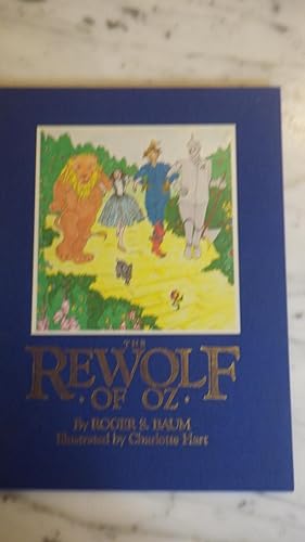
Rewolf of Oz, The SIGNED by Roger S. Baum
Libro 7 di 12: Keepsake Adventures of OzLingua: Inglese
Editore: Green Tiger Press Simon & Schuster, 1990
ISBN 10: 067174982X ISBN 13: 9780671749828
Da: Bluff Park Rare Books, LONG BEACH, CA, U.S.A.
Membro dell'associazione: IOBA
Valutazione del venditore 4 su 5 stelle

Prima edizione Copia autografata
Hardcover. Condizione: Fine. No Jacket. CHARLOTTE HART, (illustratore). 1st Edition. HARDBACK NODJ , 1st edition, 2nd printing , 1990, Oversized Royal blue cloth with color Label of Dorothy & Toto etc with Gold Gilt, FINE/F, NOJACKET, Interior Nice, tight clean, small sticker back bk cover,13 x 9 1/2 inches, 32 pages, Signed by Author.
-
Great Western Railway - Oxford to Chester - an Antique Map
Lingua: Inglese
Data di pubblicazione: 1870
Da: K Books Ltd ABA ILAB, York, YORKS, Regno Unito
Membro dell'associazione: ABA ILAB PBFA
Valutazione del venditore 5 su 5 stelle
EUR 23,87
Spedizione EUR 22,60
Spedito da Regno Unito a U.S.A.Quantit�: 1 disponibili
Aggiungi al carrelloNo Binding. Condizione: Very Good. A splendid original antique coloured map. . Excellent condition. A fine coloured early Railway Map - Great Western Railway - Oxford to Chester .circa 1831 - detailed.
-
GREAT NORTHERN RAILWAY, Sheet 1, London to Grantham & Nottingham - an Original Antique Map, 1860
Lingua: Inglese
Editore: Weekly Dispatch, London, 1860
Da: K Books Ltd ABA ILAB, York, YORKS, Regno Unito
Membro dell'associazione: ABA ILAB PBFA
Valutazione del venditore 5 su 5 stelle
EUR 47,74
Spedizione EUR 22,60
Spedito da Regno Unito a U.S.A.Quantit�: 1 disponibili
Aggiungi al carrelloNo Binding. Condizione: Very Good. Edward WELLER (illustratore). An original antique map, mounted (matted) and ready to frame. No date of publication but c1860. The route of the Great Northern Railway is shown in 4 strips arranged side-by-side with counties coloured in outline. Other railway routes are shown as they join the Great Northern. Some fraying to corners, otherwise good.
-

Michelin Map of Great Britain No. 103: The Southern Highlands
Editore: Published by Michelin Tyre Co. Ltd., 81 Fulham Road, London circa . 1925., 1925
Da: Little Stour Books PBFA Member, Canterbury, Regno Unito
Membro dell'associazione: PBFA
Valutazione del venditore 5 su 5 stelle
EUR 13,13
Spedizione EUR 34,76
Spedito da Regno Unito a U.S.A.Quantit�: 1 disponibili
Aggiungi al carrelloCondizione: Very Good. Publisher's original orange and blue card covered 20 section colour map dissected on canvas opening to 45'' x 19'' and closing to 10'' x 5''. Scale 3.15 miles to an inch. A little rubbing to the edges of card covers and in Very Good clean condition. Member of the P.B.F.A. CARTOGRAPHY, MAPS, PLANS.
-

Michelin Map of Great Britain No. 113: 'Westward Ho'
Editore: Published by Michelin Tyre Co. Ltd., 81 Fulham Road, London circa . 1925., 1925
Da: Little Stour Books PBFA Member, Canterbury, Regno Unito
Membro dell'associazione: PBFA
Valutazione del venditore 5 su 5 stelle
EUR 13,13
Spedizione EUR 34,76
Spedito da Regno Unito a U.S.A.Quantit�: 1 disponibili
Aggiungi al carrelloCondizione: Very Good. Publisher's original orange and blue card covered 20 section colour map dissected on canvas opening to 45'' x 19'' and closing to 10'' x 5''. Scale 3.15 miles to an inch. A little rubbing to the edges of card covers and in Very Good clean condition. Member of the P.B.F.A. CARTOGRAPHY, MAPS, PLANS.
-

Michelin Map of Great Britain No. 106: The Lakes and Moors
Editore: Published by Michelin Tyre Co. Ltd., 81 Fulham Road, London circa . 1925., 1925
Da: Little Stour Books PBFA Member, Canterbury, Regno Unito
Membro dell'associazione: PBFA
Valutazione del venditore 5 su 5 stelle
EUR 13,13
Spedizione EUR 34,76
Spedito da Regno Unito a U.S.A.Quantit�: 1 disponibili
Aggiungi al carrelloCondizione: Very Good. Publisher's original orange and blue card covered 20 section colour map dissected on canvas opening to 45'' x 19'' and closing to 10'' x 5''. Scale 3.15 miles to an inch. A little rubbing to the edges of card covers and in Very Good clean condition. Member of the P.B.F.A. CARTOGRAPHY, MAPS, PLANS.
-

Michelin Map of Great Britain No. 107: Mersey Humber The Peak District
Editore: Published by Michelin Tyre Co. Ltd., 81 Fulham Road, London circa . 1925., 1925
Da: Little Stour Books PBFA Member, Canterbury, Regno Unito
Membro dell'associazione: PBFA
Valutazione del venditore 5 su 5 stelle
EUR 13,13
Spedizione EUR 34,76
Spedito da Regno Unito a U.S.A.Quantit�: 1 disponibili
Aggiungi al carrelloPublisher's original orange and blue card covered 20 section colour map dissected on canvas opening to 45'' x 19'' and closing to 10'' x 5''. Scale 3.15 miles to an inch. A little rubbing to the edges of card covers and an old stain to the front cover. Member of the P.B.F.A. CARTOGRAPHY, MAPS, PLANS.
-

Michelin Map of Great Britain No. 115: The English Riviera
Editore: Published by Michelin Tyre Co. Ltd., 81 Fulham Road, London circa . 1925., 1925
Da: Little Stour Books PBFA Member, Canterbury, Regno Unito
Membro dell'associazione: PBFA
Valutazione del venditore 5 su 5 stelle
EUR 13,13
Spedizione EUR 34,76
Spedito da Regno Unito a U.S.A.Quantit�: 1 disponibili
Aggiungi al carrelloCondizione: Very Good. Publisher's original orange and blue card covered 20 section colour map dissected on canvas opening to 45'' x 19'' and closing to 10'' x 5''. Scale 3.15 miles to an inch. A little rubbing to the edges of card covers and in Very Good clean condition. Member of the P.B.F.A. CARTOGRAPHY, MAPS, PLANS.
-

Michelin Map of Great Britain No. 5: The Border Country
Editore: Published by Michelin Tyre Co. Ltd., 81 Fulham Road, London circa . 1925., 1925
Da: Little Stour Books PBFA Member, Canterbury, Regno Unito
Membro dell'associazione: PBFA
Valutazione del venditore 5 su 5 stelle
EUR 13,13
Spedizione EUR 34,76
Spedito da Regno Unito a U.S.A.Quantit�: 1 disponibili
Aggiungi al carrelloCondizione: Very Good. Publisher's original orange and blue card covered 20 section colour map dissected on canvas opening to 45'' x 19'' and closing to 10'' x 5''. Scale 3.15 miles to an inch. A little rubbing to the edges of card covers and in Very Good clean condition. Member of the P.B.F.A. CARTOGRAPHY, MAPS, PLANS.
-
Lancashire Union Railway. [Showing existing and proposed lines.] [1886.]
Lingua: Inglese
Editore: No place of publication, publisher, or date of publication [?: Lancashire Union Railway ? Post 1886 ?], 1886
Da: Roger J Treglown, ABA., MILNTHORPE, CUMBR, Regno Unito
Membro dell'associazione: ABA ILAB PBFA
Valutazione del venditore 2 su 5 stelle

EUR 149,19
Spedizione EUR 26,65
Spedito da Regno Unito a U.S.A.Quantit�: 1 disponibili
Aggiungi al carrelloSoft cover. Condizione: Very Good. Large Ordnance Survey folding map, 32.5mm x 22.5mm closed. 98mm x 124mm opened out, and is very slightly dusty. One of the folds sometime repaired on the verso. Mounted on linen and dissected in panels. Scale one inch to one statute mail. The map extends in the north to a point north of Preston, and in the south to a point south of Frodsham. In the west to the Rabbit Warrens wset of Formby, and in the east to Manchester The map shows the Manchester, Sheffield and Lincolnshire Railway; London and North Western Railway; Lancashire and Yorkshire Railway; Cheshire Lines Committee [Railway.] ; and the Lancashire Union Railway. Also shown is the -' Proposed St. Helens and Wigan Junctions Railway. ' All the Railways are highlighted in different colours. In addition the map also shows the - '[Ribble] Proposed Training Wall.' Overall, a very good copy of a seemingly unrecorded item. The proposal of a St. Helens and Wigan Junction Railway was first made in 1877, and the line was completed in 1900.
-
Basutoland : Report for the Year 1963
Editore: H.M.S.O., London, 1964
Da: Expatriate Bookshop of Denmark, Svendborg, Danimarca
Valutazione del venditore 5 su 5 stelle
EUR 31,65
Spedizione EUR 55,00
Spedito da Danimarca a U.S.A.Quantit�: 1 disponibili
Aggiungi al carrelloorig. wrappers. Condizione: Rubbed. Good. 13 photoplates; folding map. (illustratore). 21x13cm, 131,[14],pp. Contents: Review of the Main Events of 1963; Progress of Development Schemes; Population; Wages and Labour Organizations; Public Finance and Taxation; Currency and Banking; Weights and Measures; Commerce; Production;Social Services; Legislation and Law office; Justice, Police and Prisons; Public Utilities and Public Works; Communications: Local Government and Community Development; Immigration and Passport Office; Press and Government Information Services; Geography and Climate; History of the Basotho up to 1960; Administration; Reading List.
-
A folding two-colour map of Belgium. Sheet 31
Editore: Ordinance Survey, October 1918., 1918
Da: Clearwater Books, London, Regno Unito
Membro dell'associazione: IOBA
Valutazione del venditore 5 su 5 stelle
Mappa Prima edizione
EUR 41,77
Spedizione EUR 22,36
Spedito da Regno Unito a U.S.A.Quantit�: 1 disponibili
Aggiungi al carrelloNo Binding. Condizione: Very Good. 1st Edition. First edition. Measuring 85cm x 59cm. Cloth-backed paper. Scale 40,000 / 1. Some light soiling and spotting to the cloth backing, and a pencilled former owner name to the folded front panel, accompanied by notations in coloured pencil. A very good copy.
-
A folding colour map of Belgium and part of France. Sheet 37.
Editore: Ordinance Survey Office, March 1917, 1917
Da: Clearwater Books, London, Regno Unito
Membro dell'associazione: IOBA
Valutazione del venditore 5 su 5 stelle
Mappa
EUR 41,77
Spedizione EUR 22,36
Spedito da Regno Unito a U.S.A.Quantit�: 1 disponibili
Aggiungi al carrelloNo Binding. Condizione: Good. 3rd Edition. Third edition. Measuring 90cm x 65.5cm. Cloth-backed paper. Scale 40,000 / 1. Some blemishing and pencilled notations to the margins. A circular area of loss from one upper corner (not impacting the actual map). Some quite light soiling and spotting to the cloth backing. A good copy.
-
A folding colour map of Beuvry, France (36B N.W. 2).
Editore: Ordinance Survey Office, 1916
Da: Clearwater Books, London, Regno Unito
Membro dell'associazione: IOBA
Valutazione del venditore 5 su 5 stelle
Mappa
EUR 41,77
Spedizione EUR 22,36
Spedito da Regno Unito a U.S.A.Quantit�: 1 disponibili
Aggiungi al carrelloNo Binding. Condizione: Very Good. 5th or later Edition. Seventh edition. Measuring 90cm x 68cm. Cloth-backed paper. Scale 10,000 / 1. Some light soiling and spotting to the cloth backing. A very good copy.
-
A folding colour map of North West Europe. Sheet 4 (detailing parts of France and Belgium).
Editore: War Office, London February 1915, 1915
Da: Clearwater Books, London, Regno Unito
Membro dell'associazione: IOBA
Valutazione del venditore 5 su 5 stelle
Mappa
EUR 41,77
Spedizione EUR 22,36
Spedito da Regno Unito a U.S.A.Quantit�: 1 disponibili
Aggiungi al carrelloNo Binding. Condizione: Very Good. Revised edition. Measuring 86cm x 68cm. Cloth-backed paper. Scale 250,000 / 1. Several areas of soiling to the margins (not impacting the actual map). Some light soiling and spotting to the cloth backing. One small corner of loss (not impacting map). A very good copy.
-
A folding colour map of North West Europe. Sheet 2 (detailing parts of The Netherlands, Belgium, and Germany).
Editore: War Office, London February 1916., 1916
Da: Clearwater Books, London, Regno Unito
Membro dell'associazione: IOBA
Valutazione del venditore 5 su 5 stelle
Mappa
EUR 41,77
Spedizione EUR 22,36
Spedito da Regno Unito a U.S.A.Quantit�: 1 disponibili
Aggiungi al carrelloNo Binding. Condizione: Very Good. Revised edition. Measuring 86cm x 66cm. Cloth-backed paper. Scale 250,000 / 1. Some light soiling and spotting to the cloth backing. A very good copy.
-
A folding two-colour map of Belgium. Sheet 38.
Editore: [no publisher / no date. C.1918]., 1918
Da: Clearwater Books, London, Regno Unito
Membro dell'associazione: IOBA
Valutazione del venditore 5 su 5 stelle
Mappa
EUR 41,77
Spedizione EUR 22,36
Spedito da Regno Unito a U.S.A.Quantit�: 1 disponibili
Aggiungi al carrelloNo Binding. Condizione: Very Good. 2nd Edition. Second edition. Measuring 88cm x 57cm. Cloth-backed paper. Scale 40,000 / 1. A touch of spotting to the margins (not impacting the actual map), and some light soiling and spotting to the cloth backing. A very good copy.
-
A folding colour map of North West Europe. Sheet 5 (detailing Luxembourg and parts of France, Germany, and Belgium).
Editore: War Office, London August 1914., 1914
Da: Clearwater Books, London, Regno Unito
Membro dell'associazione: IOBA
Valutazione del venditore 5 su 5 stelle
Mappa Prima edizione
EUR 41,77
Spedizione EUR 22,36
Spedito da Regno Unito a U.S.A.Quantit�: 1 disponibili
Aggiungi al carrelloNo Binding. Condizione: Very Good. 1st Edition. First edition. Measuring 81cm x 65cm. Cloth-backed paper. Scale 250,000 / 1. A touch of spotting to the margins (not impacting the actual map), and some light soiling and spotting to the cloth backing. A very good copy.
-
A folding colour map of Belgium and part of France. Sheet 27.
Editore: Ordinance Survey Office, 1915
Da: Clearwater Books, London, Regno Unito
Membro dell'associazione: IOBA
Valutazione del venditore 5 su 5 stelle
Mappa
EUR 41,77
Spedizione EUR 22,36
Spedito da Regno Unito a U.S.A.Quantit�: 1 disponibili
Aggiungi al carrelloNo Binding. Condizione: Very Good. 2nd Edition. Second edition. Measuring 89cm x 68cm. Cloth-backed paper. Scale 40,000 / 1. Several small areas of blemishing to the margins (not impacting the actual map). Some quite light soiling and spotting to the cloth backing. A very good copy.
-
A folding colour map of Valenciennes, Belgium (12).
Editore: War Office May 1915 / Ordinance Survey 1916., 1916
Da: Clearwater Books, London, Regno Unito
Membro dell'associazione: IOBA
Valutazione del venditore 5 su 5 stelle
Mappa Prima edizione
EUR 41,77
Spedizione EUR 22,36
Spedito da Regno Unito a U.S.A.Quantit�: 1 disponibili
Aggiungi al carrelloNo Binding. Condizione: Very Good. 1st Edition. First edition. Measuring 86cm x 71cm. Cloth-backed paper. Scale 100,000 / 1. Some light soiling and spotting to the cloth backing. A very good copy.
-
A folding colour map of Lens, France (11).
Editore: Ordinance Survey Office, 1915
Da: Clearwater Books, London, Regno Unito
Membro dell'associazione: IOBA
Valutazione del venditore 5 su 5 stelle
Mappa Prima edizione
EUR 41,77
Spedizione EUR 22,36
Spedito da Regno Unito a U.S.A.Quantit�: 1 disponibili
Aggiungi al carrelloNo Binding. Condizione: Very Good. 1st Edition. First edition. Measuring 85cm x 71cm. Cloth-backed paper. Scale 100,000 / 1. Some quite light soiling and spotting to the cloth backing. A very good copy.
-
A folding colour map of Bethune, France (combined sheet 36A S.E., 36 S.W., 36B N.E., 36c N.W.).
Editore: Ordinance Survey Office, 1916
Da: Clearwater Books, London, Regno Unito
Membro dell'associazione: IOBA
Valutazione del venditore 5 su 5 stelle
Mappa
EUR 41,77
Spedizione EUR 22,36
Spedito da Regno Unito a U.S.A.Quantit�: 1 disponibili
Aggiungi al carrelloNo Binding. Condizione: Very Good. 5th or later Edition. Sixth edition. Measuring 90cm x 68cm. Cloth-backed paper. Scale 40,000 / 1. Some light soiling and spotting to the cloth backing. A very good copy.
-
A folding colour map of Li�ge, Belgium (7).
Editore: Ordinance Survey Office, Southampton, 1912
Da: Clearwater Books, London, Regno Unito
Membro dell'associazione: IOBA
Valutazione del venditore 5 su 5 stelle
Mappa Prima edizione
EUR 41,77
Spedizione EUR 22,36
Spedito da Regno Unito a U.S.A.Quantit�: 1 disponibili
Aggiungi al carrelloNo Binding. Condizione: Very Good. 1st Edition. First edition. Measuring 85.5cm x 71cm. Cloth-backed paper. Scale 100,000 / 1. Some light soiling and spotting to the cloth backing. A very good copy.
-
A folding colour map of Brussels, Belgium (6).
Editore: Ordinance Survey Office, Southampton, 1910
Da: Clearwater Books, London, Regno Unito
Membro dell'associazione: IOBA
Valutazione del venditore 5 su 5 stelle
Mappa
EUR 41,77
Spedizione EUR 22,36
Spedito da Regno Unito a U.S.A.Quantit�: 1 disponibili
Aggiungi al carrelloNo Binding. Condizione: Very Good. 2nd Edition. Second edition. Measuring 85cm x 65cm. Cloth-backed paper. Scale 100,000 / 1. Some light soiling and spotting to the cloth backing. Former owner signature pencilled to the folded front panel. A very good copy.