
Importo totale (1 articolo articoli):
Destinazione ordine:

lavoisne (47 risultati)
Vai alla pagina principale dei risultati di ricerca
Filtri di ricerca
Tipo di articolo
- Tutti i tipi di prodotto
- Libri (42)
- Riviste e Giornali (Nessun altro risultato corrispondente a questo perfezionamento)
- Fumetti (Nessun altro risultato corrispondente a questo perfezionamento)
- Spartiti (Nessun altro risultato corrispondente a questo perfezionamento)
- Arte, Stampe e Poster (2)
- Fotografie (Nessun altro risultato corrispondente a questo perfezionamento)
- Mappe (3)
- Manoscritti e Collezionismo cartaceo (Nessun altro risultato corrispondente a questo perfezionamento)
Condizioni Maggiori informazioni
- Nuovo (Nessun altro risultato corrispondente a questo perfezionamento)
- Come nuovo, Ottimo o Quasi ottimo (1)
- Molto buono o Buono (8)
- Discreto o Mediocre (3)
- Come descritto (35)
Legatura
Ulteriori caratteristiche
- Prima ed. (3)
- Copia autograf. (1)
- Sovracoperta (Nessun altro risultato corrispondente a questo perfezionamento)
- Con foto (43)
- Non Print on Demand (47)
Lingua (4)
Spedizione gratuita
Paese del venditore
Valutazione venditore
-
LA DENTELLE D'ARRAS-LECTURE FAITE A L'ACADEMIE D'ARRAS
Lingua: Francese
Editore: Nouvelle soci�t� l'Avenir, Arras, 1931
Da: Librairie RAIMOND, Dourges, Francia
Valutazione del venditore 5 su 5 stelle

EUR 30,00
Spedizione EUR 20,00
Spedito da Francia a U.S.A.Quantit�: 1 disponibili
Aggiungi al carrelloCouverture souple. Condizione: Bon. M.A. LAVOISNE, biblioth�caire-adjoint LA DENTELLE D'ARRAS-LECTURE FAITE A L'ACADEMIE D'ARRAS 1931, Arras, Edition Nouvelle soci�t� l'Avenir Format : In-12 (13,5 x 21,5 cm), broch�, 9 pages Etat : papier propre, bon exemplaire poids : 50g.
-
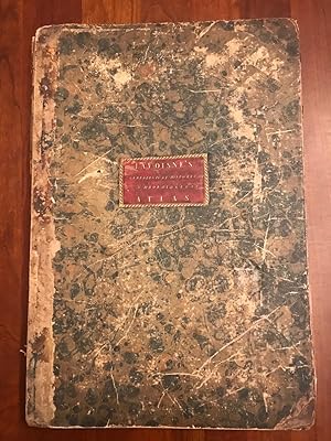
Lavoisne's Complete Genealogical Historical Chronological and Geographical Atlas, Upon the Plan of Le Sage; Exhibiting the Origin, Descent, and Marriages of All the Royal Families, from the Earliest Records, to The Year 1834.
Lingua: Inglese
Editore: J. Barfield, London, 1829
Da: Dublin Bookbrowsers, Dublin, NONE, Irlanda
Valutazione del venditore 2 su 5 stelle

EUR 235,59
Spedizione EUR 10,40
Spedito da Irlanda a U.S.A.Quantit�: 1 disponibili
Aggiungi al carrelloHardcover. Condizione: Good. Fourth Edition. Together with the Geographical Characteristics, foreign wars, Famous Battles, and remarkable events: to which is added, two new Historical Maps of the Church; and a new Map of the Archbishops, Bishops, Lord High Chancellors, Lord Chief Justices, Lord Mayors, &c. Being a General Guide to History, both Ancient and Modern. containing Forty-eight Genealogical, Historical and Chronological Maps, and Twenty-Six Geographical Maps. 4th ed.revised, and considerably enlarged, by John Satchell, Esq. Bound in calf overlapping spine & marbled boards with title gilt on black mo.label with decorative gilt margin at centre of front cover. Corners and spine ends bumped & rubbed. Front cover loose. Spine damaged with loss. Internally generally clean & bright with hand coloured maps & subscriber list. Externally about good and internally very good.
-
A complete genealogical, historical, chronological and geographical atlas: Lavoisne Atlas
Lingua: Inglese
Editore: M. Carey and Son, Philadelphia, 1820
Da: Rare & Antiquarian Book Finders, Dixon, IL, U.S.A.
Membro dell'associazione: MWABA
Valutazione del venditore 5 su 5 stelle
Hardcover. Condizione: Very Good. John Melish (illustratore). C V Lavoisne; C Gros; Jehoshaphat Aspin; E Paguenaud A complete genealogical, historical, chronological and geographical atlas; being a general guide to history, both ancient and modern: exhibiting an accurate account of the origin, descent, and marriages of all the royal families . the whole forming a complete system of history and geography Philadelphia, Published by M. Carey and Son; printed by T.H. Palmer, 1820-01-01. 2nd American ed., carefully rev. Hardcover. Good. Second American edition, published in the same year as the first American edition. Folio, 46 x 34 cm, (17 1/2 x 11 7/8 inches). Bound with contemporary gilt letter spine over boards. Beautiful marbled paper over boards both outside and inside covers. Original spine still holding except for a split at the bottom and a small chunk missing. See Pic. Original spine replaced paper. Sought after John Melish United States map in the back. Some paper loss on the title page with some small holes. Maps are in very good condition with a few small damp stains on the right corner.
-
A Complete Genealogical, Historical, Chronological, and Geographical Atlas
Editore: M. Carey and Sons, 1821
Hardcover. Condizione: Fair. No jacket. 3rd American edition, revised and corrected. From the library of 19th century American theologian John Williamson Nevin. ". Being a general guide to ancient and modern history: exhibiting an accurate account of the origin, descent, and marriages of the principal royal families from the earliest authentic records; together with the various possessions wars, celebrated Battles, and remarkable events, to the year 1821. "From the last London edition, Improved by C. Gros, of the University of Paris, and J. Aspin, professor of History, enlarged by the addition of several new maps of American History and Geography extended to the beginning of the year 1821." Detached covers. Ex-libris, with standard markings. Edgeworn.
-
Lavoisne's Complete Genealogical, Historical, Chronological and Geographical Atlas
Editore: J. Barfield, London, 1814
Da: Rooke Books PBFA, Bath, Regno Unito
Membro dell'associazione: PBFA
Valutazione del venditore 5 su 5 stelle
EUR 1.785,85
Spedizione EUR 23,11
Spedito da Regno Unito a U.S.A.Quantit�: 1 disponibili
Aggiungi al carrelloLeather. Condizione: Good Only. E. Paguenaud et al. (illustratore). A scarce new edition of this comprehensive Atlas, complete with sixty five colour atlas inspired maps. A new edition. First published in 1807.Folio.With sixty five double page leaves of colour plates, including the *48 plate entitled Genealogical, Historical and Chronological Map of the House of Nassau and Orange'. Dedication and list of subscriber's present. Collated complete.This 1814 edition is the first to contain the addition of eleven new historical maps. Drawing on the inspiration of an atlas, this fascinating work offers a new approach to learning history, and genealogy through a series of maps and diagrams. The atlas was created to provide a more interesting approach to the various and often confusing aspects of global history, and includes maps demonstrating notable battles and sieges during the Roman Empire, the discoveries of Columbus and a geographical map of the 'modern world'.Compiled by C. V. Lavoisne, who was a Professor at the University of Caen, and C. Gros, who was a Professor at the University of Paris. Lavoisne died before the completion of this work, and so it was continued by Gros.A scarce edition of this detailed and interesting approach to world history. In half calf. Externally worn with loss to the leather and rubbing to the boards and extremities. Joints weak. Internally strained in places. Ink stain and marks to the leaves. Preliminary leaves creased. Spotting and the occasional closed tear. Good Only. book.
-
A complete genealogical, historical, chronological and geographical ATLAS, 1820 hardcover
Editore: M. Carey and Son, 1820
Da: Larimar Animal Books, Morristown, NJ, U.S.A.
Valutazione del venditore 5 su 5 stelle
Hardcover. Condizione: Fair. No Jacket. A complete genealogical, historical, chronological, and geographical atlas being a general guide to history, both ancient and modern: An accurate account of the origin, descent and marriages of all the Royal Families, from the beginning of the world together with the various possessions, foreign wars, battles of renown and remarkable events, to the battle of Waterloo, and general peace of 1815; according to the plan of Le Sage, greatly improved the whole forming a complete system of History and Geography. 1820, M. Carey and Son. Maps and charts. Was a reference book in a library only markings are labels on inside of front and back covers and pencil number on a couple pages. Fair to Good hardcover. 12" x 18", unpaged 71 sections. Cover in rough condition, front cover was torn off, light age tone and light soil mostly on edges. Text with maps and charts and color coding as printed is in good condition. Oversize and heavy book - extra postage charges for priority mail in the U.S. and all mail out of the U.S. International mail is extremely expensive.
-
A New Genealogical, Historical, and Chronological Atlas; Being a Complete Guide to History, Both Ancient and Modern, Exhibiting an Accurate Account of the Origin, Descent, and Marriages of all the Royal Families, From the Beginning of the World to the Present Time
Editore: J. Barfield, London, 1807
Da: Jim Crotts Rare Books, LLC, Clemmons, NC, U.S.A.
Valutazione del venditore 2 su 5 stelle
Prima edizione
A collection of atlas inspired maps that show the genealogical and history of the world, organized in hand-coloured easy to read plates. The first edition of this work. SCARCE. With thirty-five hand-coloured double paged plates. With a key containing an explanation of the marks and abbreviations used in the maps. Collated, bound without plate twenty-two (which appears to binder error). This work is called an atlas, whereas it only drew inspiration from an atlas. It consists of genealogical and chronological tables that document important phases in history, rather than maps. The work is an interesting approach to learning history, laying out the chronology and genealogical of the world in a series of flow diagrams and easy to follow descriptive text. It was intended to provide a more entertaining resource from which children and adults could learn about various aspects of global history. The discussions of the maps include 'Sacred History, from the Creation to the Passover', 'A Map of the Roman Empire, from Julius Caesar to Aurelianus', and 'The History of France, from Pharamond to Pepin'. Compiled by C. V. Lavoisne, who was a Professor at the University of Caen, and C. Gros, who was a Professor at the University of Paris. Lavoisne died before the completion of this work, and so it was continued by Gros. Bound in the original marbled paper boards, both of which are detached. Many of the folio pages are oddly folded. Rather poor condition in its present state, but an excellent candidate for professional repair and rebinding.
-

A Complete Genealogical, Historical, Chronological, and Geographical Atlas; Being a General Guide to Ancient and Modern History: An Accurate Account of the Origin, Descent, and Marriages of the Principal Royal Families from the Earliest Authentic Records; Together with the Various Possessions, Wars, Celebrated Battles, and Remarkable Events, to the Year 1821. Enlarged by the Addition of Several New Maps of American History and Geography, Extended to the beginning of the Year 1821. Third American Edition, Carefully Revised and Corrected.
Editore: Philadelphia: Published by M. Carey and Sons, ., 1821
Da: Lighthouse Books, ABAA, Dade City, FL, U.S.A.
Membro dell'associazione: ABAA FABA ILAB
Valutazione del venditore 4 su 5 stelle

Folio, original half calf & boards, gilt-decorated spine. 28 double-page, handcolored copper-engraved maps and 40 double-page handcolored charts. Among the maps are four that relate particularly to AmericaL #1, "Geographical Map of the World;" #67, "North America - South American;" #68, "United States of America, compiled by John Melish; and #71, "Map of South America," by E. Paguenaud. The important Melish map of the United States is engraved on a full double-page sheet and is free os stains or repairs. Most other maps have surrounding text. Front cover and first two leaves hav ean old dampstain along fore-edge; the rear cover is nearly detached. Maps, American History, United States History, U.S. History, U.S.-iana, Americana, European History. JBS.
-
A New Genealogical, Historical, and Chronological Atlas; Being a Complete Guide to History, Both Ancient and Modern, Exhibiting an Accurate Account of the Origin, Descent, and Marriages of all the Royal Families, From the Beginning of the World to the Present Time
Editore: J. Barfield, London, 1807
Da: Rooke Books PBFA, Bath, Regno Unito
Membro dell'associazione: PBFA
Valutazione del venditore 5 su 5 stelle
Prima edizione
EUR 1.428,68
Spedizione EUR 23,11
Spedito da Regno Unito a U.S.A.Quantit�: 1 disponibili
Aggiungi al carrelloLeather. Condizione: Very Good. C. V. Lavoisne; C. Gros (illustratore). First edition. A collection of atlas inspired maps that show the genealogical and history of the world, organised in hand-coloured easy to read plates. The first edition of this work. A scarce work. With thirty-five hand-coloured double paged plates. With a key containing an explanation of the marks and abbreviations used in the maps. Collated, bound without plate twenty-two. This work is called an atlas, whereas it only drew inspiration from an atlas. It consists of genealogical and chronological tables that document important phases in history, rather than maps. The work is an interesting approach to learning history, laying out the chronology and genealogical of the world in a series of flow diagrams and easy to follow descriptive text. It was intended to provide a more entertaining resource from which children and adults could learn about various aspects of global history. The discussions of the maps include 'Sacred History, from the Creation to the Passover', 'A Map of the Roman Empire, from Julius Caesar to Aurelianus', and 'The History of France, from Pharamond to Pepin'. Compiled by C. V. Lavoisne, who was a Professor at the University of Caen, and C. Gros, who was a Professor at the University of Paris. Lavoisne died before the completion of this work, and so it was continued by Gros. In a quarter morocco binding with marbled paper to the boards. Externally, smart. Original label to the front board with some loss and rubbing. Internally, firmly bound. Pages are bright and generally clean with the odd mark and handling mark. Plate 25 with some loss to the bottom and fore edge, resulting in loss of some text. Very Good. book.
-
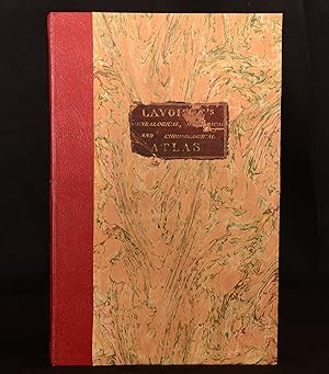
[TRAVEL] [MAPS] A COMPLETE GENEALOGICAL, HISTORICAL, CHRONOLOGICAL, AND GEOGRAPHICAL ATLAS; BEING A GENERAL GUIDE TO HISTORY, BOTH ANCIENT AND MODERN: EXHIBITING AN ACCURATE ACCOUNT OF THE ORIGIN, DESCENT, AND MARRIAGES OF ALL THE ROYAL FAMILIES FROM THE BEGINNING OF THE WORLD: TOGETHER WITH THE VARIOUS POSSESSIONS, FOREIGN WARS, BATTLES OF RENOWN AND REMARKABLE EVENTS, TO THE BATTLE OF WATERLOO . THE WHOLE FORMING A COMPLETE SYSTEM OF HISTORY AND GEOGRAPHY
Editore: M. Carey & Sons, Philadelphia, 1820
Da: BLACK SWAN BOOKS, INC., ABAA, ILAB, Richmond, VA, U.S.A.
Membro dell'associazione: ABAA ESA ILAB
Valutazione del venditore 5 su 5 stelle
Half Leather. Condizione: Very Good binding. First American Edition. The First American Edition of A Complete Genealogical, Historical, Chronological, and Geographical Atlas, executed by Matthew Carey in 1820. Complete with all maps and charts of 71 double-page plates -- including the important maps of the "United States of America" by John Melish, a 2-page maps showing Texas as a separate country and most of the Louisiana Purchase as Missouri Territory The copy with a hand made buckram cover, stitched to hold it in place, which has on it the signature of Thos. Picton, and the stamp of one Joseph Malcomsom Lurgan. Several of the maps have some dampstain, including the Melish map of the United States. The color throughout is strong and attractive. Very Good binding.
-
Lavoisne M., Atlas, anno 1820, with the Melish map A COMPLETE GENEALOGICAL, HISTORICAL, CHRONOLOGICAL, AND GEOGRAPHICAL ATLAS; BEING A GENERAL GUIDE TO HISTORY, BOTH ANCIENT AND MODERN: EXHIBITING AN ACCURATE ACCOUNT OF THE ORIGIN, DESCENT, AND MARRIAGES OF ALL THE ROYAL FAMILIES FROM THE BEGINNING OF THE WORLD: TOGETHER WITH THE VARIOUS POSSESSIONS, FOREIGN WARS, BATTLES OF RENOWN AND REMARKABLE EVENTS, TO THE BATTLE OF WATERLOO . THE WHOLE FORMING A COMPLETE SYSTEM OF HISTORY AND GEOGRAPHY M. Lavoisne Published by M. Carey & Sons, Philadelphia, 1820 The First American Edition of A Complete Genealogical, Historical, Chronological, and Geographical Atlas, executed by Matthew Carey in 1820. Complete with all maps and charts of 71 double-
Editore: Philadelphia, 1820
Da: Hammelburger Antiquariat, Hammelburg, Germania
Valutazione del venditore 5 su 5 stelle
EUR 1.400,00
Spedizione EUR 30,00
Spedito da Germania a U.S.A.Quantit�: 1 disponibili
Aggiungi al carrelloHardcover. Condizione: Ausreichend. Lavoisne M., Atlas, anno 1820, with the Melish map A COMPLETE GENEALOGICAL, HISTORICAL, CHRONOLOGICAL, AND GEOGRAPHICAL ATLAS; BEING A GENERAL GUIDE TO HISTORY, BOTH ANCIENT AND MODERN: EXHIBITING AN ACCURATE ACCOUNT OF THE ORIGIN, DESCENT, AND MARRIAGES OF ALL THE ROYAL FAMILIES FROM THE BEGINNING OF THE WORLD: TOGETHER WITH THE VARIOUS POSSESSIONS, FOREIGN WARS, BATTLES OF RENOWN AND REMARKABLE EVENTS, TO THE BATTLE OF WATERLOO . THE WHOLE FORMING A COMPLETE SYSTEM OF HISTORY AND GEOGRAPHY M. Lavoisne Published by M. Carey & Sons, Philadelphia, 1820 The First American Edition of A Complete Genealogical, Historical, Chronological, and Geographical Atlas, executed by Matthew Carey in 1820. Complete with all maps and charts of 71 double-page plates -- including the important maps of the "United States of America" by John Melish. Folio, some restorations. But the Melish map in good condition.
-
A complete genealogical, historical, chronological and geographical atlas; being a general guide to history, both ancient and modern: exhibiting an accurate account of the origin, descent, and marriages of all the royal families . the whole forming a complete system of history and geography
Editore: Philadelphia, Published by M. Carey and Son; printed by T.H. Palmer, 1820
Da: Sequitur Books, Boonsboro, MD, U.S.A.
Membro dell'associazione: IOBA
Valutazione del venditore 5 su 5 stelle
Hardcover. Condizione: Good. 2nd American ed., carefully rev. Second American edition, published in the same year as the first American edition. Folio, 46 x 34 cm, (17 1/2 x 11 7/8 inches). Bound with contemporary gilt letter spine over boards. Rebacked, with original leather spine retained. 5 preliminary leaves, 71 plates (part double; including maps, tables) of which 28 are double page maps. Maps nos. 38, 43, 46, 51 and 71 are by E. Paguenaud; no. 68 by John Melish. Nos. 17, 50, and 70 are single leaves with text on both sides. Maps and tables colored by hand. Occasional foxing. Four maps of America. The map of the United States by John Melish is particularly notable, because it includes detailed views of the Missouri and Columbia Rivers based on information from Lewis and Clark's expedition, and also includes the new state of Missouri. Rumsey 1642. Phillips 131. Wheat Transmississippi 338 (map of the United States). This is an oversized or heavy book, which requires additional postage for international delivery outside the US.
-
A new genealogical, historical, and chronological atlas ; being a complete guide to history . an accurate account of the origin, descent, and marriages of all the Royal families from the beginning of the world to the present time, complete in thirty-six maps
Editore: London: J. Barfield, 1807
Da: Sequitur Books, Boonsboro, MD, U.S.A.
Membro dell'associazione: IOBA
Valutazione del venditore 5 su 5 stelle
Prima edizione
Hardcover. Condizione: Good. First Edition. Folio; 44 cm. Bound in contemporary 1/2 calf. Red morocco cover label. Joints split, boards rubbed. 7 pages, 36 hand-colored genealogical charts. This is an oversized or heavy book, which requires additional postage for international delivery outside the US.
-
LAVOISNE'S COMPLETE GENEALOGICAL, HISTORICAL, CHRONOLOGICAL AND GEOGRAPHICAL ATLAS
Editore: Printed and Published By J. Barfield, London, 1840
Da: LOE BOOKS, Bathpool, CORNW, Regno Unito
Valutazione del venditore 4 su 5 stelle
EUR 1.428,68
Spedizione EUR 23,70
Spedito da Regno Unito a U.S.A.Quantit�: 1 disponibili
Aggiungi al carrelloHardcover. Condizione: Very Good. Condizione sovraccoperta: No Dust Jacket. Fourth Edition. "Revised, Collated and Considerably Enlarged by John Satchell Esq." Seventy-four double-page engraved genealogical tables and geographical maps all with original hand colouring, contemporary . half black morocco gilt, with green cloth boards. Binding good with some general wear and rubbing, leather chipped with loss to the base of the spine, joints rubbed but still strong, corners worn. All edges gilt./ Contents clean and tight, contemporary ink stain effecting the fore-edges of the first few pages, but not affecting text or maps, most noticeable to the front end papers with also have a pencil inscription dated 30 November 1935. All maps and charts in very good condition. Notwitstanding wear to the binding a very good copy. Size: Folio (30 x 46cm). Book.
-
A Complete Genealogical, Historical, Chronological, and Geographicl Atlas; being a general guide to Ancient and Modern History. enlarged by the addition of several new maps of American History and Geography
Editore: Philadelphia: M. Carey and Sons, May 22, 1821., 1821
Da: Arader Galleries - AraderNYC, New York, NY, U.S.A.
Valutazione del venditore 5 su 5 stelle
Hardcover. Folio (18 x 11 6/8 inches). Letterpress title-page (lower edges of preliminaries strengthened with archival tissue). 71 engraved maps and tables with original hand-colouring, and all but 3 double-page and mounted on guards (some occasional marginal spotting). Modern crimson morocco backed contemporary marbled paper boards (board edges worn with loss). Provenance: With the contemporary engraved bookplate of John Savage of Philadelphia on the front paste-down and his ownership inscription at the head of the title-page dated 1821. Third American edition "carefully revised and corrected" by C. Gros and J. Aspin, first published in America in 1820, and in London in 1807. Including the "Geographical, Historical, and Statistical Map of America", the celebrated map of the "United States of America" by John Melish, and "South America" and well as a chronological and historical table of America. Catalogued by Kate Hunter.
-

Map of South America Intended for the Elucidation of Lavoisne's Historical Atlas by E. Paguenaud
Editore: M Lavoisne, M. Carey & Son, Philadelphia, 1820
Da: mediumraremaps.com, Franklin, TN, U.S.A.
Valutazione del venditore 5 su 5 stelle
Mappa
20 3/4 x 16 1/2 inches. Very nice copy of this early American map of South America compiled for Lavoisne, atlas. The map was printed by copperplate with the text added at the time of publication using letterpress. The information in the text column bot left and right is focused on individual countries. This differs from Cary and Lea's later issue of a similar map where the physical geography is given primacy. Overall a very nice two century old map. Good condition with slight overall tanning. there is chipping to the upper left margin not affecting the printed surface. Upper area shows signs of heavy use.
-

Geogrpahical and Statistical Map of Spain and Portugal.
Editore: LondonJ. Barfield ., 1828
Da: Robert Frew Ltd. ABA ILAB, London, Regno Unito
Membro dell'associazione: ABA ILAB PBFA
Valutazione del venditore 5 su 5 stelle
Mappa
EUR 119,06
Spedizione EUR 11,56
Spedito da Regno Unito a U.S.A.Quantit�: 1 disponibili
Aggiungi al carrelloOriginal engraved map (27 x 33 cm, overall sheet 47 x 57 cm) of Spain and Portugal, with flags indicating 'Places Remarkable for Battles and Sieges'. With comprehensive information about both countries, including, rivers, mountains, universities, climate, government, religion, and merino sheep. Centrefold crease as issued. Some light foxing to margins, creases to upper corners and across lower half of sheet, affecting text only.
-

Genealogical, Historical and Chronological Map pf Portugal, from the founding of the Monarchy under Count Henry of Burgundy, 1092, to the year 1828 (cuadro genealogico reyes de Portugal)
Editore: c. 1830, Philadelphia, 1830
Arte / Stampa / Poster
EUR 355,00
Spedizione EUR 50,00
Spedito da Spagna a U.S.A.Quantit�: 1 disponibili
Aggiungi al carrelloCondizione: ACEPTABLE. A complete Genealogical, Historical, Chronological and Geographical Atlas, being a general guide to History. de M. Lavoisne. Editado en Philadelphia por Mathew Carey. - Printed by J. Barfield, Printer to His Majesty Formato (cm): 59x47.
-

Geographical and statistical map of Spain and Portugal. Map of Spain and Portugal
Editore: Londres, 1828
Arte / Stampa / Poster
EUR 355,00
Spedizione EUR 50,00
Spedito da Spagna a U.S.A.Quantit�: 1 disponibili
Aggiungi al carrelloCondizione: ACEPTABLE. . Including the places rendered celebrated by Battles & Sieges Intended for .of Lavoisnes Historical Atlas - By C. Gros, revised 1828 - London published by J. Barfield.printer to His Majesty Formato (cm): 56x45.
-
Lavoisne's Complete Genealogical, Historical, Chronological, and Geographical Atlas &c. &c.
Editore: London: Printed and Published by J. Barfield, Wardour Street, Soho, Printer to The Queen's Most Excellent Majesty, 1840
Da: Colin Page Books, Storrington, Regno Unito
Membro dell'associazione: ABA ILAB PBFA
Valutazione del venditore 5 su 5 stelle
EUR 476,23
Spedizione EUR 46,24
Spedito da Regno Unito a U.S.A.Quantit�: 1 disponibili
Aggiungi al carrelloLarge folio (48 x 33cm). The fourth edition, 'revised, collated and considerably enlarged, by John Satchell Esq.' pp. [2],4-8,[4],74ff. With 74 double page plates, of which 26 are hand coloured maps, the others coloured historical charts. The first map with some natural toning to the paper, otherwise clean & fresh. Bound in contemporary half morocco and marbled boards with label to front board, rebacked & re-cornered to style. Vg. [BMC 14, 999].
-
A COMPLETE GENEALOGICAL, HISTORICAL, CHRONOLOGICAL, AND GEOGRAPHICAL ATLAS
Da: John K King Used & Rare Books, Detroit, MI, U.S.A.
Valutazione del venditore 4 su 5 stelle
Copia autografata
M. Carey and Sons: Philadelphia 1821. 18 x 12", leather backed plain boards, ink inscription, very worn copy with numerous defects such as marginal staining, spotting, torn & wrinkled pp, and lacking map #70 but WITH 27 PAGES OF DOUBLE PAGE HAND COLORED MAPS PLUS NUMEROUS COLORED HISTORICAL CHARTS. (Has the wonderful Melish U.S. map).
-

Geographical and Statistical Map of France
Data di pubblicazione: 1820
Da: Art Source International Inc., Boulder, CO, U.S.A.
Valutazione del venditore 5 su 5 stelle
This beautiful map of France came from M. Lavoisnes Genealogical Historical Chronological and Geographical Atlas. Surrounding this colorful map is important textual information on geography, history, and major battles. ' This map measures 20.5 inches by 16.5 inches.
-

Chart of the World as Known to the Ancients and the Posterity of Noah
Data di pubblicazione: 1820
Da: Art Source International Inc., Boulder, CO, U.S.A.
Valutazione del venditore 5 su 5 stelle
This unique map of the world as known to the Ancients on Mercators projection and the Posterity of Noah came from M. Lavoisne's Genealogical Historical Chronological and Geographical Atlas. These maps show the outline of ancient empires and contains explanatory text with important historical information. This map measures 20.25 inches by 16.5 inches.
-
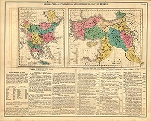
Geographical, Statistical and Historical Map of Turkey
Data di pubblicazione: 1820
Da: Art Source International Inc., Boulder, CO, U.S.A.
Valutazione del venditore 5 su 5 stelle
This beautiful and historical map of Turkey came from M. Lavoisnes Genealogical Historical Chronological and Geographical Atlas. The maps detail Turkey in Europe and in Asia (including Greece, Hungary and the Balkan region, the Black Sea region, and much of the Middle East). Below the maps is important textual information on the geography, culture, and history of the area. This map is accompanied by 4 hand-colored sheets of genealogical and historical tables on the Empires of the Turks, Parthians, Constantinople, and the Kingdom of Persia. This map measures 20.25 inches by 16.5 inches.
-
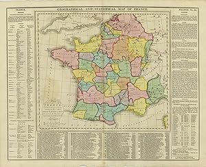
Geographical and Statistical Map of France
Data di pubblicazione: 1814
Da: Art Source International Inc., Boulder, CO, U.S.A.
Valutazione del venditore 5 su 5 stelle
Brightly-colored copper-plate map of France, surrounded by textual information regarding geography, history, political divisions, and battles. This is the oldest map by Lavoisne we have ever seen. This map measures 20 inches by 15.5 inches.
-
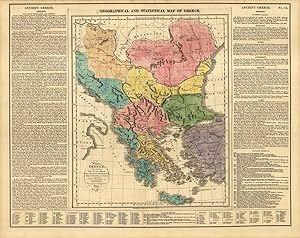
Geographical and Statistical Map of Greece
Data di pubblicazione: 1820
Da: Art Source International Inc., Boulder, CO, U.S.A.
Valutazione del venditore 5 su 5 stelle
This beautiful and historical map of Greece came from M. Lavoisnes Genealogical Historical Chronological and Geographical Atlas. Significant battle sites are marked with red flags on the map. Surrounding this brightly colored map is important textual information on the geography and history of Greece. This map is accompanied by two pages of hand colored genealogical and historical tables. This map measures 20.75 inches by 16.75 inches.
-
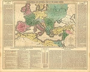
Geographical and Historical Map of the Roman Empire
Data di pubblicazione: 1820
Da: Art Source International Inc., Boulder, CO, U.S.A.
Valutazione del venditore 5 su 5 stelle
This beautiful map of the Roman Empire came from M. Lavoisnes Genealogical Historical Chronological and Geographical Atlas. Surrounding this brightly colored map is important textual information on the structure and history of the Empire, and the Campaign of Hannibal. This map is accompanied by 3 hand-colored sheets of genealogical and historical tables. This map measures 20.5 inches by 16.5 inches.
-

Map of South America
Data di pubblicazione: 1820
Da: Art Source International Inc., Boulder, CO, U.S.A.
Valutazione del venditore 5 su 5 stelle
This beautiful map of South America came from M. Lavoisnes Genealogical Historical Chronological and Geographical Atlas. Surrounding this brightly colored map is important textual information on geography and history. It is important to note that on this map, Chile is quite small, Patagonia is a separate country, and Argentina is La Plata or Buenos Ayres. This map measures 20.5 inches by 16.5 inches.
-
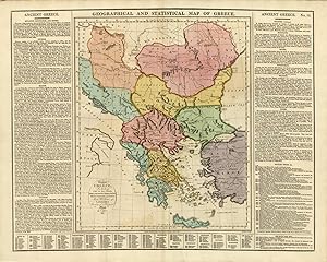
Geographical and Statistical Map of Greece
Data di pubblicazione: 1814
Da: Art Source International Inc., Boulder, CO, U.S.A.
Valutazione del venditore 5 su 5 stelle
Brightly-colored copper-plate map of Greece, surrounded by textual information regarding geography, history, and political divisions. This is the oldest map by Lavoisne we have ever seen. This map measures 20 inches by 15.5 inches.
-
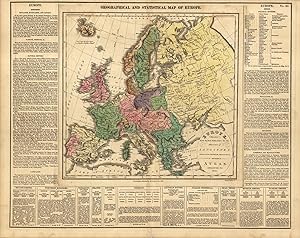
Geographical and Statistical Map of Europe
Data di pubblicazione: 1820
Da: Art Source International Inc., Boulder, CO, U.S.A.
Valutazione del venditore 5 su 5 stelle
This beautiful map of Europe came from M. Lavoisnes Genealogical Historical Chronological and Geographical Atlas. Surrounding this brightly colored map is textual information on geography, history, and political divisions. This map measures 20.5 inches by 16.5 inches.


![Immagine del venditore per [TRAVEL] [MAPS] A COMPLETE GENEALOGICAL, HISTORICAL, CHRONOLOGICAL, AND GEOGRAPHICAL ATLAS; BEING A GENERAL GUIDE TO HISTORY, BOTH ANCIENT AND MODERN: EXHIBITING AN ACCURATE ACCOUNT OF THE ORIGIN, DESCENT, AND MARRIAGES OF ALL THE ROYAL FAMILIES FROM THE BEGINNING OF THE WORLD: TOGETHER WITH THE VARIOUS POSSESSIONS, FOREIGN WARS, BATTLES OF RENOWN AND REMARKABLE EVENTS, TO THE BATTLE OF WATERLOO . THE WHOLE FORMING A COMPLETE SYSTEM OF HISTORY AND GEOGRAPHY venduto da BLACK SWAN BOOKS, INC., ABAA, ILAB](https://pictures.abebooks.com/inventory/md/md30781522792.jpg)


