
Importo totale (1 articolo articoli):
Destinazione ordine:

major radefeld (25 risultati)
Vai alla pagina principale dei risultati di ricerca
Filtri di ricerca
Tipo di articolo
- Tutti i tipi di prodotto
- Libri (1)
- Riviste e Giornali (Nessun altro risultato corrispondente a questo perfezionamento)
- Fumetti (Nessun altro risultato corrispondente a questo perfezionamento)
- Spartiti (Nessun altro risultato corrispondente a questo perfezionamento)
- Arte, Stampe e Poster (Nessun altro risultato corrispondente a questo perfezionamento)
- Fotografie (Nessun altro risultato corrispondente a questo perfezionamento)
- Mappe (24)
- Manoscritti e Collezionismo cartaceo (Nessun altro risultato corrispondente a questo perfezionamento)
Condizioni Maggiori informazioni
- Nuovo (Nessun altro risultato corrispondente a questo perfezionamento)
- Come nuovo, Ottimo o Quasi ottimo (1)
- Molto buono o Buono (3)
- Discreto o Mediocre (Nessun altro risultato corrispondente a questo perfezionamento)
- Come descritto (21)
Legatura
- Tutte
- Rilegato (1)
- Brossura (Nessun altro risultato corrispondente a questo perfezionamento)
Ulteriori caratteristiche
- Prima ed. (16)
- Copia autograf. (11)
- Sovracoperta (Nessun altro risultato corrispondente a questo perfezionamento)
- Con foto (25)
- Non Print on Demand (25)
Lingua (2)
Prezzo
- Qualsiasi prezzo
- Inferiore a EUR 20 (Nessun altro risultato corrispondente a questo perfezionamento)
- EUR 20 a EUR 45
- Superiore a EUR 45
Spedizione gratuita
- Spedizione gratuita in U.S.A. (Nessun altro risultato corrispondente a questo perfezionamento)
Paese del venditore
Valutazione venditore
-

Das K�nigreich Bayern. N�rdliche H�lfte Entw. u. gez. v. Major Radefeld
Editore: Bibliograph. Institut 1845-1855, Hildburghausen, 1845
Da: Antiquariat Reinhold Berg eK Inh. R.Berg, Regensburg, Germania
Membro dell'associazione: ILAB VDA
Valutazione del venditore 5 su 5 stelle

Mappa
EUR 35,00
Spedizione EUR 24,00
Spedito da Germania a U.S.A.Quantit�: 1 disponibili
Aggiungi al carrelloSteel engraving, hand colored in outline when published. Die Karte zeigt das Gebiet von Erfurt im Norden bis Regensburg im S�den. Frankfurt im Westen und Zwiesel im Osten. In excellent condition. 193 by 280mm (7� by 11 inches).
-

Die Gro�herzogth�mer Mecklenburg-Schwerin und Mecklenburg-Strelitz. Ma�stab 1:625 000. Aus Meyer's Handatlas.
Editore: Bibliographisches Institut, Hildburghausen, 1862
Da: Versandantiquariat H�sl, Neuried, Germania
Valutazione del venditore 5 su 5 stelle
Mappa
EUR 34,00
Spedizione EUR 28,00
Spedito da Germania a U.S.A.Quantit�: 1 disponibili
Aggiungi al carrelloCondizione: Befriedigend. Brief/Blatt/Landkarte Grenzkolorierte Stahlstichkarte der Gro�herzogt�mer Mecklenburg aus Meyer's Handatlas, entworfen von Major Radefeld in der Revision von L. Ravenstein. Mit einer Einschaltkarte Plan von Schwerin. Das Blatt ist teilw. etwas randrissig, an den R�ndern verschmutzt, am unteren Eck rechts stark fingerfleckig. Sprache / Language: de 1 Seiten. ca. 36,5 x 47 cm.
-

Die Südspitze von Süd America mit Patagonia
Editore: Hildburghausen, 1851
Da: Clive A. Burden Ltd., Chalfont St. Giles, BUCKS, Regno Unito
Membro dell'associazione: ABA ILAB
Valutazione del venditore 5 su 5 stelle
Mappa
EUR 44,88
Spedizione EUR 25,40
Spedito da Regno Unito a U.S.A.Quantit�: 1 disponibili
Aggiungi al carrelloNo binding. Condizione: Good. 260 x 195 mm., in early outline and recent wash colour, in good condition. An attractive map of Patagonia, a region which today is encompassed by Chile and Argentina. The name was first applied by Ferdinand Magellan in 1520. More recently the coastline reflects the voyages and surveys undertaken by Phillip Parker King (1826-30) and Robert FitzRoy (1832-36). Both included the HMS Beagle, the second included one Charles Darwin who spent some time exploring onshore. Argentina had gained independence in 1816, and Chile followed in 1818. In the ensuing decades both countries vied for control over the indigenous peoples of the region. In 1848 the Chilean government moved its main settlement to Punta Arenas enabling Chile to claim control of Tierra del Fuego and the Magellan Strait. The map is the work of Major Carl Christian Franz Radefeld (1788�1874) who became chief cartographer for Joseph Meyer, the publisher. It is engraved by Jean Adam. Provenance: Juan and Peggy Rada Collection. Tooley's Dictionary (1999-2004).
-

Südlichster Theil von America enthaltend Bolivia das südliche Brasilien, Paraguay, Chile, La Plata, Cisplatina und Patagonien
Editore: Hildburghausen, 1850
Da: Clive A. Burden Ltd., Chalfont St. Giles, BUCKS, Regno Unito
Membro dell'associazione: ABA ILAB
Valutazione del venditore 5 su 5 stelle
Mappa
EUR 44,88
Spedizione EUR 25,40
Spedito da Regno Unito a U.S.A.Quantit�: 1 disponibili
Aggiungi al carrelloNo binding. Condizione: Very Good. 220 x 265, early outline colour, in good condition. An attractive map of central South America around the troubled regions of Brazil, Paraguay, Argentina, Chile, and Bolivia. Cisplatina had been a Brazilian province from 1821 to 1828 at which point following the Preliminary Peace Convention in 1828 it became independent as Uruguay. Bolivia here still has access to the Pacific Ocean. This region would see the Paraguayan War (1864-70) which would decimate Paraguay and the War of the Pacific (1879-84). The map is the work of Major Carl Christian Franz Radefeld (1788�1874) who became chief cartographer for Joseph Meyer, the publisher. It is engraved by Jean Adam. Provenance: Juan and Peggy Rada Collection. Tooley's Dictionary (1999-2004).
-

K�nigreich Hannover. Herzogthum Braunschweig und Lippe'sche L�nder. Grenzkolorierte Orig.-Stahlstichkarte mit kleinen Pl�nen von Hannover und Umgebung + G�ttingen und Umgebung. Gez. v. Major Radefeld, rev. v. L. Ravenstein.
Editore: Hildburghausen, Bibliograph. Inst. 1861., 1861
Da: Antiquariat Heiner Henke, Passau, Germania
Membro dell'associazione: BOEV
Valutazione del venditore 5 su 5 stelle
EUR 40,00
Spedizione EUR 80,00
Spedito da Germania a U.S.A.Quantit�: 1 disponibili
Aggiungi al carrello37 x 33 cem. in 4 Segmenten auf Leinen aufgezogen. Gut erhalten.
-

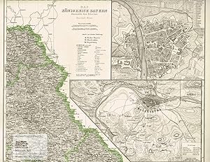
Das K�nigreich Bayern diesseite des Rheins, nach den Topographischen Karten des K�nigl. Bayr. Generalquartiermeisterstabes vom Jahr 1853, entw. u. gezeichnet in IV Bl�tter Major C. Radefeld 1858. II tes Blatt.
Editore: Bibliograph. Institut, Hildburghausen, 1858
Da: Antiquariat Reinhold Berg eK Inh. R.Berg, Regensburg, Germania
Membro dell'associazione: ILAB VDA
Valutazione del venditore 5 su 5 stelle
Mappa
EUR 60,00
Spedizione EUR 24,00
Spedito da Germania a U.S.A.Quantit�: 1 disponibili
Aggiungi al carrelloOriginal Stahlstich in zeitgen�ssischem Handkolorit. Die detaillierte Karte zeigt das K�nigreich Bayern diesseits des Rheins. In der oberen rechten Ecke ist eine Insetkarte der fr�nkischen Stadt W�rzburg. Darunter befindet sich eine Umgebungskarte von Regensburg. In ausgezeichnetem Zustand. 300 by 353mm (11� by 14 inches).
-

Provinz Ost-Preussen und West-Preussen. Stahlstich von Major Radefeld, revidiert von Ravenstein 1864
Lingua: Tedesco
Editore: Hildburghausen: Bibliographischen Instituts, 1864
Da: historicArt Antiquariat & Kunsthandlung, Wiesbaden-Breckenheim, Germania
Valutazione del venditore 5 su 5 stelle
Mappa Prima edizione Copia autografata
EUR 60,00
Spedizione EUR 12,00
Spedito da Germania a U.S.A.Quantit�: 1 disponibili
Aggiungi al carrello1. Original-Stahlstich von Major Radefeld (in der Platte signiert) auf r�ckseitig unbedrucktem B�ttenblatt, bildliche Darstellung ca. 30 x 36 cm, Blattgr��e ca. 37 x 47 cm, sehr detailierte Landkarte der Provinz Preu�en mit deutschem undpreu�ischem Meilenzeiger, von R�genwalde im Westen bis Tilsit im Osten, sauber und sehr gut erhalten 2100 gr.
-

K�nigreich Bayern. Nordwestliches Blatt. Landkarte von Bayern mit Franken von Aschaffenburg bis Baireuth mit kleinen Innenkarten von F�rth und N�rnberg sowie Bamberg. Stahlstich von Feuerstein nach Major Radefeld, revidiert von Ludwig Ravenstein 1860
Lingua: Tedesco
Editore: Hildburghausen: Bibliographischen Instituts, 1860
Da: historicArt Antiquariat & Kunsthandlung, Wiesbaden-Breckenheim, Germania
Valutazione del venditore 5 su 5 stelle
Mappa Prima edizione Copia autografata
EUR 60,00
Spedizione EUR 12,00
Spedito da Germania a U.S.A.Quantit�: 1 disponibili
Aggiungi al carrello1. Original-Stahlstich von Feuerstein (in der Platte signiert) auf r�ckseitig unbedrucktem Blatt, bildliche Darstellung ca. 29 x 36 cm, Blattgr��e ca. 37 x 48 cm, sehr detaillierte und pr�zise Karte von Unterfranken, Mitelfranken, Oberfranken sowie Oberpfalz und Regensburg mit Innenkarten von Bamberg, F�rth und N�rnberg, in der letzten Revision von Ludwig Ravenstein, einzelne Tafel aus "Meyer's Hand-Atlas", sauber und sehr gut erhalten 2100 gr.
-
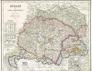
Ungarn und seine Nebenl�nder. Gro�e Landkarte von Ungarn und seinen Nachbarl�ndern mit kleiner Innenkarte von Buda und Pest. Grenzkolorierter Stahlstich nach Radefeld, revidiert von Ravenstein aus Meyer's Hand-Atlas 1867
Lingua: Tedesco
Editore: Hildburghausen: Bibliographischen Instituts, 1867
Da: historicArt Antiquariat & Kunsthandlung, Wiesbaden-Breckenheim, Germania
Valutazione del venditore 5 su 5 stelle
Mappa Prima edizione Copia autografata
EUR 60,00
Spedizione EUR 12,00
Spedito da Germania a U.S.A.Quantit�: 1 disponibili
Aggiungi al carrello1. gro�er Original-Stahlstich von Ravenstein (in der Platte signiert) auf r�ckseitig unbedrucktem B�ttenblatt aus Meyer's Hand-Atlas 1867, im Druck und von Hand grenz- und fl�chenkoloriert, extrem detailreiche und pr�zise Karte mit allen kleinen und gr��eren St�dten, Marktpl�tzen, Bergen, P�ssen, Fl�ssen und Seen, galt zum Zeitpunkt ihrer letzten Revision durch Ravenstein in der hier vorliegenden Fassung (1864) als pr�ziseste Landkarte der betreffenden Gebiete, bildliche Darstellung ca. 29 x 36 cm, Blattgr��e ca. 35 x 48 cm (jeweils H�he x Breite), sauber und sehr gut erhalten gro�er und/oder schwerer Artikel mit zus�tzlichen Kosten f�r Versand und Versicherung - heavy and/or oversized item with additional costs for shipping and insurance - will be dispatched enrolled in a solid mailing tube - please ask us before you order this article 2100 gr.
-

Provinz Brandenburg. Altkolorierte Landkarte von Brandenburg von der Uckermark im Norden bis zur Niederlausitz. Stahlstich von Radefeld revidiert von Ravenstein 1861
Lingua: Tedesco
Editore: Hildburghausen: Bibliographischen Instituts, 1861
Da: historicArt Antiquariat & Kunsthandlung, Wiesbaden-Breckenheim, Germania
Valutazione del venditore 5 su 5 stelle
Mappa Prima edizione Copia autografata
EUR 70,00
Spedizione EUR 12,00
Spedito da Germania a U.S.A.Quantit�: 1 disponibili
Aggiungi al carrello1. Original-Stahlstich von Radefeld (in der Platte signiert) auf r�ckseitig unbedrucktem Blatt, bildliche Darstellung ca. 29 x 36 cm, Blattgr��e ca. 37 x 48 cm, sehr detaillierte und pr�zise Karte, einzelne Tafel aus "Meyer's Hand-Atlas", von alter Hand sehr gewissenhaft grenzkoloriert, sauber und sehr gut erhalten 2100 gr.
-

Das K�nigreich der Niederlande mit den Grossherzothume Luxemburg, dem Herzogthume Limburg und K�nigreich Belgien. Gro�e Landkarte von Irland. Grenzkolorierter Stahlstich nach Radefeld, revidiert von Ravenstein aus Meyer's Hand-Atlas 1867
Lingua: Tedesco
Editore: Hildburghausen: Bibliographischen Instituts, 1867
Da: historicArt Antiquariat & Kunsthandlung, Wiesbaden-Breckenheim, Germania
Valutazione del venditore 5 su 5 stelle
Mappa Prima edizione
EUR 70,00
Spedizione EUR 12,00
Spedito da Germania a U.S.A.Quantit�: 1 disponibili
Aggiungi al carrello1. gro�er Original-Stahlstich auf r�ckseitig unbedrucktem B�ttenblatt aus Meyer's Hand-Atlas 1867, im Druck und von Hand sehr pr�zise grenzkoloriert, bildliche Darstellung ca. 37 x 29,5 cm, Blattgr��e ca. 48 x 37 cm (jeweils H�he x Breite), kleiner blasser Fleck neben dem Titel, im �u�ersten Blattrand leicht gegilbt, ansonsten sehr gut erhalten gro�er und/oder schwerer Artikel mit zus�tzlichen Kosten f�r Versand und Versicherung - heavy and/or oversized item with additional costs for shipping and insurance - will be dispatched enrolled in a solid mailing tube - please ask us before you order this article 2100 gr.
-

Ireland. Gro�e Landkarte von Irland. Grenzkolorierter Stahlstich nach Radefeld, revidiert von Ravenstein aus Meyer's Hand-Atlas 1867
Lingua: Tedesco
Editore: Hildburghausen: Bibliographischen Instituts, 1867
Da: historicArt Antiquariat & Kunsthandlung, Wiesbaden-Breckenheim, Germania
Valutazione del venditore 5 su 5 stelle
Mappa Prima edizione
EUR 70,00
Spedizione EUR 12,00
Spedito da Germania a U.S.A.Quantit�: 1 disponibili
Aggiungi al carrello1. gro�er Original-Stahlstich auf r�ckseitig unbedrucktem B�ttenblatt aus Meyer's Hand-Atlas 1867, im Druck und von Hand sehr pr�zise grenzkoloriert, bildliche Darstellung ca. 37 x 30 cm, Blattgr��e ca. 48 x 37 cm (jeweils H�he x Breite), sauber und sehr gut erhalten gro�er und/oder schwerer Artikel mit zus�tzlichen Kosten f�r Versand und Versicherung - heavy and/or oversized item with additional costs for shipping and insurance - will be dispatched enrolled in a solid mailing tube - please ask us before you order this article 2100 gr.
-
Das K�nigreich Bayern diesseits des Rheins. Nord�sl. Blatt. Gro�e Landkarte des K�nigreichs Bayern mit zwei Innenkarten mit Stadtgrundriss von W�rzburg am Main und Regensburg an der Donau mit Umgebung. Grenzkolorierter Stahlstich von Feuerstein nach Ravenstein aus Meyer's Hand-Atlas 1867
Lingua: Tedesco
Editore: Hildburghausen: Bibliographischen Instituts, 1867
Da: historicArt Antiquariat & Kunsthandlung, Wiesbaden-Breckenheim, Germania
Valutazione del venditore 5 su 5 stelle
Mappa Prima edizione Copia autografata
EUR 70,00
Spedizione EUR 12,00
Spedito da Germania a U.S.A.Quantit�: 1 disponibili
Aggiungi al carrello1. gro�er Original-Stahlstich von Feuerstein (in der Platte signiert) auf r�ckseitig unbedrucktem B�ttenblatt aus Meyer's Hand-Atlas 1867, im Druck und von Hand sehr pr�zise grenzkoloriert, bildliche Darstellung ca. 30 x 35,5 cm, Blattgr��e ca. 37 x 48 cm (jeweils H�he x Breite), sauber und sehr gut erhalten gro�er und/oder schwerer Artikel mit zus�tzlichen Kosten f�r Versand und Versicherung - heavy and/or oversized item with additional costs for shipping and insurance - will be dispatched enrolled in a solid mailing tube - please ask us before you order this article 2100 gr.
-
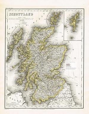
Schottland. Gro�e Landkarte von den Hebriden und den Orkney Islands im Norden bis Dumfries im S�den mit kleiner Innenkarte der Shetland Islands. Gro�er grenzkolorierter Stahlstich nach Radefeld, revidiert von Ravenstein aus Meyer's Hand-Atlas 1867
Lingua: Tedesco
Editore: Hildburghausen: Bibliographischen Instituts, 1867
Da: historicArt Antiquariat & Kunsthandlung, Wiesbaden-Breckenheim, Germania
Valutazione del venditore 5 su 5 stelle
Mappa Prima edizione
EUR 75,00
Spedizione EUR 12,00
Spedito da Germania a U.S.A.Quantit�: 1 disponibili
Aggiungi al carrello1. gro�er Original-Stahlstich auf r�ckseitig unbedrucktem B�ttenblatt aus Meyer's Hand-Atlas 1867, im Druck und von Hand sehr pr�zise grenzkoloriert, bildliche Darstellung ca. 37 x 29 cm, Blattgr��e ca. 48 x 37 cm (jeweils H�he x Breite), sauber und sehr gut erhalten gro�er und/oder schwerer Artikel mit zus�tzlichen Kosten f�r Versand und Versicherung - heavy and/or oversized item with additional costs for shipping and insurance - will be dispatched enrolled in a solid mailing tube - please ask us before you order this article 2100 gr.
-

Neueste Karte von Schweden und Norwegen 1850. Entworf. u. gezeichn. v. Major Radefeld.
Editore: Bibliograph. Institut, Hildburghausen, 1850
Da: Antiquariat Reinhold Berg eK Inh. R.Berg, Regensburg, Germania
Membro dell'associazione: ILAB VDA
Valutazione del venditore 5 su 5 stelle
Mappa
EUR 95,00
Spedizione EUR 24,00
Spedito da Germania a U.S.A.Quantit�: 1 disponibili
Aggiungi al carrelloOther. Original steel engraving engraved and drawn by Capt. Radefeld, published in Meyer's 'Handatlas', hand colored in outline when published. This antique map shows Norway, Denmark and Sweden. The map has three inset maps. One shows the Stockholm, the other the region about Christiania and G�teborg. Inside the map are many place names, rivers, mountains, etc. In excellent condition. 374 by 298mm (14� by 11� inches). 374 by 298mm (14� by 11� inches).
-
ALLEMAGNE DEUTSCHLAND RADEFELD CARTE COULEURS MAP MEYER Z22
Lingua: Tedesco
Editore: Allemagne, 1850
Da: Librairie RAIMOND, Dourges, Francia
Valutazione del venditore 5 su 5 stelle
Mappa
EUR 70,00
Spedizione EUR 20,00
Spedito da Francia a U.S.A.Quantit�: 1 disponibili
Aggiungi al carrelloPas de couverture. Condizione: Tr�s bon. Joseph MEYER CARTE GENERALE DE L'ALLEMAGNE - DEUTSCHLAND 1850 l�gendes en allemand, rehauts de couleurs � la main, dress� par le Major RADEFELD (Gravure authentique du XIXe si�cle-original engraving) Dimensions de la feuille : 27,2 x 27,2 cm environ Dimensions de la gravure au coup de planche : 22,5 x 18,5 cm environ Etat : tr�s beau document pr�cis, beaux coloris (ref-Z22).
-
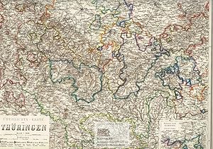
�bersichts-Karte von Th�ringen. Gro�e Landkarte von Th�ringen mit "politischem Colorit" mit kleiner Innenkarte der Meiningischen Parzelle Kamburg. Gro�er grenzkolorierter Stahlstich von Petters nach Radefeld, revidiert von Ravenstein aus Meyer's Hand-Atlas 1867
Lingua: Tedesco
Editore: Hildburghausen: Bibliographischen Instituts, 1867
Da: historicArt Antiquariat & Kunsthandlung, Wiesbaden-Breckenheim, Germania
Valutazione del venditore 5 su 5 stelle
Mappa Prima edizione Copia autografata
EUR 80,00
Spedizione EUR 12,00
Spedito da Germania a U.S.A.Quantit�: 1 disponibili
Aggiungi al carrello1. gro�er Original-Stahlstich von Petters (in der Platte signiert) auf r�ckseitig unbedrucktem B�ttenblatt aus Meyer's Hand-Atlas 1867, im Druck und von Hand sehr pr�zise grenzkoloriert, bildliche Darstellung ca. 34 x 43 cm, Blattgr��e ca. 37 x 48 cm (jeweils H�he x Breite), sauber und sehr gut erhalten gro�er und/oder schwerer Artikel mit zus�tzlichen Kosten f�r Versand und Versicherung - heavy and/or oversized item with additional costs for shipping and insurance - will be dispatched enrolled in a solid mailing tube - please ask us before you order this article 2100 gr.
-

Europa. Politische Uebersicht. Gro�e Landkarte der L�nder Europas mit Russland bis zum Ural. Pr�chtig grenzkolorierter Stahlstich von Major Radeveld, revidiert von Ravenstein aus Meyer's Hand-Atlas 1867
Lingua: Tedesco
Editore: Hildburghausen: Bibliographischen Instituts, 1867
Da: historicArt Antiquariat & Kunsthandlung, Wiesbaden-Breckenheim, Germania
Valutazione del venditore 5 su 5 stelle
Mappa Prima edizione
EUR 80,00
Spedizione EUR 12,00
Spedito da Germania a U.S.A.Quantit�: 1 disponibili
Aggiungi al carrello1. gro�er Original-Stahlstich nach Radeveld und Ravenstein auf r�ckseitig unbedrucktem B�ttenblatt aus Meyer's Hand-Atlas 1867, extrem detailreiche Darstellung, im Druck und von Hand sehr pr�zise grenzkoloriert, bildliche Darstellung ca. 30 x 37 cm, Blattgr��e ca. 37 x 47 cm (jeweils H�he x Breite), sauber und sehr gut erhalten gro�er und/oder schwerer Artikel mit zus�tzlichen Kosten f�r Versand und Versicherung - heavy and/or oversized item with additional costs for shipping and insurance - will be dispatched enrolled in a solid mailing tube - please ask us before you order this article 2100 gr.
-

Die Schweiz. Gro�e Landkarte der Schweiz von Schaffhausen im Norden bis Lugano im S�den. Grenzkolorierter Stahlstich nach Radefeld, revidiert von Ravenstein aus Meyer's Hand-Atlas 1867
Lingua: Tedesco
Editore: Hildburghausen: Bibliographischen Instituts, 1867
Da: historicArt Antiquariat & Kunsthandlung, Wiesbaden-Breckenheim, Germania
Valutazione del venditore 5 su 5 stelle
Mappa Prima edizione Copia autografata
EUR 80,00
Spedizione EUR 12,00
Spedito da Germania a U.S.A.Quantit�: 1 disponibili
Aggiungi al carrello1. gro�er Original-Stahlstich von Radefeld und Ravenstein (in der Platte signiert) auf r�ckseitig unbedrucktem B�ttenblatt aus Meyer's Hand-Atlas 1867, im Druck und von Hand grenzkoloriert, extrem detailreiche und pr�zise Karte mit allen kleinen und gr��eren St�dten, Marktpl�tzen, Bergen, P�ssen, Fl�ssen und Seen, galt zum Zeitpunkt ihrer letzten Revision durch Ravenstein in der hier vorliegenden Fassung (1863) als pr�ziseste Landkarte der Schweizerischen Eidgenossenschaft �berhaupt, bildliche Darstellung ca. 35 x 42 cm, Blattgr��e ca. 37 x 47 cm (jeweils H�he x Breite), sauber und sehr gut erhalten gro�er und/oder schwerer Artikel mit zus�tzlichen Kosten f�r Versand und Versicherung - heavy and/or oversized item with additional costs for shipping and insurance - will be dispatched enrolled in a solid mailing tube - please ask us before you order this article 2100 gr.
-
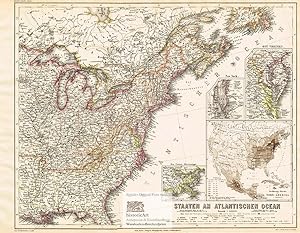
Staaten am Atlantischen Ozean. Large map of the Eastern States of the United States of America on the Atlantic Ocean with small inside maps of New York, Eastern Virginia and the Lower Mississippi. Colored steel engraving by Plath after Ravenstein from Meyer's Hand-Atlas 1867
Lingua: Tedesco
Editore: Hildburghausen: Bibliographischen Instituts, 1867
Da: historicArt Antiquariat & Kunsthandlung, Wiesbaden-Breckenheim, Germania
Valutazione del venditore 5 su 5 stelle
Mappa Prima edizione Copia autografata
EUR 80,00
Spedizione EUR 12,00
Spedito da Germania a U.S.A.Quantit�: 1 disponibili
Aggiungi al carrello1. gro�er Original-Stahlstich von Plath (in der Platte signiert) auf r�ckseitig unbedrucktem B�ttenblatt aus Meyer's Hand-Atlas 1867, im Druck und von Hand sehr pr�zise grenzkoloriert, bildliche Darstellung ca. 34 x 43 cm, Blattgr��e ca. 37 x 48 cm (jeweils H�he x Breite), sauber und sehr gut erhalten - gro�er und/oder schwerer Artikel mit zus�tzlichen Kosten f�r Versand und Versicherung - heavy and/or oversized item with additional costs for shipping and insurance - will be dispatched enrolled in a solid mailing tube - please ask us before you order this article 2100 gr.
-

Karte von Australien. Gro�e Landkarte von Australien mit Innenkarten von Port Philip und Melbourne, Port Jackson und Botany Bay und Neu Seeland (New Zealand). Grenzkolorierter Stahlstich von E.G. Ravenstein nach Major Radefeld aus Meyer's Hand-Atlas 1867
Lingua: Tedesco
Editore: Hildburghausen: Bibliographischen Instituts, 1867
Da: historicArt Antiquariat & Kunsthandlung, Wiesbaden-Breckenheim, Germania
Valutazione del venditore 5 su 5 stelle
Mappa Prima edizione Copia autografata
EUR 80,00
Spedizione EUR 12,00
Spedito da Germania a U.S.A.Quantit�: 1 disponibili
Aggiungi al carrello1. gro�er Original-Stahlstich von E.G. Ravenstein (in der Platte signiert) nach Radefeld auf r�ckseitig unbedrucktem B�ttenblatt aus Meyer's Hand-Atlas 1867, im Druck und von Hand sehr pr�zise grenzkoloriert, bildliche Darstellung ca. 33 x 44 cm, Blattgr��e ca. 36,5 x 47,5 cm (jeweils H�he x Breite), sauber und sehr gut erhalten gro�er und/oder schwerer Artikel mit zus�tzlichen Kosten f�r Versand und Versicherung - heavy and/or oversized item with additional costs for shipping and insurance - will be dispatched enrolled in a solid mailing tube - please ask us before you order this article 2100 gr.
-

Jran, Turan, Persien, Afghanistan, Beludschistan, Turkestan. Nach den besten Quellen entworfen und gezeichnet vom Major Radefeld. Gro�e Landkarte von Persien und Afghanistan vom Aral See im Norden bis zum Persischen Golf im S�den. Gro�er altkolorierter Stahlstich aus Meyer's Grossem Zeitungs-Atlas 1850
Editore: Hildburghausen: Bibliographischen Instituts, 1850
Da: historicArt Antiquariat & Kunsthandlung, Wiesbaden-Breckenheim, Germania
Valutazione del venditore 5 su 5 stelle
Mappa Prima edizione Copia autografata
EUR 120,00
Spedizione EUR 12,00
Spedito da Germania a U.S.A.Quantit�: 1 disponibili
Aggiungi al carrello1. gro�er Original-Stahlstich von Major Radefeld (in der Platte signiert) auf r�ckseitig unbedrucktem B�ttenblatt aus Meyer's Grossem Zeitungs-Atlas 1850, von alter Hand sehr pr�zise grenz- und fl�chenkoloriert, bildliche Darstellung ca. 30 x 36 cm, Blattgr��e ca. 36 x 44 cm (jeweils H�he x Breite), im rechten Blattrand au�erhalb der bildlichen Darstellung etwas Alterspatina, ansonsten sauber und sehr gut erhalten, sehr selten 2100 gr.
-

Karte von Polynesien. Gro�e Landkarte von Australien und Neu Seeland, Micronesien, den Salomonen, Neu Caledonien, den Carolinen, Sandwich Inseln, Fidschi Inseln, Tonga, Tahiti, Marshall Inseln und Galapagos Inseln im Pazifischen Ozean. Grenzkolorierter Stahlstich von E.G. Ravenstein nach Major Radefeld aus Meyer's Hand-Atlas 1867
Lingua: Tedesco
Editore: Hildburghausen: Bibliographischen Instituts, 1867
Da: historicArt Antiquariat & Kunsthandlung, Wiesbaden-Breckenheim, Germania
Valutazione del venditore 5 su 5 stelle
Mappa Prima edizione Copia autografata
EUR 90,00
Spedizione EUR 12,00
Spedito da Germania a U.S.A.Quantit�: 1 disponibili
Aggiungi al carrello1. gro�er Original-Stahlstich von E.G. Ravenstein (in der Platte signiert) nach Radefeld auf r�ckseitig unbedrucktem B�ttenblatt aus Meyer's Hand-Atlas 1867, im Druck und von Hand sehr pr�zise grenzkoloriert, bildliche Darstellung ca. 34 x 44 cm, Blattgr��e ca. 37 x 47 cm (jeweils H�he x Breite), sauber und sehr gut erhalten gro�er und/oder schwerer Artikel mit zus�tzlichen Kosten f�r Versand und Versicherung - heavy and/or oversized item with additional costs for shipping and insurance - will be dispatched enrolled in a solid mailing tube - please ask us before you order this article 2100 gr.
-

Das Koenigreich D�nemark und die Herzogth�mer Schleswig-Holstein u. Lauenburg. Gro�e Landkarte von D�nemark, Schleswig-Holstein und Lauenburg mit sch�ner Innenkarte von Island und Stadtgrundriss von Kopenhagen. Grenzkolorierter Stahlstich nach Radefeld, revidiert von Ravenstein aus Meyer's Hand-Atlas 1867
Lingua: Tedesco
Editore: Hildburghausen: Bibliographischen Instituts, 1867
Da: historicArt Antiquariat & Kunsthandlung, Wiesbaden-Breckenheim, Germania
Valutazione del venditore 5 su 5 stelle
Mappa Prima edizione
EUR 90,00
Spedizione EUR 12,00
Spedito da Germania a U.S.A.Quantit�: 1 disponibili
Aggiungi al carrello1. gro�er Original-Stahlstich auf r�ckseitig unbedrucktem B�ttenblatt aus Meyer's Hand-Atlas 1867, im Druck und von Hand sehr pr�zise grenzkoloriert, bildliche Darstellung ca. 37 x 30 cm, Blattgr��e ca. 48 x 37 cm (jeweils H�he x Breite), sauber und sehr gut erhalten gro�er und/oder schwerer Artikel mit zus�tzlichen Kosten f�r Versand und Versicherung - heavy and/or oversized item with additional costs for shipping and insurance - will be dispatched enrolled in a solid mailing tube - please ask us before you order this article 2100 gr.
-

Neueste Karte von Australien. Nach den bessten Quellen entworfen und gezeichnet vom Major Radefeld.
Editore: Bibliograph. Institut, Hildburghausen, 1850
Da: Antiquariat Reinhold Berg eK Inh. R.Berg, Regensburg, Germania
Membro dell'associazione: ILAB VDA
Valutazione del venditore 5 su 5 stelle
Mappa
EUR 175,00
Spedizione EUR 24,00
Spedito da Germania a U.S.A.Quantit�: 1 disponibili
Aggiungi al carrelloOther. Steel engraving, hand colored in outline when published. A decorative map of Australia and the Pacific Ocean published in Meyer's famous 'Grossen Zeitungsatlas'. In excellent condition. 211 by 264mm (8� by 10� inches). 211 by 264mm (8� by 10� inches).
