
Importo totale (1 articolo articoli):
Destinazione ordine:

radefeld (135 risultati)
Vai alla pagina principale dei risultati di ricerca
Filtri di ricerca
Tipo di articolo
- Tutti i tipi di prodotto
- Libri (41)
- Riviste e Giornali (Nessun altro risultato corrispondente a questo perfezionamento)
- Fumetti (Nessun altro risultato corrispondente a questo perfezionamento)
- Spartiti (Nessun altro risultato corrispondente a questo perfezionamento)
- Arte, Stampe e Poster (4)
- Fotografie (Nessun altro risultato corrispondente a questo perfezionamento)
- Mappe (89)
- Manoscritti e Collezionismo cartaceo (1)
Condizioni Maggiori informazioni
- Nuovo (15)
- Come nuovo, Ottimo o Quasi ottimo (18)
- Molto buono o Buono (18)
- Discreto o Mediocre (Nessun altro risultato corrispondente a questo perfezionamento)
- Come descritto (84)
Legatura
Ulteriori caratteristiche
- Prima ed. (16)
- Copia autograf. (11)
- Sovracoperta (Nessun altro risultato corrispondente a questo perfezionamento)
- Con foto (120)
- Non Print on Demand (122)
Lingua (3)
Spedizione gratuita
Paese del venditore
Valutazione venditore
-

4 Ansichten (Gastwirtschaft M.Dietrich, Dorfstrasse, Schule, Kirche). Ansichtskarte in Photodruck. Ungelaufen.
Lingua: Tedesco
Editore: Leipzig, Wernicke, um 1930., 1930
Da: Antiquariat Heinz Tessin, Quickborn, Germania
Valutazione del venditore 5 su 5 stelle

Manoscritto / Collezionismo cartaceo
EUR 8,00
Spedizione EUR 4,00
Spedito da Germania a U.S.A.Quantit�: 1 disponibili
Aggiungi al carrello9,0 x 14,0 cm. Die Portokosten betragen im Inland 1,00 Euro. [SW - Postkarte, Postkarten, Ansichtskarte].
-

Marocco, Algier und Tunis 1846. Stahlstichkarte mit Grenzkolorit. Gez. von Radefeld 1846.
Editore: Hildburghausen: Bibliographisches Institut ff, 1857
Da: Antiquariat Ralf Einhorn, Niesky, Germania
Valutazione del venditore 4 su 5 stelle

EUR 9,00
Spedizione EUR 7,60
Spedito da Germania a U.S.A.Quantit�: 1 disponibili
Aggiungi al carrelloBlattgr��e: 29,5:23,5 cm. Bildgr��e: 25,4:20 cm. Unter Passepartout. Mit 3 Nebenk�rtchen: Marocco (Stadt). Algier und Umgebung. Plan von Constantine.- In der Mitte gefaltet. Aus: Meyers Zeitungs-Atlas.
-

th�ringen
Editore: bibl. inst. 1896, 1896
Da: Antiquariat Walter Nowak, G�ttingen, Germania
Valutazione del venditore 4 su 5 stelle
EUR 7,00
Spedizione EUR 9,90
Spedito da Germania a U.S.A.Quantit�: 1 disponibili
Aggiungi al carrellomeyers reiseb�cher - 13. auflage Gewicht in Gramm: 550 r�cken etwas geklebt,einband berieben,innen sauber.
-

Frankreich. 1855. Stahlstichkarte mit Grenzkolorit. Entworfen u. gez. v. Radefeld. Revidirt 1856.
Editore: Hildburghausen: Bibliographisches Institut ff, 1857
Da: Antiquariat Ralf Einhorn, Niesky, Germania
Valutazione del venditore 4 su 5 stelle
EUR 11,00
Spedizione EUR 7,60
Spedito da Germania a U.S.A.Quantit�: 1 disponibili
Aggiungi al carrelloBlattgr��e: 29,5:23,5 cm. Bildgr��e: 25,2:18,8 cm. Unter Passepartout. - Mit einem Nebenk�rtchen: Gegend von Paris. In der Mitte gefaltet, Aus: Meyers Zeitungs-Atlas.
-

Das Adriameer mit seinen Uferstaaten. Gezeichnet von Major Radefeld 1858. Stahlstichkarte mit Grenzkolorit.
Editore: Hildburghausen: Bibliographisches Institut ff, 1857
Da: Antiquariat Ralf Einhorn, Niesky, Germania
Valutazione del venditore 4 su 5 stelle
EUR 11,00
Spedizione EUR 7,60
Spedito da Germania a U.S.A.Quantit�: 1 disponibili
Aggiungi al carrelloBlattgr��e: 29,5:23,5 cm. Bildgr��e: 23,5:17,4 cm. Unter Passepartout. - Italien mit Gegenk�ste im S�den bis Otranto. In der Mitte gefaltet, an den R�ndern gebr�unt. Aus: Meyers Zeitungs-Atlas.
-

Ireland. Stahlstichkarte mit Grenzkolorit. Bergzeichnung von Radefeld.
Editore: Hildburghausen: Bibliographisches Institut ff, 1857
Da: Antiquariat Ralf Einhorn, Niesky, Germania
Valutazione del venditore 4 su 5 stelle
EUR 11,00
Spedizione EUR 7,60
Spedito da Germania a U.S.A.Quantit�: 1 disponibili
Aggiungi al carrelloBlattgr��e: 29,5:23,5 cm. Bildgr��e: 17,4:23,3 cm. Unter Passepartout. - Mit einer Nebenkarte: Dublin und Umgebung. In der Mitte gefaltet. Aus: Meyers Zeitungs-Atlas.
-

Grossherzogthum Baden. S�dliche H�lfte. Stahlstichkarte mit Grenzkolorit. Entw. u. gez. v. C. Radefeld 1856.
Editore: Hildburghausen: Bibliographisches Institut ff, 1857
Da: Antiquariat Ralf Einhorn, Niesky, Germania
Valutazione del venditore 4 su 5 stelle
EUR 15,00
Spedizione EUR 7,60
Spedito da Germania a U.S.A.Quantit�: 1 disponibili
Aggiungi al carrelloBlattgr��e: 29,5:23,5 cm. Bildgr��e: 24,2:18,4 cm. Unter Passepartout. - Im Norden bis Achern. In der Mitte gefaltet. Aus: Meyers Zeitungs-Atlas.
-

�ber den spezifischen Unterschied des Christianismus vom Naturalismus,: zur Beurteilung einer Neuerung, welche mit dem Christennamen im Werke ist (German Edition)
Da: Ria Christie Collections, Uxbridge, Regno Unito
Valutazione del venditore 5 su 5 stelle
EUR 19,52
Spedizione EUR 13,74
Spedito da Regno Unito a U.S.A.Quantit�: Pi� di 20 disponibili
Aggiungi al carrelloCondizione: New. In.
-

Grenzkolorierte Karte aus Meyer s Groschen-Atlas.
Editore: Hildburghausen. Bibliographisches Institut 1852., 1852
Da: Antiquariat Bernd Pre�ler, Ahnatal Weimar, Germania
Valutazione del venditore 4 su 5 stelle
EUR 7,20
Spedizione EUR 29,00
Spedito da Germania a U.S.A.Quantit�: 1 disponibili
Aggiungi al carrelloAltersgem�� tadelloses Blatt. (27 x 31, 5 cm au�en). Kein Versand aufgrund von EPR Regelungen in EU-L�nder au�erhalb Deutschlands. No shipping to EU countries outside of Germany due to EPR regulations.
-
Meyers Reiseb�cher Th�ringen
Editore: Bibliographisches Institut Leipzig und Wien,, 1894
Da: Bernhard Kiewel Rare Books, Gr�nberg, Germania
Valutazione del venditore 5 su 5 stelle
EUR 6,00
Spedizione EUR 41,95
Spedito da Germania a U.S.A.Quantit�: 1 disponibili
Aggiungi al carrelloZw�lfte Auflage. 276 Seiten. Mit 14 Karten, 4 Pl�nen und 1 Panorama. OKart. Ordnungsgem�� aus einer Universit�ts-Bibliothek ausgesondert (Stempel, Signatur). Sauberes, gut erhaltenes Exemplar. Sprache: Deutsch Gewicht in Gramm: 202.
-

Neueste Karte von Nubien, Habesch, Kordofan und Darfur. No. 48.
Editore: Bibliographisches Institut, Hildburghausen Amsterdam Paris Philadelphia, 1844
Da: Versandantiquariat H�sl, Neuried, Germania
Valutazione del venditore 5 su 5 stelle
Mappa
EUR 34,00
Spedizione EUR 9,50
Spedito da Germania a U.S.A.Quantit�: 1 disponibili
Aggiungi al carrelloCondizione: Befriedigend. Stahlstichkarte mit Grenzkolorit von Hauptmann Radefeld aus J. Meyer's Hand-Atlas. Das Blatt hat am oberen Rand deutliche Randl�suren und tr�gt einen handschriftl. Zahlenvermerk rechts oben. Sprache / Language: de 1 Seiten. ca. 36,7 x 45,8 cm.
-
Grossherzogthum Oldenburg - F�rstenthum L�beck - F�rstenthum Birkenfeld
Editore: Biographischen Institut Hildburghausen, 1862
Da: Antiquariat Luna, L�neburg, Germania
Valutazione del venditore 5 su 5 stelle
Mappa
EUR 25,00
Spedizione EUR 20,00
Spedito da Germania a U.S.A.Quantit�: 1 disponibili
Aggiungi al carrelloKein Einband. Condizione: Befriedigend. Ma�stab 1:650000, Gebrauchs- und Alterspuren, gefaltet, an der Falz kleine Einrisse, altersgebr�unt Size: 24x30 cm. Karte.
-

"Der Grosse Ocean und Australien" - Australien Australia Pacific Ocean America Russia map carte Karte
Lingua: Tedesco
Editore: Hildburghausen, 1849
Da: Antiquariat Steffen V�lkel GmbH, Seubersdorf, Germania
Membro dell'associazione: ILAB VDA
Valutazione del venditore 5 su 5 stelle
Mappa
EUR 9,99
Spedizione EUR 30,00
Spedito da Germania a U.S.A.Quantit�: 1 disponibili
Aggiungi al carrelloOriginal altkolorierte Stahlstich-Karte von 1849. -- Blattmasse ca.25,5 x31,5cm. -- gut erhalten.|| Original old colored engraved map from 1849. -- in good condition. || Dies ist ein Original! - Kein Nachdruck! - Keine Kopie! -- This is an original! - No copy! - No reprint! // Wir, das Antiquariat Steffen V�lkel, kaufen und verkaufen alte B�cher, Handschriften, Zeichnungen, Autographen, Grafiken und Fotografien. Wir sind stets am Ankauf von kompletten Bibliotheken, Sammlungen und Nachl�ssen interessiert. Sprache: Deutsch Gewicht in Gramm: 1550.
-
Meyers Reiseb�cher. TH�RINGEN.
Lingua: Tedesco
Editore: Leipzig und Wien, Bibliographisches Institut,, 1898
Da: Antiquariat am Ungererbad-Wilfrid Robin, M�nchen, Germania
Valutazione del venditore 5 su 5 stelle
EUR 18,00
Spedizione EUR 22,50
Spedito da Germania a U.S.A.Quantit�: 1 disponibili
Aggiungi al carrelloCondizione: Gut. Bll. + 272 S., inkl. Register + 21 S. Anzeiger zum Th�ringer Wegweiser (14. Jahrg. 1899/1900) u. mit 14 Karten, 7 Pl�nen und 1 Panorama. Papier minimal nach- oder randgebr�unt. Sprache: Deutsch Gewicht in Gramm: 220 Kl.-8�, Or.-HalbLnw. (Bordeaux-Rot), mit Titelung. Kl. Alters- u. Gebrauchsspuren. Gutes Exemplar. Vierzehnte Auflage, bearbeitet unter mitwirkung des Th�ringerwald-Vereins.
-

Australia: Neueste Karte Von Australien, 1846
Lingua: Inglese
Data di pubblicazione: 1846
Da: Hornseys, Ripon, Regno Unito
Membro dell'associazione: PBFA
Valutazione del venditore 5 su 5 stelle
EUR 41,34
Spedizione EUR 28,67
Spedito da Regno Unito a U.S.A.Quantit�: 1 disponibili
Aggiungi al carrelloNo Binding. Condizione: Very Good. Date: 1846. Original steel engraving. Sheet size: 43.2cm x 36.2cm. A detailed map of the South Pacific with inset maps of New South Wales, Van Diemen's Land and Western Australia. Blank to the reverse. Contemporary outline hand-colouring. Minor age toning which is mainly confined to the margins. A very good indeed, bright, clean copy. SR: Sleeve: 1111 Map Drawer D.
-

Das K�nigreich Bayern. N�rdliche H�lfte Entw. u. gez. v. Major Radefeld
Editore: Bibliograph. Institut 1845-1855, Hildburghausen, 1845
Da: Antiquariat Reinhold Berg eK Inh. R.Berg, Regensburg, Germania
Membro dell'associazione: ILAB VDA
Valutazione del venditore 5 su 5 stelle
Mappa
EUR 35,00
Spedizione EUR 24,00
Spedito da Germania a U.S.A.Quantit�: 1 disponibili
Aggiungi al carrelloSteel engraving, hand colored in outline when published. Die Karte zeigt das Gebiet von Erfurt im Norden bis Regensburg im S�den. Frankfurt im Westen und Zwiesel im Osten. In excellent condition. 193 by 280mm (7� by 11 inches).
-
MAP: GROSSBRITANNIEN UND IRELAND (GREAT BRITAIN AND IRELAND)
Editore: Bibliographischen Instituts Hildburghausen, Germany, 1844
Da: Luis Porretta Fine Arts, Nanaimo RPO Country Club, BC, Canada
Valutazione del venditore 4 su 5 stelle
EUR 38,52
Spedizione EUR 24,09
Spedito da Canada a U.S.A.Quantit�: 1 disponibili
Aggiungi al carrelloNon-Book. Condizione: Very Good. Condizione sovraccoperta: No Dust Jacket. This engraved map is a little foxed, edges chipped, later hand coloring, fine detail. An interesting and seldom seen map. Country boundaries hand col. Relief shown by hachures. Shows ship and railroad routes, etc. ; 14" x 17".
-

Die Gro�herzogth�mer Mecklenburg-Schwerin und Mecklenburg-Strelitz. Ma�stab 1:625 000. Aus Meyer's Handatlas.
Editore: Bibliographisches Institut, Hildburghausen, 1862
Da: Versandantiquariat H�sl, Neuried, Germania
Valutazione del venditore 5 su 5 stelle
Mappa
EUR 34,00
Spedizione EUR 28,00
Spedito da Germania a U.S.A.Quantit�: 1 disponibili
Aggiungi al carrelloCondizione: Befriedigend. Brief/Blatt/Landkarte Grenzkolorierte Stahlstichkarte der Gro�herzogt�mer Mecklenburg aus Meyer's Handatlas, entworfen von Major Radefeld in der Revision von L. Ravenstein. Mit einer Einschaltkarte Plan von Schwerin. Das Blatt ist teilw. etwas randrissig, an den R�ndern verschmutzt, am unteren Eck rechts stark fingerfleckig. Sprache / Language: de 1 Seiten. ca. 36,5 x 47 cm.
-

England Bergzeichnung v. Hauptm Radefeld. 1852.
Editore: Bibliograph. Institut, Hildburghausen, 1852
Da: Antiquariat Reinhold Berg eK Inh. R.Berg, Regensburg, Germania
Membro dell'associazione: ILAB VDA
Valutazione del venditore 5 su 5 stelle
Mappa
EUR 40,00
Spedizione EUR 24,00
Spedito da Germania a U.S.A.Quantit�: 1 disponibili
Aggiungi al carrelloOther. Steel engraving, handcolored in outline, when published. Small and decorative map of England, showing many place names, rivers, mountains, streets and railroads. In excellent condition. 265 by 215mm (10� by 8� inches). 265 by 215mm (10� by 8� inches).
-

Frankreich 1845 - Entw. u. gez. v. Hauptmann Radefeld.
Editore: Bibliograph. Institut, Hildburghausen, 1845
Da: Antiquariat Reinhold Berg eK Inh. R.Berg, Regensburg, Germania
Membro dell'associazione: ILAB VDA
Valutazione del venditore 5 su 5 stelle
Mappa
EUR 40,00
Spedizione EUR 24,00
Spedito da Germania a U.S.A.Quantit�: 1 disponibili
Aggiungi al carrelloOther. Steel engraving, hand colored in outline. Still in good condition. 293 by 359mm (11� by 14� inches). 293 by 359mm (11� by 14� inches).
-

Th�ringen. Bearbeitet unter Mitwirkung des Th�ringerwald-Vereins.
Lingua: Tedesco
Editore: Leipzig, Bibliographisches Institut,, 1890
Da: Antiquariat Matthias Drummer, Berlin, Germania
Valutazione del venditore 5 su 5 stelle
EUR 18,00
Spedizione EUR 37,00
Spedito da Germania a U.S.A.Quantit�: 1 disponibili
Aggiungi al carrello10. Auflage. X, 1 Blatt, 271 Seiten, 16 Seiten Anzeigen, Mit 16 Karten und Pl�nen und einem Panorama. Neben-Untertitel: "Wegweiser Th�ringen". Der R�cken mit Abklatsch der rostigen Klammern, beide Einbanddeckel mit Knickspuren l�ngs und mit schwachen Schabstellen, wenige Eselsohren. Insgesamt aber durchaus ordentliches und sauberes, vor allem aber vollst�ndiges Exemplar Sprache: Deutsch Gewicht in Gramm: 258 Original-Halbleinen, 10x15cm, Zustand: 3.
-
"Neuste Karte von Salzburg. Entw. u. gez. v. Hauptm. Radefeld". Aus: Meyer's Hand-Atlas.
Editore: Hildburghausen, Bibliographisches Institut. 1843., 1843
Da: Antiquariat MEINDL & SULZMANN OG, Wien - Vienna, Austria
Valutazione del venditore 5 su 5 stelle
EUR 30,00
Spedizione EUR 35,00
Spedito da Austria a U.S.A.Quantit�: 1 disponibili
Aggiungi al carrelloBlattgr��e ca. 34 x 42 cm. Bildausschnitt ca. 29 x 35,5 cm.
-
Th�ringen.
Editore: Leipzig und Wien: Bibliographisches Institut, 1896
Da: ANTIQUARIAT B�CHERBERG Martin Walkner, Salzburg, Austria
Valutazione del venditore 5 su 5 stelle
EUR 82,00
Spedizione EUR 24,00
Spedito da Austria a U.S.A.Quantit�: 1 disponibili
Aggiungi al carrello13. Auflage. XI+300+24 S. mit 15 Karten, 6 Pl�nen (teils gefaltet) und 1 Falt-Panorama (Inselsberg). Rotes Halbleinen, Klammerheftung, 16 cm. Sch�nes Exemplar fast ohne Gebrauchsspuren, Einband kaum besto�en und fleckig, Papier kaum gebr�unt. - Meyers Reiseb�cher. - Bearb. unter Mitwirkung d. Th�ringerwald-Vereins 1898. Anzeiger zum Th�ringer Wegweiser, 11. Jg. 1896/1897. - Index (Register) u. Anhang (Anzeigen). tk [Von Schweizer Bankkonten keine Bank�berweisung, nur Kreditkartenzahlung �ber Abebooks/ZVAB] Sprache: Deutsch. - Gewicht in Gramm: 300. - Reisef�hrer. - Stichworte: Reise, Reisef�hrer, Tourismus, Europa, Deutsches Reich, Ostdeutschland. -.
-

Schottland Bergzeichnung v. Hauptm Radefeld. 1848.
Editore: Bibliograph. Institut, Hildburghausen, 1848
Da: Antiquariat Reinhold Berg eK Inh. R.Berg, Regensburg, Germania
Membro dell'associazione: ILAB VDA
Valutazione del venditore 5 su 5 stelle
Mappa
EUR 45,00
Spedizione EUR 24,00
Spedito da Germania a U.S.A.Quantit�: 1 disponibili
Aggiungi al carrelloOther. Steel engraving, hand colored in outline, when published. Small and decorative map of Scotland, showing many place names, rivers, mountains, streets and railroads. Ornated with two inset maps: Orkney islands - Shetland islands. In excellent condition. 240 by 202mm (9� by 8 inches).
-

EUR 12,90
Spedizione EUR 70,00
Spedito da Germania a U.S.A.Quantit�: 5 disponibili
Aggiungi al carrelloTaschenbuch. Condizione: Neu. �ber den spezifischen Unterschied des Christianismus vom Naturalismus, | zur Beurteilung einer Neuerung, welche mit dem Christennamen im Werke ist | Johann Radefeld | Taschenbuch | 60 S. | Deutsch | 2017 | hansebooks | EAN 9783743437654 | Verantwortliche Person f�r die EU: Hansebooks GmbH, Trakehner Weg 52, 22844 Norderstedt, gb[at]hansebooks[dot]com | Anbieter: preigu.
-
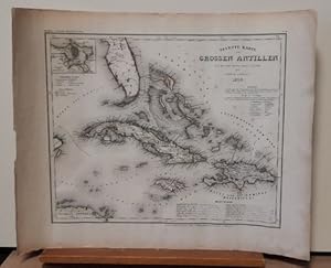
Neueste Karte der Grossen Antillen (Teilkolorierte Stahlstichkarte aus Meyers Grosser Stahlstich-Atlas)
Editore: Hildburghausen, Amsterdam, Paris und Philadelphia, Verlag des Bibliographischen Instituts, 1850
Da: ANTIQUARIAT H. EPPLER, Karlsruhe, Germania
Valutazione del venditore 5 su 5 stelle
Mappa
EUR 50,00
Spedizione EUR 19,95
Spedito da Germania a U.S.A.Quantit�: 1 disponibili
Aggiungi al carrelloCondizione: Gut. 46x36,5cm Gerollt, etwas anger�ndert, insges. gut. Sprache: Englisch, -------- Ansicht von Kuba, Jamaika und Haiti sowie einem Teil von Florida.
-

Schottland Bergzeichnung v. Hauptm Radefeld. 1849.
Editore: Bibliograph. Institut, Hildburghausen, 1849
Da: Antiquariat Reinhold Berg eK Inh. R.Berg, Regensburg, Germania
Membro dell'associazione: ILAB VDA
Valutazione del venditore 5 su 5 stelle
Mappa
EUR 45,00
Spedizione EUR 24,00
Spedito da Germania a U.S.A.Quantit�: 1 disponibili
Aggiungi al carrelloOther. Steel engraving, hand colored in outline, when published. Small and decorative map of Scotland, showing many place names, rivers, mountains, streets and railroads. Ornated with two inset maps: Orkney islands - Shetland islands. In excellent condition. 240 by 202mm (9� by 8 inches). 240 by 202mm (9� by 8 inches).
-

Die Südspitze von Süd America mit Patagonia
Editore: Hildburghausen, 1851
Da: Clive A. Burden Ltd., Chalfont St. Giles, BUCKS, Regno Unito
Membro dell'associazione: ABA ILAB
Valutazione del venditore 5 su 5 stelle
Mappa
EUR 44,88
Spedizione EUR 25,40
Spedito da Regno Unito a U.S.A.Quantit�: 1 disponibili
Aggiungi al carrelloNo binding. Condizione: Good. 260 x 195 mm., in early outline and recent wash colour, in good condition. An attractive map of Patagonia, a region which today is encompassed by Chile and Argentina. The name was first applied by Ferdinand Magellan in 1520. More recently the coastline reflects the voyages and surveys undertaken by Phillip Parker King (1826-30) and Robert FitzRoy (1832-36). Both included the HMS Beagle, the second included one Charles Darwin who spent some time exploring onshore. Argentina had gained independence in 1816, and Chile followed in 1818. In the ensuing decades both countries vied for control over the indigenous peoples of the region. In 1848 the Chilean government moved its main settlement to Punta Arenas enabling Chile to claim control of Tierra del Fuego and the Magellan Strait. The map is the work of Major Carl Christian Franz Radefeld (1788�1874) who became chief cartographer for Joseph Meyer, the publisher. It is engraved by Jean Adam. Provenance: Juan and Peggy Rada Collection. Tooley's Dictionary (1999-2004).
-

Südlichster Theil von America enthaltend Bolivia das südliche Brasilien, Paraguay, Chile, La Plata, Cisplatina und Patagonien
Editore: Hildburghausen, 1850
Da: Clive A. Burden Ltd., Chalfont St. Giles, BUCKS, Regno Unito
Membro dell'associazione: ABA ILAB
Valutazione del venditore 5 su 5 stelle
Mappa
EUR 44,88
Spedizione EUR 25,40
Spedito da Regno Unito a U.S.A.Quantit�: 1 disponibili
Aggiungi al carrelloNo binding. Condizione: Very Good. 220 x 265, early outline colour, in good condition. An attractive map of central South America around the troubled regions of Brazil, Paraguay, Argentina, Chile, and Bolivia. Cisplatina had been a Brazilian province from 1821 to 1828 at which point following the Preliminary Peace Convention in 1828 it became independent as Uruguay. Bolivia here still has access to the Pacific Ocean. This region would see the Paraguayan War (1864-70) which would decimate Paraguay and the War of the Pacific (1879-84). The map is the work of Major Carl Christian Franz Radefeld (1788�1874) who became chief cartographer for Joseph Meyer, the publisher. It is engraved by Jean Adam. Provenance: Juan and Peggy Rada Collection. Tooley's Dictionary (1999-2004).
-

K�nigreich Hannover. Herzogthum Braunschweig und Lippe'sche L�nder. Grenzkolorierte Orig.-Stahlstichkarte mit kleinen Pl�nen von Hannover und Umgebung + G�ttingen und Umgebung. Gez. v. Major Radefeld, rev. v. L. Ravenstein.
Editore: Hildburghausen, Bibliograph. Inst. 1861., 1861
Da: Antiquariat Heiner Henke, Passau, Germania
Membro dell'associazione: BOEV
Valutazione del venditore 5 su 5 stelle
EUR 40,00
Spedizione EUR 80,00
Spedito da Germania a U.S.A.Quantit�: 1 disponibili
Aggiungi al carrello37 x 33 cem. in 4 Segmenten auf Leinen aufgezogen. Gut erhalten.
